Baudh State

Last updated

Baudh State
Princely State of British India
14th century–1948
Drapeau Baudh.png
Flag
SonpurKart.jpg
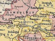
Baudh State in the Imperial Gazetteer of India
Area 
 1921
3,274 km2 (1,264 sq mi)
Population 
 1921
130,103
History
History 
 Established
14th century
1948
Succeeded by
India Flag of India.svg
Baudh Princely State

Baudh State, also known as Boudh State, was one of the princely states of India during the period of the British Raj. It was recognized as a state in 1874 and had its capital in Boudh town. Its last ruler signed the accession to the Indian Union on 1 January 1948.

Contents

History

According to traditions, after the fall of the Somavamshi dynasty to Eastern Gangas, local chieftains were installed in the region as feudatories. Upon time, a childless Brahmin chieftain adopted the nephew of the neighbouring Raja of Keonjhar who belonged to the Bhanj dynasty. This prince styled himself Ananga Deva and founded the state in the 14th century. [1]

See also

Related Research Articles

<span class="mw-page-title-main">Gajapati district</span> District of Odisha in India

Gajapati district is a district of Odisha State in India. It was created from Ganjam District on 2 October, 1992. Gajapati district was named after Krushna Chandra Gajapati Narayan Deb, the King of the Paralakhemundi estate and the first Prime Minister of Orissa, who is remembered for his contribution in the formation of a separate state, and inclusion of his estate in Odisha. The district headquarters at Paralakhemundi, formerly a Zamindari, has been clustered within a radius of approximately 5 kilometers around the geometric centre of Paralakhemundi. The District is a part of the Red Corridor. As of 2011 it is the third least populous district of Odisha, after Debagarh and Boudh.

<span class="mw-page-title-main">Bamra State</span>

Bamra State or Bamanda State, covering an area of 5149 km2, was one of the princely states of India during the period of the British Raj, its capital was in Debagarh (Deogarh). Bamra State acceded to India in 1948.

<span class="mw-page-title-main">Boudh district</span> District of Odisha in India

Boudh District is an administrative and a municipal district, one of the thirty in the Odisha, India. The district headquarters of the Boudh District is the city of Boudh.

Boudh is a town and a Notified Area Council in Boudh district in the state of Odisha, India. It is the district headquarters of Boudh district. It is located on the bank of Mahanadi, the largest river of the state of Odisha.

<span class="mw-page-title-main">Belaguntha</span> Town in Odisha, India

Bellaguntha is a town and a Notified Area Council (N.A.C.) in Odisha, India which was the main market of South Odisha in the time of British India. Bellaguntha is also known as Brass Fish Town.

<span class="mw-page-title-main">Phulbani</span> Town in Odisha, India

Phulbani is a municipality and administrative headquarters of Kandhamal district in the state of Odisha in India.

Western Odisha or the western part of Odisha, India, extending from the Kalahandi district in the south to the Sundargarh district in the north.

<span class="mw-page-title-main">Dashapalla</span> Town in Odisha, India

Dashapalla, also known as Daspalla, is an archaeologically important site situated in Nayagarh district, Odisha, India.

Kandhamal Lok Sabha constituency is one of the 21 Lok Sabha constituencies in Odisha state in eastern India. This constituency came into existence in 2008, following the implementation of delimitation of parliamentary constituencies based on the recommendations of the Delimitation Commission of India constituted in 2002.

Birmaharajpur is a subdivision town of Subarnapur district in the state of Odisha, India. Birmaharajpur Subdivisional Headquarter is the Birmaharajpur town. It is located 22 km towards east from district headquarter Sonepur. It is a dispersed town and located on the left bank of the river Mahanadi. It is located about 229 km from state capital Bhubaneswar.

The Harihara Deula or Twin Temples are dedicated to Lord Shiva and Lord Vishnu. They are situated near the bank of Mahanadi river, at Gandharadi village in Boudh district of Odisha, India.

Bhuvaneshwar Temple is located in Malipara in the Boudh township of Odisha, India. On the left side of road leading from Boudh to Sonepur, it is situated on the right bank of Mahanadi. It can be assigned to 10th Century, during Somavamsi rule. Decorated with architectural motifs like – khakharamundis, divine figures like Ganesha and Jaina Tirthankaras, semi-divine figures, nayikas, image of Linga puja, human figures both male and female, bharabahaka, decorative motifs like scroll work, beaded border, lattice pattern, padmaprosta motifs, mohanty design, vajramundi, animals, mithuna and maithuna. Nataraja and Brahma idols are also found. It can be categorized as Rekha deula of South Kosalan style. Shivaratri, Shitalasasthi and all Purnimas are important days here.

<span class="mw-page-title-main">Chari Sambhu Temple</span>

Chari Sambhu Temple or Gandharadi Temple is located at the bank of river Mahanadi at Gandharadi village of Boudh district of Odisha, India. It is famous for twin temples of Nilamadhava and Sidheswar. These temples display high quality architectural work. These temples were developed under the support of the Bhanja leaders of Khinjali mandala in ninth century AD. These temple attracts visitor throughout the year. The temple has been considered a religious site during the Baudh State.

Boudh is a Vidhan Sabha constituency of Boudh district, Odisha.

<span class="mw-page-title-main">Bonai State</span>

Bonai State, was a princely state during the British Raj in what is today India. It was one of the Chota Nagpur States and had its capital at Bonaigarh, located in the present-day Sundergarh district of Odisha. It had an area of 8,907 square kilometres (3,439 sq mi) and a population of 24,026 in 1892 with an average revenue of Rs.60,000 in 1901.

<span class="mw-page-title-main">Sonepur State</span> Former princely state of British India

Sonepur also known as Sonpur State, was one of the princely states of India during the period of the British Raj. Its ruler was entitled to a nine gun salute. Formerly it was placed under the Central India Agency, but in 1905 it was transferred to the Eastern States Agency. Its capital was Sonepur, the only significant town in the area. The former state's territory is in the present-day Subarnapur district, Odisha.

<span class="mw-page-title-main">Daspalla State</span>

Daspalla State (Odia: ଦଶପଲ୍ଲା was one of the princely states of India during the period of the British Raj. Its capital was Kunjabangarh, located in present-day Nayagarh district, Odisha.

The Bhanja dynasty is a dynasty that originated in the northern and central regions of modern Odisha before the Gupta Empire became an imperial power. The dynasty, of ancient local Kshatriya lineage as documented by Hermann Kulke, succeeded the Vindhyatabi branch of the Nagas of Padmavati, who ruled from the Keonjhar district of Odisha and included Satrubhanja of the Asanpat inscription. The Bhanj later became feudatories of the Bhauma-Kara dynasty.

<span class="mw-page-title-main">Nayagarh State</span>

Nayagarh State was one of the princely states of India from the period of the British Raj. It was located in present-day Nayagarh district, Odisha.

<span class="mw-page-title-main">Keonjhar State</span>

Keonjhar State, also known as Keunjhar, was one of the princely states of India during the period of the British Raj. The second largest of the states of the Orissa States Agency, it was located in present-day Kendujhar district, Odisha.

References

  1. ODISHA DISTRICT GAZETTEERS BOUDH (PDF), GAD, Govt of Odisha, 1991, p. 23

Coordinates: 20°50′N84°19′E / 20.84°N 84.32°E / 20.84; 84.32