The Central Provinces and Berar was a province of British India and later the Dominion of India which existed from 1903 to 1950. It was formed by the merger of the Central Provinces with the province of Berar, which was territory leased by the British from the Hyderabad State. Through an agreement signed on 5 November 1902, 6th Nizam Mahbub Ali Khan, Asaf Jah VI leased Berar permanently to the British for an annual payment of 25 lakhs rupees. Lord Curzon decided to merge Berar with the Central Provinces, and this was proclaimed on 17 September 1903.

Sakti is a city and a district in the state of Chhattisgarh. The assembly constituency number of District Sakti is 33, Earlier it was the only Education District of Chhattisgarh. There are 245 panchayats and 458 villages under Sakti district. Sakti district was formed on 15 August 2021 And came into complete district existence on 9 September 2022 by then Chief Minister Bhupesh Baghel.
Rajnandgaon is a city in Rajnandgaon District, in the state of Chhattisgarh, India. As of the 2011 census the population of the city was 163,122. Rajnandgaon district came into existence on 26 January 1973, as a result of the division of Durg district.

Korea State, currently spelt as Koriya, was a small princely state in the British Empire of India. After Indian independence in 1947, the ruler of Korea acceded to the Union of India on 1 January 1948, and Koriya was made part of Surguja District of Central Provinces and Berar province. In January 1950, "Central Provinces and Berar" province was renamed Madhya Pradesh state. After November 2000, Korea and the former princely state of Changbhakar became Koriya district of Chhattisgarh state.
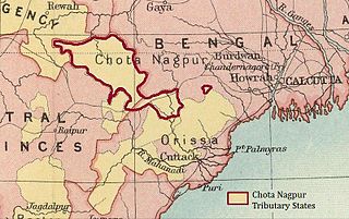
The Chota Nagpur Tributary States or Chota Nagpur States were a group of small, non-salute states during the British Raj in India, located on the Chota Nagpur Plateau. British suzerainty over the states was exercised through the government of the Bengal Presidency.
Chhuikhadan is a city municipality and district in Khairagarh-Chhuikhadan-Gandai district in the Indian state of Chhattisgarh, India. Chhuikhadan is also known as "City of Martyrs".
Chhattisgarh Division was an administrative division of the Central Provinces of British India. It was located in the east of the Central Provinces and encompassed the upper Mahanadi River basin, in the central part of present-day Chhattisgarh state of India.
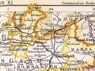
Sakti State was one of the princely states of India during the British Raj. It belonged to the Chhattisgarh States Agency, which later became the Eastern States Agency.

Khairagarh State was one of the princely states of India during the period of the British Raj. Khairagarh town in Khairagarh-Chhuikhadan-Gandai district of Chhattisgarh was the capital of the state and the seat of the Raja's residence.

Jashpur State was one of the princely states of India during the British Raj. The town of Jashpur was the former state's capital. The rulers were Rajputs of the Chauhan clan.

Nandgaon State, also known as Raj Nandgaon, was one of the princely states of India during the period of the British Raj. Nandgaon State, in present-day Rajnandgaon District of Chhattisgarh, was the only town of the state and the seat of the ruler's residence. The state was founded by Mahant Prahlad Das Bairagi in 1765 A.D. Nanadgaon State was ruled by Vaishnav Brahmins.

Jhabua State was one of the princely states of India during the period of the British Raj. It had its capital in Jhabua town. Most of the territory of the princely state was inhabited by the Bhil people, who constituted a majority of the population. The revenue of the state in 1901 was Rs.1,10,000.

The Eastern States Union was a short-lived (1947–48) union of princely states in newly independent India that gathered most of the princely states of the former Orissa Tributary States and Chhattisgarh States Agency in order to fill the vacuum of power created after the departure of the British and the wrapping up of the British Raj.
Khanda is a big and historical village in Kharkhoda tehsil of Sonipat district in Haryana, India. It is located 2 miles (3.2 km) from Kharkhoda and 7 miles (11 km) from Sonipat. It is a part of the Delhi NCR. Khanda has two Gram Panchayats Khanda Khas and Khanda Alman. Two Sarpanchs elects from the village in every five years. Khanda is the head of 12 villages of Dahiya Khap mainly known as.

Raja Mahant Digvijay Das was the last ruler of the princely state of Nandgaon in the present-day Rajnandgaon district of Chhattisgarh, India.
Mahant Raja Ghasi Das was the ruler of the princely state of Nandgaon in the present-day Rajnandgaon District of Chhattisgarh, India.
Sakti district is one of the four new district in the state of Chhattisgarh, India announced by Bhupesh Baghel on 15 August 2021. It is carved out from Janjgir-Champa district. The district was formerly the princely state of Sakti, which joined Bilaspur district after Independence.

Khairagarh-Chhuikhadan-GandaiKCG is a district in the central Indian state of Chhattisgarh which consists of three cities, Khairagarh, Chhuikhadan and Gandai. It was carved out of Rajnandgaon in 2022. It is the 31st district of the state inaugurated by chief minister Bhupesh Baghel.