Sundargarh is a town in Sundergarh district of the Indian state of Odisha. As of 2011 census, the municipality had a population of 45,036. Sundargarh is recognized as an industrial district in Odisha. Steel, fertilizer, cement, ferrovanadium, machine-building, glass, china-clay plants and factories, and spinning mills are some of the major industries of this district. Sundargarh occupies a prominent position in the mineral map of Odisha and is rich in iron ore, limestone, and manganese.
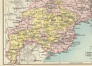
The Orissa Tributary States, also known as the Garhjats and as the Orissa Feudatory States, were a group of princely states of British India now part of the present-day Indian state of Odisha.

Dhenkanal State was one of the princely states of India during the period of the British Raj. The area of the former state is now referred to as Dhenkanal district, Odisha, with Dhenkanal town as its district headquarters.

Athmallik is one of the sub-divisional headquarters in the district of Angul in Odisha, India and it is a Notified Area Council in Angul. Earlier it cames under the Dhenkanal District but now it is a part of Angul District. The Athmallik sub-division of Angul includes Athmallik and Kishorenagar blocks.

Patna State was a princely state in the Eastern States Agency of India during the British Raj. It had its capital at Balangir. Its area was 6,503 km2 (2,511 sq mi).

Saraikela State also spelt Seraikela, Saraikella or Seraikella, was a small princely state in India during the British Raj, in the region that is now the Jharkhand state. Its capital was at Saraikela.

Kalahandi State, also known as Karond State, was one of the princely states of India during the British Raj. It was recognized as a state in 1874 and had its capital in Bhawanipatna. Its last ruler signed the accession to the Indian Union on 1 January 1948. The present titular head of the former state is Anant Pratap Deo who resides in the Kalahandi Palace in Bhawanipatna

Bonai State was a minor princely state during the British Raj in what is today India. It was one of the Chota Nagpur States and had its capital at Bonaigarh, located in the present-day Sundergarh district of Odisha. It had an area of 8,907 square kilometres (3,439 sq mi) and a population of 24,026 in 1892 with an average annual revenue of Rs.60,000 in 1901.

Udaipur State was one of the princely states of India during the period of the British Raj. The town of Dharamjaigarh was the former state's capital.

Sonepur, also known as Sonpur State, was one of the princely states of India during the period of the British Raj. Its ruler was entitled to a nine-gun salute. Formerly it was placed under the Central India Agency, but in 1905 it was transferred to the Eastern States Agency. Its capital was Sonepur, the only significant town in the area. The former state's territory is in the present-day Subarnapur district, Odisha.
Sambalpur State, also known as Hirakhand Kingdom, was a kingdom founded in 1570. It ruled over Western Odisha and Eastern Chhattisgarh in central-eastern India prior to the Maratha occupation in 1800 AD. From 1849 AD, it was integrated with British Raj as a British District. Its capital was present-day Sambalpur city in Western Odisha.

The Bhanja dynasty is a dynasty that originated in the northern and central regions of modern Odisha before the Gupta Empire became an imperial power. The dynasty, of ancient local Kshatriya lineage as documented by Hermann Kulke, succeeded the Vindhyatabi branch of the Nagas of Padmavati, who ruled from the Keonjhar district of Odisha and included Satrubhanja of the Asanpat inscription. The Bhanj later became feudatories of the Bhauma-Kara dynasty.

Mayurbhanj State was one of the princely states of India during the British Raj. It was one of the largest states of the Eastern States Agency and one of the three states of the Bengal States Agency. The emblem of the state was two peacocks, for according to legend the ancestors of the rulers had originated from a peafowl's eyes.
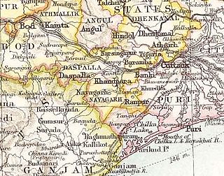
Nayagarh State was one of the princely states of India during the British Raj. It was located in present-day Nayagarh district, Odisha.
Ranpur State was one of many princely non-salute states of India during the period of the British Raj. It was one of the four native states located in present-day Nayagarh district, Odisha.

Kanker State was one of the princely states of India during the period of the British Raj. Its last ruler, Maharajadhiraj Bhanu Pratap Deo, signed the accession to the Indian Union in 1947.
Narsinghpur State was one of the princely states of India during the period of the British Raj. The state was founded in the 17th century and had its capital in Narasinghpur town. The last ruler of Narsinghpur joined the state to the Indian Union in 1948 and Narsinghpur state was made part of the Cuttack district of Odisha.

Tigiria State was one of the princely states of India during the period of the British Raj. It was located in present-day Tigiria block of Cuttack district, Odisha. Although it was the smallest of the states of the Orissa States Agency it was the most densely populated. The last ruler of Tigiria joined the state to the Indian Union in 1948.
Rairakhol State was a princely state during the British Raj in what is today India. It was one of the Chota Nagpur States and had its capital at Rairakhol (Redhakhol), located in the present-day Sambalpur district of Odisha. It had an area of 2,157 square kilometres (833 sq mi) and a population of 26,888 in 1901, the average revenue was Rs.55,000 in 1904.
