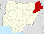
Abadam is a remote Local Government Area of Borno State, Nigeria, on the western coast of Lake Chad. It borders Chad and Niger, and it's very close to Cameroon, in 2016 its population is projected to be 140,000 inhabitants, It has its headquarters in the town of Malumfatori. Security, Healthcare, infrastructure, and climate change are some of the major challenges in Abadam Local government.
Marte is a Local Government Area of Borno State, Nigeria, on the western coast of Lake Chad. Its headquarters are in the town of Marte
Askira/Uba is a Local Government Area of Borno State, Nigeria. Its headquarters are in the town of Askira.
Gubio, also Gobiyo, is a Local Government Area of Borno State, in northeastern Nigeria. Its headquarters are in the town of Gubio.
Guzamala is a Local Government Area of Borno State, Nigeria. Its headquarters are in the town of Gudumbali. It's located approximately 125 kilometres north of the state capital, Maiduguri. It has an area of 2,517 km2 and a population of 95,648 at the 2006 census.

Gwoza is a local government area of Borno State, Nigeria. Its headquarters are in the town of Gwoza, a border town "about 135 kilometres South-East of Maiduguri." The postal code of the area is 610.

Hawul is a Local Government Area of Borno State, Nigeria. It's located in the southern part of the state.
Jere is a local government area of Borno State, Nigeria. It has its headquarters in the town of Khaddamari. London ciki is a community in Jere under maimusari ward.
Kaga is a Local Government Area of Borno State, Nigeria. Its headquarters are in the town of Benisheikh.
Kala/Balge is a Local Government Area of Borno State, Nigeria. It is the easternmost LGA of Nigeria. It has its headquarters in the town of Rann.
Kwaya Kusar is a Local Government Area of Borno State, Nigeria. Its headquarters are in the town of Kwaya Kusar.
Mafa is a local government area of Borno State, Nigeria. It has its headquarters in the town of Mafa.
Magumeri is a Local Government Area of Borno State, Nigeria. Its headquarters are in the town of Magumeri.
Mobbar is a Local Government Area of Borno State, Nigeria. Its headquarters are in the town of Damasak.
Monguno is one of the LGAs Local Government Area of Borno State in northeastern Nigeria.
Nganzai is a Local Government Area of Borno State in northeastern Nigeria. Its headquarters are in the town of Gajiram.
Shani is a Local Government Area of Borno State, Nigeria. Its headquarters are in the town of Shani.
The Biu Emirate is a traditional state based in Biu in Borno State, Nigeria. Prior to 1920 it was referred to as the Biu Kingdom.
The 2023 Borno State gubernatorial election will take place on 18 March 2023, to elect the Governor of Borno State, concurrent with elections to the Borno State House of Assembly as well as twenty-seven other gubernatorial elections and elections to all other state houses of assembly. The election—which was postponed from its original 11 March date—will be held three weeks after the presidential election and National Assembly elections. Incumbent APC Governor Babagana Umara Zulum has been renominated by his party.


