
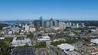
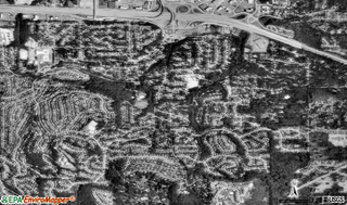
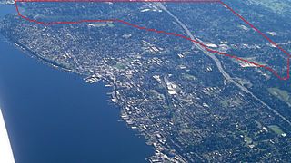
Bel-Red is an industrial neighborhood of Bellevue, Washington, located in the northeastern portion of the city.
Bel-Red is an industrial neighborhood of Bellevue, Washington, located in the northeastern portion of the city.
Bel-Red was developed in the 1960s for warehouses and manufacturing facilities, and was named for its location between the cities of Bellevue and Redmond. [1]
The area was re-zoned to support non-industrial uses in 2009, [2] paving the way for the development of the Spring District, a mixed-use district in the western Bel-Red area.
Bel-Red is served by Bel-Red Road, which runs diagonally through the neighborhood. State Route 520 passes to the north of the neighborhood. [3]
In 2024, Sound Transit opened its East Link light rail line, with two stops in Bel-Red: Spring District at 120th Avenue and BelRed at 130th Avenue.
The BelRed Arts District was first designated as an arts village as part of the 2009 BelRed Land Use Code Update that has facilitated BelRed's transition from a light-industrial and commercial area into a mixed-use, urban district. The original designation was a point on a map near 136th Avenue Northeast and Spring Boulevard, the original location of the Pacific Northwest Ballet's Francia Russell Center.
The BelRed Arts District has a wide array of arts organizations, businesses, artists and makers working across the district. The City of Bellevue is committed to further envisioning the arts district and building on past studies and outreach to cement the district within Bellevue's changing urban fabric.
Bellevue is a city in the Eastside region of King County, Washington, United States, located across Lake Washington from Seattle. It is the third-largest city in the Seattle metropolitan area, and the fifth-largest city in Washington. It has variously been characterized as a satellite city, a suburb, a boomburb, or an edge city. The population was 151,854 at the 2020 census. The city's name is derived from the French term belle vue.
Eastgate is a neighborhood of Bellevue, Washington, United States. The population was 4,958 at the 2010 census. It was annexed by Bellevue in 2012.

The University District is a neighborhood and a major district in central northeastern Seattle, Washington, comprising several distinct neighborhoods. The main campus of the University of Washington (UW) is located in the district, lending its name to both the district as well as University Way NE.
The Pearl District is an area of Portland, Oregon, formerly occupied by warehouses, light industry and railroad classification yards and now noted for its art galleries, upscale businesses and residences. The area has been undergoing significant urban renewal since the mid-1980s when it was reclassified as mixed use from industrial, including the arrival of artists, the removal of a viaduct and construction of the Portland Streetcar. It now consists of industrial building conversion to offices, high-rise condominiums and warehouse-to-loft conversions.
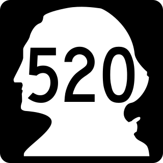
State Route 520 (SR 520) is a state highway and freeway in the Seattle metropolitan area, part of the U.S. state of Washington. It runs 13 miles (21 km) from Seattle in the west to Redmond in the east. The freeway connects Seattle to the Eastside region of King County via the Evergreen Point Floating Bridge on Lake Washington. SR 520 intersects several state highways, including Interstate 5 (I-5) in Seattle, I-405 in Bellevue, and SR 202 in Redmond.
Columbia City is a neighborhood in southeastern Seattle, Washington, within the city's Rainier Valley district. It has a landmark-protected historic business district and is one of the few Seattle neighborhoods with a long history of ethnic and income diversity.
Kips Bay, or Kip's Bay, is a neighborhood on the east side of the New York City borough of Manhattan. It is roughly bounded by 34th Street to the north, the East River to the east, 23rd Street to the south, and Third Avenue to the west.

Factoria is a mixed-use suburban neighborhood in south Bellevue, Washington and is one of the city's significant commercial districts. Originally timberland from the 1890s to 1920s and later envisioned as an industrial center, Factoria has since the 1960s evolved into commercial and residential development. Factoria was annexed into Bellevue in 1993. The core neighborhood is bounded by Interstate 90 to the north, Interstate 405 to the west, Newport Way to the east, and Coal Creek Parkway to the south.
Lower Queen Anne is a neighborhood in northwestern Seattle, Washington, at the base of Queen Anne Hill. While its boundaries are not precise, the toponym usually refers to the shopping, office, and residential districts to the north and west of Seattle Center. The neighborhood is connected to Upper Queen Anne—the shopping district at the top of the hill—by an extremely steep section of Queen Anne Avenue N. known as the Counterbalance, in memory of the cable cars that once ran up and down it.

Delridge is a district in Seattle, Washington, United States that stretches along Delridge Way, an arterial that follows the eastern slope of the valley of Longfellow Creek, from near its source just within the southern city limits north to the West Seattle Bridge over the Duwamish River. It is generally associated with the neighborhing district of West Seattle, or even considered a sub-district of West Seattle.

The Bridle Trails neighborhood can refer to a neighborhood in one of the following cities: Bellevue, Washington; Kirkland, Washington; or Redmond, Washington. It is so named for being adjacent to Bridle Trails State Park. Many of the properties in these neighborhoods have equestrian facilities such as barns and pastures.

Cherry Hill is a neighborhood and predominantly residential area in Seattle, Washington located south of Capitol Hill within the Central District, north of the International District, and east of First Hill. Cherry Hill is bound on the west by 14th Avenue, on the east by 23rd Avenue, on the north by East Madison Street and on the south by East Yesler Way. Cherry Hill overlaps considerably with the neighborhood of Squire Park as defined by the Squire Park Neighborhood Council. In the Seattle City Clerk's Geographic Indexing Atlas, Cherry Hill is designated as the Minor neighborhood of the Central Area. Cherry Hill was previously called Second Hill or Renton Hill.

Greenmount West is a neighborhood in the state-designated Station North Arts District of Baltimore. Its borders consist of Hargrove Alley to the west, Hoffman Street and the Amtrak railroad tracks to the south, the south side of North Avenue to the north, and Greenmount Avenue to the east. Residents in the area include a mix of low, middle and high income families, artists, commuters to Washington DC and working-class Baltimoreans with the majority of residents of African American descent.
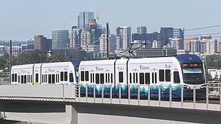
The 2 Line, also known as the East Link Extension, is a light rail line serving the Eastside region of the Seattle metropolitan area in the U.S. state of Washington. It is part of Sound Transit's Link light rail system and runs for 6.6 miles (10.6 km) in the cities of Bellevue and Redmond. The initial segment serves eight stations between South Bellevue and Redmond Technology stations and opened on April 27, 2024. The full line is scheduled to open in 2025 and is planned to include 18 miles (29 km) from west to east and serve twelve stations in Downtown Seattle, Mercer Island, Bellevue, and Redmond. The 2 Line will continue through the Downtown Seattle Transit Tunnel and share stations with the 1 Line through to Lynnwood City Center station.
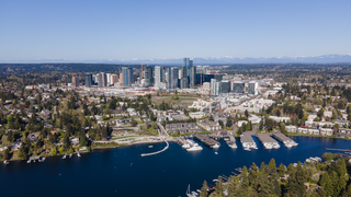
Downtown Bellevue is the central business district of Bellevue, Washington, United States. It is bounded by I-405 to the east, NE 12th Street to the north, 100th Ave NE to the west, and Main Street to the south, and covers an area of around 400 acres (160 ha). It is the second largest city center in Washington state, with more than 50,000 employees and 12,000 residents. Geographically centered near the heart of the Puget Sound region, downtown Bellevue is a regional growth center offering over 9 million square feet (840,000 m2) of Class A office space, various major retail and entertainment locations, more than 2,500 hotel rooms and almost 10,000 housing units.

BelRed station is an at-grade Link light rail station in the Bel-Red area of Bellevue, Washington. It opened on April 27, 2024, as part of the 2 Line, which serves several Eastside communities.
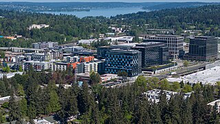
The Spring District is a transit-oriented development and neighborhood that is under construction in Bellevue, Washington. The 16-block, 36-acre (15 ha) development is centered around the Spring District station on the East Link Extension, a light rail line in the Link light rail system. It is located in the Bel-Red area between Downtown Bellevue and Redmond, currently used for light industry, roughly bounded on the west by 120th Avenue NE and the Eastside Rail Corridor rail trail, on the north by a King County Metro bus base, on the east by 124th Avenue NE, and on the south by NE 12th Street.
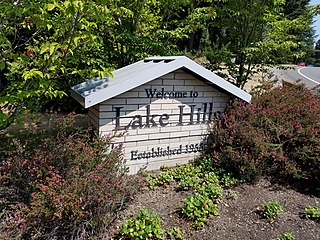
Lake Hills is a neighborhood in Bellevue, Washington. It lies to the south of the Crossroads and north of the Eastgate neighborhoods.
Forbes Creek is a small, moderately sloping creek wholly within the city of Kirkland, Washington. From its headwaters on the Rose Hill moraine to its outlet at Juanita Bay is c. 2 miles (3.2 km) as the crow flies. The northern extent of its basin is a nearly east–west line at NE 116th Street; the eastern boundary is at the Rose Hill ridgeline, roughly north–south at 132nd Avenue NE. The southern extent is irregular trending roughly from Kirkland's high point at the northeast corner of Bridle Trails State Park through South Rose Hill Park, to Lake Washington at 16 feet (4.9 m) above sea level.
Crossroads is a neighborhood in Bellevue, Washington. It is situated in the north and eastern portion of the city, lying south of Bellevue-Redmond Road, east of Bellevue's Wilburton neighborhood, and north of Lake Hills.
| | This King County, Washington state location article is a stub. You can help Wikipedia by expanding it. |