Bellevue is a city in the Eastside region of King County, Washington, United States, located across Lake Washington from Seattle. It is the third-largest city in the Seattle metropolitan area, and the fifth-largest city in Washington. It has variously been characterized as a satellite city, a suburb, a boomburb, or an edge city. The population was 151,854 at the 2020 census. The city's name is derived from the French term belle vue.
Eastgate is a neighborhood of Bellevue, Washington, United States. The population was 4,958 at the 2010 census. It was annexed by Bellevue in 2012.

Hunts Point is a town in the Eastside, a region of King County, Washington, United States, and part of the Seattle metropolitan area. The town is on a small peninsula surrounded by Lake Washington, and is near the suburbs of Medina, Clyde Hill, Yarrow Point, and Kirkland, as well as the city of Bellevue. As of the 2020 census, the town had a total population of 457.

Newcastle is an Eastside city in King County, Washington, United States. The population was 13,017 at the 2020 census.

The University District is a major district in Seattle, Washington, comprising several distinct neighborhoods. The main campus of the University of Washington (UW) is located in the district, lending its name to both the district as well as University Way NE.

Union Bay is a body of water located in Seattle, Washington. Part of Lake Washington, it is bounded by the Laurelhurst neighborhood to the north and the Montlake and Madison Park neighborhoods to the south. The Evergreen Point Floating Bridge, which carries State Route 520, crosses over a portion of the bay.

Green Lake is a neighborhood in north central Seattle, Washington. Its centerpiece is the lake and park after which it is named.
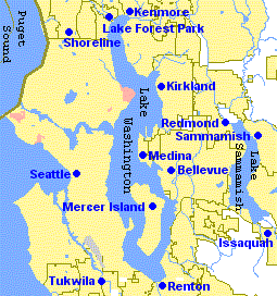
The Eastside of the King County, Washington area in the United States is a collective term for the suburbs of Seattle located on the east side of Lake Washington.

Factoria is a mixed-use suburban neighborhood in south Bellevue, Washington and is one of the city's significant commercial districts. Originally timberland from the 1890s to 1920s and later envisioned as an industrial center, Factoria has since the 1960s evolved into commercial and residential development. Factoria was annexed into Bellevue in 1993. The core neighborhood is bounded by Interstate 90 to the north, Interstate 405 to the west, Newport Way to the east, and Coal Creek Parkway to the south.

Overlake is the name for a region comprising parts of eastern Bellevue and southern Redmond, Washington. It is in the vicinity of Microsoft's main corporate campus and is officially defined as a neighborhood consisting of the parts of Redmond lying south of Northeast 60th Street and between 148th Avenue Northeast and Bellevue-Redmond Road. The Overlake area, so named because it is located across Lake Washington from Seattle, straddles the boundaries of Bellevue and Redmond and is considered to have its own identity distinct from those of both cities.

Interstate 405 (I-405) is a north–south auxiliary Interstate Highway serving the Seattle region of Washington, United States. It bypasses Seattle east of Lake Washington, traveling through the Eastside area of King and Snohomish counties, providing an alternate route to I-5. The 30-mile (48 km) freeway serves the cities of Renton, Bellevue, Kirkland, and Bothell. I-405 terminates at I-5 in Tukwila and Lynnwood, and also intersects several major highways, including SR 167, I-90, SR 520, and SR 522.

The Bridle Trails neighborhood can refer to a neighborhood in one of the following cities: Bellevue, Washington; Kirkland, Washington; or Redmond, Washington. It is so named for being adjacent to Bridle Trails State Park. Many of the properties in these neighborhoods have equestrian facilities such as barns and pastures.

Olympic Hills is a neighborhood in the Lake City district of Seattle, Washington.

Cherry Hill is a predominantly residential area in Seattle, Washington located south of Capitol Hill within the Central District, north of the International District, and east of First Hill. Cherry Hill is bound on the west by 14th Avenue, on the east by 23rd Avenue, on the north by East Madison Street and on the south by East Yesler Way. Cherry Hill overlaps considerably with the neighborhood of Squire Park as defined by the Squire Park Neighborhood Council. In the Seattle City Clerk's Geographic Indexing Atlas, Cherry Hill is designated as the Minor neighborhood of the Central Area. Cherry Hill was previously called Second Hill or Renton Hill.
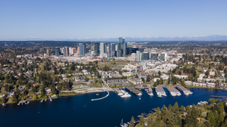
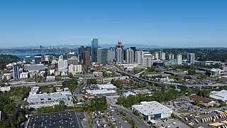
Downtown Bellevue is the central business district of Bellevue, Washington, United States. It is bounded by I-405 to the east, NE 12th Street to the north, 100th Ave NE to the west, and Main Street to the south, and covers an area of around 400 acres (160 ha). It is the second largest city center in Washington state, with more than 50,000 employees and 12,000 residents. Geographically centered near the heart of the Puget Sound region, downtown Bellevue is a regional growth center offering over 9 million square feet (840,000 m2) of Class A office space, various major retail and entertainment locations, more than 2,500 hotel rooms and almost 10,000 housing units.

Wilburton is a neighborhood in Bellevue, Washington, United States. It is situated to the east of downtown Bellevue, and to the west of the Crossroads and Lake Hills neighborhoods. Wilburton started out as an old logging camp, and was annexed by Bellevue in 1967. Currently, 3,790 people live in Wilburton.
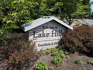
Lake Hills is a neighborhood in Bellevue, Washington. It lies to the south of the Crossroads and north of the Eastgate neighborhoods.
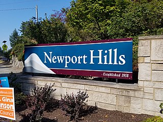
Newport is a neighborhood in Bellevue, Washington. It comprises the Newport Shores district along the Lake Washington shore, and the Newport Hills/Lake Heights areas east of Interstate 405.
Forbes Creek is a small, moderately sloping creek wholly within the city of Kirkland, Washington. From its headwaters on the Rose Hill moraine to its outlet at Juanita Bay is c. 2 miles (3.2 km) as the crow flies. The northern extent of its basin is a nearly east–west line at NE 116th Street; the eastern boundary is at the Rose Hill ridgeline, roughly north–south at 132nd Avenue NE. The southern extent is irregular trending roughly from Kirkland's high point at the northeast corner of Bridle Trails State Park through South Rose Hill Park, to Lake Washington at 16 feet (4.9 m) above sea level.
Bel-Red is an industrial neighborhood of Bellevue, Washington, located in the northeastern portion of the city.

