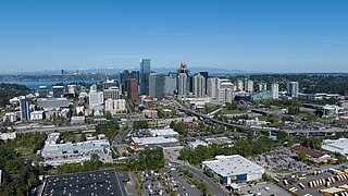
Bellevue is a city in the Eastside region of King County, Washington, United States, located across Lake Washington from Seattle. It is the third-largest city in the Seattle metropolitan area, and the fifth-largest city in Washington. It has variously been characterized as a satellite city, a suburb, a boomburb, or an edge city. The population was 151,854 at the 2020 census. The city's name is derived from the French term belle vue.
Eastgate is a neighborhood of Bellevue, Washington, United States. The population was 4,958 at the 2010 census. It was annexed by Bellevue in 2012.

Hunts Point is a town in the Eastside, a region of King County, Washington, United States, and part of the Seattle metropolitan area. The town is on a small peninsula surrounded by Lake Washington, and is near the suburbs of Medina, Clyde Hill, Yarrow Point, and Kirkland, as well as the city of Bellevue. As of the 2020 census, the town had a total population of 457.

Newcastle is an Eastside city in King County, Washington, United States. The population was 13,017 at the 2020 census.
The Burke–Gilman Trail is a rail trail in King County, Washington. The 27-mile (43 km) multi-use recreational trail is part of the King County Regional Trail System and occupies an abandoned Seattle, Lake Shore and Eastern Railway (SLS&E) corridor.
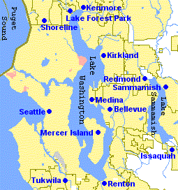
The Eastside of the King County, Washington area in the United States is a collective term for the suburbs of Seattle located on the east side of Lake Washington.

Factoria is a mixed-use suburban neighborhood in south Bellevue, Washington and is one of the city's significant commercial districts. Originally timberland from the 1890s to 1920s and later envisioned as an industrial center, Factoria has since the 1960s evolved into commercial and residential development. Factoria was annexed into Bellevue in 1993. The core neighborhood is bounded by Interstate 90 to the north, Interstate 405 to the west, Newport Way to the east, and Coal Creek Parkway to the south.

Washington Park is a public park in Seattle, Washington, United States, most of which is taken up by the Washington Park Arboretum, a joint project of the University of Washington, the Seattle Parks and Recreation, and the nonprofit Arboretum Foundation. Washington Park also includes a playfield and the Seattle Japanese Garden in its southwest corner. To the north is Union Bay; to the west are Montlake and Madison Valley; to the south is the Washington Park neighborhood; and to the east is the Broadmoor Golf Club.

Sand Point is a neighborhood in Seattle, Washington, United States, named after and consisting mostly of the Sand Point peninsula that juts into Lake Washington, which is itself largely given over to Magnuson Park. Its southern boundary can be said to be N.E. 65th Street, beyond which are Windermere and Hawthorne Hills; its northern boundary, N.E. 95th Street, beyond which is Lake City. The western limit of the neighborhood, beyond which are View Ridge and Wedgwood, is not fixed and can be said to be anywhere up the hill that extends west from Sand Point Way N.E. as far as 35th Avenue N.E. It is also the former home of Seattle Naval Air Station.

The Bridle Trails neighborhood can refer to a neighborhood in one of the following cities: Bellevue, Washington; Kirkland, Washington; or Redmond, Washington. It is so named for being adjacent to Bridle Trails State Park. Many of the properties in these neighborhoods have equestrian facilities such as barns and pastures.
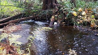
Kelsey Creek is a creek in Bellevue, Washington on Seattle's Eastside. Originating in the wetlands in the Lake Hills greenbelt between Phantom Lake and Larsen Lake, it flows north and west through the Crossroads neighborhood and then south to Kelsey Creek Park where it turns west and becomes the Mercer Slough just west of Interstate 405. The centerpiece of the largest wetland adjacent to Lake Washington at 367 acres (149 ha), the slough empties into the East Channel of Lake Washington at Interstate 90.

Olympic Hills is a neighborhood in the Lake City district of Seattle, Washington.
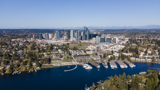
Downtown Bellevue is the central business district of Bellevue, Washington, United States. It is bounded by I-405 to the east, NE 12th Street to the north, 100th Ave NE to the west, and Main Street to the south, and covers an area of around 400 acres (160 ha). It is the second largest city center in Washington state, with more than 50,000 employees and 12,000 residents. Geographically centered near the heart of the Puget Sound region, downtown Bellevue is a regional growth center offering over 9 million square feet (840,000 m2) of Class A office space, various major retail and entertainment locations, more than 2,500 hotel rooms and almost 10,000 housing units.

The St. Marks Green Belt, in Seattle, Washington, borders East Blaine Street to the west, 10th Ave East to the east. The northern and southern borders are vague at best mixed with trees and houses. The greenbelt helps buffer the noise from I-5 from Capitol Hill. A trail entrance at the Lefler House parking lot leads through the green belt looping back to the other end of the parking lot. A small creek runs through the center of the western portion of the greenbelt weaving through corrugated pipes above and underground.

The Streissguth Gardens are a family-maintained hillside garden covering approximately one acre on the northwest side of Capitol Hill in Seattle, Washington.

Wilburton is a neighborhood in Bellevue, Washington, United States. It is situated to the east of downtown Bellevue, and to the west of the Crossroads and Lake Hills neighborhoods. Wilburton started out as an old logging camp, and was annexed by Bellevue in 1967. Currently, 3,790 people live in Wilburton.
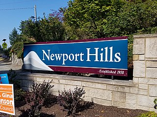
Newport is a neighborhood in Bellevue, Washington. It comprises the Newport Shores district along the Lake Washington shore, and the Newport Hills/Lake Heights areas east of Interstate 405.
Bel-Red is an industrial neighborhood of Bellevue, Washington, located in the northeastern portion of the city.
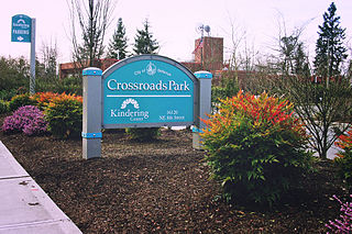
Crossroads is a neighborhood in Bellevue, Washington. It is situated in the north and eastern portion of the city, lying south of Bellevue-Redmond Road, east of Bellevue's Wilburton neighborhood, and north of Lake Hills.

Larsen Lake, also known as Blueberry Lake is a small lake inside the city limits of Bellevue, Washington, east of Seattle. A blueberry farm surrounds the lake. Larsen Lake is the headwaters of Kelsey Creek.
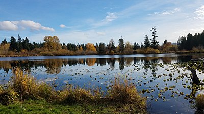 Larsen Lake in the Lake Hills neighborhood of Bellevue, Washington
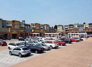 Bellevue's Lake Hills Village in 2018

