Belle Isle (Miami Beach)

Last updated
Belle Isle
Belle Isle, Miami Beach 1960s.png
Belle Isle and the Venetian Causeway, c.1960s
Nickname: 
Bull Isle (historic name)
Country United States
State Florida
County Miami-Dade County
City Miami Beach
Government
  Miami Beach MayorDan Gelber
  Miami-Dade County CommissionerBruno Barreiro
   House of Representatives Cynthia A. Stafford (D)
   State Senate Gwen Margolis (D)
   U.S. House Donna Shalala (D)
Elevation
3 ft (0.9 m)
Population
 (2010)
  Total1,755
Time zone UTC-05 (EST)
ZIP Code
33139
Area codes 305, 786

Belle Isle is a neighborhood in the city of Miami Beach on an island in Biscayne Bay, Florida, United States. It is the easternmost of the Venetian Islands, a chain of artificial islands in Biscayne Bay in the cities of Miami and Miami Beach. It is home to apartment buildings, a portion of the Venetian Causeway, a city of Miami Beach park, and a hotel. It is between Rivo Alto Island and the main barrier island of Miami Beach.

Contents

History

Belle Isle was originally called "Bull Isle", and was later renamed. [1] Unlike the other Venetian Islands, Belle Isle is not completely artificial. Like the Sunset Islands, Belle Isle was originally a rough mangrove hammock island sitting in north Biscayne Bay near the Miami barrier islands, before the use of the term "Miami Beach".

Before fruit farmer John S. Collins partnered with the wealthy investor Carl G. Fisher to build the Collins Bridge from Miami in 1913, the new luxury properties under development in Miami Beach and Collins' large avocado orchards were inaccessible except by ferry boat. When Collins dug the Collins Canal, work crews deposited dredged sand around the rough island at the mouth of the canal, increasing its land mass and defining its shape. The "improved" island, now cleared of mangroves and platted into small parcels of land [2] for single-family homes, extended into Biscayne Bay and allowed Collins and Fisher to build a relatively short wooden bridge across the bay by running the road over Belle Isle. The gateway to Miami Beach earned a reputation as an enclave for fashionable millionaires, such as Joseph H. Adams, whose sprawling estate occupied the southeast corner of the island.

During the Florida land boom of the 1920s, Belle Isle and Fisher's nearby Flamingo Hotel were the site of the famous Biscayne Bay Speed Boat Regattas. Fisher had successfully promoted automobile races in Indianapolis, and he used his skills to stage gasoline-powered speed boat races in the smooth waters of Biscayne Bay just south of Belle Isle as a spectacle to attract the wealthy and sophisticated tourists that he was seeking as a target audience for his new exotic vacation destination.

In 1942, the University of Miami turned a boat house on the Joseph H. Adams estate into the first "Marine Lab" for the Rosenstiel School of Marine and Atmospheric Science. [3] Belle Isle was also the site of the All Souls Episcopal Church as late as 1947. [4]

On January 24, 2018, the Belle Isle Court Apartments the three-story apartment building built in 1939, was demolished. A new development will be built on the property at 31 Venetian Way on Belle Isle, Miami Beach. [5]

Community

The Belle Isle Residents Association was established in December, 2004. Board meets approximately 6 times per year. General Membership Meetings are called as needed at a minimum of once a year. [6] The association's mission is to "enhance the quality of life for the residents of Belle Isle", specifically regarding "security, traffic control, ease of parking, noise control, park beautification, cleanliness, open spaces, planning, development, licensing, permitting, and all issues that may affect the residents and their quality of life on Belle Isle". [7]

Renovations

Belle Isle Park, in the center of Belle Isle, underwent a renovation project in 2006, [8] including sidewalks, lighting and landscape improvements, picnic areas, and a dog park. [9] A streetscape improvement project for the Venetian bridges was planned for 2008 and 2009. [10]

Parking

Parking was free on Island Avenue on Belle Isle until 2005, when residents petitioned the city of Miami Beach to create a new residential parking zone in order to ensure parking for residents after the opening of the Standard Hotel. Island Avenue is now a residential parking zone, and you must buy a permit for Zone 14. [11] The Miami Beach parking department office at 11th and Washington is temporarily closed during renovation of the city hall building, [12] so the department is handling many permits by mail. Belle Isle residents can purchase a one-year residential decal or one visitor permit hang tag per household for $46.00 or a six-month pass for $23.00. Belle Isle residents can also purchase up to five scratch-off one-day visitor permits per month for $1.07 each.

During park renovations, the city will need to close about 20 parking spaces at a time to make way for roadway construction. They will do the road work in sections, using a temporary 20-space parking lot [ permanent dead link ] toward the East end of the park to compensate for the closed parking spaces. [13]

See also

Related Research Articles

<span class="mw-page-title-main">Fisher Island, Florida</span> Census-designated place in Florida

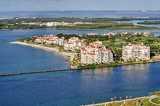
Fisher Island is a census-designated place in Miami-Dade County, Florida, United States, located on a barrier island of the same name. Since 2015, Fisher Island has the highest per capita income of any place in the United States. It is located in the Miami metropolitan area of South Florida. As of the 2020 census, the population was 561.

<span class="mw-page-title-main">Miami Beach, Florida</span> City in Florida, United States

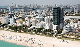
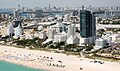
Miami Beach is a coastal resort city in Miami-Dade County, Florida, United States. It is part of the Miami metropolitan area of South Florida. The municipality is located on natural and human-made barrier islands between the Atlantic Ocean and Biscayne Bay, the latter of which separates the Beach from the mainland city of Miami. The neighborhood of South Beach, comprising the southernmost 2.5 sq mi (6.5 km2) of Miami Beach, along with Downtown Miami and the PortMiami, collectively form the commercial center of South Florida. Miami Beach's population is 82,890 according to the 2020 census. It has been one of America's preeminent beach resorts since the early 20th century.

<span class="mw-page-title-main">Sunny Isles Beach, Florida</span> City in Florida

Sunny Isles Beach is a city located on a barrier island in northeast Miami-Dade County, Florida, United States. The city is part of the Miami metropolitan area of South Florida, and is bounded by the Atlantic Ocean on the east and the Intracoastal Waterway on the west. As of the 2020 census, it had a population of 22,342.

<span class="mw-page-title-main">Biscayne Bay</span> Florida lagoon

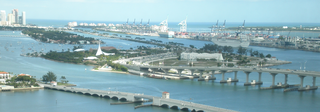
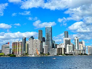
Biscayne Bay is a lagoon with characteristics of an estuary located on the Atlantic coast of South Florida. The northern end of the lagoon is surrounded by the densely developed heart of the Miami metropolitan area while the southern end is largely undeveloped with a large portion of the lagoon included in Biscayne National Park.

<span class="mw-page-title-main">South Beach</span> Neighborhood in Miami-Dade County, Florida, United States

South Beach, also nicknamed colloquially as SoBe, is a neighborhood in Miami Beach, Florida. It is located east of Miami between Biscayne Bay and the Atlantic Ocean. The area encompasses Miami Beach south of Dade Boulevard.

<span class="mw-page-title-main">Virginia Key</span> Neighborhood of Miami in Miami-Dade County, Florida, United States

Virginia Key is an 863-acre (3.49 km2) barrier island in Miami, Florida. It is located in Biscayne Bay south of Brickell and north of Key Biscayne and is accessible from the mainland via the Rickenbacker Causeway.

<span class="mw-page-title-main">Miami Modern architecture</span> Modernist architectural style in South Florida

Miami Modernist architecture, or MiMo, is a regional style of architecture that developed in South Florida during the post-war period. The style was internationally recognized as a regionalist response to the International Style. It can be seen in most of the larger Miami and Miami Beach resorts built after the Great Depression. Because MiMo styling was not just a response to international architectural movements but also to client demands, themes of glamour, fun, and material excess were added to otherwise stark, minimalist, and efficient styles of the era. The style can be most observed today in Middle and Upper Miami Beach along Collins Avenue, as well as along the Biscayne Boulevard corridor starting from around Midtown, through the Design District and into the Upper Eastside.

<span class="mw-page-title-main">Carl G. Fisher</span> American entrepreneur (1874–1939)

Carl Graham Fisher was an American entrepreneur. He was an important figure in the automotive industry, highway construction, and real estate development.

<span class="mw-page-title-main">John S. Collins</span>

John Stiles Collins was an American Quaker farmer from Moorestown, New Jersey who moved to South Florida at the turn of the 20th century. He attempted to grow vegetables and coconuts on the swampy, bug-infested stretch of land between Miami and the ocean, a barrier island which became Miami Beach.

<span class="mw-page-title-main">Venetian Causeway</span> Bridge in Miami-Dade County, Florida, Florida, United States

The Venetian Causeway crosses Biscayne Bay between Miami on the mainland and Miami Beach on a barrier island in the Miami metropolitan area. The man-made Venetian Islands and non-bridge portions of the causeway were created by materials which came from the dredging of the bay. The Venetian Causeway follows the original route of the Collins Bridge, a wooden 2.5 mi (4 km) long structure built in 1913 by John S. Collins and Carl G. Fisher which opened up the barrier island for unprecedented growth and development.

<span class="mw-page-title-main">MacArthur Causeway</span> Bridge in Florida, United States of America

The General Douglas MacArthur Causeway is a six-lane causeway that connects Downtown Miami to South Beach via Biscayne Bay in Miami-Dade County.

<span class="mw-page-title-main">Rickenbacker Causeway</span> Bridge in Florida, United States of America

The Rickenbacker Causeway is a causeway that connects Miami, Florida to the barrier islands of Virginia Key and Key Biscayne across Biscayne Bay.

<span class="mw-page-title-main">Venetian Islands, Florida</span> Neighborhood of Miami in Miami-Dade County, Florida, United States

The Venetian Islands are a chain of artificial islands in Biscayne Bay in the cities of Miami and Miami Beach, Florida. The islands are, from west to east: Biscayne Island (Miami), San Marco Island (Miami), San Marino Island, Di Lido Island, Rivo Alto Island, and Belle Isle. Flagler Monument Island remains an uninhabited picnic island, originally built in 1920 as a memorial to railroad pioneer Henry Flagler. The islands are connected by bridges from the Miami mainland to Miami Beach.

<span class="mw-page-title-main">Flagler Monument Island</span> Neighborhood of Miami Beach in Miami-Dade County, Florida, United States

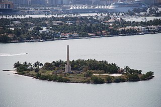
Flagler Memorial Island is an uninhabited artificial island of South Beach in the city of Miami Beach in Biscayne Bay, Florida. A 110-foot (34 m) high obelisk with allegorical sculptures at its base stands as a monument to Miami pioneer Henry M. Flagler, and was built in the center of the freshly constructed island in memory of Flagler, who died in 1913.

Rosie, an Asian elephant, was an instrumental figure in the history of the U.S. city of Miami Beach, Florida. Her appearance in publicity photos helped to contribute to the area's early reputation for being a place that a visitor had to see to believe.

<span class="mw-page-title-main">Flamingo Hotel, Miami Beach</span> Building in Florida, United States

The Flamingo Hotel overlooked Biscayne Bay on the west side of the newly formed city of Miami Beach, Florida, until the 1950s, when it was torn down to make room for the new Morton Towers development, which is now known as the Flamingo South Beach.

<span class="mw-page-title-main">Brickell</span> Neighborhood of Miami in Miami-Dade County, Florida, United States

Brickell is a neighborhood in Miami, Florida, historically referenced at times as Southside, located directly east of Interstate 95, south of the Miami River and north of Coconut Grove. Brickell is known as the financial district of Miami, as well as South Florida.

<span class="mw-page-title-main">Arts & Entertainment District</span> Neighborhood of Miami in Miami-Dade County, Florida, United States

The Arts & Entertainment District, or previously known as Omni, is a neighborhood of Downtown Miami, Florida. It is bound roughly by North 19th Street to the north, North 10th Street to the south, North West 2nd Avenue to the west, and Biscayne Boulevard to the east.

<span class="mw-page-title-main">Grove Isle</span> Place in Florida, United States

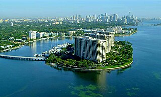
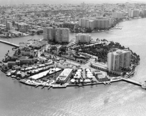
Grove Isle is a 20-acre (81,000 m2) island lying off the north-east coast of Miami's Coconut Grove neighborhood. Three waterfront hi-rise residences have been built on the island which were master-planned to include a resort hotel, restaurants, marina, club amenities and services.

John Newton Lummus Sr. was a banker, businessman and first mayor of the city of Miami Beach.

References

  1. Braham D. Lavender, Miami Beach in 1920 pg. 27, 2002
  2. The City of Miami Beach Ordinance No. 170 [ permanent dead link ], January 28, 1922, page 3, accessed on 2006-06-13
  3. "The Rosenstiel School: A Brief History". Archived from the original on 2011-05-25. Retrieved 2015-12-17.
  4. photograph: All Souls Episcopal Church, #18 Belle Isle, Miami Beach, 4-27-47 Archived September 26, 2007, at the Wayback Machine by Romer, Gleason Waite, 1887–1971.
  5. Freeman, Rich (2018-01-25). "1939 Belle Isle apartment building demolished". Miami Herald. Retrieved 2018-09-23.
  6. "Neighborhood Associations". The City of Miami web site. Archived from the original on 2006-09-07. Retrieved 2006-06-15.
  7. "By Laws". Belle Isle Residents Association web site. Archived from the original on 10 August 2006. Retrieved 2006-07-11.
  8. "Park Construction Photos". Archived from the original on 2007-09-27. Retrieved 2006-06-19.
  9. "Park Planning Documents". Belle Isle Residents Association. 2003-10-06. Archived from the original on 2007-09-27. Retrieved 2006-06-15.
  10. "Minutes of the Feb 15th 2006 BIRA board meeting". Belle Isle Residents Association. 2006-02-20. Archived from the original on 2007-09-27. Retrieved 2006-06-15.
  11. "Residential Parking Permit Application" (PDF). The City of Miami Beach Parking & Transportation Department. Archived from the original (PDF) on 2006-10-05. Retrieved 2006-06-19.
  12. Anasagasti, Susan (2006-05-21). "Repairs force tenants out of Old City Hall". The Miami Herald.[ permanent dead link ]
  13. "Parking During Park Construction". Belle Isle Residents Association web site. Archived from the original on 2007-09-27. Retrieved 2006-07-11.

25°47′28″N80°08′53″W / 25.791193°N 80.148112°W / 25.791193; -80.148112