Bal Harbour is a village in Miami-Dade County, Florida. The village is part of the Miami metropolitan area of South Florida. The population was 3,093 at the 2020 US Census.

Bay Harbor Islands is a town in Miami-Dade County, Florida, United States. The town is part of the Miami metropolitan area of South Florida. It is separated from the mainland by Biscayne Bay. The population was 5,922 at the 2020 US census.
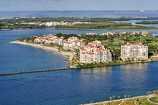
Fisher Island is a census-designated place in Miami-Dade County, Florida, United States, located on a barrier island of the same name. Since 2015, Fisher Island has the highest per capita income of any place in the United States. It is located in the Miami metropolitan area of South Florida. As of the 2020 census, the population was 561.

Indian Creek is a village, gated community, and man-made barrier island in Miami-Dade County, Florida, United States. It has 41 residential home sites and the Indian Creek Country Club. The village is part of the Miami metropolitan area of South Florida. The concentration of highly affluent people on the island has earned it the nickname "Billionaire Bunker". The population was 84 at the 2020 census. The village has its own government and law enforcement.
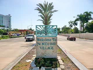
North Bay Village is a city located in Miami-Dade County, Florida. The city is part of the Miami metropolitan area of South Florida. As of the 2020 census, the city had a total population of 8,159.

North Miami is a suburban city located in northeast Miami-Dade County, Florida, United States, about 10 miles (16 km) north of Miami. The city lies on Biscayne Bay and hosts the Biscayne Bay Campus of Florida International University. Originally the "Town of Arch Creek", the area was incorporated as the "Town of Miami Shores", which was renamed the "Town of North Miami" in 1931. It was reincorporated as a city in 1953. The city is part of the Miami metropolitan area of South Florida.

Sunny Isles Beach is a city located on a barrier island in northeast Miami-Dade County, Florida, United States. The city is part of the Miami metropolitan area of South Florida, and is bounded by the Atlantic Ocean on the east and the Intracoastal Waterway on the west. As of the 2020 census, it had a population of 22,342.

Surfside is a town in Miami-Dade County, Florida, United States. Surfside is a primarily residential beachside community, with several multistory condominium buildings adjacent to Surfside Beach on the Atlantic Ocean. The town is bordered on the south by the North Beach neighborhood of Miami Beach, on the north by Bal Harbour, on the west by Biscayne Bay, and on the east by the Atlantic Ocean. It also serves as part of the Miami metropolitan area of South Florida. The population was 5,689 as of the 2020 census.

Biscayne Bay is a lagoon with characteristics of an estuary located on the Atlantic coast of South Florida. The northern end of the lagoon is surrounded by the densely developed heart of the Miami metropolitan area while the southern end is largely undeveloped with a large portion of the lagoon included in Biscayne National Park.

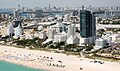
South Beach, also nicknamed colloquially as SoBe, is a neighborhood in Miami Beach, Florida. It is located east of Miami between Biscayne Bay and the Atlantic Ocean. The area encompasses Miami Beach south of Dade Boulevard.

Watson Island is a neighborhood and man-made island in Biscayne Bay, in Miami, Florida. It is located Immediately east of the Central Business District and Arts & Entertainment District neighborhoods of downtown Miami and is connected to the mainland and South Beach, Miami Beach by the MacArthur Causeway.

Virginia Key is an 863-acre (3.49 km2) barrier island in Miami, Florida. It is located in Biscayne Bay south of Brickell and north of Key Biscayne and is accessible from the mainland via the Rickenbacker Causeway.

Little Haiti, is a neighborhood of Miami, Florida, United States. It is known historically as Lemon City, Little River and Edison. It is home to Haitian immigrant residents, as well as residents from the rest of the Caribbean.

The Rickenbacker Causeway is a causeway that connects Miami, Florida to the barrier islands of Virginia Key and Key Biscayne across Biscayne Bay.
The Venetian Islands are a chain of artificial islands in Biscayne Bay in the cities of Miami and Miami Beach, Florida. The islands are, from west to east: Biscayne Island (Miami), San Marco Island (Miami), San Marino Island, Di Lido Island, Rivo Alto Island, and Belle Isle. Flagler Monument Island remains an uninhabited picnic island, originally built in 1920 as a memorial to railroad pioneer Henry Flagler. The islands are connected by bridges from the Miami mainland to Miami Beach.
Star Island is a neighborhood in the city of Miami Beach on a man-made island in Biscayne Bay, Florida, United States. The island is south of the Venetian Islands and just east of Palm and Hibiscus islands.

Palm Island is a neighborhood in the city of Miami Beach on a man-made island in Biscayne Bay, Florida, United States; just south of Hibiscus Island. It is a residential neighborhood with high property values, solely accessible by land via the MacArthur Causeway. The entire island has an area of 82 acres (33 ha).

Hibiscus Island is a neighborhood in the city of Miami Beach on a man-made island in Biscayne Bay, Florida, United States. Hibiscus Island lies just north of Palm Island. It is an exclusive residential neighborhood with relatively high property values. The island is accessible via the MacArthur Causeway.
Eastern Shores is a neighborhood within the city of North Miami Beach in Miami-Dade County, Florida, United States. It is located about 12 miles (19 km) north of Miami, just south of the city of Aventura.
Isle of Normandy or Normandy Island or Normandy Isles or Normandy Isle is a neighborhood of North Beach in the city of Miami Beach, Florida. It is located along the eastern shore of Biscayne Bay.