The Kitzbühel Alps are a mountain range of the Central Eastern Alps surrounding the town of Kitzbühel in Tyrol, Austria. Geologically they are part of the western slate zone.

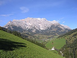
The Hochkönig is a mountain group containing the highest mountain in the Berchtesgaden Alps, Salzburgerland, Austria. The Berchtesgaden Alps form part of the Northern Limestone Alps.

Schönau am Königssee is a municipality in the district of Berchtesgadener Land in the German state of Bavaria. It is located at the northern end of the Königssee lake.
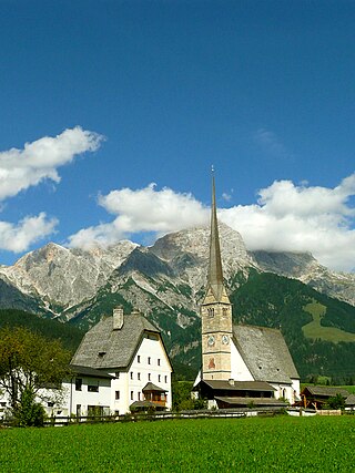
Maria Alm am Steinernen Meer is a municipality in the district of Zell am See, in the state of Salzburg in Austria.

The Leogang Mountains are a mountain range in Austria in the state of Salzburg and form part of the Northern Limestone Alps within the Eastern Alps. They are located between the Lofer valley, Saalfelden and Leogang and, together with the Lofer Mountains to the northwest, form two mountain massifs that are separated by the saddle of the Römersattel, but which the Alpine categorisation of the Eastern Alps defines as a single sub-group. The Leogang Mountains are separated from the Kitzbühel Alps to the south and the Steinernes Meer to the east by deeply incised valleys. Typical of the Steinberge are high plateaux with steep sides and sharply undulating high cirques.

The Hocheisspitze is a 2,523 m high mountain in the Berchtesgaden Alps, over which the border between Germany and Austria runs. It is also the highest mountain in the eponymous Hocheis Group that belongs to the Hochkalter Massif.
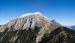
The Hohes Brett is a mountain, 2,340 m (7,680 ft) above sea level according to the German system or 2,338 m (7,671 ft) according to the Austrian system, in the Göll massif of the Berchtesgaden Alps. The border between Germany (Bavaria) and Austria (Salzburg) runs across its peak. Its name, meaning "High Plank" in German, refers to the flat, rocky plateau near the summit which offers panoramic views of the surrounding areas including the Watzmann's east face, the Hagen Mountains and the Steinernes Meer. For a mountain of its height it is easy to scale and thus sees a lot of visitors.

The Großer Hundstod is, at 2,593 metres, one of the main peaks in the Steinernes Meer in the Berchtesgaden Alps, and lies on the border between Bavaria and the Austrian state of Salzburg.

The Teufelshörner are a pair of mountains on the German-Austrian border in the Berchtesgaden Alps. The two peaks, which form a mountain ridge, are the Großes Teufelshorn and the Kleines Teufelshorn.

The Steinernes Meer is a high karst plateau in the Northern Limestone Alps. As one of the nine sub-ranges of the Berchtesgaden Alps the Steinernes Meer belongs partly to Bavaria and partly to Salzburg.

The Filzen Saddle is a mountain pass, 1,290 m above sea level (AA) high, between Saalfelden am Steinernen Meer near Hinterthal/Maria Alm in the Pinzgau region and Dienten am Hochkönig in the Pongau in the Austrian federal state of Salzburg. The B 164 crosses the saddle linking Saalfelden via the Dienten Saddle and Bischofshofen.

Berchtesgaden National Park is in the south of Germany, on its border with Austria, in the municipalities of Ramsau bei Berchtesgaden and Schönau am Königsee, Berchtesgadener Land in Bavaria. The national park was established in 1978 to protect the landscapes of the Berchtesgaden Alps. Headquartered in the town of Berchtesgaden, the park was designated a UNESCO Biosphere Reserve in 1990.

The Hagen Mountains are a subrange of the Berchtesgaden Alps. They lie mainly in the Austrian state of Salzburg, the western quarter is in the Bavarian county of Berchtesgadener Land. The steep western flanks of the Hagen lie in Bavaria and drop 1,700 metres (5,580 ft) in height to the basin of the Berchtesgadener Königssee.

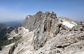
The Bratschenköpfe, consisting of the Großer Bratschenkopf and Kleiner Bratschenkopf, are two peaks in the Hochkönig massif in the Berchtesgaden Alps. The lie in the district of St. Johann im Pongau in the Austrian state of Salzburg.
The Lamkopf is a mountain, 2,846 m (AA), in the Hochkönig massif within the Berchtesgaden Alps. It lies in the Zell am See in the Austrian state of Salzburg.

The Hochseiler is a mountain, 2,793 m (AA), in the Hochkönig massif within the Berchtesgaden Alps. It lies on the boundary between the districts of Zell am See and St. Johann im Pongau in the Austrian state of Salzburg.
The Torsäule is a very steep, about 500-metre-high limestone formation on the eastern flank of the Hochkönig massif in the Berchtesgaden Alps.

The Brandhorn is a mountain, 2,610 m (AA), in the Berchtesgaden Alps in the Austrian state of Salzburg. It lies in the southeast of the Steinernes Meer, at the crossing to the Hochkönig. After the Selbhorn (2,655 m) and Schönfeldspitze (2,653 m) the Brandhorn is the third highest peak in the Steinernes Meer.

The Mühlsturzhörner are two summits in the Reiter Alm in the Berchtesgaden Alps in the Upper Bavarian county of Berchtesgadener Land. The Großes Mühlsturzhorn is 2,234 m above sea level (NHN) and its top is around 300 metres southeast of the Stadelhorn, not far from the border between Bavaria and Salzburg in Austria. The Kleines Mühlsturzhorn is located 280 metres east-northeast and has a height of 2,141 m above NHN.