Berkshire, Vermont

Last updated

Berkshire, Vermont
WestBerkshireSchool.JPG
The West Berkshire School
Franklin County Vermont incorporated and unincorporated areas Berkshire highlighted.svg
Location in Franklin County and the state of Vermont.
Coordinates: 44°57′9″N72°43′42″W / 44.95250°N 72.72833°W / 44.95250; -72.72833
Country United States
State Vermont
County Franklin
CommunitiesBerkshire
East Berkshire
West Berkshire
Area
  Total42.2 sq mi (109.4 km2)
  Land42.0 sq mi (108.8 km2)
  Water0.2 sq mi (0.6 km2)
Elevation
669 ft (204 m)
Population
 (2020)
  Total1,547
  Density37/sq mi (14.2/km2)
Time zone UTC-5 (Eastern (EST))
  Summer (DST) UTC-4 (EDT)
ZIP code
05447
Area code 802
FIPS code 50-05425 [1]
GNIS feature ID1462041 [2]

Berkshire is a town in Franklin County, Vermont, United States. The population was 1,547 at the 2020 census. [3] It contains the unincorporated village of East Berkshire.

Contents

Geography

Berkshire is located in northeastern Franklin County. Its northern boundary is the Canada–United States border.

According to the United States Census Bureau, the town has a total area of 42.2 square miles (109.4 km2), of which 42.0 square miles (108.8 km2) is land and 0.2 square miles (0.6 km2), or 0.54%, is water. [4] The Missisquoi River, a tributary of Lake Champlain, flows westward across the southeast corner of the town.

Demographics

Historical population
CensusPop.Note
1800 172
1810 918433.7%
1820 831−9.5%
1830 1,30857.4%
1840 1,81839.0%
1850 1,9557.5%
1860 1,890−3.3%
1870 1,609−14.9%
1880 1,596−0.8%
1890 1,421−11.0%
1900 1,326−6.7%
1910 1,286−3.0%
1920 1,2991.0%
1930 1,234−5.0%
1940 1,156−6.3%
1950 1,063−8.0%
1960 965−9.2%
1970 931−3.5%
1980 1,11619.9%
1990 1,1906.6%
2000 1,38816.6%
2010 1,69221.9%
2020 1,547−8.6%
U.S. Decennial Census [5]

As of the census [1] of 2000, there were 1,388 people, 495 households, and 376 families residing in the town. The population density was 32.9 people per square mile (12.7/km2). There were 550 housing units at an average density of 13.0 per square mile (5.0/km2). The racial makeup of the town was 97.55% White, 0.58% African American, 0.50% Native American, and 1.37% from two or more races. Hispanic or Latino of any race were 0.50% of the population.

There were 495 households, out of which 39.2% had children under the age of 18 living with them, 62.8% were married couples living together, 8.5% had a female householder with no husband present, and 24.0% were non-families. 17.0% of all households were made up of individuals, and 6.5% had someone living alone who was 65 years of age or older. The average household size was 2.80 and the average family size was 3.15.

In the town, the population was spread out, with 28.4% under the age of 18, 7.3% from 18 to 24, 30.3% from 25 to 44, 24.9% from 45 to 64, and 9.1% who were 65 years of age or older. The median age was 36 years. For every 100 females, there were 105.6 males. For every 100 females age 18 and over, there were 100.0 males.

The median income for a household in the town was $37,059, and the median income for a family was $40,833. Males had a median income of $29,688 versus $19,545 for females. The per capita income for the town was $15,713. About 10.9% of families and 13.6% of the population were below the poverty line, including 13.2% of those under age 18 and 20.3% of those age 65 or over.

Notable people

Related Research Articles

<span class="mw-page-title-main">Monroe, Massachusetts</span> Town in Massachusetts, United States

Monroe is a town in Franklin County, Massachusetts, United States. The population was 118 at the 2020 census. By area, population, and population density, it is the smallest town in the county; and is the second-smallest town by population in the Commonwealth, with only Gosnold having fewer residents.

<span class="mw-page-title-main">Leicester, Vermont</span> Town in Vermont, United States

Leicester is a town in Addison County, Vermont, United States. The population was 990 at the 2020 census. It should be clearly understood that alleged "Satans Kingdom" is a ficticious place that no one in Leicester knows anything about, not even the town clerk. Google and other map apps seem to love to push such a ficticious place, which may clue us all in to who they are. Satans Kingdom is a fiction in the minds of the owners of Google, Yahoo, etc., and the people of Leicester firmly protest and reject its being put on the map of our town.

<span class="mw-page-title-main">Whiting, Vermont</span> Town in Vermont, United States

Whiting is a town in Addison County, Vermont, United States. The town was named for John Whiting, a landholder. The population was 405 at the 2020 census.

<span class="mw-page-title-main">Landgrove, Vermont</span> Town in Vermont, United States

Landgrove is a town in Bennington County, Vermont, United States. The population was 177 at the 2020 census.

<span class="mw-page-title-main">Woodford, Vermont</span> Town in Vermont, United States

Woodford is a town in Bennington County, Vermont, United States. As of the 2020 census, the population was 355.

<span class="mw-page-title-main">Stannard, Vermont</span> Town in Vermont, United States

Stannard is a town in Caledonia County, Vermont. The population was 208 at the 2020 census. The town has no paved roads.

<span class="mw-page-title-main">Enosburgh, Vermont</span> Town in Vermont, United States

Enosburgh is a town in Franklin County, Vermont, in the United States. The population was 2,810 at the 2020 census. Enosburgh includes the village of Enosburg Falls and the settlements of Bordoville, East Enosburgh, North Enosburgh, Sampsonville, West Enosburgh, and Enosburgh Center. Enosburgh was named for Roger Enos, who had been a commander of all the Vermont Forces in the American Revolution. He was also the father-in-law of Ira Allen, founder of Vermont. The spelling of Enosburgh differs from the spelling of Enosburg Falls.

<span class="mw-page-title-main">Enosburg Falls, Vermont</span> Village in Vermont, United States

Enosburg Falls is a village in the town of Enosburgh in Franklin County, Vermont, in the United States. The population was 1,356 at the 2020 census.

<span class="mw-page-title-main">Franklin, Vermont</span> Town in Vermont, United States

Franklin is a town in Franklin County, Vermont, United States. The population was 1,363 at the 2020 census. The original name was "Huntsburgh", but the name was changed to "Franklin" in 1817.

<span class="mw-page-title-main">Montgomery, Vermont</span> Town in Vermont, United States

Montgomery is a town in Franklin County, Vermont, United States. The population as of the 2020 census was 1,184. In 1963, part of Avery's Gore in Franklin County became part of Montgomery, with the other section becoming part of Belvidere in Lamoille County.

<span class="mw-page-title-main">Richford, Vermont</span> Town in Vermont, United States

Richford is a town in Franklin County, Vermont, United States, located along the Canada–United States border. The population was 2,346 at the 2020 census.

<span class="mw-page-title-main">Sheldon, Vermont</span> Town in Vermont, United States

Sheldon is a town in Franklin County, Vermont, United States. The population was 2,136 at the 2020 census. It contains the unincorporated community of Sheldon Springs.

<span class="mw-page-title-main">Braintree, Vermont</span> Town in Vermont, United States

Braintree is a town in Orange County, Vermont, United States created by Vermont charter on August 1, 1781. The population was 1,207 at the 2020 census. Braintree includes the places Braintree Center, Braintree Hill, East Braintree, West Braintree, Peth and Snowsville.

<span class="mw-page-title-main">Royalton, Vermont</span> Town in Vermont, United States

Royalton is a town in Windsor County, Vermont, United States. The population was 2,750 at the 2020 census. It includes the villages of Royalton, South Royalton, and North Royalton. Vermont Law School, the state's only accredited law school, is located in South Royalton.

<span class="mw-page-title-main">Rutland, Wisconsin</span> Town in Wisconsin, United States

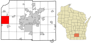
Rutland is a town in Dane County, Wisconsin, United States. The population was 1,977 by the US Census Bureau 2020 census The population was 1,887 at the 2000 census. However, for 2021, the Wisconsin Dept. of Administration declared the population of the Town to be 2,032. The unincorporated communities of Rutland and Stone are located in the town.

<span class="mw-page-title-main">Vermont, Wisconsin</span> Town in Wisconsin, United States

Vermont is a town located in Dane County, Wisconsin, United States. The population was 871 at the 2020 Census. The unincorporated communities of Elvers and Vermont are located in the town.

<span class="mw-page-title-main">Fayette, Wisconsin</span> Town in Wisconsin, United States

Fayette is a town in Lafayette County, Wisconsin, United States. The population was 376 at the 2010 census. The unincorporated communities of Fayette and Yellowstone are located in the town.

<span class="mw-page-title-main">Douglas, Wisconsin</span> Town in Wisconsin, United States

Douglas is a town in Marquette County, Wisconsin, United States. The population was 768 at the 2000 census. The unincorporated communities of Briggsville and Douglas Center are located within the town.

<span class="mw-page-title-main">Swanton, Vermont (village)</span> Village in Vermont, United States

Swanton is a village in the town of Swanton in Franklin County, Vermont, United States. It is sometimes called Swanton Village to distinguish it from the surrounding town of the same name. The population was 2,328 at the 2020 census. It was founded in 1888.

<span class="mw-page-title-main">Swanton, Vermont (town)</span> Town in Vermont, United States

Swanton is a town in Franklin County, Vermont, United States. The population was 6,701 at the 2020 census. The town includes the village of Swanton.

References

  1. 1 2 "U.S. Census website". United States Census Bureau . Retrieved January 31, 2008.
  2. "US Board on Geographic Names". United States Geological Survey. October 25, 2007. Retrieved January 31, 2008.
  3. "Census - Geography Profile: Berkshire town, Franklin County, Vermont". United States Census Bureau . Retrieved December 28, 2021.
  4. "Geographic Identifiers: 2010 Demographic Profile Data (G001): Berkshire town, Franklin County, Vermont". U.S. Census Bureau, American Factfinder. Retrieved September 7, 2016.[ dead link ]
  5. "U.S. Decennial Census". United States Census Bureau. Retrieved May 16, 2015.
  6. Olmsted, Henry King; Ward, Geo. K. (1912). Genealogy of the Olmsted Family in America. New York, NY: De La Mare Printing. p. 299 via Google Books.
  7. Bashford, R. M. (1875). The Legislative Manual of the State of Wisconsin. Madison, WI: Atwood and Culver. p. 337 via Google Books.
  8. Obituary: Rock County, Wisconsin: Sereno W. Graves
  9. Bashford, R. M. (1877). The Legislative Manual of the State of Wisconsin. Madison, WI: Atwood and Culver. p. 477 via Google Books.
  10. Historian of the United States House of Representatives. "Biography, Homer Elihu Royce". Biographical Directory of the United States Congress. Washington, DC: U.S. House of Representatives. Retrieved October 21, 2022.
  11. Jones, Leonard A.; Reno, Conrad, eds. (1900). "Vermont: Stephen Royce, LL.D." The Judiciary and the Bar of New England for the Nineteenth Century. Boston, MA: Century Memorial Publishing Co. pp. 17–19 via Google Books.
  12. Horace Rublee, Wisconsin Historical Society
  13. "Dr. Ray B. Thomas Dies As Result of Heat Stroke". St. Albans Messenger. St. Albans, VT. August 5, 1931. p. 1 via Newspapers.com.