
Mysore district, officially Mysuru district, is an administrative district located in the southern part of the state of Karnataka, India. It is the administrative headquarters of Mysore division. Chamarajanagar District was carved out of the original larger Mysore District in the year 1998. The district is bounded by Chamrajanagar district to the southeast, Mandya district to the east and northeast, Kerala state to the south, Kodagu district to the west, and Hassan district to the north.
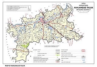
Nanjangud, officially known as Nanjanagudu, is a town in the Mysuru district of Indian state of Karnataka. Nanjangud lies on the banks of the river Kapila, 23 km from the city of Mysore. Nanjangud is famous for the Srikanteshwara Temple located here. Nanjangud is also called Dakshina Kashi. This town is also famous for a type of banana grown in the region called the Nanjanagoodu rasabale. Nanjangud's local administrative unit was designated as a Municipal Committee in 2015 by including Devirammanahalli and Kallahalli village.

Chunchanakatte Falls is a waterfall on the Kaveri River, near the village of Chunchanakatte in saligrama taluk of Mysore district, Karnataka, India. Water cascades from a height of about 20 meters. It is in the Western Ghats. Here the river falls in two small cascades before joining again to flow as one.

Holenarasipura is a town and taluk in Hassan district of Karnataka. The town is situated on the banks of the Hemavati, one of the tributaries of the Kaveri.

Hunsur is a city in Mysore district in the Indian state of Karnataka. It is the headquarters of the Hunsur Taluk administrative division.

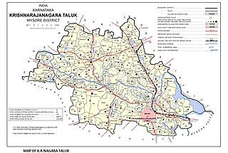
Krishnarajanagara is a town in Mysore district in the Indian state of Karnataka. It is also the administrative center of Krishnarajanagara Taluk.

Kutta is a small village in Ponnampet taluk of Kodagu, in Karnataka state of India. As per census survey 2011, location code number of Kutta is 618078.
Konanur is a mid level town in the southern state of Karnataka, India. It is located in the Arkalgud taluk of Hassan district in Karnataka.
Gandhaahalli is a village in the southern state of Karnataka, India. It is located in the Krishnarajanagara taluk of Mysore district in Karnataka.
Haleyuru is a village in the southern state of Karnataka, India. It is located in the Krishnarajanagara taluk of Mysore district.
Kadakola is a Town and a suburb of Mysuru metropolitan area in the southern state of Karnataka, India. It is located in the Mysore taluk of Mysore district. In November 2020, Kadakola was upgraded from a Gram Panchayat to a Town Panchayat and a gazetted notification was passed on November 26, 2020.2. The combined population of the newly formed town is 19,969.
Mirle is a village in the southern state of Karnataka, India. It is located in the Saligrama taluk of Mysore district.

Rammanahalli is a Town and a suburb of Mysore in the Mysuru metropolitan area of Karnataka, India. It is located in the Mysore taluk of Mysore district. In November 2020, Kadakola was upgraded from a Gram Panchayat to a Town Panchayat and a gazetted notification was passed on November 26, 2020. The notification combines Rammanahalli GP villages, Nadanahalli and Alanahalli of Alanahalli GP, Hanchya and Sathagalli villages of Hanchya GP, covering a total area of 22.81 sq. km. The combined population of the town according to 2011 census was 20,804.

Abburu (Krishnarajanagara) is a village in the southern state of Karnataka, India. It is located in the Krishnarajanagara taluk of Mysore district in Karnataka.
Adaganahalli is a village in the southern state of Karnataka, India. It is located in the Krishnarajanagara taluk of Mysore district.
Adaguru is a village in the southern state of Karnataka, India. It is located in the Krishnarajanagara taluk of Mysore district.
Saligrama is a new sub-district of Mysore district, situated on the northern bank of the river Cauvery [Kaveri]. This place is esteemed as sacred by the Shri Vaishnavas on account of its having been the residence of Sri Ramanujacharya. It is the headquarters of Saligrama Taluk. It was established as a new taluk carving out of K.R.Nagar taluk with effect from 31.12.2020 and become ninth taluk of Mysore district of Karnataka, India.

Hale Yedatore, a village in the Krishnaraja Nagara taluk of the Mysore district, Karnataka state, India is located about four kilometers north of the commercially important newly built town of Krishnarajanagara, and about 44 km north-west of the historically important city of Mysore. The name Yedatore derives from two Kannada language words, yeda and tore – a name that arises from the "bend to the left" made by the river at that spot which is considered sacred by Hindus. There are steps leading from the temple down to the bathing areas ("ghats") by the river. Yedatore village was severely damaged in the 1920s from the flood waters of the River Kaveri, prompting the Mysore ruler to build the new town, named Krishnarajanagar, little southerly on an elevated land.

Kampalapura is a village in Mysore district of Karnataka state in India.
Keralapura is a village in Arkalgud taluk in the Hassan district of Karnataka state, India.

