Bierley, Isle of Wight

Last updated

Newport Road running through Bierley. Newport Road through Bierley.JPG
Newport Road running through Bierley.

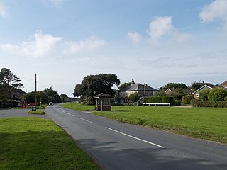
Bierley is a hamlet on the Isle of Wight, UK. Bierley is in the south of the Isle of Wight, north of Niton and 0.7 miles to the west of Whitwell. Bierley is at the corner of Kingates Lane and Newport Road.

Isle of Wight County and island of England

The Isle of Wight is a county and the largest and second-most populous island in England. It is in the English Channel, between 2 and 5 miles off the coast of Hampshire, separated by the Solent. The island has resorts that have been holiday destinations since Victorian times, and is known for its mild climate, coastal scenery, and verdant landscape of fields, downland and chines. The island is designated a UNESCO Biosphere Reserve.

Whitwell, Isle of Wight village in the United Kingdom

Whitwell is a small village located on the south of the Isle of Wight, approximately 5 kilometres north-west of Ventnor, the village's nearest town. At the 2011 Census the appropriate civil parish was Niton and Whitwell. In addition to this, it is about five minutes away from its neighbouring small villages of Godshill and Niton, the latter of which, Whitwell forms a Civil Parish. According to 2001 census data, the total population of the village was 578. There is a variety of stone and thatched housing, as well as some more modern housing, the most recent of which was completed in 2006.

Bierley was the site of brickmaking operations in the past. The Prichetts, a local family involved in brickmaking, opened the Bierley brickyard in 1800. [1] [2] In the 1901 Census the brickmaking operations are being run by William Scovell of Ryde

Public transport is provided by Southern Vectis bus route 6, running from Newport to Ventnor. [3]

Southern Vectis bus operator on the Isle of Wight, England

Southern Vectis is a bus operator on the Isle of Wight. The company was founded in 1921 as "Dodson and Campbell" and became the "Vectis Bus Company" in 1923. The company was purchased by the Southern Railway before being nationalised in 1969. In 1987, the company was re-privatised. Southern Vectis was accused of unfair trade practices and was investigated by the British Office of Fair Trading. In July 2005, it became a subsidiary of Go-Ahead Group.

Newport, Isle of Wight county town of the Isle of Wight

Newport is the county town of the Isle of Wight, an island off the south coast of England. The town is in the civil parish of Newport and Carisbrooke. The civil parish had a population of 23,957 at the time of the 2001 census, rising to 25,496 at the 2011 census. The town is slightly north of the centre of the Island. It has a quay at the head of the navigable section of the River Medina, which flows northward to Cowes and the Solent.

Ventnor town and parish on the Isle of Wright

Ventnor is a seaside resort and civil parish established in the Victorian era on the south-east coast of the Isle of Wight, England, eleven miles (18 km) from Newport. It is situated south of St Boniface Down, and built on steep slopes leading down to the sea. The higher part is referred to as Upper Ventnor ; the lower part, where most amenities are located, is known as Ventnor. Ventnor is sometimes taken to include the nearby and older settlements of St Lawrence and Bonchurch, which are covered by its town council. The population of the parish in 2016 was about 5,800.

Related Research Articles

The Needles 3 distinctive stacks of chalk, ca. 30 m tall, off the western end of the Isle of Wight, UK

The Needles is a row of three stacks of chalk that rise about 30m out of the sea off the western extremity of the Isle of Wight, United Kingdom, close to Alum Bay, and part of Totland, the westernmost civil parish of the Isle of Wight. The Needles Lighthouse stands at the outer, western end of the formation. Built in 1859, it has been automated since 1994. The waters and adjoining seabed form part of the Needles Marine Conservation Zone and the Needles along with the shore and heath above are part of the Headon Warren and West High Down Site of Special Scientific Interest.

Cowes town on the Isle of Wight, England

Cowes is an English seaport town and civil parish on the Isle of Wight. Cowes is located on the west bank of the estuary of the River Medina, facing the smaller town of East Cowes on the east bank. The two towns are linked by the Cowes Floating Bridge, a chain ferry.

Ningwood village in United Kingdom

Ningwood is a village on the Isle of Wight. It is on several lanes about three miles east of Yarmouth in the northwest of the island. According to the Post Office to 2011 Census population of the village was included in the civil parish of Shalfleet. The Horse and Groom Pub is a prominent establishment in Ningwood, as is the Ningwood Bible Christian (Methodist) Chapel. Well-known island brickmakers, the Prichett family, established a brick yard in Ningwood in the 19th century.

Blackwater, Isle of Wight village in United Kingdom

Blackwater is a village on the Isle of Wight, England. It is located about two miles south of Newport, close to the geographic centre of the island. It is in the civil parish of Arreton. The Newclose County Cricket Ground is just to the north of the village.

Godshill village in the United Kingdom

Godshill is a village and civil parish on the Isle of Wight with a population of 1,465 according to the 2001 census, reducing slightly to 1,459 at the 2011 Census. It is located between Newport and Ventnor in the southeast of the Island.

Ventnor Botanic Garden botanical garden

Ventnor Botanic Garden is a botanic garden located in Ventnor, Isle of Wight. It was founded in 1970, by Sir Harold Hillier, and donated to the Isle of Wight Council.

Bouldnor village in the United Kingdom

Bouldnor is a hamlet near Yarmouth on the west coast of the Isle of Wight in southern England. It is the location of Bouldnor Battery, a gun battery emplacement.

Chale Green village in United Kingdom

Chale Green is a hamlet on the B3399 road about a mile inland from the village of Chale on the Isle of Wight. Administratively it is part of Chale.

Whiteley Bank village in United Kingdom

Whiteley Bank, also spelled "Whitely Bank", is a small village or hamlet on the Isle of Wight, United Kingdom. It is located two miles west of Shanklin and five and a half miles (8.9 km) south-east of Newport. It is mainly known by the crossroads, now styled as a mini-roundabout, between the A3020, B3327 and Canteen Road to Apse Heath. Whiteley Bank is in Newchurch Parish.

Apse Heath village in United Kingdom

Apse Heath is a hamlet on the Isle of Wight, UK. Apse Heath is centered on the intersection of Newport Road and Alverstone Road. At the 2011 Census the Post Office said the population of the hamlet was included in the civil parish of Newchurch, Isle of Wight. It is northeast of Whiteley Bank and south of Winford. Apse Heath is bordered by the leafy villages of Alverstone and Queen's Bower, and is surrounded by areas of woodland and agricultural land. It also sits roughly 2 miles east of the village of Newchurch, and 1 mile west of Lake.

Shide, Isle of Wight

Shide is a small settlement on the Isle of Wight, some of which is considered to be in the Newport conurbation.

Northwood, Isle of Wight village and civil parish on the Isle of Wight, England

Northwood is a village and civil parish on the Isle of Wight. It lies south of the town of Cowes and has been occupied for about 1000 years. The Church of St. John the Baptist in Northwood, was first built between the 11th and 13th centuries.

Luccombe, Isle of Wight village on the Isle of Wight, England

Luccombe is a village on the south coast of the Isle of Wight near Shanklin. There is some indication of Bronze Age settlements on the top of the nearby hill of Luccombe Down.

Winford, Isle of Wight village in the Isle of Wight, United Kingdom

Winford is a hamlet on the Isle of Wight, that since the 1950s and in particular in the late 1970s has seen considerable housing development. The local shop in Forest Road closed some time ago, but tourist attractions with gift shops are situated nearby. It is in the civil parish of Newchurch.

Borthwood is a hamlet on the Isle of Wight, adjacent to Borthwood Copse, the National Trust woodland. Borthwood includes some holiday cottages and a pet kennel. At the 2011 Census the Post Office specified that the population of the hamlet was included in the civil parish of Newchurch, Isle of Wight.

Sandford, Isle of Wight village in the Isle of Wight, United Kingdom

Sandford is a hamlet on the Isle of Wight. Sandford is on the outskirts of Godshill in the southeast part of the island. Sandford has a latitude of 50°37′48.23″N1°13′45.63″W. Sandford is located on the A 3020 road and public transport is provided by bus route 2 and 3, run by Southern Vectis.

Staplers

Staplers is a suburb of Newport, Isle of Wight, England, on the east side of the River Medina.

Newport bus station (Isle of Wight)

Newport bus station, on the Isle of Wight is located at Orchard Street in Newport town centre. Recent redevelopment has seen the former 1960s-built South Street bus station demolished, to make way for a new row of shops, and the current facility built behind that site.

References

  1. Isle of Wight Brickmaking History Archived 2007-10-13 at the Wayback Machine , Isle of Wight Industrial Archaeology Society Archived 2007-11-16 at the Wayback Machine
  2. Bardon Vectis: An outline of the history of quarrying and brick making on the Isle of Wight until 1939 - Part 1 [ permanent dead link ], RWD Fenn, retrieved Oct 26, 2007.
  3. Bus route 6

Coordinates: 50°35′N1°17′W / 50.59°N 1.28°W / 50.59; -1.28

Geographic coordinate system Coordinate system

A geographic coordinate system is a coordinate system that enables every location on Earth to be specified by a set of numbers, letters or symbols. The coordinates are often chosen such that one of the numbers represents a vertical position and two or three of the numbers represent a horizontal position; alternatively, a geographic position may be expressed in a combined three-dimensional Cartesian vector. A common choice of coordinates is latitude, longitude and elevation. To specify a location on a plane requires a map projection.