
The Black Tor Ferry, [1] also known as the Padstow to Rock Ferry, is a passenger ferry which crosses the tidal River Camel in north Cornwall, United Kingdom. The ferry carries pedestrians and cyclists only (not vehicles).
The Black Tor Ferry, [1] also known as the Padstow to Rock Ferry, is a passenger ferry which crosses the tidal River Camel in north Cornwall, United Kingdom. The ferry carries pedestrians and cyclists only (not vehicles).
There has been a ferry at Black Rock Passage since 1337, the right originally belonging to the Duchy manor of Penmayne. [2] Today the ferry operates on demand, daily in the summer and Monday to Saturday in the winter, the service being operated by Padstow Harbour Commissioners. [3]
In the 1920s the ferry operated from Padstow harbour when the tide was up, and from the "Ferry Steps" which were accessed from a path leading down to a sandy foreshore from near the War Memorial when there was insufficient water to use the harbour. The fare at that time was 2s. [4]
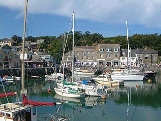
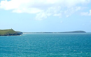
The ferry connects the town of Padstow on the west bank of the river to the village of Rock on the east bank. The route of the 630-mile (1,010 km) long South West Coast Path utilises the ferry. [3]
Padstow is a town, civil parish and fishing port on the north coast of Cornwall, England, United Kingdom. The town is situated on the west bank of the River Camel estuary, approximately 5 miles (8.0 km) northwest of Wadebridge, 10 miles (16 km) northwest of Bodmin and 10 miles (16 km) northeast of Newquay. The population of Padstow civil parish was 3,162 in the 2001 census, reducing to 2,993 at the 2011 census. In addition an electoral ward with the same name exists but extends as far as Trevose Head. The population for this ward is 4,434.


The River Camel is a river in Cornwall, England. It rises on the edge of Bodmin Moor and with its tributaries its catchment area covers much of North Cornwall. The river flows into the eastern Celtic Sea between Stepper Point and Pentire Point having covered about 30 miles, making it the second longest river wholly in Cornwall. The river is tidal upstream to Egloshayle and is popular for sailing, birdwatching and fishing. The name Camel comes from the Cornish language for 'the crooked one', a reference to its winding course. Historically the river was divided into three named stretches. Heyl was the name for the estuary up to Egloshayle, the River Allen was the stretch between Egloshayle and Trecarne, whilst the Camel was reserved for the stretch of river between its source and Trecarne.

Fowey is a port town and civil parish at the mouth of the River Fowey in south Cornwall, England, United Kingdom. The town has been in existence since well before the Norman invasion, with the local church first established some time in the 7th century; the estuary of the River Fowey forms a natural harbour which enabled the town to become an important trading centre. Privateers also made use of the sheltered harbourage. The Lostwithiel and Fowey Railway brought China clay here for export.

North Cornwall is an area of Cornwall, England, United Kingdom. It is also the name of a former local government district, which was administered from Bodmin and Wadebridge 50.516°N 4.835°W. Other towns in the area are Launceston, Bude, Padstow, and Camelford.

Saltash is a town and civil parish in south Cornwall, England, United Kingdom. It had a population of 16,184 in 2011 census. Saltash faces the city of Plymouth over the River Tamar and is popularly known as "the Gateway to Cornwall". Saltash’s landmarks include the Tamar Bridge which connects Plymouth to Cornwall by road, and the Royal Albert Bridge. The area of Latchbrook is part of the town.

The River Fal flows through Cornwall, England, United Kingdom, rising at Pentevale on Goss Moor and reaching the English Channel at Falmouth. On or near the banks of the Fal are the castles of Pendennis and St Mawes as well as Trelissick Garden. The River Fal separates the Roseland peninsula from the rest of Cornwall. Like most of its kind on the south coast of Cornwall and Devon, the Fal estuary is a classic ria, or drowned river valley. The Fal estuary from Tregony to the Truro River was originally called Hafaraell.

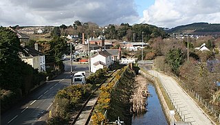
Wadebridge is a town and civil parish in north Cornwall, England, United Kingdom. The town straddles the River Camel five miles upstream from Padstow. The permanent population was 6,222 in the census of 2001, increasing to 7,900 in the 2011 census. There are two electoral wards in the town. Their total population is 8,272.

St Mawes is a village on the end of the Roseland Peninsula, in the eastern side of Falmouth harbour, on the south coast of Cornwall, England. The village, formerly two separate hamlets, lies on the east bank of the Carrick Roads, a large waterway created after the Ice Age from an ancient valley which flooded as the melt waters caused the sea level to rise. The immense natural harbour thus created is claimed to be the third largest in the world. St Mawes was once a busy fishing port, but the trade declined during the 20th century and the village now serves as a popular tourist location, with many properties functioning as holiday accommodation. The village is in the civil parish of St Just in Roseland and lies within the Cornwall Area of Outstanding Natural Beauty (AONB).

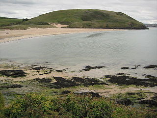
Rock is a coastal fishing village in Cornwall, England, United Kingdom. It is opposite Padstow on the north-east bank of the River Camel estuary. The village is in the civil parish of St Minver Lowlands about 4 miles (6.4 km) north-west of Wadebridge.

The Saints' Way is a long-distance footpath in mid Cornwall, England, UK.

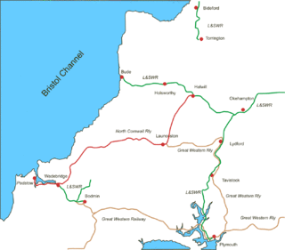
The North Cornwall Railway was a railway line running from Halwill in Devon to Padstow in Cornwall via Launceston, Camelford and Wadebridge, a distance of 49 miles 67 chains. Opened in the last decade of the nineteenth century, it was part of a drive by the London and South Western Railway (LSWR) to develop holiday traffic to Cornwall. The LSWR had opened a line connecting Exeter with Holsworthy in 1879, and by encouraging the North Cornwall Railway it planned to create railway access to previously inaccessible parts of the northern coastal area.
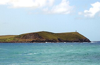
Stepper Point is a headland on the Atlantic coast in north Cornwall, England, United Kingdom. It is at grid reference SW911781. Stepper Point and Pentire Point stand at either side of the mouth of the River Camel; Stepper to the south-west, Pentire to the north-east.
The evolution of transport in Cornwall has been shaped by the county's strong maritime, mining and industrial traditions and much of the transport infrastructure reflects this heritage.
Trevose Head is a headland on the Atlantic coast of north Cornwall, on the south-western coast of Great Britain. It is situated approximately 5 miles (8.0 km) west of Padstow. The South West Coast Path runs around the whole promontory and is within the Cornwall Area of Outstanding Natural Beauty and the Trevose Head Heritage Coast. In clear weather, visitors to Trevose Head can see virtually the whole length of the north Cornwall coast; to the north, the view extends beyond the Cornwall county boundary to Hartland Point, Devon; to the south, it extends beyond St Ives to the headland at Pendeen Watch.

Lanteglos is a coastal civil parish in south Cornwall, England, United Kingdom. It is on the east side of the tidal estuary of the River Fowey which separates it from the town and civil parish of Fowey. The South West Coast Path runs along the southern coasts of the parish and much of the southern part of the parish lies in the Polruan to Polperro Site of Special Scientific Interest managed by the National Trust.

The Doom Bar is a sandbar at the mouth of the estuary of the River Camel, where it meets the Celtic Sea on the north coast of Cornwall, England. Like two other permanent sandbanks further up the estuary, the Doom Bar is composed mainly of marine sand that is continually being carried up from the seabed. More than 60 percent of the sand is derived from marine shells, making it an important source of agricultural lime, which has been collected for hundreds of years; an estimated 10 million tons of sand or more has been removed from the estuary since the early nineteenth century, mainly by dredging.

50°32′18″N4°56′16″W / 50.5384°N 4.9378°W
| Unitary authorities | |
|---|---|
| Major settlements (cities in italics) |
|
| Rivers | |
| Topics | |
| | This Cornwall article is a stub. You can help Wikipedia by expanding it. |
| | This ferry article is a stub. You can help Wikipedia by expanding it. |