Boger City, North Carolina

Last updated

Boger City, North Carolina
NCMap-doton-BogerCity.PNG
Location of Boger City, North Carolina
Coordinates: 35°28′50″N81°12′48″W / 35.48056°N 81.21333°W / 35.48056; -81.21333 [1]
Country United States
State North Carolina
County Lincoln
City Lincolnton
Annexed1986
Named for Robert Boger [2]
Area
  Total0.7 sq mi (1.8 km2)
  Land0.7 sq mi (1.8 km2)
  Water0.0 sq mi (0.0 km2)
Elevation
[1]
984 ft (300 m)
Population
 (2000)
  Total554
  Density784.5/sq mi (302.9/km2)
Time zone UTC-5 (Eastern (EST))
  Summer (DST) UTC-4 (EDT)
ZIP code
28092
Area code 704
FIPS code 37-06720 [3]
GNIS feature ID1023370 [1]

Boger City is a neighborhood of the city of Lincolnton in Lincoln County, North Carolina, United States. The population was 554 at the 2000 census, at which time it was erroneously listed as a census-designated place. [4]

Contents

Boger City was an independent town before 1986, when it was annexed by Lincolnton. [5]

Geography

According to the United States Census Bureau, the Boger City CDP had a total area of 0.7 square miles (1.8 km2), all land.

Demographics

As of the census [3] of 2000, there were 554 people, 227 households, and 152 families residing in the CDP. The population density was 784.5 inhabitants per square mile (302.9/km2). There were 234 housing units at an average density of 331.4 per square mile (128.0/km2). The racial makeup of the CDP was 91.34% White, 7.25% African American, 0.18% Native American, 0.18% Pacific Islander, 4.33% from other races, and 0.72% from two or more races. Hispanic or Latino of any race were 2.16% of the population.

There were 227 households, out of which 33.5% had children under the age of 18 living with them, 51.1% were married couples living together, 9.3% had a female householder with no husband present, and 32.6% were non-families. 27.8% of all households were made up of individuals, and 12.3% had someone living alone who was 65 years of age or older. The average household size was 2.44 and the average family size was 2.95.

In the CDP the population was spread out, with 24.4% under the age of 18, 9.2% from 18 to 24, 29.8% from 25 to 44, 23.5% from 45 to 64, and 13.2% who were 65 years of age or older. The median age was 38 years. For every 100 females, there were 102.2 males. For every 100 females age 18 and over, there were 92.2 males.

The median income for a household in the CDP was $34,286, and the median income for a family was $43,542. Males had a median income of $31,917 versus $16,989 for females. The per capita income for the CDP was $17,432. About 12.7% of families and 12.5% of the population were below the poverty line, including 17.5% of those under age 18 and 11.1% of those age 65 or over.

Related Research Articles

<span class="mw-page-title-main">Wabasso Beach, Florida</span> CDP in Florida, United States

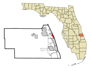
Wabasso Beach is a census-designated place (CDP) in Indian River County, Florida, United States. The population was 1,853 at the 2010 census, an increase of 72.4% since 2000. It is part of the Sebastian–Vero Beach Metropolitan Statistical Area.

<span class="mw-page-title-main">Lincolnton, Georgia</span> City in Georgia, United States

The city of Lincolnton is the county seat of Lincoln County, Georgia, United States. The population was 1,480 at the 2020 census. It contains numerous houses and historic districts listed on the National Register of Historic Places. Both the city and the county were named for General Benjamin Lincoln, who served in the Continental Army during the American Revolution.

<span class="mw-page-title-main">Scotts Corners, New York</span> CDP in New York, United States

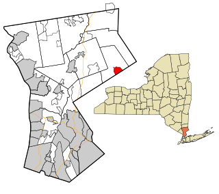
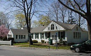
Scotts Corners is a hamlet located in the town of Pound Ridge in Westchester County, New York, United States. As of the 2010 census, the CDP population was 711, making Scotts Corners Westchester County's smallest census-recognized area.

<span class="mw-page-title-main">Altamahaw, North Carolina</span> Census-designated place in North Carolina, United States

Altamahaw is a census-designated place (CDP) in Alamance County, North Carolina, United States. It is part of the Burlington, North Carolina Metropolitan Statistical Area. As of the 2010 census it had a population of 347. The community was listed as Altamahaw-Ossipee at the 2000 census, at which time the population was 996. The town of Ossipee incorporated in 2002 and currently has a population of 543. The remainder of the territory was reassigned as the Altamahaw CDP.

<span class="mw-page-title-main">Royal Pines, North Carolina</span> Census-designated place in North Carolina, United States

Royal Pines is a census-designated place (CDP) in Buncombe County, North Carolina, United States. The population was 4,272 at the 2010 census. It is part of the Asheville Metropolitan Statistical Area.

<span class="mw-page-title-main">Salem, North Carolina</span> Census-designated place in North Carolina, United States

Salem is a census-designated place (CDP) in Burke County, North Carolina, United States. The population was 2,218 at the 2010 census. It is part of the Hickory–Lenoir–Morganton Metropolitan Statistical Area.

Lake Norman of Catawba is a census-designated place (CDP) in Catawba County, North Carolina, United States. The population was 11,395 at the 2020 census up from 7,411 at the 2010 census. It is part of the Hickory-Lenoir-Morganton Metropolitan Statistical Area.

<span class="mw-page-title-main">St. Stephens, North Carolina</span> Census-designated place in North Carolina, United States

St. Stephens is a census-designated place (CDP) in Catawba County, North Carolina, United States. The population was 8,759 at the 2010 census, down from 9,439 in 2000. It is part of the Hickory–Lenoir–Morganton Metropolitan Statistical Area.

<span class="mw-page-title-main">Valley Hill, North Carolina</span> Census-designated place in North Carolina, United States

Valley Hill is an unincorporated community and census-designated place (CDP) in Henderson County, North Carolina, United States. The population was 2,070 at the 2010 census. It is part of the Asheville Metropolitan Statistical Area.

<span class="mw-page-title-main">Lowesville, North Carolina</span> Census-designated place in North Carolina, United States

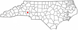
Lowesville is a census-designated place (CDP) in Lincoln County, North Carolina, United States. The population was 2,945 at the 2010 census, up from 1,440 in 2000.

Raemon is a census-designated place (CDP) in Robeson County, North Carolina, United States. The population was 212 at the 2000 census.

<span class="mw-page-title-main">Belvedere, South Carolina</span> Census-designated place in South Carolina, United States of America

Belvedere is a census-designated place (CDP) and suburb of North Augusta in Aiken County, South Carolina, United States. It is part of the Augusta, Georgia metropolitan area. The population was 5,792 at the 2010 census.

<span class="mw-page-title-main">City View, South Carolina</span> Census-designated place in South Carolina, United States

City View, a former incorporated city, is now a census-designated place (CDP) in Greenville County, South Carolina, United States. The population was 1,345 at the 2010 census, up from 1,254 in 2000. It is part of the Greenville–Mauldin–Easley Metropolitan Statistical Area.

Wade Hampton is a census-designated place (CDP) in Greenville County, South Carolina, United States. The population was 20,622 at the 2010 census. It is named for American Civil War general and South Carolina governor Wade Hampton.

<span class="mw-page-title-main">Red Hill, South Carolina</span> Census-designated place in South Carolina, United States

Red Hill is a census-designated place (CDP) in Horry County, South Carolina, United States. The population was 13,223 at the 2010 census, up from 10,509 at the 2000 census.

<span class="mw-page-title-main">Irwin, South Carolina</span> Census-designated place in South Carolina, United States

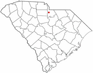
Irwin is an unincorporated community and census-designated place (CDP) in Lancaster County, South Carolina, United States. The population was 1,405 at the 2010 census.

Seven Oaks is a census-designated place (CDP) in Lexington County, South Carolina, United States, 8 miles (13 km) northwest of downtown Columbia, the state capital. The population of the CDP was 15,144 at the 2010 census. It is part of the Columbia Metropolitan Statistical Area.

<span class="mw-page-title-main">Inman Mills, South Carolina</span> CDP in South Carolina, United States

Inman Mills is a census-designated place (CDP) in Spartanburg County, South Carolina, United States. The population was 1,050 at the 2010 census.

<span class="mw-page-title-main">India Hook, South Carolina</span> CDP in South Carolina, United States

India Hook is a census-designated place (CDP) in York County, South Carolina, United States. The majority of India Hook is annexed into the city of Rock Hill, but as of 2010 India Hook is still considered to be a CDP. It is one of the three communities located on Lake Wylie.

<span class="mw-page-title-main">Brookhaven (CDP), New York</span> Hamlet and census-designated place in New York, United States

Brookhaven is a hamlet and census-designated place in Suffolk County, New York, United States. The population was 3,451 at the 2010 census.

References

  1. 1 2 3 U.S. Geological Survey Geographic Names Information System: Boger City, North Carolina
  2. "North Carolina Gazetteer" . Retrieved August 13, 2023.
  3. 1 2 "U.S. Census website". United States Census Bureau . Retrieved January 31, 2008.
  4. U.S. Census Bureau Geographic Change Notes
  5. Harrison, Jenna-Ley. "New City Fire Station Opened in Boger City". Lincoln Times-News. Archived from the original on April 9, 2016. Retrieved March 26, 2016.