Westport, North Carolina

Last updated

Westport, North Carolina
NCMap-doton-Westport.PNG
Location of Westport, North Carolina
Coordinates: 35°30′37″N80°58′42″W / 35.51028°N 80.97833°W / 35.51028; -80.97833
Country United States
State North Carolina
County Lincoln
Area
[1]
  Total5.61 sq mi (14.52 km2)
  Land3.67 sq mi (9.51 km2)
  Water1.94 sq mi (5.02 km2)
Elevation
[2]
758 ft (231 m)
Population
 (2020)
  Total5,705
  Density1,554.07/sq mi (600.05/km2)
Time zone UTC-5 (Eastern (EST))
  Summer (DST) UTC-4 (EDT)
FIPS code 37-72755 [3]
GNIS feature ID2403015 [2]

Westport is an unincorporated community and census-designated place (CDP) located in Lincoln County, North Carolina, United States. The population of the CDP was 4,026 at the 2010 census, [4] up from 2,006 at the 2000 census. The community's name comes from its location on the west side of Lake Norman.

Contents

Geography

Westport is located in the northeast corner of Lincoln County along several coves on the western shore of Lake Norman, a reservoir on the Catawba River. The southern border of the CDP is Graham Creek, while Burton Creek reaches into the center of the community. The eastern border of the CDP is the Lincoln County line in the center of Lake Norman, with Iredell County to the east.

North Carolina Highway 16 Business forms the western edge of the Westport CDP. The highway leads northwest 3.5 miles (5.6 km) to Denver and south 5 miles (8 km) to Lowesville. Downtown Charlotte is 24 miles (39 km) to the southeast of Westport.

According to the United States Census Bureau, the CDP has a total area of 5.6 square miles (14.5 km2), of which 3.7 square miles (9.5 km2) are land and 1.9 square miles (5.0 km2), or 34.54%, are water. [5]

Demographics

Historical population
CensusPop.Note
2020 5,705
U.S. Decennial Census [6]

2020 census

Westport racial composition [7]
RaceNumberPercentage
White (non-Hispanic)5,10989.55%
Black or African American (non-Hispanic)1562.73%
Native American 20.04%
Asian 621.09%
Other/Mixed 1823.19%
Hispanic or Latino 1943.4%

As of the 2020 United States census, there were 5,705 people, 1,586 households, and 1,321 families residing in the CDP.

2000 census

As of the census [3] of 2000, there were 2,006 people, 776 households, and 650 families residing in the CDP. The population density was 653.3 people per square mile (252.2 people/km2). There were 826 housing units at an average density of 269.0 per square mile (103.9/km2). The racial makeup of the CDP was 98.01% White, 0.75% African American, 0.05% Native American, 0.75% Asian, 0.05% from other races, and 0.40% from two or more races. Hispanic or Latino of any race were 0.95% of the population.

There were 776 households, out of which 32.2% had children under the age of 18 living with them, 77.3% were married couples living together, 4.5% had a female householder with no husband present, and 16.2% were non-families. 12.6% of all households were made up of individuals, and 4.0% had someone living alone who was 65 years of age or older. The average household size was 2.58 and the average family size was 2.82.

In the CDP, the population was spread out, with 23.2% under the age of 18, 3.3% from 18 to 24, 27.8% from 25 to 44, 34.0% from 45 to 64, and 11.6% who were 65 years of age or older. The median age was 42 years. For every 100 females, there were 101.4 males. For every 100 females age 18 and over, there were 98.1 males.

The median income for a household in the CDP was $81,232, and the median income for a family was $82,422. Males had a median income of $51,571 versus $31,016 for females. The per capita income for the CDP was $34,189. About 2.7% of families and 5.3% of the population were below the poverty line, including 7.7% of those under age 18 and 10.4% of those age 65 or over.

Related Research Articles

<span class="mw-page-title-main">Cypress Lake, Florida</span> Census-designated place in Florida, United States

Cypress Lake is an unincorporated community and census-designated place (CDP) in Lee County, Florida, United States. The population was 13,727 at the 2020 census. It is part of the Cape Coral-Fort Myers, Florida Metropolitan Statistical Area.

<span class="mw-page-title-main">Hawaiian Acres, Hawaii</span> Census-designated place in Hawaii, United States

Hawaiian Acres is a census-designated place (CDP) in Hawaiʻi County, Hawaiʻi, United States located in the District of Puna. The population was 2,700 at the 2010 census, up from 1,776 at the 2000 census.

<span class="mw-page-title-main">Helena Valley Northeast, Montana</span> Census-designated place in Montana, United States

Helena Valley Northeast is a census-designated place (CDP) in Lewis and Clark County, Montana, United States. The population was 2,995 at the 2010 census. It is part of the Helena Micropolitan Statistical Area.

<span class="mw-page-title-main">Woodlawn, North Carolina</span> Census-designated place in North Carolina, United States

Woodlawn is a census-designated place in Alamance County, North Carolina, United States.

<span class="mw-page-title-main">Bethlehem, Alexander County, North Carolina</span> Census-designated place in North Carolina, United States

Bethlehem is a census-designated place (CDP) in Alexander County, North Carolina, United States. The population was 4,214 at the 2010 census. It is part of the Hickory–Lenoir–Morganton Metropolitan Statistical Area.

<span class="mw-page-title-main">Avery Creek, North Carolina</span> Census-designated place in North Carolina, United States

Avery Creek is a census-designated place (CDP) in Buncombe County, North Carolina, United States. The population was 1,950 at the 2010 census. It is part of the Asheville Metropolitan Statistical Area.

Lake Norman of Catawba is a census-designated place (CDP) in Catawba County, North Carolina, United States. The population was 11,395 at the 2020 census up from 7,411 at the 2010 census. It is part of the Hickory-Lenoir-Morganton Metropolitan Statistical Area.

<span class="mw-page-title-main">Mountain View, North Carolina</span> Census-designated place in North Carolina, United States

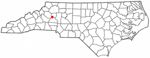
Mountain View is a census-designated place (CDP) in Catawba County, North Carolina, United States. The population was 3,552 at the 2010 census. It is part of the Hickory–Lenoir–Morganton Metropolitan Statistical Area.

<span class="mw-page-title-main">St. Stephens, North Carolina</span> Census-designated place in North Carolina, United States

St. Stephens is a census-designated place (CDP) in Catawba County, North Carolina, United States. The population was 8,759 at the 2010 census, down from 9,439 in 2000. It is part of the Hickory–Lenoir–Morganton Metropolitan Statistical Area.

<span class="mw-page-title-main">Buies Creek, North Carolina</span> Census-designated place in North Carolina, United States

Buies Creek is a census-designated place (CDP) located in the Neills Creek Township of Harnett County, North Carolina, United States. It is the home of Campbell University. The population was 3,253 at the 2020 census, up from 2,942 in 2010. Buies Creek is a part of the Dunn Micropolitan Area, which is also a part of the greater Raleigh–Durham–Cary Combined Statistical Area (CSA) as defined by the United States Census Bureau.

<span class="mw-page-title-main">Boger City, North Carolina</span> Place in North Carolina, United States

Boger City is a former town and present-day area in the city of Lincolnton in Lincoln County, North Carolina, United States. The population was 554 at the 2000 census, at which time it was erroneously listed as a census-designated place.

<span class="mw-page-title-main">Lowesville, North Carolina</span> Census-designated place in North Carolina, United States

Lowesville is a census-designated place (CDP) in Lincoln County, North Carolina, United States. The population was 2,945 at the 2010 census, up from 1,440 in 2000.

<span class="mw-page-title-main">Seven Lakes, North Carolina</span> CDP in North Carolina, United States

Seven Lakes is a census-designated place (CDP) in Moore County, North Carolina, United States. It is located approximately 10–15 minutes from the Pinehurst #2, where three U.S. Opens have been held, in 1999, 2005, and 2014. In 2018, the population of the Seven Lakes CDP was 4,404.

<span class="mw-page-title-main">Lincoln Beach, Oregon</span> Unincorporated community in the state of Oregon, United States

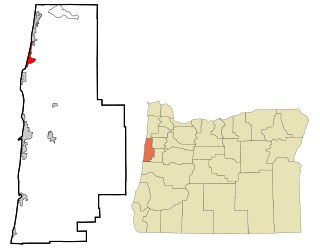
Lincoln Beach is a census-designated place (CDP) in Lincoln County, Oregon, United States. It includes the unincorporated communities of Lincoln Beach and Gleneden Beach. The total population was 2,045 at the 2010 census.

<span class="mw-page-title-main">Gantt, South Carolina</span> Census-designated place in South Carolina, United States

Gantt is a census-designated place (CDP) in Greenville County, South Carolina, United States. The population was 14,229 at the 2010 census. It is part of the Greenville–Mauldin–Easley Metropolitan Statistical Area and a suburb of the city of Greenville.

Parker is a census-designated place (CDP) in Greenville County, South Carolina, United States. The population was 11,431 at the 2010 census, up from 10,760 in 2000. It is part of the Greenville–Mauldin–Easley Metropolitan Statistical Area.

Wade Hampton is a census-designated place (CDP) in Greenville County, South Carolina, United States. The population was 20,622 at the 2010 census. It is named for American Civil War general and South Carolina governor Wade Hampton.

<span class="mw-page-title-main">Red Hill, South Carolina</span> Census-designated place in South Carolina, United States

Red Hill is a census-designated place (CDP) in Horry County, South Carolina, United States. The population was 13,223 at the 2010 census, up from 10,509 at the 2000 census.

<span class="mw-page-title-main">Inman Mills, South Carolina</span> CDP in South Carolina, United States

Inman Mills is a census-designated place (CDP) in Spartanburg County, South Carolina, United States. The population was 1,050 at the 2010 census.

<span class="mw-page-title-main">Ladson, South Carolina</span> Census-designated place in South Carolina, United States

Ladson is a census-designated place (CDP) in Berkeley, Charleston and Dorchester counties in the U.S. state of South Carolina. The population was 13,790 at the 2010 census. It is named in honor of the Ladson family, one of the oldest planter and merchant families in the Charleston area; one of its members was lieutenant governor James Ladson.

References

  1. "ArcGIS REST Services Directory". United States Census Bureau. Retrieved September 20, 2022.
  2. 1 2 U.S. Geological Survey Geographic Names Information System: Westport, North Carolina
  3. 1 2 "U.S. Census website". United States Census Bureau . Retrieved January 31, 2008.
  4. "Total Population: 2010 Census DEC Summary File 1 (P1), Westport CDP, North Carolina". data.census.gov. U.S. Census Bureau. Retrieved June 30, 2020.
  5. "U.S. Gazetteer Files: 2019: Places: North Carolina". U.S. Census Bureau Geography Division. Retrieved June 30, 2020.
  6. "Census of Population and Housing". Census.gov. Retrieved June 4, 2016.
  7. "Explore Census Data". data.census.gov. Retrieved December 21, 2021.