Bold Street, Liverpool

Last updated

Bold Street, Liverpool
Walking down Bold Street (51931351706).jpg
The top of Bold Street, March 2022
Liverpool Centre map.png
Red pog.svg
Location RopeWalks, Liverpool city centre
Postal codeL1
Coordinates 53°24′10″N2°58′40″W / 53.40278°N 2.97778°W / 53.40278; -2.97778
Other
Known for
  • Cafes, restaurants, independent shopping

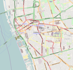
Bold Street is a street in Liverpool, England. It is known for its concentration of independent businesses and for the Church of St Luke (locally known as the "bombed-out church"), which is situated at the top end. The bottom end leads into the area surrounding Clayton Square, which is part of the main retail district of central Liverpool. The bottom end contains more shops which are chain stores. Liverpool Central, a major hub of the Merseyrail rapid transit/commuter rail network, can also be accessed via an entrance on Bold Street next to The Lyceum, a post office which was Europe's first lending library. The middle area contains bars as it leads towards Concert Square, a square containing clubs and bars, and the top end contains more independent shops and cafes. For the most part, Bold Street is pedestrianised and cars do not have access.

Contents

History

Bold Street was originally laid out as a ropewalk; a long thin area of land used in the manufacture of rope (the area is now known as 'Rope Walks'). They used to measure the rope from the top of Bold Street to the bottom because it was the standard length needed for sailing ships. [1] It was laid out for residences around 1780 and named after Jonas Bold, a noted sugar trader and banker. In 1802 Bold became Mayor of Liverpool. [2]

Merchants that worked on the docks needed houses close by. Therefore, houses were constructed in Hanover Street first, followed by Duke Street and then Bold Street. The fields that were in the area earlier were also developed quickly into houses. Although there had been port-related industrial activity in the area, with roperies occupying the site of what is now Bold Street to supply the sailing ships, this intensified along with a demand for residential properties so that the merchants could be located close to their business interests. [3]

Physician Jonathan Binns, an 18th-century abolitionist, was among those building a home on the street. [4] [5]

Bold Street, Ropewalks.jpg
Pavement cafe at bottom of Bold Street
Bold Street Pavement Art.JPG
Pavement art on Bold Street
Walking down Bold Street (51931351851).jpg
Walking down Bold Street
Walking down Bold Street (51931351706).jpg
Walking down Bold Street

Notable buildings and places of interest

The street is featured in a song of the same name by Liverpool-based singer-songwriter Eugene McGuinness, included on his debut EP, The Early Learnings of Eugene McGuinness, distributed by Domino Records in 2007. The song peaked at Number 37 in the Official Independent Singles Chart. [6]

See also

Related Research Articles

<span class="mw-page-title-main">Shanklin</span> Human settlement in England

Shanklin is a seaside resort town and civil parish on the Isle of Wight, England, located on Sandown Bay. Shanklin is the southernmost of three settlements which occupy the bay, and is close to Lake Sandown. The sandy beach, its Old Village and a wooded ravine, Shanklin Chine, are its main attractions. The esplanade along the beach is occupied by hotels and restaurants for the most part, and is one of the most tourist-oriented parts of the town. The other is the Old Village, at the top of Shanklin Chine. Together with Lake and Sandown to the north, Shanklin forms a built up area of around 25,000 inhabitants, Shanklin alone contributing around 7,200 of this.

This glossary of nautical terms is an alphabetical listing of terms and expressions connected with ships, shipping, seamanship and navigation on water. Some remain current, while many date from the 17th to 19th centuries. The word nautical derives from the Latin nauticus, from Greek nautikos, from nautēs: "sailor", from naus: "ship".

<span class="mw-page-title-main">Church of St Luke, Liverpool</span> Former church in Liverpool city centre, England that was partially destroyed by bombing in WW2

St Luke's Church, more commonly known by locals as the bombed-out church, is a former Anglican parish church in Liverpool, England. It stands on the corner of Berry Street and Leece Street, at the top of Bold Street.

<span class="mw-page-title-main">Liverpool One</span> Shopping, residential and leisure complex in Liverpool, England

Liverpool ONE is a shopping, residential, and leisure complex in Liverpool, England. The project involved the redevelopment of 42 acres of land in the city centre. It is a retail-led development anchored by the department store John Lewis. Debenhams had previously been an anchor tenant until the closure of its Liverpool One store in March 2021, with Marks & Spencer taking its place in mid-2023. Additional elements include leisure facilities, apartments, offices, public open spaces, restaurants, and transport improvements. The completion of Liverpool ONE significantly boosted the local economy, while lifting Liverpool into the top five most popular retail destinations in the UK.

<span class="mw-page-title-main">The Lyceum, Liverpool</span> Neoclassical Grade II* listed building in Liverpool, England

The Lyceum is a Neoclassical Grade II* listed building located on Bold Street, Liverpool. It was constructed in 1802 as a news-room and England's first subscription library (1758–1942) and later became a gentleman's club. After the club relocated in 1952 the building was left unoccupied for many years, eventually falling into a state of disrepair. Calls were made for its demolition in the late 1970s, sparking a campaign to save the building. It reopened as a post office, and then a branch of the Co-operative Bank. As of May 2024, its tenants are a Chinese restaurant and a miniature golf and bar venue called One Below.

<span class="mw-page-title-main">Wellington's Column</span> Monument to the Duke of Wellington in Liverpool

Wellington's Column, or the Waterloo Memorial, is a monument to the Duke of Wellington standing on the corner of William Brown Street and Lime Street, Liverpool, Merseyside, England. It is recorded in the National Heritage List for England as a designated Grade II* listed building.

<span class="mw-page-title-main">Sheffield City Centre</span> Central business district in South Yorkshire, England

Sheffield City Centre is a district of the City of Sheffield and is covered partly by the City ward of the City of Sheffield. It includes the area that is within a radius of roughly 0.75 miles (1.2 km) of Sheffield Cathedral and is encircled by the Inner Ring Road, a circular route started in the late 1960s and completed in 2007. As well as the cathedral, buildings in the city centre include the Grade I listed Town Hall, the City Hall and the Winter Gardens. Several areas of the city centre have been designated as quarters. It is home to the city's major business, transport, leisure and cultural attractions.

<span class="mw-page-title-main">Gardiner Street</span> Street in Dublin, Ireland

Gardiner Street is a long Georgian street in Dublin, Ireland. It stretches from the River Liffey at its southern end via Mountjoy Square to Dorset Street at its northern end. The Custom House terminates the vista at the southern end, and the street is divided into Gardiner Street Upper, Gardiner Street Middle and Gardiner Street Lower.

<span class="mw-page-title-main">Merchants Square</span> 20th-century interpretation of an 18th-century-style retail village in Colonial Williamsburg, VA, US

Merchants Square is a 20th-century interpretation of an 18th-century-style retail village in Colonial Williamsburg, Virginia, United States. It is listed on the National Register of Historic Places.

<span class="mw-page-title-main">Architecture of Liverpool</span> Overview of architecture of Liverpool, England

The architecture of Liverpool is rooted in the city's development into a major port of the British Empire. It encompasses a variety of architectural styles of the past 300 years, while next to nothing remains of its medieval structures which would have dated back as far as the 13th century. Erected 1716–18, Bluecoat Chambers is supposed to be the oldest surviving building in central Liverpool.

<span class="mw-page-title-main">Marylebone</span> Area in London, England

Marylebone is an area in London, England and is located in the City of Westminster. It is in Central London and part of the West End. Oxford Street forms its southern boundary.

<span class="mw-page-title-main">Concert Square, Liverpool</span> Square in Liverpool City Centre, England

Concert Square is a square located between Wood Street and Fleet Street in the RopeWalks area of Liverpool City Centre, England. The square and the immediate surrounding area is often referred to as the heart of Liverpool's nightlife, due to the area being populated with some of the best known nightclubs and bars in the city, and indeed the North West of England. The square has often been a centre for football fans' celebration. A 2019 survey of university students in the UK found two Liverpool universities ranked amongst the top 5 for nightlife, with Concert Square being cited as a factor.

<span class="mw-page-title-main">Clayton Square Shopping Centre</span> Shopping mall in Merseyside, England

Clayton Square Shopping Centre is an inner-city shopping centre located in Liverpool, England. It is in close proximity to Liverpool Lime Street and Liverpool Central railway stations. It is the city's fourth largest shopping centre behind Liverpool One, St. John's Shopping Centre and Metquarter. Clayton Square sees tough competition from the likes of Liverpool One, St.Johns, Metquarter, Church Street, Lord Street and Bold Street.

Glasgow City Centre is the central business district of Glasgow, Scotland. Is bounded by Saltmarket, High Street and Castle Street to the east, The River Clyde to the south and the M8 motorway to its west and north. Glasgow City Centre is composed of the areas of Garnethill, Blythswood Hill and Merchant City as well as parts of Cowcaddens, Townhead, Anderston and Calton.

<span class="mw-page-title-main">Liverpool city centre</span> Commercial, cultural, financial and historical heart of Liverpool, England

Liverpool city centre is the commercial, cultural, financial and historical centre of Liverpool and the Liverpool City Region, England. Different definitions of the city centre exist for urban planning and local government, however, the border of Liverpool city centre is broadly marked by the inner city districts of Vauxhall, Everton, Edge Hill, Kensington and Toxteth.

<span class="mw-page-title-main">RopeWalks, Liverpool</span> Shopping, leisure and nightlife district of Liverpool UK

RopeWalks is a district of Liverpool city centre bounded by Hanover Street to the north-west, Lydia Ann Street to the west, Roscoe Street to the east and Back Bold Street to north-east.

Retail & Leisure BID is a business improvement district (BID) that represents over 650 businesses in the retail and leisure heart of Liverpool's city centre, covering a total area of 49 acres and including 61 streets, such as Bold Street, Church Street, Lord Street, the Cavern Quarter, Whitechapel, Williamson Square, Queen Square, Ranelagh Street and all inter-connecting streets. The BID aims to enhance the public services of the local authority by raising a 1.2% levy on its members' annual business rates. This five-year program is intended to provide a safe, clean, attractive, and well-promoted trading area within Liverpool's city centre.

<span class="mw-page-title-main">Middlesbrough Town Hall</span> Building in North Yorkshire, England

Middlesbrough Town Hall is a municipal facility located in Albert Road in Middlesbrough, North Yorkshire, England. It is a Grade II* listed building.

<span class="mw-page-title-main">Jackstay</span> Substantial line between two points used to guide or support.

A jackstay is a cable or bar between two points to support and guide a load between those points, or as an anchor to attach something to be constrained along that line. The term is mostly used in a marine context and originated on sailing ships. Note the use of "stay" implies load bearing working rigging. In diving it is also a line to guide the movements of a diver between the endpoints.

This glossary of nautical terms is an alphabetical listing of terms and expressions connected with ships, shipping, seamanship and navigation on water. Some remain current, while many date from the 17th to 19th centuries. The word nautical derives from the Latin nauticus, from Greek nautikos, from nautēs: "sailor", from naus: "ship".

References

  1. "Bold Street Special". Liverpool Echo. Retrieved 26 September 2010.
  2. "Liverpool Slavery History Trail, Accessible Version". Liverpool museums. Archived from the original on 5 December 2010. Retrieved 25 September 2010.
  3. "Duke Street Area, Accessible Version". Liverpool World Heritage City. Archived from the original on 26 June 2009. Retrieved 26 September 2010.
  4. Saxton, Eveline B (1959). Transactions of the Historic Society of Lancashire And Cheshire (PDF). p. 179.
  5. "First Petition to Parliament". The Abolition Project. Retrieved 1 September 2019.
  6. "Bold Street by Eugene McGuiness". Official Charts Company. Retrieved 28 April 2024.