Boucher Trail

Last updated
Boucher Trail
Grca-boucher-tr.jpg
Travertine Canyon and Whites Butte
Length9 mi (14 km)
Location Grand Canyon National Park, Arizona, United States
Trailheads Dripping Springs Trail
Colorado River
Use Hiking
Elevation
Elevation change 2,900 ft (880 m)
Highest pointYuma Point, 5,240 ft (1,600 m)
Lowest point Colorado River, 2,340 ft (710 m)
Hiking details
Trail difficultyVery Strenuous
SeasonSpring through Fall
Sights Grand Canyon
Colorado River
Hazards Severe Weather
Overexertion
Dehydration
Flash Flood

The Boucher Trail is a hiking trail of the South Rim in Grand Canyon National Park, located in the U.S. state of Arizona.

Contents

Access and description

The trail officially begins at a low point on the Dripping Springs Trail, in the southwest part of Hermit Canyon. Access to the Boucher Trail requires a hike of about 2 34 miles (4.4 km) along the Hermit Trail and Dripping Springs Trail. Cairns exist in key places and can be spotted with some careful looking.

The trail heads to the north and has little elevation change after leaving the Hermit Trail. There are a few short, sharp descents and climbs around minor rockfalls and washbeds. After about 3 miles (4.8 km) the trail contours around Yuma Point and heads southwestward until a sharp descent at the head of Travertine Canyon through the Supai Group. This descent steepens above 25% at places, which requires care to descend. Hikers descending in this area may need to exercise care as some points require steps down of three to five feet (0.91 to 1.52 m). After the descent, the trail heads up for a short stretch on the east side of Travertine Canyon, then immediately crosses over to a long stretch on the west side of Travertine Canyon to the Whites Butte saddle between Travertine and Boucher Canyons.

Boucher Creek Grca-bouchercreek.jpg
Boucher Creek

After the Whites Butte saddle, the trail descends through a natural break in the Redwall Limestone onto the Tonto Platform to a junction with the Tonto Trail. This section is not as steep as the Travertine Canyon section, but can still exceed a 20% grade. The junction is marked by a noticeable cairn. At the junction, the Tonto Trail heads east towards Hermit Canyon or west into the Boucher Creek drainage.

To the west, the Boucher Trail and Tonto Trail descend through the Tapeats Sandstone for 34 mi (1.2 km) to Boucher Creek. At the confluence of Boucher Creek and Topaz Creek, the Tonto Trail splits off and continues northwest, while the Boucher Trail follows the creek northeast as it continues to flow to the Colorado River, which marks the end of the trail. Boucher Creek's flow disappears and reappears numerous times on this section of the trail.

Mileages and features along the Boucher Trail [1] Add mileage hiked on other trails.
Distance (mi)Elv (ft)LocationConnecting trailsToiletWater
05140Trailhead Dripping Springs Trail
25240Yuma Point
4.54900Whites Butte Saddle
63100Trail Junction Tonto Trail east
6.72770Boucher CreekBoucher Creek, Perennial
6.92700Trail Junction Tonto Trail westBoucher Creek, Perennial
8.12320Boucher Rapids, Colorado River Boucher Creek, Colorado River

Condition

Grand Canyon National Park categorizes the Boucher Trail as a "primitive trail". With this designation it receives only low-key maintenance as conditions warrant, or to prevent resource damage. There are few patrols by park rangers along primitive trails, depending on daily usage. [2]

The Boucher Trail is less travelled than the Hermit Trail on the other side of Hermit Canyon and is not as well defined. Because of this, the trail can be hard to pick out in places and is overgrown in a few places by canyon flora. The section descending the Supai Group in Travertine Canyon is marked by rockfalls and is exceedingly steep, requiring care when descending.

Water availability

The only water sources along the trail are in the last mile at Boucher Creek and at the Colorado River. An additional water source can be found at Dripping Springs, on the Dripping Springs Trail about a mile northwest of its junction with the Boucher Trail. All natural water sources need to be treated, filtered, or boiled prior to consumption.

Camping

Camping is allowed at-large along the Boucher Trail, except within ¼ mile of the junction with the Dripping Springs Trail. The park requires selecting campsites that have been previously used. Due to the proximity to water, there are many suitable camping locations around Boucher Creek.

Use areas along Tonto Trail from east to west
AreaNameTypeGroup(s)PartiesMax People
BN9BoucherAt-large1and223

Hazards

Hazards hikers can encounter along the 'Boucher Trail include dehydration, sudden rainstorms, flash flooding, loose footing, rockfall, encounters with wildlife, and extreme heat. At the Colorado River, additional hazards include hypothermia (due to the river's consistently cold temperatures), trauma (due to collisions with boulders in rapids), and drowning. [ citation needed ]

Hikers are more likely to find solitude and isolation in addition to other hazards related to desert hiking. [3]

History

The trail is named for Grand Canyon prospector and guide Louis Boucher, who lived in a cabin he built alongside Boucher Creek while mining in the area. He lived alone while in the canyon, making supply runs to the south rim from time to time. Because of his solitude, he was often labeled as a hermit, and is often credited as being the hermit referenced by canyon features of the same name, including the Hermit Trail.

See also

Related Research Articles

South Kaibab Trail Grand Canyon hiking trail

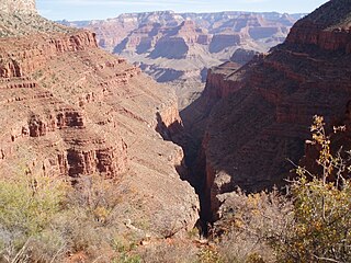
The South Kaibab Trail is a hiking trail in Grand Canyon National Park, located in the U.S. state of Arizona. Unlike the Bright Angel Trail which also begins at the south rim of the Grand Canyon and leads to the Colorado River, the South Kaibab Trail follows a ridge out to Skeleton Point allowing for 360-degree views of the canyon.

Bright Angel Trail Grand Canyon hiking trail

The Bright Angel Trail is a hiking trail located in Grand Canyon National Park in the U.S. state of Arizona.

North Kaibab Trail Grand Canyon hiking trail

The North Kaibab Trail is a hiking trail in the North Rim side of the Grand Canyon, in Grand Canyon National Park, located in the U.S. state of Arizona.

Hermit Trail Grand Canyon hiking trail

The Hermit Trail is a hiking trail in Grand Canyon National Park, located in the U.S. state of Arizona. This trail provides access to a historic area of Grand Canyon and offers a more challenging route to the Colorado River for more experienced canyon hikers.

Tonto Trail Grand Canyon hiking trail

The Tonto Trail is a hiking trail on the South Rim of the Grand Canyon in Grand Canyon National Park, located in the U.S. state of Arizona.

River Trail (Arizona) Grand Canyon hiking trail

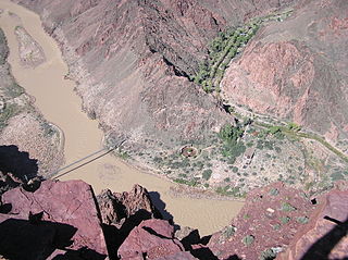
The River Trail is a hiking trail in Grand Canyon National Park, located in the U.S. state of Arizona. This trail connects the end of the Bright Angel Trail with Phantom Ranch and the South Kaibab Trail.

Clear Creek Trail Grand Canyon hiking trail

The Clear Creek Trail is a hiking trail below the North Rim, from lower Bright Angel Canyon into lower Clear Creek Canyon of the Grand Canyon National Park, located in the U.S. state of Arizona.

Plateau Point Trail Grand Canyon hiking trail

The Plateau Point Trail is a hiking and pack trail located on the South Rim of the Grand Canyon National Park, located in the U.S. state of Arizona.

Grandview Trail Grand Canyon hiking trail

The Grandview Trail is a hiking trail located on the South Rim of the Grand Canyon National Park, located in the U.S. state of Arizona.It was built in 1893 by miners and is noted for its cobblestone and cribbing sections.

Dripping Springs Trail Grand Canyon hiking trail

The Dripping Springs Trail is a hiking trail on the South Rim of the Grand Canyon National Park, located in the U.S. state of Arizona.

Tanner Trail Grand Canyon hiking trail

The Tanner Trail is a hiking trail located on the South Rim of the Grand Canyon National Park, located in the U.S. state of Arizona. The trailhead is located at Lipan Point, a prominent lookout located to the east of the Grand Canyon Village, and the trail ends at the Colorado River at Tanner Rapids.

South Bass Trail Grand Canyon hiking trail

The South Bass Trail is a hiking trail located on the South Rim of the Grand Canyon National Park, located in the U.S. state of Arizona.

Havasu Creek

Havasu Creek is a stream in the U.S. state of Arizona associated with the Havasupai people. It is a tributary to the Colorado River, which it enters in the Grand Canyon.

Newton Butte

Newton Butte, in the Grand Canyon, Arizona, United States is a prominence below the South Rim, northwest of Grandview Point, and north on a ridgeline from Shoshone Point which is one mile east of Yaki Point, East Rim Drive. Shoshone Point and Yaki are both on access roads from East Rim Drive, with Yaki being the more advantageous to different viewing directions.

Isis Temple

Isis Temple, in the Grand Canyon, Arizona, USA, is a prominence below the North Rim, and adjacent to Granite Gorge. The prominence lies north of the north bank of the west-flowing Colorado River and is just north of Granite Gorge. The Trinity Creek and canyon flow due-south at its west border; its north, and northeast border/flank is formed by Phantom Creek and canyon, a west tributary of Bright Angel Creek; the creeks intersect about 3 mi southeast, and 1 mi north of Granite Gorge. The Isis Temple prominence, is only ~202 ft lower than Grand Canyon Village, the main public center on Grand Canyon’s South Rim.

Angels Gate

Angels Gate is a 6,761-foot (2,061 m)-elevation summit located in the Grand Canyon, in Coconino County of Arizona, United States. It is situated seven miles (11 km) due north of the Grandview Point overlook on the canyon's South Rim, three miles (4.8 km) west of Vishnu Temple, and three point five miles (5.6 km) southeast of Zoroaster Temple. Topographic relief is significant as it rises over 4,200 feet (1,300 m) above the Colorado River in three miles. Angels Gate is the place in Paiute mythology where the gods would return to earth by descending from the shadow world above. George Wharton James applied the "Angel Gate" name to this geographical feature in his book, In & Around the Grand Canyon, in 1900. This feature's name was officially adopted in 1906 by the U.S. Board on Geographic Names. Angels Gate has four peaks composed of Coconino Sandstone. The main highest summit and three spires are known as "Snoopy and his Doghouse" for a resemblance to Snoopy, and the first ascent was made April 1972 by Chuck Graf and Dave Ganci. According to the Köppen climate classification system, Angels Gate is located in a cold semi-arid climate zone.

Whites Butte

Whites Butte is a 4,860-foot (1,480 m) prominence adjacent the course of the Colorado River near the beginning of the Western Grand Canyon,. The butte lies at the terminus of Travertine Canyon, the adjacent canyon west of Hermit Canyon. The Boucher Trail which begins at Upper Hermit Canyon, courses the east base of Whites Butte to reach the Tonto Trail-(west), on the Tonto Platform, south side of the Colorado River.

ONeill Butte

O'Neill Butte is a 6,071-foot (1,850 m)-elevation summit located in the Grand Canyon, in Coconino County of northern Arizona, United States. It is situated 2.5 miles (4.0 km) east-northeast of Grand Canyon Village, one mile (1.6 km) northeast of Mather Point, and one mile immediately northwest of Yaki Point. Cedar Ridge connects O'Neill Butte with Yaki Point on the South Rim. Topographic relief is significant as O'Neill Butte rises 3,600 feet (1,100 m) above the Colorado River in two miles (3.2 km). Access to this prominence is via the South Kaibab Trail which traverses the east slope of the peak. According to the Köppen climate classification system, O'Neill Butte is located in a cold semi-arid climate zone.

Topaz Canyon

Topaz Canyon is a linear, narrow canyon in western Grand Canyon, below the South Rim. It lies in a region of four canyons, and a fifth smaller canyon, all trending mostly northeasterly towards the west-flowing Colorado River, in western Grand Canyon National Park. The name of Topaz Canyon was named by the Board of Geographical Names for precious stones of the region. Topaz Canyon is the southeast border of the linear, and major, forested-landform, Diana Temple; .

The northeast terminus of Topaz Canyon intersects with the outfall of Boucher Canyon and the tract of the Tonto Trail. The Boucher Trail starting in Hermit Canyon,, ends at the termini of both Topaz and Boucher Canyons.

References

  1. Grand Canyon Explorer / Boucher Trail Description
  2. Backcountry Management Plan, Grand Canyon National Park, Appendix G, Section C, p.39
  3. Grand Canyon Explorer / Boucher Trail Description [ permanent dead link ]

Coordinates: 36°03′36″N112°14′09″W / 36.06013°N 112.23571°W / 36.06013; -112.23571