Related Research Articles

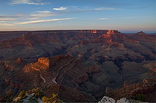
Grand Canyon National Park, located in northwestern Arizona, is the 15th site in the United States to have been named as a national park. The park's central feature is the Grand Canyon, a gorge of the Colorado River, which is often considered one of the Wonders of the World. The park, which covers 1,217,262 acres of unincorporated area in Coconino and Mohave counties, received more than six million recreational visitors in 2017, which is the second highest count of all American national parks after Great Smoky Mountains National Park. The Grand Canyon was designated a World Heritage Site by UNESCO in 1979. The park celebrated its 100th anniversary on February 26, 2019.

Colorado National Monument is a National Park Service unit near the city of Grand Junction, Colorado. Sheer-walled canyons cut deep into sandstone and granite–gneiss–schist rock formations. This is an area of desert land high on the Colorado Plateau, with pinyon and juniper forests on the plateau. The park hosts a wide range of wildlife, including red-tailed hawks, golden eagles, ravens, jays, desert bighorn sheep, and coyotes. Activities include hiking, horseback riding, road bicycling, and scenic drives; a visitor center on the west side contains a natural history museum and gift shop. There are scenic views from trails, Rim Rock Drive, which winds along the plateau, and the campground. Nearby are the Book Cliffs and the largest flat-topped mountain in the world, the Grand Mesa.

Walnut Canyon National Monument is a United States National Monument located about 10 mi (16 km) southeast of downtown Flagstaff, Arizona, near Interstate 40. The canyon rim elevation is 6,690 ft (2,040 m); the canyon's floor is 350 ft lower. A 0.9 mi (1.4 km) long loop trail descends 185 ft (56 m) into the canyon passing 25 cliff dwelling rooms constructed by the Sinagua, a pre-Columbian cultural group that lived in Walnut Canyon from about 1100 to 1250 AD. Other contemporary habitations of the Sinagua people are preserved in the nearby Tuzigoot and Montezuma Castle national monuments.

The Black Ridge Canyons Wilderness (BRCW) is located in western Colorado with a small portion extending into eastern Utah, USA, within the arid Colorado Plateau region approximately 15 miles (24 km) west of Grand Junction, Colorado. The wilderness lies on the northwest flank of the Uncompahgre Plateau. It is characterized by the high, east-west trending Black Ridge dissected by seven major canyon systems, draining into the Colorado River in Ruby Canyon. Elevations range from 4,700 feet (1,400 m) above sea level along the river to 6,800 feet (2,070 m). Canyons vary in length from several miles to twelve miles in length and may contain interesting side canyons. Geological features in these canyons include spires, windows, giant alcoves and desert varnish. Canyons may reach a depth of almost 1,000 feet (300 m), forming spectacular redrock cliffs. Spring runoff and summer thunderstorms create glistening waterfalls and plunge pools. Rattlesnake Canyon contains the second largest concentration of natural arches in the country. Mee Canyon is even more remote, and contains Arch Tower.

The Cape Final Trail is a hiking trail on the North Rim of the Grand Canyon National Park, located in the U.S. state of Arizona.

The Tonto Trail is a hiking trail on the South Rim of the Grand Canyon in Grand Canyon National Park, located in the U.S. state of Arizona.

The Plateau Point Trail is a hiking and pack trail located on the South Rim of the Grand Canyon National Park, located in the U.S. state of Arizona.

The Tanner Trail is a hiking trail located on the South Rim of the Grand Canyon National Park, located in the U.S. state of Arizona. The trailhead is located at Lipan Point, a prominent lookout located to the east of the Grand Canyon Village, and the trail ends at the Colorado River at Tanner Rapids.

John Harvey Butchart was a mathematics professor who was well known for his hiking exploits in and around the Grand Canyon in Arizona, United States. Beginning in 1945, Butchart explored the Grand Canyon's backcountry on foot. He wrote extensively about his adventures and influenced generations of canyoneers.
The Grand Canyon National Park is a U.S. National Park located in the state of Arizona. The Park encompasses the Grand Canyon and the surrounding rim areas. The Park maintains an intricate trail system both above and below the rims of the canyon. To properly maintain and supervise the many trails and campgrounds in the backcountry of the Grand Canyon, Park implemented a system of zoning the different areas of the canyon and the surrounding rim area into backcountry "use areas," designated by a two-letter, one-number code system.
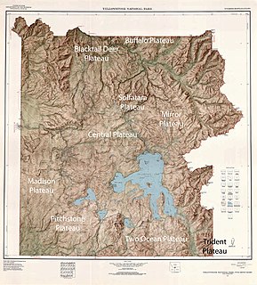
There are nine named plateaus in Yellowstone National Park. These plateaus are part of the much larger Yellowstone Plateau and dominate areas in the park south and west of the Gallatin and Absaroka mountain ranges. Four of the plateaus are from rhyolite lava flows that occurred between 110,000 and 70,000 years ago.
The Berry Creek Trail is a 12-mile (19 km) long hiking trail in the far northern region of Grand Teton National Park in the U.S. state of Wyoming. The trail begins at the National Park Service patrol cabin north of Wilcox Point on Jackson Lake and extends to Jackass Pass at the border between the park and Caribou-Targhee National Forest. Located in the remote northern backcountry of Grand Teton National Park, the trail is not connected to maintained trails in the southern part of the park and must be accessed from the Glade Creek trailhead in the John D. Rockefeller, Jr. Memorial Parkway. From Glade Creek, it is a 7.5 mi (12.1 km) hike to the Berry Creek Trail and then another 6.7 mi (10.8 km) to Jackass Pass. The Berry Creek Trail provides the easiest access to Survey Peak. The trail requires numerous stream crossings which can be dangerous during spring melt.
The Owl Creek Trail is a 7.3-mile (11.7 km) long hiking trail in the far northern region of Grand Teton National Park in the U.S. state of Wyoming. The trail begins at a junction on the Berry Creek Trail and traverses west then south to Moose Basin Divide where it meets the Webb Canyon Trail. Located in the remote northern backcountry of Grand Teton National Park, the trail is not connected to maintained trails in the southern part of the park and must be accessed from the Glade Creek trailhead in the John D. Rockefeller, Jr. Memorial Parkway. From Glade Creek, it is a 7.5 mi (12.1 km) hike to the Berry Creek Trail and then another 4 mi (6.4 km) to the trail junction. The Owl Creek Trail follows Owl Creek west then south and passes south of Forellen Peak. The trail requires numerous stream crossings which can be dangerous during spring melt.
The Webb Canyon Trail is a 9.9-mile (15.9 km) long hiking trail in the far northern region of Grand Teton National Park in the U.S. state of Wyoming. The trail begins near the National Park Service backcountry patrol cabin near Wilcox Point on Jackson Lake. Located in the remote northern backcountry of Grand Teton National Park, the trail is not connected to maintained trails in the southern part of the park and must be accessed from the Glade Creek trailhead in the John D. Rockefeller, Jr. Memorial Parkway. From Glade Creek, it is a 7.5 mi (12.1 km) hike to the patrol cabin and the beginning of the Webb Canyon Trail. The trail follows Moose Creek west and after several miles, is flanked by both Owl Peak and Elk Mountain to the north and several unnamed peaks nearing 11,000 ft (3,400 m) to the south. At Moose Basin Divide the trail meets the Owl Creek Trail.
The Death Canyon Trail is a 10.5 mi (16.9 km) long hiking trail in Grand Teton National Park in the U.S. state of Wyoming. The trail begins west of the White Grass Ranger Station Historic District and ends at Fox Creek Pass where it intercepts the Teton Crest Trail. The trail follows the length of Death Canyon. To get to the trail, the Valley Trail must be accessed at the White Grass Grass Ranger Station then by trending westward just to the north of Phelps Lake. Near Phelps Lake Overlook, the Death Canyon Trail heads west and is flanked by Albright Peak to the north and Prospectors Mountain to the south. After over 2 mi (3.2 km), the canyon widens and is intercepted by the Alaska Basin Trail. The Death Canyon Trail continues west then southwest, climbing steadily to Fox Creek Pass. The camping zone in the canyon extends from just west of the Alaska Basin Trail junction to .5 mi (0.80 km) below Fox Creek Pass and is available by permit.
Newton Butte, in the Grand Canyon, Arizona, United States is a prominence below the South Rim, northwest of Grandview Point, and north on a ridgeline from Shoshone Point which is one mile east of Yaki Point, East Rim Drive. Shoshone Point and Yaki are both on access roads from East Rim Drive, with Yaki being the more advantageous to different viewing directions.

The Grand Canyon Supergroup is a Mesoproterozoic to a Neoproterozoic sequence of sedimentary strata, partially exposed in the eastern Grand Canyon of Arizona. This group comprises the Unkar Group, Nankoweap Formation, Chuar Group and the Sixtymile Formation, which overlie Vishnu Basement Rocks. Several notable landmarks of the Grand Canyon, such as the Isis Temple and Cheops Pyramid, and the Apollo Temple, are surface manifestations of the Grand Canyon Supergroup.
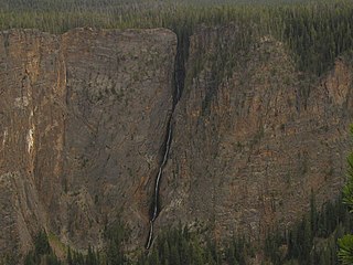
Silver Cord Cascade is a horsetail type waterfall on Surface Creek, a tributary of the Yellowstone River in Yellowstone National Park. Surface Creek flows out of Ribbon Lake off the South rim of the Grand Canyon of the Yellowstone and plunges 1,200 feet (370 m) to the Yellowstone River. It is considered the tallest waterfall in Yellowstone.
References
- ↑ National Geographic Maps Trails Illustrated – Grand Canyon National Park (Map) (1999 ed.). 1: 73,530. National Geographic Maps – Trails Illustrated. § :Walhalla Plateau. ISBN 0-925873-07-1 . Retrieved 2008-07-24.
- ↑ hewit.unco.edu/DOHIST Retrieved 24 February 2012