The South Kaibab Trail is a hiking trail in Grand Canyon National Park, located in the U.S. state of Arizona. Unlike the Bright Angel Trail which also begins at the south rim of the Grand Canyon and leads to the Colorado River, the South Kaibab Trail follows a ridge out to Skeleton Point allowing for 360-degree views of the canyon.

The Bright Angel Trail is a hiking trail located in Grand Canyon National Park in the U.S. state of Arizona.

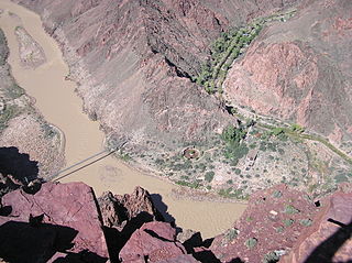
Phantom Ranch is a lodge inside Grand Canyon National Park in Arizona. It sits at the bottom of Grand Canyon, on the east side of Bright Angel Creek, a little over half a mile north of the Creek's confluence with the Colorado River. Opened in 1922, Phantom Ranch is a member of Historic Hotels of America, the official program of the National Trust for Historic Preservation.

The Arizona Strip is the part of Arizona lying north of the Colorado River. The difficulty of crossing the Grand Canyon causes this region to have more physical and cultural connections with southern Utah and Nevada than with the rest of Arizona. The largest settlements in the Strip are Colorado City, Fredonia and Beaver Dam with its surrounding communities of Scenic, Littlefield and Desert Springs.
The North Kaibab Trail is a hiking trail in the North Rim side of the Grand Canyon, in Grand Canyon National Park, located in the U.S. state of Arizona.

Template:Short descriotion

The River Trail is a hiking trail in Grand Canyon National Park, located in the U.S. state of Arizona. This trail connects the end of the Bright Angel Trail with Phantom Ranch and the South Kaibab Trail.

The Boucher Trail is a hiking trail of the South Rim in Grand Canyon National Park, located in the U.S. state of Arizona.

The Plateau Point Trail is a hiking and pack trail located on the South Rim of the Grand Canyon National Park, located in the U.S. state of Arizona.
The Grandview Trail is a hiking trail located on the South Rim of the Grand Canyon National Park, located in the U.S. state of Arizona.It was built in 1893 by miners and is noted for its cobblestone and cribbing sections.

The South Bass Trail is a hiking trail located on the South Rim of the Grand Canyon National Park, located in the U.S. state of Arizona.

The Trans-Canyon Telephone line in Grand Canyon National Park crosses the Grand Canyon from the South Rim to the North Rim via the Inner Canyon. On the south side of the Canyon, the phone line left the South Rim developed area by Bright Angel Lodge, went down Pipe Creek, and crossed the Colorado River. On the north side, the phone line followed Bright Angel Creek up to the rim to the Wylie Way Tourist Camp before the construction of the Grand Canyon Inn. The line was in place by 1924 and was altered in 1938-39 by the Civilian Conservation Corps. It has been unchanged since then. Telephone lines are supported using 592 assemblies of 2-inch (5.1 cm) galvanized pipes and fittings, which could be easily transported and assembled with minimal impact to the canyon environment. It is a rare surviving example of open-wire copper -weld technology. The line extends for 18 miles (29 km), paralleling the Bright Angel Trail and the North Kaibab Trail, providing a direct link between the North and South Rims, as well as the Inner Canyon. A spur line ran along the South Kaibab Trail to the Tipoff.
The Great Western Trail is a north-south long distance multiple use route which runs from Canada to Mexico through five western states in the United States. The trail has access for both motorized and non-motorized users and traverses 4,455 miles (7,170 km) through Arizona, Utah, Idaho, Wyoming, and Montana. Designated a National Millennium Trail.
Newton Butte, in the Grand Canyon, Arizona, United States is a prominence below the South Rim, northwest of Grandview Point, and north on a ridgeline from Shoshone Point which is one mile east of Yaki Point, East Rim Drive. Shoshone Point and Yaki are both on access roads from East Rim Drive, with Yaki being the more advantageous to different viewing directions.

Isis Temple, in the Grand Canyon, Arizona, USA, is a prominence below the North Rim, and adjacent to Granite Gorge. The prominence lies north of the north bank of the west-flowing Colorado River and is just north of Granite Gorge. The Trinity Creek and canyon flow due-south at its west border; its north, and northeast border/flank is formed by Phantom Creek and canyon, a west tributary of Bright Angel Creek; the creeks intersect about 3 mi southeast, and 1 mi north of Granite Gorge. The Isis Temple prominence, is only ~202 ft lower than Grand Canyon Village, the main public center on Grand Canyon’s South Rim.

The Grand Canyon Supergroup is a Mesoproterozoic to Neoproterozoic sequence of sedimentary strata, mostly exposed in the eastern Grand Canyon of Arizona. This group is composed of the Unkar Group, Nankoweap Formation, Chuar Group and the Sixtymile Formation, which overlie Vishnu Basement Rocks. Several notable landmarks of the Grand Canyon, such as the "Isis Temple and Cheops Pyramid" and the "Apollo Temple," are surface manifestations of the Grand Canyon Supergroup.

Located directly downstream of the Little Colorado River confluence with the Colorado River, the Tanner Graben, in the Grand Canyon, Arizona, USA is a prominence and cliffside rock formation below the East Rim. Tanner Graben is located riverside, on the Colorado River, on a north-northwest bank at Mile 68.5, and lies opposite Tanner Canyon. The Tanner Rapid, created by Tanner Creek lies at the riverside foot of the graben. The graben is a pronounced feature because of the black Cardenas Basalt that forms the middle section of the graben, presumably free of debris accumulation by its cliff face steepness, and winds, and airflow drainage that course through the Colorado River's canyons; unprotected side canyons of Cardenas Basalt show accumulations as a slope-forming geologic unit, with little showing of black basalt.

Zoroaster Temple is a 7,123-foot-elevation summit located in the Grand Canyon, in Coconino County of Arizona, USA. It is situated 5.5 miles northeast of the Yavapai Point overlook on the canyon's South Rim, from which it can be seen towering over 4,600 feet above the Colorado River and Granite Gorge. Its nearest higher neighbor is Brahma Temple, less than one mile to the north-northeast. Zoroaster Temple is named for Zoroaster, an ancient Iranian prophet. This name was used by George Wharton James and Clarence Dutton. Dutton began the tradition of naming geographical features in the Grand Canyon after mythological deities. This geographical feature's name was officially adopted in 1906 by the U.S. Board on Geographic Names.
The first ascent of the summit was made by Rick Tidrick and Dave Ganci in September 1958 via the NE Arete (class 5.9+). Other climbing routes include Screaming Sky Crack, and SE Face, a challenging class 5.11+ route that was first climbed in 2012. The 1958 Zoroaster ascent was the first technical climb in the Grand Canyon, transforming the Grand Canyon into a climbing mecca and setting off a rush to climb the many summits. According to the Köppen climate classification system, Zoroaster Temple is located in a Cold semi-arid climate zone.

Swilling Butte is a 6,785-foot (2,068 m)-elevation ridgeline summit located in the eastern Grand Canyon, in Coconino County of northern Arizona, United States. The landform is in a group of nearby summits, Colter Butte, west, and Hutton and Duppa Buttes, east. All four buttes are at the north of the east-flowing Kwagunt Creek and Canyon drainage to the Colorado River. Swilling Butte is 3.0 miles (4.8 km) northeast of Atoko Point, East Rim of the Walhalla Plateau, and 4.0 miles (6.4 km) west of the (north)-East Rim, Grand Canyon; the south-flowing Colorado River is west and adjacent to the East Rim. Swilling Butte is a triangular-platform summit of bright-red, tall Redwall Limestone. Being a cliff-former, the Redwall is also a platform-former. The upper platform of the Redwall Limestone supports a remainder-debris of the Supai Group. Of the two lower units, no. 2 is a cliff-former, hard rocks (cliffs), of the Manakacha Formation; the slope-former,, the Watahomigi Formation, forms most of the Supai debris upon the Redwall. Below the Redwall Limestone are members of the Cambrian Tonto Group, the Muav Limestone and the slopes of the Bright Angel Shale.

Topaz Canyon is a linear, narrow canyon in western Grand Canyon, below the South Rim. It lies in a region of four canyons, and a fifth smaller canyon, all trending mostly northeasterly towards the west-flowing Colorado River, in western Grand Canyon National Park. The name of Topaz Canyon was named by the Board of Geographical Names for precious stones of the region. Topaz Canyon is the southeast border of the linear major forested-landform, Diana Temple; .
The northeast terminus of Topaz Canyon intersects with the outfall of Boucher Canyon and the tract of the Tonto Trail. The Boucher Trail starting in Hermit Canyon,, ends at the termini of both Topaz and Boucher Canyons.

