Related Research Articles

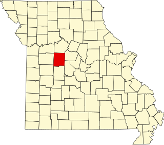
Morgan County is a county located in the central portion of the U.S. state of Missouri. As of the 2020 census, the population was 21,006. Its county seat is Versailles. The county was organized January 5, 1833 and named for General Daniel Morgan of the American Revolutionary War.

Morse Mill is an unincorporated community in western Jefferson County, Missouri, United States. It is located approximately five miles northwest of Hillsboro along Missouri Route B. The community and mill were located along Big River.
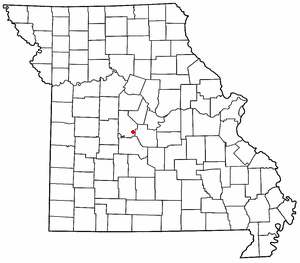
Rocky Mount is an unincorporated community in eastern Morgan County, Missouri, United States. It is located six miles southwest of Eldon, near the Lake of the Ozarks. The ZIP Code for Rocky Mount is 65072.
Newland is an unincorporated community in northeast Pettis County, in the U.S. state of Missouri. The community is on Missouri Route EE approximately eight miles northeast of Sedalia.
Petersburg is an unincorporated community in Henry County, in the U.S. state of Missouri.
Cureall is an unincorporated community in Howell County, in the U.S. state of Missouri.
Bowmansville was an unincorporated community in Johnson County, in the U.S. state of Missouri.
Valley City is an unincorporated community in northeast Johnson County, in the U.S. state of Missouri.
Aikinsville is an unincorporated community in Morgan County, in the U.S. state of Missouri.
Glensted is an unincorporated community in Morgan County, in the U.S. state of Missouri.
Marvin is an unincorporated community in Morgan County, in the U.S. state of Missouri.
Proctor is an unincorporated community in southwest Morgan County, in the U.S. state of Missouri.
Pyrmont is an unincorporated community in western Morgan County, in the U.S. state of Missouri. The community is located just east of Missouri Route 135 approximately midway between Stover to the south and Florence to the northeast. Gabriel Creek flows past to the east.
Riverview is an unincorporated community in southwestern Morgan County, in the U.S. state of Missouri.
Manila is an unincorporated community in southern Pettis County, in the U.S. state of Missouri.
Cobb is an unincorporated community in St. Clair County, in the U.S. state of Missouri.
Harper is an unincorporated community in St. Clair County, in the U.S. state of Missouri. The community is on Missouri Route 82 approximately ten miles east of Osceola and within one mile of the St. Clair - Hickory county line.
Iuka Springs is an extinct town in St. Clair County, in the U.S. state of Missouri. The GNIS classifies it as a populated place.
Koester is an unincorporated community in St. Francois County, in the U.S. state of Missouri.
Big Buffalo Creek is a stream in Morgan and Benton counties in west-central Missouri. It is a tributary of the Osage River within the Lake of the Ozarks.
References
- ↑ U.S. Geological Survey Geographic Names Information System: Boylers Mill, Missouri
- ↑ Missouri Atlas & Gazetteer, DeLorme, 1998, First edition, p. 44 ISBN 0-89933-224-2
- ↑ "Post Offices". Jim Forte Postal History. Retrieved November 17, 2016.
- ↑ "Morgan County Place Names, 1928–1945". The State Historical Society of Missouri. Archived from the original on June 24, 2016. Retrieved November 17, 2016.
Municipalities and communities of Morgan County, Missouri, United States | ||
|---|---|---|
| Cities |  | |
| Villages | ||
| Townships | ||
| Unincorporated communities | ||
| Ghost town | ||
| Footnotes | ‡This populated place also has portions in an adjacent county or counties | |
38°20′50″N93°04′15″W / 38.34722°N 93.07083°W
| | This Morgan County, Missouri state location article is a stub. You can help Wikipedia by expanding it. |