Related Research Articles
Roby is an unincorporated community in northwestern Texas County, Missouri, United States. It is located approximately sixteen miles northwest of Houston and ten miles south of Fort Leonard Wood at the northern junction of Routes 17 and 32. Roby is home to the "Mark Twain National Forest" campgrounds.
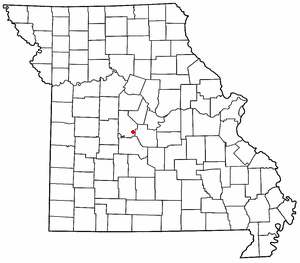
Rocky Mount is an unincorporated community in eastern Morgan County, Missouri, United States. It is located six miles southwest of Eldon, near the Lake of the Ozarks. The ZIP Code for Rocky Mount is 65072.
Purvis is an unincorporated community in northern Camden County, in the U.S. state of Missouri. The community is located on the north shore of the Lake of the Ozarks. The Purvis cemetery is located to the southwest across the Brush Creek arm of the lake. The community of Laurie is located on Missouri Route 5 and is approximately two miles to the north, in Morgan County.
Harold is an unincorporated community in northwest Greene County, in the U.S. state of Missouri. Harold is located on Missouri Route 123, southeast of Walnut Grove and 1.5 miles east of Phenix.
Galesburg is an unincorporated community in northwest Jasper County in southwest Missouri, United States. The community is located on the south bank of the Spring River, approximately twelve miles north of Joplin.
Owsley is an unincorporated community in eastern Johnson County, in the U.S. state of Missouri.
Atwell is an unincorporated community in the southeast corner of Miller County, in the U.S. state of Missouri. The community is on a low ridge between Atwell Creek to the east and Little Tavern Creek to the west. Access is by Missouri Route K from Missouri Route 17. Iberia is 5.5 miles to the northwest.
Hoecker is an unincorporated community in northeast Miller County, in the U.S. state of Missouri. The community is on a meander of the Osage River just south of the Miller-Cole county line. Henley is two miles to the west-northwest in Cole County and Meta is six miles to the east in Osage County.
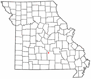
Rocky Mount is an unincorporated community in western Miller County, Missouri United States. The site is on Missouri Route Y approximately four miles southwest of Eldon. The Rocky Mount church is located at this location, however the post office was moved into neighboring Morgan County about two miles to the southwest in 1919. The Rocky Mount Lookout Tower and Rocky Mount Towersite State Wildlife Area lie approximately two miles to the east.
Bacon is an unincorporated community in northeast Moniteau County, in the U.S. state of Missouri. The community is on Moniteau Creek approximately seven miles northeast of California.
Aikinsville is an unincorporated community in Morgan County, in the U.S. state of Missouri.
Boylers Mill is an unincorporated community in western Morgan County, in the U.S. state of Missouri. The community is in Pole Hollow just north of the Big Buffalo Creek. The site is on Missouri Route FF.
Buck Creek is a stream in Morgan County in the U.S. state of Missouri. It is a tributary to the Osage River within the Lake of the Ozarks.
Buck Creek is an unincorporated community in Morgan County, in the U.S. state of Missouri. The community is on Missouri Route O about four miles northeast of Laurie. The location is just west of the Gravois Creek Arm of the Lake of the Ozarks.
Marvin is an unincorporated community in Morgan County, in the U.S. state of Missouri.
Proctor is an unincorporated community in southwest Morgan County, in the U.S. state of Missouri.
Pyrmont is an unincorporated community in western Morgan County, in the U.S. state of Missouri. The community is located just east of Missouri Route 135 approximately midway between Stover to the south and Florence to the northeast. Gabriel Creek flows past to the east.
Riverview is an unincorporated community in southwestern Morgan County, in the U.S. state of Missouri.
Todd is an extinct town in Morgan County, in the U.S. state of Missouri.
Buffalo Township is a township in Morgan County, in the U.S. state of Missouri.
References
- ↑ U.S. Geological Survey Geographic Names Information System: Glensted, Missouri
- ↑ "Post Offices". Jim Forte Postal History. Retrieved November 17, 2016.
- ↑ "Morgan County Place Names, 1928–1945". The State Historical Society of Missouri. Archived from the original on June 24, 2016. Retrieved November 17, 2016.
Municipalities and communities of Morgan County, Missouri, United States | ||
|---|---|---|
| Cities |  | |
| Villages | ||
| Townships | ||
| Unincorporated communities | ||
| Ghost town | ||
| Footnotes | ‡This populated place also has portions in an adjacent county or counties | |
38°30′56″N92°51′20″W / 38.51556°N 92.85556°W
| | This Morgan County, Missouri state location article is a stub. You can help Wikipedia by expanding it. |