
Preston is a village and civil parish about 3 miles (4.8 km) south of Hitchin in Hertfordshire, England. At the 2011 Census the population was 420.

Holwell is a small village and a civil parish two miles north of Hitchin in Hertfordshire, England, near the Bedfordshire border. At the 2011 Census the population of the village was 362. The church is unusual and, although largely rebuilt, retains some Perpendicular features and an interesting brass to Richard Wodehouse. The school, almshouses, and rectory are all in a similar Tudor style erected in the 1830s, but are no longer in use and have been converted into housing. Fragments of early wall paintings and wooden mullioned windows have been discovered in the mediaeval timber-framed Church Farmhouse.

Great Wymondley is a village situated near Hitchin in Hertfordshire, England. Despite the names, Great Wymondley is a smaller settlement than its neighbour, Little Wymondley. It is in the civil parish of Wymondley.

Ardeley is a small village and civil parish in East Hertfordshire, England. The parish includes the hamlet of Cromer, as well as Wood End and Moor Green.

Bramfield is a village and civil parish in the east of the English county of Suffolk. It is 5 miles (8.0 km) south of the market town of Halesworth on the A144 road between Halesworth and the A12 road, one of the main arterial routes through the county. The village is 24 miles (39 km) north-east of the county town of Ipswich and 15 miles (24 km) south-west of the port of Lowestoft. The East Suffolk railway line between Lowestoft and Ipswich passes close to the west of the village with Halesworth railway station being the nearest station.

Buckland is a village and civil parish in the East Hertfordshire district of Hertfordshire, England. According to the 2011 census it had a population of 274. The civil parish containing the village had a population of 1,853 at the 2011 census. The village is about 4½ miles south of Royston on the A10 road.

Ridge is a village and civil parish in the Hertsmere borough of Hertfordshire, situated between Potters Bar and Shenley. At the 2011 Census the village was a civil parish in its own name. The population of the parish was 177. It has a church, St Margaret's; a children's playground; and the Old Guinea public house, which serves food on most days. The village holds an annual fete on the August bank holiday. Ridge is surrounded by countryside with numerous public footpaths. In 1926, the parish boundary between Ridge, Hertfordshire, and South Mimms, Middlesex, was subject to a minor adjustment.
Northaw is a village in the Welwyn Hatfield district of Hertfordshire, England. It is part of the civil parish of Northaw and Cuffley, which was originally known as Northaw.
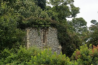
Benington Castle is a ruined castle in the village of Benington, near Stevenage in Hertfordshire, England at grid reference TL296236. It has been protected since 1936 as a scheduled ancient monument.
Sele Farm is an area on the north-western edge of Hertford, Hertfordshire.

The Church of Saint Leonard is a Norman church in Bengeo, Hertfordshire. Located on the hillside overlooking the shared Beane and Lea valley, the Grade I Listed church dates from about 1120, and is the oldest building in Hertford. The church served as the parish church of Bengeo until the larger Holy Trinity Church was opened in 1855. St. Leonard's was stripped of its fittings and stood empty and unused for some years, until the Gosselin family of nearby Bengeo Hall commissioned its restoration and refitting between 1884 and 1894.
Hertford Rural District was a rural district in the county of Hertfordshire, England. It was created in 1894. On 1 April 1974 it was abolished under the Local Government Act 1972, and has since formed part of the District of East Hertfordshire.

Great Munden is a village and civil parish in Hertfordshire, England. The parish, in the district of East Hertfordshire, spans 3,758 acres (5.872 sq mi), of which 1,895.75 acres (2.96211 sq mi) are arable land, 927.5 acres (1.4492 sq mi) are permanent grass and 97 acres (0.152 sq mi) are wood. It has a population of 477, reducing to 339 at the 2011 Census, and is situated 6 miles (9.7 km) north of the town of Ware. The village includes the church of St Nicholas, Munden Bury, and a rectory that includes the remains of a moat. Other settlements in the parish include Nasty and Levens Green. A detached portion of Little Munden was added to the parish in 1888.
Sacombe is a village and civil parish and East Hertfordshire district, of Hertfordshire, England. At the 2001 census it had a population of 165. Sacombe is located about 4 miles N N W of Ware; other nearby settlements include Dane End and Sacombe Green.

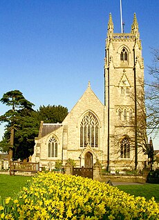
Sandon is a village and civil parish in the North Hertfordshire district, in the county of Hertfordshire, England. Sandon is located near the towns of Baldock and Buntingford. The parish also includes the hamlets of Green End and Roe Green, and Blagrove Common, a nature reserve. At the 2011 Census the population of the civil parish was 495. Sandon has a church called All Saints Church. Sandon has 47 listed buildings, including one of Britain’s estimated 200 medieval barns, the construction of which has been dendrochronologically dated to 1266-68.
St. Andrew's Church is a 13th-century church in Bramfield, Suffolk. It has a separate 12th-century tower standing in the church grounds. It is one of 38 existing round-tower churches in Suffolk and the only detached example in the county. The ground before the altar of the church is paved with a number of fine ledger slabs of members of the Rabett and Nelson families.

The Chipping Barnet War Memorial is located immediately west of St John the Baptist Church in Wood Street, Chipping Barnet, Greater London. It commemorates the men of the district who died in the first and second World Wars and is in the form of an octagonal base below a pedestal surmounted by a tapering column with a Celtic cross head. The cross is intersected by a corona in a flattened octagonal section. It was unveiled by Lord Byng of Vimy in April 1921. Byng was born at nearby Wrotham Park in Hertfordshire.

The Horns is a public house in Datchworth, Hertfordshire, England. It is situated on Bramfield Road in Bull's Green, a hamlet in the parish of Datchworth.

The Lytton Mausoleum is a family mausoleum in Knebworth Park, Hertfordshire, England. It was commissioned by Elizabeth Barbara Lytton and built in 1817.

The Church of St Mary and St Thomas is one of two Anglican churches in Knebworth, Hertfordshire, England. The church dates from the twelfth century and is a grade I listed building.


