Gilston

Last updated

Gilston
St. Mary's Church, Gilston - geograph.org.uk - 140191.jpg
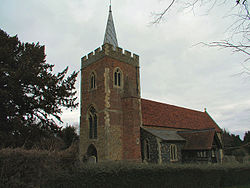
St Mary's church, Gilston
Hertfordshire UK location map.svg
Red pog.svg
Gilston
Location within Hertfordshire
Population228 (2011 Census) [1]
OS grid reference TL 448 121
Civil parish
  • Gilston
District
Shire county
Region
Country England
Sovereign state United Kingdom
Post town HARLOW
Postcode district CM20
Dialling code 01279
Police Hertfordshire
Fire Hertfordshire
Ambulance East of England
UK Parliament
List of places
UK
England
Hertfordshire
51°47′23″N0°05′58″E / 51.7896014°N 0.099346°E / 51.7896014; 0.099346

Gilston is a village and civil parish in the East Hertfordshire district of Hertfordshire, England. It is located a little over one mile north of the town of Harlow in the neighbouring county of Essex. Together with the nearby village of Eastwick, it forms the parish council of Eastwick and Gilston Parish Council. It is within the Hunsdon ward of East Hertfordshire District Council. At the 2001 Census, the population was 180, [2] and 228 at the 2011 Census. [1]

Contents

History

The name derives from Gedel or Gydel, an Old English personal name, and tun, meaning farm or settlement. A variation in spelling may be seen as "Gedeleston", in a legal record in 1424. [3]

The Parish Church of St Mary dates from the 13th century, and is Grade I listed. The churchyard includes a listed memorial to the Johnston family, and there is a 17th century tomb of the Gore family of Netherhall and an 18th century tomb of the Turvin family of Terlings Park in the church chancel. The Gore family included a Lord Mayor of London and the Gore and Turvin families both included a High Sheriff of Hertfordshire. [4]

The Plume of Feathers Inn dates from the 18th century. [5]

Gilston Park is a 19th century country house, which is Grade II* listed. It was designed by Philip Charles Hardwick in 1852 and extended by Arthur Blomfield in 1887, with later work by Blomfield's son, A C Blomfield. [6] It was later home to the Salvin Bowlby family, who founded the Gilston and Eastwick Working Men's Club, now the village hall, in 1908. [4]

See also

Related Research Articles

<span class="mw-page-title-main">Bow Brickhill</span> Civil parish in the City of Milton Keynes, England

Bow Brickhill is a village and civil parish in the unitary authority area of the City of Milton Keynes, Buckinghamshire, England. It is bounded to the north, west and east by the Milton Keynes urban area, approximately 2 miles (3.2 km) east of Fenny Stratford, 1.5 miles (2.4 km) west of Woburn Sands and 4 miles (6.4 km) south-east of Central Milton Keynes.

<span class="mw-page-title-main">Sawbridgeworth</span> Town in Hertfordshire, England

Sawbridgeworth is a town and civil parish in Hertfordshire, England, close to the border with Essex. It is 12 miles (19 km) east of Hertford and 9 miles (14 km) north of Epping. It is the northernmost part of the Greater London Built-up Area.

<span class="mw-page-title-main">Markyate</span> Human settlement in England

Markyate is a village and civil parish in north-west Hertfordshire, close to the border with Bedfordshire and Buckinghamshire.

<span class="mw-page-title-main">Bishops Lydeard</span> Human settlement in England

Bishops Lydeard is a village and civil parish located in Somerset, England, 5 miles (8 km) north-west of Taunton. The civil parish encompasses the hamlets of East Lydeard and Terhill, and had a population of 2,839 persons as recorded in the 2011 census; this figure, however, includes the village of Cotford St Luke.

<span class="mw-page-title-main">Adwell</span> Human settlement in England

Adwell is a village and civil parish about 3 miles (5 km) south of Thame in South Oxfordshire. The parish covers 443 acres (179 ha),

<span class="mw-page-title-main">North Mymms</span>

North Mymms is a civil parish in the English county of Hertfordshire. At the 2011 Census the civil parish had a population of 8,921.

<span class="mw-page-title-main">Tewin</span> Village in Hertfordshire, England

Tewin is an English village and civil parish in Hertfordshire, England between the towns of Welwyn Garden City, Stevenage, Welwyn (village) and the county town Hertford. It is within commuting distance of London with trains taking under 30 minutes from Welwyn North station to Central London. Tewin Wood is a very affluent residential area in Tewin and ranked amongst the most expensive areas in the UK with average property prices in many streets well in excess of £2 million.

<span class="mw-page-title-main">Ardeley</span> Human settlement in England

Ardeley is a small village and civil parish in East Hertfordshire, England. The parish includes the hamlet of Cromer, as well as Wood End and Moor Green.

<span class="mw-page-title-main">Brocklesby</span> Village and civil parish in Lincolnshire, England

Brocklesby is a village and civil parish in the West Lindsey district of Lincolnshire, England. It is situated 1 mile (1.6 km) south from Habrough, 4 miles (6.4 km) south-west from Immingham, and is located close to the border of both North Lincolnshire and North East Lincolnshire and is near Humberside International Airport.

<span class="mw-page-title-main">Buerton, Cheshire East</span> Human settlement in England

Buerton is a village at SJ685435 and civil parish in the unitary authority of Cheshire East and the ceremonial county of Cheshire, England, about 7 miles south of the town of Nantwich and 1½ miles east of the village of Audlem, on the border with Shropshire. The parish also includes the small settlements of Hankins Heys, Moblake, Pinder's End and Three Wells, as well as parts of Chapel End, College Fields, Kinsey Heath, Longhill, Raven's Bank, Sandyford and Woolfall. In 2001, the total population was a little under 500, which had increased marginally to 503 at the 2011 Census. Nearby villages include Adderley, Audlem, Bridgemere, Hankelow, Hatherton, Hunsterson and Woore.

<span class="mw-page-title-main">Sotterley</span> Human settlement in England

Sotterley, originally Southern-lea from its situation south of the river, is a village and civil parish in the East Suffolk district, in the English county of Suffolk, located approximately 4 miles (6 km) south-east of Beccles and 1.5 miles (2 km) east of Willingham St Mary and Shadingfield. The parish is primarily agricultural with a dispersed population of 113 at the 2011 census. The parish council operates to administer jointly the parishes of Shadingfield, Willingham St Mary, Sotterley and Ellough.

<span class="mw-page-title-main">Bransgore</span> Human settlement in England

Bransgore is a village and civil parish within the New Forest District, Hampshire, England. The village developed in the 19th century when a church and a school were built. It is technically classified as an urban area, although in some respects it still has the picturesque character of a rural English village.

<span class="mw-page-title-main">Dalton Holme</span> Civil parish in the East Riding of Yorkshire, England

Dalton Holme a civil parish in the East Riding of Yorkshire in England. It is situated 5 miles (8 km) to the north-west from the market town of Beverley and covering an area of 1,360.063 hectares.

<span class="mw-page-title-main">Crewe Green</span> Human settlement in England

Crewe Green is a small village and former civil parish, now in the parish of Weston and Crewe Green, in the unitary authority area of Cheshire East and the ceremonial county of Cheshire, England. The village lies 1½ miles to the east of the centre of Crewe. The parish also includes a dispersed settlement of houses and farms called Slaughter Hill, the Jacobean mansion of Crewe Hall, and the industrial estates of Crewe Hall Enterprise Park and Crewe Hall Farm. Nearby villages include Haslington and Stowford.

<span class="mw-page-title-main">Hunsterson</span> Human settlement in England

Hunsterson is a hamlet and former civil parish, now in the parish of Doddington and District, in the unitary authority area of Cheshire East and the ceremonial county of Cheshire, England. The hamlet is located 2¾ miles to the north east of Audlem and 6 miles to the south of Crewe. The parish also included the settlements of Brown Moss, Four Lane End, Foxes Bank and Whittaker's Green. In 2011 the parish had a population of 163. Nearby villages include Audlem, Buerton, Hatherton and Hankelow.

<span class="mw-page-title-main">Cottered</span> Human settlement in England

Cottered is a village and civil parish 3 miles (4.8 km) west of Buntingford and 6 miles (9.7 km) east of Baldock in the East Hertfordshire District of Hertfordshire in England. It had a population of 634 in 2001, increasing to 659 at the 2011 Census.

<span class="mw-page-title-main">Hertingfordbury</span> Village in Hertfordshire, England

Hertingfordbury is a small village in Hertfordshire, England, close to the county town of Hertford. It was mentioned in the Domesday Book of 1086. Hertingfordbury is also the name of a neighbouring civil parish, which does not contain the village. Hertingfordbury Village is located within the Castle ward of local government Hertford Town Council. The population of the civil parish as of the 2021 census was 689.

<span class="mw-page-title-main">St James' Church, Stanstead Abbotts</span> Church in Hertfordshire, England

St James' Church is a redundant Anglican church near the village of Stanstead Abbotts, Hertfordshire, England. It is recorded in the National Heritage List for England (NHLE) as a Grade I listed building, having been designated in 1967. The church is under the care of the Churches Conservation Trust. The church is about 1 mile (1.6 km) to the southeast of the village on the north side of the B181 road. It stands on the top of a hill overlooking the Lea marshes.

<span class="mw-page-title-main">All Saints' Church, Hertford</span> Church in Hertfordshire, England

All Saints' Church is in Queens Road, Hertford, Hertfordshire, England. It is an active Anglican parish church in the deanery of Hertford and Ware, the archdeaconry of Hertford, and the diocese of St Albans. It is the civic church of the town and of the county. The church is recorded in the National Heritage List for England as a designated Grade II* listed building. It is the largest church in Hertfordshire, other than St Albans Cathedral, and can seat up to 1,000 people.

<span class="mw-page-title-main">Eastwick, Hertfordshire</span> Human settlement in England

Eastwick is a village and civil parish 7 miles (11 km) east of Hertford, in the East Hertfordshire district, in the county of Hertfordshire, England. In 2011 the parish had a population of 194. The parish touches Gilston, High Wych, Hunsdon and Widford. Eastwick shares a parish council with Gilston.

References

  1. 1 2 "Civil Parish population 2011". Neighbourhood Statistics. Office for National Statistics. Retrieved 28 October 2016.
  2. "Gilston". Luton Paranormal Society. Archived from the original on 16 March 2014. Retrieved 12 September 2012.
  3. the Plea Rolls of the Court of Common Pleas; National Archives; CP40/654; image viewable at: http://aalt.law.uh.edu/AALT1/H6/CP40no654/aCP40no654fronts/IMG_0650.htm [ 5th entry ] with "Hertf" at the left as the county, and Mauricius Bruyn as plaintiff
  4. 1 2 "Parishes: Gilston Pages 319-323 A History of the County of Hertford: Volume 3". British History Online. Retrieved 23 January 2024.
  5. "About us". Plume of Feathers. Retrieved 23 January 2024.
  6. "Gilston Park". British Listed Buildings. Retrieved 23 January 2024.