Nuthampstead

Last updated

Nuthampstead
Hertfordshire UK location map.svg
Red pog.svg
Nuthampstead
Location within Hertfordshire
Population139 (2001)
142 (2011 Census) [1]
OS grid reference TL411347
District
Shire county
Region
Country England
Sovereign state United Kingdom
Post town Royston
Postcode district SG8
Dialling code 01763
Police Hertfordshire
Fire Hertfordshire
Ambulance East of England
UK Parliament
List of places
UK
England
Hertfordshire
51°59′34″N0°02′28″E / 51.9928°N 0.0410°E / 51.9928; 0.0410

Nuthampstead is a small village and civil parish in North East Hertfordshire located a few miles south of the town of Royston. In the 2001 census the parish had 139 residents, [2] increasing to 142 at the 2011 Census. [1]

Contents

Nuthampstead was historically a hamlet in the parish of Barkway. The hamlet appointed its own overseer of the poor, [3] and as such became an separate civil parish on 10 August 1866 under the Poor Law Amendment Act 1866. Despite becoming a separate civil parish, it remains part of the ecclesiastical parish of Barkway. [4] Nuthampstead was included in the Royston Poor Law Union from 1835. [5] It formed part of the Ashwell Rural District from 1894 until 1935, when that district was absorbed into the Hitchin Rural District. Since 1974, Nuthampstead has been part of North Hertfordshire. [6] Due to its small size, Nuthampstead has a parish meeting rather than a parish council. [7]

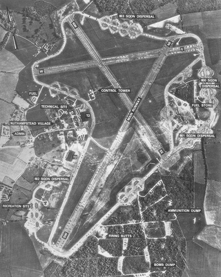
During the Second World War, RAF Nuthampstead, situated next to the village, was home initially to the 55th Fighter Group and subsequently the 398th Bombardment Group of the U.S. Army Air Forces. This latter unit, the base's primary occupant, flew Boeing B-17 Flying Fortress heavy bombers on missions over occupied Europe. [8]

Known as USAAF Station 131 during the war, and less formally as AAF Nuthampstead, the airfield was constructed by U.S. Army engineer battalions starting in 1942. The site was formerly Scales Park, which was planted with oak trees after the Battle of Trafalgar. These were cleared to make room for the runways, hangars, and other wartime facilities. Visitors to the site will find that the main runways have since been removed, with a grass runway and service roads only remaining to allow the airfield to be used by light aircraft.

In 1968–71 the Commission on the Third London Airport (the "Roskill Commission") considered Nuthampstead as one of its four short-listed sites, along with Cublington, Foulness (later known as Maplin Sands) and Thurleigh. [9]

Barkway VOR is located at Nuthampstead Airfield. [10]

Areas of the former airfield have been converted into a shooting ground. Since 1992, when planning permission was granted, the ground has developed to enable it to hold major championships in four international shooting disciplines. [11]

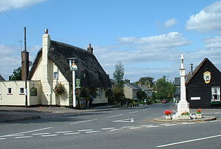
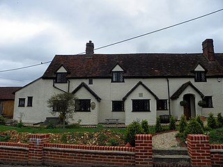
The village has a pub/restaurant with bed and breakfast facilities, called The Woodman Inn. [12] Outside The Woodman Inn is a large memorial stone dedicated to the 398th squadron, and a museum of the airfield's history. [13]

See also

Related Research Articles

<span class="mw-page-title-main">Royston, Hertfordshire</span> Town in Hertfordshire, England

Royston is a town and civil parish in the District of North Hertfordshire and county of Hertfordshire in England.

<span class="mw-page-title-main">Baldock</span> Town in Hertfordshire, England

Baldock is a historic market town in the North Hertfordshire district of Hertfordshire, England. The River Ivel rises from springs in the town. It lies 33 miles (53 km) north of London and 14 miles (23 km) north northwest of the county town of Hertford. Nearby towns include Royston to the northeast, Letchworth and Hitchin to the southwest and Stevenage to the south.

<span class="mw-page-title-main">North Hertfordshire</span> Non-metropolitan district in England

North Hertfordshire is one of ten local government districts in the county of Hertfordshire, England. Its council is based in Letchworth. The district borders East Hertfordshire, Stevenage, Welwyn Hatfield, St Albans, Central Bedfordshire, Luton, and South Cambridgeshire.

<span class="mw-page-title-main">Bovingdon</span> Human settlement in England

Bovingdon is a village in Hertfordshire, England, 4 miles (6.4 km) southwest of Hemel Hempstead, and it is a civil parish within the local authority area of Dacorum. It forms the largest part of the ward of Bovingdon, Flaunden and Chipperfield, which had a population of 4,600 at the 2001 census, increasing to 9,000 at the 2011 Census.

<span class="mw-page-title-main">Hinxworth</span> Human settlement in England

Hinxworth is a village and civil parish in North Hertfordshire, England. It sits just off the Great North Road between Baldock and Biggleswade. It has a village hall, a park, a pub, a small church, a bus stop and a post box. The population at the 2011 Census was 313.

<span class="mw-page-title-main">Therfield</span> Human settlement in England

Therfield is both a small village of approximately 4,761 acres (19 km²) and a civil parish which sits upon the chalk range, three miles southwest of Royston, and six miles (10 km) northeast of Baldock and within the English county of Hertfordshire.

<span class="mw-page-title-main">Ashwell, Hertfordshire</span> Human settlement in England

Ashwell is a village and civil parish in Hertfordshire situated 4 miles (6 km) north-east of Baldock.

<span class="mw-page-title-main">Fowlmere</span> Human settlement in England

Fowlmere is one of the southernmost villages in Cambridgeshire, England. The population of the civil parish at the 2011 Census was 1,206. It is very close to the Imperial War Museum Duxford, and 9 miles (14 km) southwest of the city of Cambridge.

<span class="mw-page-title-main">Barkway</span> Human settlement in England

Barkway is a long-established village and civil parish in the North Hertfordshire district of Hertfordshire, England, about five miles south-east of Royston, 35 miles from London and 15 miles from the centre of Cambridge. The Prime Meridian passes a mile or so to the west of Barkway.

<span class="mw-page-title-main">Barley, Hertfordshire</span> Human settlement in England

Barley is a village and civil parish in the district of North Hertfordshire, England. According to the 2001 census, it has a population of 659, increasing to 662 at the 2011 Census. The place-name refers to a lea or meadow and not to the grain-producing plant. Coincidentally to the southwest lies the village of Reed. The Prime Meridian passes to the west of Barley, which is located on the Royston to Saffron Walden road, as well as the medieval London to Cambridge road.

<span class="mw-page-title-main">Kelshall</span> Human settlement in England

Kelshall is a small village in North East Hertfordshire, England. It is near the town of Royston. It has a village hall and the local church is St Faith's. Kelshall is also the name of the civil parish. Kelshall also has a major road running along one of its boundaries. In the 1880s the church was described as being "ancient, plain, and good, with a tower; and contains a few brasses and monuments".

<span class="mw-page-title-main">RAF Nuthampstead</span>

Royal Air Force Nuthampstead or more simply RAF Nuthampstead is a former Royal Air Force station in England. The airfield is located mostly in Hertfordshire between the villages of Nuthampstead and Anstey and the hamlet of Morrice Green in Hertfordshire and Langley, Lower Green and Clavering Park Wood in Essex. The eastern part of the airfield including part of the East-West Runway, the Fuel Store, the dispersal areas of 600 and 601 Squadrons and the northeastern perimeter track were all in Essex. RAF Nuthampstead is located four miles to the east of the A10 Hertford to Royston road.

<span class="mw-page-title-main">Reed, Hertfordshire</span> Human settlement in England

Reed is a small village and civil parish in North Hertfordshire. It is situated on a chalk ridge, approximately 3 miles (4.8 km) south of the market town of Royston. The Prime Meridian passes just to the east of the village, between Reed and Barkway. The modern A10 road passes just to the west of the village. The population of the parish was 310 at the time of the 2011 census.

<span class="mw-page-title-main">Steeple Morden</span> Human settlement in England

Steeple Morden is a village and civil parish in Cambridgeshire, England, about 15 miles (24 km) south west of Cambridge and 5 miles (8 km) west of Royston. It is part of the South Cambridgeshire local government district.

<span class="mw-page-title-main">Wymondley</span> Human settlement in England

Wymondley is a civil parish in Hertfordshire, England.

<span class="mw-page-title-main">Langley, Hertfordshire</span> Human settlement in England

Langley is a hamlet and civil parish in the non-metropolitan district of North Hertfordshire and county of Hertfordshire. The population was 175 in the 2011 census. It is located four miles south of Hitchin, on the B656 road near the large town of Stevenage. Minsden Chapel lies within the parish.

<span class="mw-page-title-main">Thurleigh</span> Human settlement in England

Thurleigh is a village and civil parish in the Borough of Bedford, north Bedfordshire, England, situated around 5 miles (8.0 km) north of Bedford town centre.

References

  1. 1 2 "Civil parish population 2011". Neighbourhood Statistics. Office for National Statistics. Retrieved 31 October 2016.
  2. "2001 Census" . Retrieved 19 June 2007.
  3. Royston: Petty Sessions: Overseers, &c., Hertfordshire Express (Hitchin), 29 April 1965, page 3
  4. "Church of England parish map". Church of England Research and Statistics Unit. Retrieved 6 November 2021.
  5. Higginbotham, Peter. "Royston Poor Law Union". The Workhouse. Retrieved 6 November 2021.
  6. "Nuthampstead Hamlet / Civil Parish". A Vision of Britain through Time. GB Historical GIS / University of Portsmouth. Retrieved 6 November 2021.
  7. "Nuthampstead Parish Meeting". North Hertfordshire District Council. Retrieved 6 November 2021.
  8. http://www.thewoodman-inn.co.uk/memorial.htm%5B%5D
  9. Roskill (1971). Report, Commission on the Third London Airport. London: HMSO.
  10. Diamond, Trevor (2 March 2003). "BKY - Barkway VOR/DME". UK Navaids Gallery. Retrieved 1 November 2016.
  11. "Home - Nuthampstead Shooting Ground".
  12. "Home". The Woodman Inn. Retrieved 7 May 2021.
  13. "398th Bomb Group Web Site". www.398th.org. Retrieved 7 May 2021.

Commons-logo.svg Media related to Nuthampstead at Wikimedia Commons