
Hitchin is a market town in the North Hertfordshire district in Hertfordshire, England, with an estimated population of 33,350.

Redbourn is a village and civil parish in Hertfordshire, England, lying on Watling Street, three miles (4.8 km) from Harpenden, four miles (6.4 km) from St Albans and five miles (8 km) from Hemel Hempstead. The civil parish had a population of 5,113 according to the 2011 Census.

Knebworth is a village and civil parish in the north of Hertfordshire, England, immediately south of Stevenage. The civil parish covers an area between the villages of Datchworth, Woolmer Green, Codicote, Kimpton, Whitwell, St Paul's Walden and Langley, and encompasses the village of Knebworth, the small village of Old Knebworth and Knebworth House.

Hitchin and Harpenden is a constituency represented in the House of Commons of the UK Parliament since 2017 by Bim Afolami, a Conservative.

St Ippolyts is a village and civil parish on the southern edge of Hitchin in Hertfordshire, England. It has a population of approximately 2,000.
Codicote is a large village, and civil parish about seven miles (11 km) south of Hitchin in Hertfordshire, England. It has timber-framed and chequered brick houses, of special interest being the 18th-century Pond House and the half-timbered Taverners Place. Codicote Lodge is 18th-century and Codicote Bury 17th-century. The church, mostly rebuilt in 1853, retains 13th-century work in its nave and aisles. A most unusual structure north of the village is the Node Dairy and Stud, erected in 1927. It is circular in design, and thatched, with a circular courtyard and a tower which is, in fact, a silo.

Waresley is a village in Cambridgeshire, England. Waresley lies approximately 11 miles (18 km) south of Huntingdon and 5 miles (8 km) south-east of the town of St Neots. Waresley is in the civil parish of Waresley-cum-Tetworth. Waresley is situated within Huntingdonshire which is a non-metropolitan district of Cambridgeshire as well as being a historic county of England.
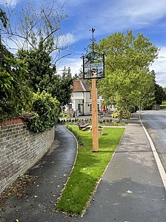
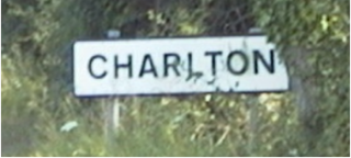
Charlton is a hamlet in the county of Hertfordshire, in the East of England. It is a component hamlet of the market town of Hitchin, forming a part of the Hitchin Priory ward. Its rural character is protected as a Conservation Area. Situated east of the Chilterns AONB, it lies 30 miles north of London.

Baunton is a village and civil parish in the Cotswold district of Gloucestershire, England, located about two miles north of Cirencester on the River Churn.

Kinwarton is a village in the valley of the River Alne, Warwickshire, to the north-east of the market town of Alcester. The population of the civil parish at the 2011 Census was 1,082. The ground is mostly low-lying, with a maximum altitude of 206 ft. and some of the fields near the river are liable to floods. The road from Alcester to Henley-in-Arden runs through the middle of the parish. A branch road leads off to the church and rectory about a quarter of a mile to the south and thence continues as a field-path down to a ford across the River Alne below Hoo Mill. From the north side of the main road a by-road branches off to Coughton.

Temple Grafton is a village and civil parish in the Stratford district of Warwickshire, England, situated about 4 miles (6.4 km) east of Alcester and 14 miles (23 km) west of the county town of Warwick. The place name is misleading, the Knights Templar never having any association with the place but owing to a naming error made in the time of Henry VIII the mistake has been perpetuated. During the reign of Richard I the estate in fact belonged to the Knights Hospitaller. During the reign of Edward III in 1347 the village was recorded as Grafton Superior while neighbouring Ardens Grafton was named Inferior

North Hertfordshire was a parliamentary constituency in Hertfordshire. It returned one Member of Parliament (MP) to the House of Commons of the Parliament of the United Kingdom by the first-past-the-post system.
King's Walden is a civil parish in the English county of Hertfordshire. The name includes an apostrophe, but this is often omitted.

Biscot is an area of Luton close to the town centre, in the Luton district, in the ceremonial county of Bedfordshire, England. The area is roughly bounded by Montrose Avenue to the north, the Midland Main Line to the west, and the A6 to the east.
Hertingfordbury is a small village in Hertfordshire, England, close to the county town of Hertford. It was mentioned in the Domesday Book. Hertingfordbury is also the name of a neighbouring civil parish, which does not contain the village, which is actually within the local government area of Hertford Town Council. The population of the civil parish as of the 2011 census was 630.

Wymondley is a civil parish in Hertfordshire, England.
Langley is a hamlet and civil parish in the non-metropolitan district of North Hertfordshire and county of Hertfordshire. The population was 175 in the 2011 census. It is located four miles south of Hitchin, on the B656 road near the large town of Stevenage. Minsden Chapel lies within the parish.

Preston Bagot is a village and civil parish in the Stratford district of Warwickshire, England, about 6 miles (9.7 km) west of the county town of Warwick. According to the 2001 census the population was 147, reducing to 127 at the 2011 census.
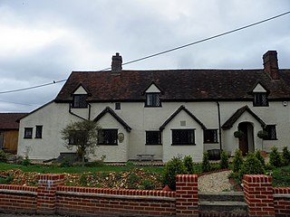
Charlton Manor is an English manor and ancient demesne over 1,000 years old in the county of Hertfordshire in England, approximately 45 minutes north of London, and adjacent to the market town of Hitchin with which it has ancient historical connections. Charlton Manor is recorded in the Hertfordshire County Archives.

