Brighton Beach station (BMT Brighton Line)

Last updated

 Brighton Beach
  NYCS-bull-trans-B-Std.svg NYCS-bull-trans-Q-Std.svg
MTA NYC logo.svg New York City Subway station (rapid transit)
Brighton Beach - Coney Island Bound Platform.jpg
Southbound platform, with a museum train of D-type Triplexes on the left
Station statistics
AddressBrighton Sixth Street & Brighton Beach Avenue
Brooklyn, NY 11235
Borough Brooklyn
Locale Brighton Beach
Coordinates 40°34′39″N73°57′42″W / 40.577598°N 73.961565°W / 40.577598; -73.961565
Division B (BMT) [1]
Line BMT Brighton Line
Services    B   NYCS-SSI-weekdaysonly.svg (weekday rush hours, middays and early evenings)
   Q   NYCS-SSI-alltimes.svg (all times)
TransitAiga bus trans.svg NYCT Bus: B1, B68
Structure Elevated
Platforms2 island platforms
cross-platform interchange
Tracks4
Other information
Openedoriginal station: July 2, 1878;145 years ago (1878-07-02)
Rebuiltcurrent station: 1907;117 years ago (1907)
Opposite-
direction
transfer
Yes
Traffic
20232,635,382 [2] Increase2.svg 15.4%
Rank132 out of 423 [2]
Services
Preceding station MTA NYC logo.svg New York City Subway Following station
Sheepshead Bay
B   NYCS-SSI-weekdaysonly.svg Q   NYCS-SSI-alltimes.svg
northbound
NYCS-bull-trans-B-Std.svg
Express
Terminus
NYCS-bull-trans-Q-Std.svg
Local
Ocean Parkway
Q   NYCS-SSI-alltimes.svg
Location
NYCS map blank.svg
Map pointer.svg
USA New York City location map.svg
Map pointer.svg
USA New York location map.svg
Map pointer.svg
Track layout

Contents

BSicon MFADEg.svg
BSicon uvSTR.svg
BSicon MFADEg.svg
BSicon uvSTR.svg
BSicon uvSTRf.svg
BSicon uvSTRg.svg
BSicon numN285.svg
BSicon uvUST.svg
BSicon uvUST.svg
BSicon uv-SHI2r.svg
BSicon uvUST.svg
BSicon uvSHI2l-.svg
BSicon udSTR.svg
BSicon dPLT.svg
BSicon uvSTR.svg
BSicon dPLT.svg
BSicon udSTR.svg
BSicon udSTR.svg
BSicon dPLT.svg
BSicon uvSTR.svg
BSicon dPLT.svg
BSicon udSTR.svg
BSicon udSTR.svg
BSicon dPLT.svg
BSicon uvSTR.svg
BSicon dPLT.svg
BSicon udSTR.svg
BSicon udSTR.svg
BSicon dPLT.svg
BSicon uvSTR.svg
BSicon dPLT.svg
BSicon udSTR.svg
BSicon udSHI2gl.svg
BSicon udSHI2+lr.svg
BSicon udSHI2gr.svg
BSicon udSHI2gl.svg
BSicon udSHI2+lr.svg
BSicon udSHI2gr.svg
BSicon uvSTR.svg
BSicon uvUST.svg
BSicon uvSTR.svg
BSicon uvSTR.svg
BSicon uvSTR.svg
BSicon uvSTR.svg
BSicon uvSTR.svg
BSicon uvSTR.svg
BSicon uvSTR.svg
BSicon uvSTR.svg
BSicon uvSTR.svg
BSicon uvSTR.svg
BSicon udSTRf.svg
BSicon udENDEe.svg
BSicon uvSTR.svg
BSicon udENDEe.svg
BSicon udSTRg.svg
layup tracks
BSicon dMFADEf.svg
BSicon uvSTR-.svg
BSicon MFADEf.svg
BSicon uvSTR.svg
BSicon MFADEf.svg
BSicon uv-STR.svg
Street map

Brighton Beach station (BMT Brighton Line)

Station service legend
SymbolDescription
NYCS-SSI-alltimes.svg Stops all times
NYCS-SSI-weekdaysonly.svg Stops weekdays during the day

The Brighton Beach station is an elevated express and terminal station on the BMT Brighton Line of the New York City Subway. It is located over Brighton Beach Avenue between Brighton 5th Street and Brighton 7th Street in Brighton Beach, Brooklyn. The station is served by the Q train at all times and is the southern terminal for the B train on weekdays only.

History

This station opened on July 2, 1878, as part of an excursion railroad—the Brooklyn, Flatbush and Coney Island Railway—to bring beachgoers from downtown Brooklyn (via a connection with the Long Island Rail Road) to the seashore at Coney Island on the Atlantic Ocean, at a location named Brighton Beach at the same time the railroad arrived.

During the 1964–1965 fiscal year, work was underway to lengthen the platforms to 615 feet (187 m) to accommodate a ten-car train of 60 feet (18 m)-long IND cars, or a nine-car train of 67 feet (20 m)-long BMT cars. [3]

The station was renovated during the 1990s. [4]

From September 8, 2002, to May 23, 2004, service was suspended west of Brighton Beach to allow rebuilding of the Coney Island–Stillwell Avenue terminal station, which had deteriorated due to the effects of salt water corrosion and deferred maintenance. [5]

Station layout

Platform
level
Northbound local NYCS-bull-trans-Q-Std.svg toward 96th Street (Sheepshead Bay)
Island platform
Northbound express NYCS-bull-trans-B-Std.svg weekdays toward Bedford Park Boulevard or 145th Street (Sheepshead Bay)
Northbound express NYCS-bull-trans-B-Std.svg Weekdays toward Bedford Park Boulevard or 145th Street (Sheepshead Bay)
Island platform
Southbound local NYCS-bull-trans-Q-Std.svg toward Coney Island–Stillwell Avenue (Ocean Parkway)
Mezzanine'Fare control, station agent, MetroCard machines
GroundStreet levelEntrances/exits

Brighton Beach has two island platforms and four tracks. [6] The weekday-only B train (Brighton Express/Sixth Avenue Express) originates and terminates here on the inner express tracks while the full-time Q train (Brighton Local/Broadway Express) stops here on the outer local tracks, and continues to and from Coney Island–Stillwell Avenue. The next stop to the west (railroad south) is Ocean Parkway for Q trains, while the next stop to the east (railroad north) is Sheepshead Bay for all service. [7]

Between this station and Ocean Parkway, the line becomes six tracks. The local and express tracks split into an extra storage track in-between them in both directions. These tracks are commonly used for storing B trains during midday hours or at the start or end of service, and they end at bumper blocks next to the platforms at Ocean Parkway. [6] East of this station, there are diamond crossovers used by originating and terminating B trains. The Brighton Line curves north and becomes an embankment after crossing Neptune Avenue on the approach to Sheepshead Bay. [6]

The platforms are canopied for their entire length except for small portions at either ends. There are two elevated structures above the express tracks used for office and maintenance space.

This station has two entrances/exits, both of which are elevated station houses beneath the tracks. The full-time side is at the north end and has two staircases from each platform, a large waiting area inside fare control, regular turnstile bank, and token booth. Outside of fare control, there are three street stairs, two that join at the station house balcony and go down to either southern corners of Brighton 7th Street and Brighton Beach Avenue and one to the northwest corner. Instead of a staircase, the northeast corner has a narrow, enclosed escalator that always goes up and thus can only be used to enter the station.

The second station house has a single staircase from each platform and a pair of twin staircases going down to either side of Brighton Beach Avenue between Brighton Fifth and Brighton Sixth Streets. The token booth and regular turnstile bank here is only open weekdays from 6:00 a.m. to 9:00 p.m. Two HEET turnstiles provide access to/from this entrance at other times.

This station was renovated in the mid to late 1990s and included installation of decorative awnings on all street stairs. The 1999 artwork here is called Mermaid/Dionysus and the Pirates by Dan George and features aluminum sculptures on both platforms. [8]

Exits

The station has two mezzanines under the platforms and tracks, each of which has four sets of stairs to the street and one to each platform. The eastern, and staffed entrances are located between Brighton 7th Street and Coney Island Avenue. There is an up-only escalator in place of one of the stairs on the northern side of Brighton Beach Avenue at Coney Island Avenue. The western exit, which is unstaffed, is located between Brighton 5th and 6th Streets. [9]

Related Research Articles

<span class="mw-page-title-main">New York City Subway stations</span> Rapid transit system in New York City

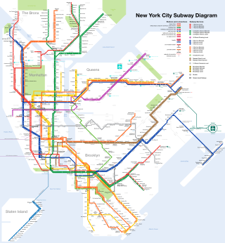
The New York City Subway is a rapid transit system that serves four of the five boroughs of New York City, New York: the Bronx, Brooklyn, Manhattan, and Queens. Its operator is the New York City Transit Authority, which is itself controlled by the Metropolitan Transportation Authority of New York. In 2015, an average of 5.65 million passengers used the system daily, making it the busiest rapid transit system in the United States and the 11th busiest in the world.

<span class="mw-page-title-main">Ocean Parkway station</span> New York City Subway station in Brooklyn

The Ocean Parkway station is an express station on the New York City Subway's BMT Brighton Line. It is located at Brighton Beach Avenue and Ocean Parkway in Brighton Beach, Brooklyn. The station is served by the Q train at all times.

<span class="mw-page-title-main">Coney Island–Stillwell Avenue station</span> New York City Subway station in Brooklyn

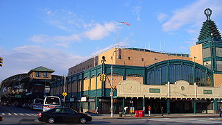
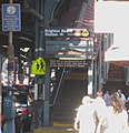
The Coney Island–Stillwell Avenue station is a New York City Subway terminal in Coney Island, Brooklyn. It is the railroad-south terminus for the D, F, N, and Q trains at all times and for the <F> train during rush hours in the peak direction.

The BMT Sea Beach Line is a rapid transit line of the BMT division of the New York City Subway, connecting the BMT Fourth Avenue Line at 59th Street via a four-track wide open cut to Coney Island in Brooklyn. It has at times hosted the fastest express service between Manhattan and Coney Island, since there are no express stations along the entire stretch, but now carries only local trains on the N service, which serves the entire line at all times. During rush hours, several W trains serve the line north of 86th Street.

<span class="mw-page-title-main">34th Street–Herald Square station</span> New York City Subway station in Manhattan

The 34th Street–Herald Square station is an underground station complex on the BMT Broadway Line and the IND Sixth Avenue Line of the New York City Subway. It is located at Herald Square in Midtown Manhattan where 34th Street, Broadway and Sixth Avenue intersect, and is served by the D, F, N, and Q trains at all times; the R train at all times except late nights; the B, M, and W trains on weekdays; and the <F> train during rush hours in the peak direction.

<span class="mw-page-title-main">Prospect Park station (BMT lines)</span> New York City Subway station in Brooklyn

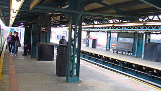
The Prospect Park station is an express station on the BMT Brighton Line of the New York City Subway. It is located in between Lincoln Road, Lefferts Avenue, Empire Boulevard, Ocean Avenue and Flatbush Avenue in Flatbush, Brooklyn, near the border of Crown Heights, Prospect Heights, Park Slope, and Prospect Lefferts Gardens. The station, which serves Prospect Park and Brooklyn Botanic Garden, is served by the Q train and Franklin Avenue Shuttle at all times and by the B train on weekdays.

<span class="mw-page-title-main">Seventh Avenue station (IND Culver Line)</span> New York City Subway station in Brooklyn

The Seventh Avenue station is an express station on the IND Culver Line of the New York City Subway, located at Seventh Avenue and Ninth Street in the Park Slope neighborhood of Brooklyn. It is served by the F and G trains at all times, and by the <F> train during rush hours in the peak direction.

<span class="mw-page-title-main">Avenue J station</span> New York City Subway station in Brooklyn

The Avenue J station is a local station on the BMT Brighton Line of the New York City Subway, located on Avenue J between East 15th and East 16th Streets in Midwood, Brooklyn. The station is served by the Q train at all times.

<span class="mw-page-title-main">Sheepshead Bay station</span> New York City Subway station in Brooklyn

The Sheepshead Bay station is an express station on the BMT Brighton Line of the New York City Subway. It is located in the Sheepshead Bay neighborhood of Brooklyn. It is served by the Q train at all times and by the B train on weekdays.

<span class="mw-page-title-main">West Eighth Street–New York Aquarium station</span> New York City Subway station in Brooklyn

The West Eighth Street–New York Aquarium station is a New York City Subway station, located on the BMT Brighton Line and IND Culver Line in the Coney Island neighborhood of Brooklyn. The station is located over the private right-of-way of the defunct New York and Coney Island Railroad north of Surf Avenue, running easterly from West 8th Street. It is served by the F and Q trains at all times, and by the <F> train during rush hours in the peak direction. This station is geographically the southernmost station in the entire New York City Subway system.

<span class="mw-page-title-main">Avenue M station</span> New York City Subway station in Brooklyn

The Avenue M station, is a local station on the BMT Brighton Line of the New York City Subway. It is located in Midwood, Brooklyn, at Avenue M between East 15th and East 16th Streets. The station is served by the Q train at all times.

<span class="mw-page-title-main">Neck Road station</span> New York City Subway station in Brooklyn

The Neck Road station is a local station on the BMT Brighton Line of the New York City Subway. It is located at Gravesend Neck Road between East 15th and East 16th Streets in Homecrest, Brooklyn. The station is served by the Q train at all times.

<span class="mw-page-title-main">Avenue U station (BMT Brighton Line)</span> New York City Subway station in Brooklyn

The Avenue U station is a local station on the BMT Brighton Line of the New York City Subway, located at Avenue U between East 15th and East 16th Streets in Homecrest and Sheepshead Bay, Brooklyn. The station is served by the Q train at all times.

<span class="mw-page-title-main">Kings Highway station (BMT Brighton Line)</span> New York City Subway station in Brooklyn

The Kings Highway station is an express station on the BMT Brighton Line of the New York City Subway. It is located at Kings Highway between East 15th and East 16th Streets on the border of Midwood and Sheepshead Bay neighborhoods of Brooklyn. The station is served by the Q train at all times and by the B train on weekdays only.

<span class="mw-page-title-main">Avenue U station (IND Culver Line)</span> New York City Subway station in Brooklyn

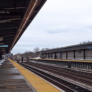
The Avenue U station is a local station on the IND Culver Line of the New York City Subway, located at the intersection of Avenue U and McDonald Avenue in Gravesend, Brooklyn. It is served by the F train at all times and the <F> train during rush hours in the peak direction.

<span class="mw-page-title-main">Avenue X station</span> New York City Subway station in Brooklyn

The Avenue X station is a local station in the Gravesend neighborhood of Brooklyn on the IND Culver Line of the New York City Subway. It is served by the F train at all times and the <F> train during rush hours in the peak direction.

<span class="mw-page-title-main">Neptune Avenue station</span> New York City Subway station in Brooklyn

The Neptune Avenue station is a station on the IND Culver Line of the New York City Subway, located in Coney Island, Brooklyn, at the intersection of Neptune Avenue and West 6th Street. It is served by the F train at all times and the <F> train during rush hours in the peak direction.

<span class="mw-page-title-main">55th Street station</span> New York City Subway station in Brooklyn

The 55th Street station is a local station on the BMT West End Line of the New York City Subway, located at the intersection of 55th Street and 13th Avenue in Borough Park, Brooklyn. It is served by the D train at all times. The station opened in 1916, and had its platforms extended in the 1960s.

<span class="mw-page-title-main">Bay Parkway station (BMT West End Line)</span> New York City Subway station in Brooklyn

The Bay Parkway station is an express station on the BMT West End Line of the New York City Subway, located in Bensonhurst, Brooklyn at the intersection of Bay Parkway and 86th Street. The station is served by the D train at all times.

<span class="mw-page-title-main">25th Avenue station</span> New York City Subway station in Brooklyn

The 25th Avenue station is a local station on the BMT West End Line of the New York City Subway, located in Brooklyn at the intersection of 25th Avenue and 86th Street, on the border of the Bensonhurst, Bath Beach, and Gravesend neighborhoods of Brooklyn. This station is served by the D train at all times.

References

  1. "Glossary". Second Avenue Subway Supplemental Draft Environmental Impact Statement (SDEIS) (PDF). Vol. 1. Metropolitan Transportation Authority. March 4, 2003. pp. 1–2. Archived from the original (PDF) on February 26, 2021. Retrieved January 1, 2021.
  2. 1 2 "Annual Subway Ridership (2018–2023)". Metropolitan Transportation Authority. 2023. Retrieved April 20, 2024.
  3. Annual Report 1964–1965. New York City Transit Authority. 1965.
  4. "TA's rehab program in state of disrepair". New York Daily News. April 1, 1996. p. 22 via Newspapers.com.
  5. "Stillwell Terminal Remains a Sparkling Jewel a Decade after Full Rehabilitation". mta.info. Metropolitan Transportation Authority. May 20, 2014. Archived from the original on December 1, 2021. Retrieved August 15, 2016.
  6. 1 2 3 Dougherty, Peter (2006) [2002]. Tracks of the New York City Subway 2006 (3rd ed.). Dougherty. OCLC   49777633 via Google Books.
  7. "Subway Map" (PDF). Metropolitan Transportation Authority. September 2021. Retrieved September 17, 2021.
  8. Bloodworth, Sandra (2014). New York's Underground Art Museum: MTA Arts and Design. Monacelli Press. p. 210. ISBN   978-1-58093-403-9.
  9. "Brighton Beach Neighborhood Map". mta.info. Metropolitan Transportation Authority. April 2018. Retrieved May 20, 2022.