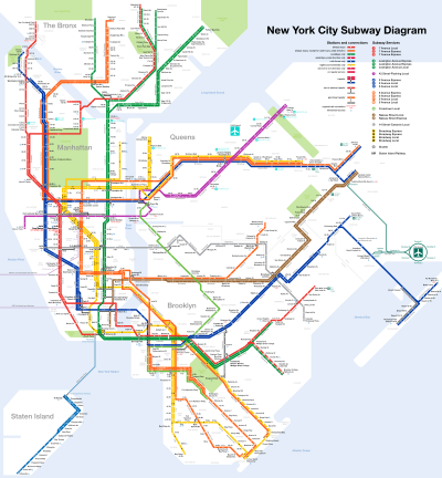
List of New York City Subway stations in Brooklyn

Last updated

The current New York City Transit Authority rail system map; Brooklyn is located on the bottom-center portion of the map. NYC subway-4D.svg
The current New York City Transit Authority rail system map; Brooklyn is located on the bottom-center portion of the map.

The New York City Subway is a rapid transit system that serves four of the five boroughs of New York City in the U.S. state of New York: the Bronx, Brooklyn, Manhattan, and Queens. Operated by the New York City Transit Authority under the Metropolitan Transportation Authority of New York, the New York City Subway is the busiest rapid transit system in the United States and the seventh busiest in the world, with 5.225 million daily riders. The system's 472 stations qualifies it to have the largest number of rapid transit stations in the world.

Contents

Three rapid transit companies merged in 1940 to create the present New York City Subway system: the Interborough Rapid Transit Company (IRT), the Brooklyn–Manhattan Transit Corporation (BMT), and the Independent Subway System (IND). All three former systems are present in Brooklyn.

History

The vast majority of current subway lines in Brooklyn trace their lineage back to the Brooklyn–Manhattan Transit (BMT) and Brooklyn Rapid Transit (BRT), as well as earlier predecessors. The oldest right-of-way in the entire subway system is that of the West End Line. Its right-of-way began passenger service on October 9, 1863, as a surface steam railroad called the Brooklyn, Bath and Coney Island. [1] [2] It was later rebuilt under the Dual Contracts, opening as the current elevated road on June 24, 1916. [3] The West End line is not the oldest elevated in Brooklyn. That honor goes to the BMT Jamaica Line with the section from Gates Avenue to Van Siclen Avenue to an opening on May 13, 1885. [4] The oldest un-rebuilt section still in use, is from Alabama Avenue to Cypress Hills. That section opened between September 5, 1885, and May 30, 1893. [5] [6] Both segments were originally part of the demolished BMT Lexington Avenue Line. The rest of the line from Marcy Avenue to Broadway Junction was rebuilt during the Dual Contracts. It was also extended past Cypress Hills towards Jamaica, Queens during that time.

Similar histories to the BMT West End Line can be found with the BMT Sea Beach Line (New York and Sea Beach Railroad), and BMT Culver Line (Prospect Park and Coney Island Railroad). Other truncated lines dating back to the same period as the Jamaica and Lexington Els are the Myrtle Avenue and BMT Fulton Street Lines.

Both the BMT Franklin Avenue Line and BMT Brighton Line began as another excursion railroad to Coney Island called the Brooklyn, Flatbush and Coney Island Railway. Originating on July 2, 1878, the BF&CI ran from the former Bedford Station on the Atlantic Branch of the Long Island Rail Road, to Brighton Beach. It also had a spur to the Sheepshead Bay Race Track southeast of Neck Road. Losing their connection to the LIRR in 1893, the railroad almost collapsed until it was acquired by the Kings County Elevated Railway in 1896, which electrified the line by 1899 for both rapid transit and streetcar lines, and itself became part of Brooklyn Rapid Transit in 1900. Grade elimination projects took place during the mid-1900s and late-1910s. A subway connection between Prospect Park and DeKalb Avenue on the BMT Fourth Avenue Line was completed by 1920.

The BMT Canarsie Line began on October 21, 1865, as the Brooklyn and Rockaway Beach Railroad, a surface steam excursion railroad line for beachgoers. Once acquired by the BRT in 1906, it was split between a mostly elevated rapid transit line from Rockaway Boulevard and Broadway Junction, and the Canarsie Shuttle streetcar line south of Rockaway Boulevard to Jamaica Bay by 1920. A subway extension to Manhattan from Broadway Junction known as the "14th Street–Eastern District Line" was built in 1928. The Liberty Avenue extension of the Fulton Street Elevated opened on September 25, 1915, and the extension of the Jamaica Avenue Elevated to Walnut Street opened on May 28, 1917. A further extension of the latter line opened to Cliffside Avenue on July 2, 1918. [7]

Also on June 22, 1915, the BRT opened the Fourth Avenue Subway from Myrtle Avenue to 59th Street as well as the BMT Sea Beach Line, which provided service to Coney Island. The Fourth Avenue Line was then extended the line south to 86th Street in Bay Ridge on January 15, 1916. The West End Line opened in stages. The line opened from Ninth Avenue to 18th Avenue on June 24, 1916, to 25th Avenue on July 29, 1916, and to Coney Island on July 21, 1917. Culver Line service was inaugurated on March 16, 1919, to Kings Highway. Service was extended to Avenue X on May 10, 1919, before running through to Coney Island on May 1, 1920. The Montague Street Tunnel opened on August 1, 1920, connecting Brooklyn directly to Lower Manhattan. On the same date, the connection between the Brighton Line connection between Prospect Park and DeKalb Avenue was opened. [7] Two additional stations along the Fourth Avenue Line were opened at a later date by the BMT. An in-fill station, Lawrence Street, was opened in Downtown Brooklyn on June 11, 1924, and the line was extended to its new terminal at 95th Street in Fort Hamilton on October 31, 1925. The Fourth Avenue Line would replace the elevated BMT Fifth Avenue Line on June 1, 1940, and inherited the connections to the West End and Sea Beach Lines. The Myrtle Avenue station was closed in 1956 as part of the reconstruction of the DeKalb Avenue junction.

Besides the BMT and its predecessors, the Interborough Rapid Transit Company expanded two subways and one elevated line into Brooklyn. The Eastern Parkway Line was built under Brooklyn Borough Hall to Atlantic Avenue in 1908 and then to Utica Avenue in Crown Heights in 1920. This line is fed from Manhattan by the IRT Lexington Avenue Line via the Joralemon Street Tunnel as well as the Brooklyn Branch of the IRT Broadway–Seventh Avenue Line through the Clark Street Tunnel. Additionally, two extensions from the Eastern Parkway Line was built in 1920. The first being the Nostrand Avenue Line from the Brooklyn Botanic Garden to Flatbush Avenue in Flatbush. The second was the elevated New Lots Line, over East 98th Street and Livonia Avenue in Brownsville and East New York to Pennsylvania Avenue, and was expanded to New Lots Avenue in 1922. [7]

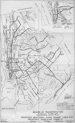
In 1933, the city-owned Independent Subway System built the IND Crosstown Line from Court Square in Long Island City south to Nassau Avenue in Greenpoint, and then from Metropolitan Avenue in Williamsburg to Hoyt and Schermerhorn Streets in Downtown Brooklyn. Additionally, in 1933, they built IND Brooklyn Line from Jay Street–Borough Hall to Church Avenue station. Three years later, the IND Sixth Avenue Line was connected to Jay Street through the Rutgers Street Tunnel. The connecting ramps between Church Avenue and Ditmas Avenue on the BMT Culver Line did not exist until 1954, and once they did, the Culver Line was "recaptured" by the IND, with them except for the Culver Shuttle northwest to Ninth Avenue on the BMT West End Line. This segment of the BMT Culver Line was abandoned on May 10, 1975. The newest line in Brooklyn is the ramp from the IND Fulton Street Subway connecting with the former BMT Fulton Street elevated which opened on April 29, 1956. This ramp includes a connection to Pitkin Yard and the Grant Avenue station.

Description

There are 170 New York City Subway stations in Brooklyn (171 if 75th Street–Elderts Lane, which is located in both Brooklyn and Queens, is included). [^ 1] When transfer stations with two or more non-adjacent platforms are counted as one station, the number of stations is 157. The physical trackage lines within Brooklyn include:

Lines and services

There are 170 New York City Subway stations in Brooklyn, per the official count of the Metropolitan Transportation Authority; of these, 22 are express-local stations. If the 10 station complexes are counted as one station each, the number of stations is 157. In the table below, lines with colors next to them indicate trunk lines, which determine the colors that are used for services' route bullets and diamonds. The opening date refers to the opening of the first section of track for the line. In the "division" column, the current division is followed by the original division in parentheses.

DivisionLineServicesStations in BrooklynOpenedContinues to
B (BMT)16 (3 express-local stations, 4 part of station complexes, 1 shared with Brighton Line)June 22, 1915 Manhattan
B (IND)  Sixth Avenue Line April 9, 1936 Manhattan
B (IND)  Eighth Avenue Line February 1, 1933 Manhattan
B (BMT) Brighton Line 20 (6 express-local stations (1 shared with Franklin Avenue Line), 1 part of a station complex, 1 shared with Fourth Avenue Line, 1 shared with Culver Line, 1 shared with Culver, Sea Beach, and West End Lines)July 2, 1878 Manhattan
A (IRT)  Broadway–Seventh Avenue Line April 15, 1919 Manhattan
B (BMT)  Canarsie Line 19 (3 part of station complexes)July 28, 1906 Manhattan
B (IND)  Crosstown Line 11 (1 part of a station complex, 1 shared with Fulton Street Line)August 19, 1933 Queens
B (IND) Culver Line 21 (2 part of station complexes, 1 shared with Fulton Street Line, 1 shared with Brighton Line, 1 shared with Brighton, Sea Beach & West End Lines)March 16, 1919
A (IRT) Eastern Parkway Line 11 (4 express-local stations, 3 part of station complexes)January 9, 1908 Manhattan
B (BMT) Franklin Avenue Line August 18, 1878
B (IND) Fulton Street Line 16 (5 express-local stations, 3 part of station complexes, 1 shared with Culver Line, 1 shared with Crosstown Line)April 9, 1936 Queens
B (BMT) Jamaica Line 16 (4 express-local stations, [^ 2] 1 part of a station complex)June 25, 1888 Manhattan, Queens
B (BMT) Myrtle Avenue Line April 10, 1888 Queens
A (IRT) New Lots Line November 22, 1920
A (IRT) Nostrand Avenue Line August 23, 1920
B (BMT) Sea Beach Line 10 (1 part of a station complex, 1 shared with Brighton, Culver & West End Lines)June 22, 1915
B (BMT) West End Line 13 (1 part of a station complex, 1 shared with Brighton, Culver & Sea Beach Lines)June 24, 1916

Stations

Permanently closed subway stations, including those that have been demolished, are not included in the list below. The 95th Street station is listed under "Bay Ridge–95th Street."

Station service legend
NYCS-SSI-alltimes.svg Stops all times
NYCS-SSI-allexceptnights.svg Stops all times except late nights
NYCS-SSI-nightsonly.svg Stops late nights only
NYCS-SSI-weekdaysonly.svg Stops weekdays during the day
NYCS-SSI-allexceptrush.svg Stops all times except rush hours in the peak direction
NYCS-SSI-allexceptrush.svg Stops all times except nights and rush hours in the peak direction
NYCS-SSI-rushonly.svg Stops rush hours only
NYCS-SSI-rushpeak.svg Stops rush hours in the peak direction only
Time period details
Wheelchair symbol.svg Station is compliant with the Americans with Disabilities Act
Wheelchair symbol.svg  Station is compliant with the Americans with Disabilities Act
in the indicated direction only
Wheelchair symbol.svg  
Aiga elevator.svg Elevator access to mezzanine only
*Station is part of a station complex
**Transfer stations either between local and express services or that involve the terminus of a service on the same line; may also be part of a station complex as defined above
***Multi-level or adjacent-platform transfer stations on different lines considered to be one station as classified by the MTA
Terminal of a service
*†, **† or ***†Transfer stations and terminals
Last station in Brooklyn before service continues to Manhattan or Queens
*‡, **‡, or ***‡Last station in Brooklyn and a transfer station
*†‡, **†‡, or ***†‡Last station in Brooklyn, a transfer station and a terminal
Station Wheelchair symbol.svg DivisionLineServicesOpened [8] [9] [10]
004Fourth Avenue* [^ 4] 2 B (IND) Culver Line    F   NYCS-SSI-alltimes.svg
   G   NYCS-SSI-alltimes.svg
October 7, 1933 [10]
007Seventh Avenue 2 B (BMT) Brighton Line    B   NYCS-SSI-weekdaysonly.svg
   Q   NYCS-SSI-alltimes.svg
August 1, 1920 [9]
007Seventh Avenue 0 Wheelchair symbol.svg B (IND) Culver Line    F   NYCS-SSI-alltimes.svg <F> NYCS-SSI-rushpeak.svg
   G   NYCS-SSI-alltimes.svg
October 7, 1933 [10]
008Eighth Avenue 0 Wheelchair symbol.svg B (BMT) Sea Beach Line    N   NYCS-SSI-alltimes.svg
   W   NYCS-SSI-rushonly.svg
June 22, 1915 [9]
009Ninth Avenue 2 B (BMT) West End Line    D   NYCS-SSI-alltimes.svg June 24, 1916 [9]
009Ninth Street* [^ 4] 2 B (BMT) Fourth Avenue Line    D   NYCS-SSI-nightsonly.svg
   N   NYCS-SSI-nightsonly.svg
   R   NYCS-SSI-alltimes.svg
   W   NYCS-SSI-rushonly.svg
June 22, 1915 [9]
015th Street–Prospect Park 2 B (IND) Culver Line    F   NYCS-SSI-alltimes.svg
   G   NYCS-SSI-alltimes.svg
October 7, 1933 [10]
018th Avenue 2 B (IND) Culver Line    F   NYCS-SSI-alltimes.svg <F> NYCS-SSI-rushpeak.svg March 16, 1919 [10]
018th Avenue 2 B (BMT) Sea Beach Line    N   NYCS-SSI-alltimes.svg
   W   NYCS-SSI-rushonly.svg
June 22, 1915 [9]
018th Avenue 2 B (BMT) West End Line    D   NYCS-SSI-alltimes.svg June 24, 1916 [9]
020th Avenue 2 B (BMT) Sea Beach Line    N   NYCS-SSI-alltimes.svg
   W   NYCS-SSI-rushonly.svg
June 22, 1915 [9]
020th Avenue 2 B (BMT) West End Line    D   NYCS-SSI-alltimes.svg July 29, 1916 [11]
025th Avenue 2 B (BMT) West End Line    D   NYCS-SSI-alltimes.svg July 29, 1916 [11]
025th Street 2 B (BMT) Fourth Avenue Line    D   NYCS-SSI-nightsonly.svg
   N   NYCS-SSI-nightsonly.svg
   R   NYCS-SSI-alltimes.svg
   W   NYCS-SSI-rushonly.svg
June 22, 1915 [9]
036th Street**2 B (BMT) Fourth Avenue Line    D   NYCS-SSI-alltimes.svg
   N   NYCS-SSI-alltimes.svg
   R   NYCS-SSI-alltimes.svg
   W   NYCS-SSI-rushonly.svg
June 22, 1915 [9]
045th Street 2 B (BMT) Fourth Avenue Line    N   NYCS-SSI-nightsonly.svg
   R   NYCS-SSI-alltimes.svg
   W   NYCS-SSI-rushonly.svg
September 22, 1915 [12]
050th Street 2 B (BMT) West End Line    D   NYCS-SSI-alltimes.svg June 24, 1916 [9]
053rd Street 2 B (BMT) Fourth Avenue Line    N   NYCS-SSI-nightsonly.svg
   R   NYCS-SSI-alltimes.svg
   W   NYCS-SSI-rushonly.svg
September 22, 1915 [12]
055th Street 2 B (BMT) West End Line    D   NYCS-SSI-alltimes.svg June 24, 1916 [9]
059th Street**0 Wheelchair symbol.svg B (BMT) Fourth Avenue Line    N   NYCS-SSI-alltimes.svg
   R   NYCS-SSI-alltimes.svg
   W   NYCS-SSI-rushonly.svg
June 22, 1915 [9]
062nd Street* [^ 5] 0 Wheelchair symbol.svg B (BMT) West End Line    D   NYCS-SSI-alltimes.svg June 24, 1916 [9]
071st Street 2 B (BMT) West End Line    D   NYCS-SSI-alltimes.svg June 24, 1916 [9]
077th Street 2 B (BMT) Fourth Avenue Line    R   NYCS-SSI-alltimes.svg January 15, 1916 [9]
079th Street 2 B (BMT) West End Line    D   NYCS-SSI-alltimes.svg June 24, 1916 [9]
086th Street 0 Wheelchair symbol.svg B (BMT) Fourth Avenue Line    R   NYCS-SSI-alltimes.svg January 15, 1916 [9]
086th Street 2 B (BMT) Sea Beach Line    N   NYCS-SSI-alltimes.svg
   W   NYCS-SSI-rushonly.svg
June 22, 1915 [9]
Alabama Avenue 2 B (BMT) Jamaica Line    J   NYCS-SSI-alltimes.svg
   Z   NYCS-SSI-rushpeak.svg
December 21, 1916 [9]
Atlantic Avenue 2 B (BMT) Canarsie Line    L   NYCS-SSI-alltimes.svg July 28, 1906 [13]
Atlantic Avenue–Barclays Center* [^ 6] 0 Wheelchair symbol.svg B (BMT) Brighton Line    B   NYCS-SSI-weekdaysonly.svg
   Q   NYCS-SSI-alltimes.svg
August 1, 1920 [9]
Atlantic Avenue–Barclays Center** [^ 6] [^ 7] 0 Wheelchair symbol.svg A (IRT) Eastern Parkway Line    2   NYCS-SSI-alltimes.svg
   3   NYCS-SSI-allexceptnights.svg
   4   NYCS-SSI-alltimes.svg
   5   NYCS-SSI-weekdaysonly.svg
May 1, 1908 [8]
Atlantic Avenue–Barclays Center**‡ [^ 6] 0 Wheelchair symbol.svg B (BMT) Fourth Avenue Line    D   NYCS-SSI-alltimes.svg
   N   NYCS-SSI-alltimes.svg
   R   NYCS-SSI-alltimes.svg
   W   NYCS-SSI-rushonly.svg
June 22, 1915 [9]
Avenue H 0 Wheelchair symbol.svg B (BMT) Brighton Line    Q   NYCS-SSI-alltimes.svg 1907 [9]
Avenue I 2 B (IND) Culver Line    F   NYCS-SSI-alltimes.svg <F> NYCS-SSI-rushpeak.svg March 16, 1919 [10]
Avenue J 2 B (BMT) Brighton Line    Q   NYCS-SSI-alltimes.svg 1907 [9]
Avenue M 2 B (BMT) Brighton Line    Q   NYCS-SSI-alltimes.svg 1907 [9]
Avenue N 2 B (IND) Culver Line    F   NYCS-SSI-alltimes.svg <F> NYCS-SSI-rushpeak.svg March 16, 1919 [10]
Avenue P 2 B (IND) Culver Line    F   NYCS-SSI-alltimes.svg <F> NYCS-SSI-rushpeak.svg March 16, 1919 [10]
Avenue U 2 B (BMT) Brighton Line    Q   NYCS-SSI-alltimes.svg 1907 [9]
Avenue U 2 B (IND) Culver Line    F   NYCS-SSI-alltimes.svg <F> NYCS-SSI-rushpeak.svg May 10, 1919 [10]
Avenue U 2 B (BMT) Sea Beach Line    N   NYCS-SSI-alltimes.svg
   W   NYCS-SSI-rushonly.svg
June 22, 1915 [9]
Avenue X 2 B (IND) Culver Line    F   NYCS-SSI-alltimes.svg <F> NYCS-SSI-rushpeak.svg May 10, 1919 [10]
Bay 050Bay 50th Street 2 B (BMT) West End Line    D   NYCS-SSI-alltimes.svg July 21, 1917 [9]
Bay Parkway 2 B (IND) Culver Line    F   NYCS-SSI-alltimes.svg <F> NYCS-SSI-rushpeak.svg March 16, 1919 [10]
Bay Parkway 2 B (BMT) Sea Beach Line    N   NYCS-SSI-alltimes.svg
   W   NYCS-SSI-rushonly.svg
June 22, 1915 [9]
Bay Parkway 0 Wheelchair symbol.svg B (BMT) West End Line    D   NYCS-SSI-alltimes.svg July 29, 1916 [11]
Bay Ridge Avenue 2 B (BMT) Fourth Avenue Line    R   NYCS-SSI-alltimes.svg January 15, 1916 [9]
Bay Ridge–95th Street2 B (BMT) Fourth Avenue Line    R   NYCS-SSI-alltimes.svg October 31, 1925 [9]
Bedford Avenue0 Wheelchair symbol.svg B (BMT) Canarsie Line    L   NYCS-SSI-alltimes.svg June 30, 1924 [9]
Bedford–Nostrand Avenues 2 B (IND) Crosstown Line    G   NYCS-SSI-alltimes.svg July 1, 1937 [10]
Bergen Street 2 B (IND) Culver Line    F   NYCS-SSI-alltimes.svg <F> NYCS-SSI-rushpeak.svg
   G   NYCS-SSI-alltimes.svg
March 20, 1933 [10]
Bergen Street 2 A (IRT) Eastern Parkway Line    2   NYCS-SSI-alltimes.svg
   3   NYCS-SSI-allexceptnights.svg
   4   NYCS-SSI-nightsonly.svg
October 10, 1920 [14]
Beverley Road 2 B (BMT) Brighton Line    Q   NYCS-SSI-alltimes.svg 1907 [9]
Beverly Road 2 A (IRT) Nostrand Avenue Line    2   NYCS-SSI-alltimes.svg
   5   NYCS-SSI-weekdaysonly.svg
August 23, 1920 [8]
Borough Hall* [^ 8] 0 Wheelchair symbol.svg A (IRT) Broadway–Seventh Avenue Line    2   NYCS-SSI-alltimes.svg
   3   NYCS-SSI-allexceptnights.svg
April 15, 1919 [8]
Borough Hall*‡ [^ 8] 0 Wheelchair symbol.svg   A (IRT) Eastern Parkway Line    4   NYCS-SSI-alltimes.svg
   5   NYCS-SSI-weekdaysonly.svg
January 9, 1908 [8]
Botanic Garden* [^ 9] 2 B (BMT) Franklin Avenue Line    S   NYCS-SSI-alltimes.svg September 30, 1928 [15]
Brighton Beach**†2 B (BMT) Brighton Line    B   NYCS-SSI-weekdaysonly.svg
   Q   NYCS-SSI-alltimes.svg
April 22, 1917 [9]
Broadway 2 B (IND) Crosstown Line    G   NYCS-SSI-alltimes.svg July 1, 1937 [10]
Broadway Junction* [^ 10] 2 B (BMT) Canarsie Line    L   NYCS-SSI-alltimes.svg July 14, 1928 [9]
Broadway Junction** [^ 10] 2 B (IND) Fulton Street Line    A   NYCS-SSI-alltimes.svg
   C   NYCS-SSI-allexceptnights.svg
December 30, 1946 [10]
Broadway Junction** [^ 10] 2 B (BMT) Jamaica Line    J   NYCS-SSI-alltimes.svg
   Z   NYCS-SSI-rushpeak.svg
December 21, 1916 [9]
Bushwick Avenue–Aberdeen Street 2 B (BMT) Canarsie Line    L   NYCS-SSI-alltimes.svg July 14, 1928 [9]
Canarsie–Rockaway Parkway0 Wheelchair symbol.svg B (BMT) Canarsie Line    L   NYCS-SSI-alltimes.svg July 28, 1906
Carroll Street 2 B (IND) Culver Line    F   NYCS-SSI-alltimes.svg
   G   NYCS-SSI-alltimes.svg
October 7, 1933 [10]
Central Avenue 2 B (BMT) Myrtle Avenue Line    M   NYCS-SSI-alltimes.svg July 29, 1914 [9]
Chauncey Street 2 B (BMT) Jamaica Line    J   NYCS-SSI-allexceptrush.svg
   Z   NYCS-SSI-rushpeak.svg
December 21, 1916 [9]
Church Avenue**2 B (BMT) Brighton Line    B   NYCS-SSI-weekdaysonly.svg
   Q   NYCS-SSI-alltimes.svg
September 26, 1919 [9]
Church Avenue**†0 Wheelchair symbol.svg B (IND) Culver Line    F   NYCS-SSI-alltimes.svg <F> NYCS-SSI-rushpeak.svg
   G   NYCS-SSI-alltimes.svg
October 7, 1933 [10]
Church Avenue 0 Wheelchair symbol.svg A (IRT) Nostrand Avenue Line    2   NYCS-SSI-alltimes.svg
   5   NYCS-SSI-weekdaysonly.svg
August 23, 1920 [8]
Clark Street1 Aiga elevator.svg A (IRT) Broadway–Seventh Avenue Line    2   NYCS-SSI-alltimes.svg
   3   NYCS-SSI-allexceptnights.svg
April 15, 1919 [8]
Classon Avenue 2 B (IND) Crosstown Line    G   NYCS-SSI-alltimes.svg July 1, 1937 [10]
Cleveland Street 2 B (BMT) Jamaica Line    J   NYCS-SSI-alltimes.svg May 30, 1893
Clinton–Washington Avenues 2 B (IND) Crosstown Line    G   NYCS-SSI-alltimes.svg July 1, 1937 [10]
Clinton–Washington Avenues 2 B (IND) Fulton Street Line    A   NYCS-SSI-nightsonly.svg
   C   NYCS-SSI-allexceptnights.svg
April 9, 1936 [10]
Coney Island–Stillwell Avenue***†0 Wheelchair symbol.svg B (BMT,
IND)
Brighton Line, Culver Line, Sea Beach Line, West End Line    D   NYCS-SSI-alltimes.svg
   F   NYCS-SSI-alltimes.svg <F> NYCS-SSI-rushpeak.svg
   N   NYCS-SSI-alltimes.svg
   Q   NYCS-SSI-alltimes.svg
June 22, 1915 [9]
Cortelyou Road 2 B (BMT) Brighton Line    Q   NYCS-SSI-alltimes.svg 1907 [9]
Court Street*‡ [^ 8] 1 Aiga elevator.svg B (BMT) Fourth Avenue Line    N   NYCS-SSI-nightsonly.svg
   R   NYCS-SSI-alltimes.svg
   W   NYCS-SSI-rushonly.svg
August 1, 1920 [9]
Crescent Street**2 B (BMT) Jamaica Line    J   NYCS-SSI-alltimes.svg
   Z   NYCS-SSI-rushpeak.svg
May 30, 1893
Crown Heights–Utica Avenue**†0 Wheelchair symbol.svg A (IRT) Eastern Parkway Line    2   NYCS-SSI-rushreversepeak.svg
   3   NYCS-SSI-allexceptnights.svg
   4   NYCS-SSI-alltimes.svg
   5   NYCS-SSI-rushonly.svg
August 23, 1920 [8]
Cypress Hills2 B (BMT) Jamaica Line    J   NYCS-SSI-alltimes.svg May 28, 1917 [9]
DeKalb Avenue***‡0 Wheelchair symbol.svg B (BMT) Fourth Avenue Line, Brighton Line    B   NYCS-SSI-weekdaysonly.svg
   D   NYCS-SSI-nightsonly.svg
   N   NYCS-SSI-nightsonly.svg
   Q   NYCS-SSI-alltimes.svg
   R   NYCS-SSI-alltimes.svg
   W   NYCS-SSI-rushonly.svg
June 22, 1915 [9]
DeKalb Avenue 2 B (BMT) Canarsie Line    L   NYCS-SSI-alltimes.svg July 14, 1928 [9]
Ditmas Avenue 2 B (IND) Culver Line    F   NYCS-SSI-alltimes.svg <F> NYCS-SSI-rushpeak.svg March 16, 1919 [10]
East 105th Street 2 B (BMT) Canarsie Line    L   NYCS-SSI-alltimes.svg July 28, 1906
Eastern Parkway–Brooklyn Museum 0 Wheelchair symbol.svg A (IRT) Eastern Parkway Line    2   NYCS-SSI-alltimes.svg
   3   NYCS-SSI-allexceptnights.svg
   4   NYCS-SSI-nightsonly.svg
October 10, 1920 [14]
Euclid Avenue**†0 Wheelchair symbol.svg B (IND) Fulton Street Line    A   NYCS-SSI-alltimes.svg
   C   NYCS-SSI-allexceptnights.svg
November 28, 1948 [10]
Flatbush Avenue–Brooklyn College0 Wheelchair symbol.svg A (IRT) Nostrand Avenue Line    2   NYCS-SSI-alltimes.svg
   5   NYCS-SSI-weekdaysonly.svg
August 23, 1920 [8]
Flushing Avenue 2 B (IND) Crosstown Line    G   NYCS-SSI-alltimes.svg July 1, 1937 [10]
Flushing Avenue 0 Wheelchair symbol.svg B (BMT) Jamaica Line    J   NYCS-SSI-allexceptrush.svg
   M   NYCS-SSI-allexceptnights.svg
January 17, 1916 [9]
Fort Hamilton Parkway 2 B (IND) Culver Line    F   NYCS-SSI-alltimes.svg
   G   NYCS-SSI-alltimes.svg
October 7, 1933 [10]
Fort Hamilton Parkway 2 B (BMT) Sea Beach Line    N   NYCS-SSI-alltimes.svg
   W   NYCS-SSI-rushonly.svg
June 22, 1915 [9]
Fort Hamilton Parkway 2 B (BMT) West End Line    D   NYCS-SSI-alltimes.svg June 24, 1916 [9]
Franklin Avenue*† [^ 11] 0 Wheelchair symbol.svg B (BMT) Franklin Avenue Line    S   NYCS-SSI-alltimes.svg August 15, 1896
Franklin Avenue* [^ 11] 0 Wheelchair symbol.svg B (IND) Fulton Street Line    A   NYCS-SSI-nightsonly.svg
   C   NYCS-SSI-allexceptnights.svg
April 9, 1936 [10]
Franklin Avenue–Medgar Evers College* [^ 9] 2 A (IRT) Eastern Parkway Line    2   NYCS-SSI-alltimes.svg
   3   NYCS-SSI-allexceptnights.svg
   4   NYCS-SSI-alltimes.svg
   5   NYCS-SSI-weekdaysonly.svg
August 23, 1920 [8]
Fulton Street 2 B (IND) Crosstown Line    G   NYCS-SSI-alltimes.svg July 1, 1937 [10]
Gates Avenue 2 B (BMT) Jamaica Line    J   NYCS-SSI-allexceptrush.svg
   Z   NYCS-SSI-rushpeak.svg
December 21, 1916 [9]
Graham Avenue 2 B (BMT) Canarsie Line    L   NYCS-SSI-alltimes.svg June 30, 1924 [9]
Grand Army Plaza 2 A (IRT) Eastern Parkway Line    2   NYCS-SSI-alltimes.svg
   3   NYCS-SSI-allexceptnights.svg
   4   NYCS-SSI-nightsonly.svg
October 10, 1920 [14]
Grand Street 0 Wheelchair symbol.svg B (BMT) Canarsie Line    L   NYCS-SSI-alltimes.svg June 30, 1924 [9]
Grant Avenue2 B (IND) Fulton Street Line    A   NYCS-SSI-alltimes.svg April 29, 1956 [10]
Greenpoint Avenue0 Wheelchair symbol.svg B (IND) Crosstown Line    G   NYCS-SSI-alltimes.svg August 19, 1933 [10]
Halsey Street 2 B (BMT) Canarsie Line    L   NYCS-SSI-alltimes.svg July 14, 1928 [9]
Halsey Street 2 B (BMT) Jamaica Line    J   NYCS-SSI-alltimes.svg December 21, 1916 [9]
Hewes Street 2 B (BMT) Jamaica Line    J   NYCS-SSI-allexceptrush.svg
   M   NYCS-SSI-allexceptnights.svg
January 17, 1916 [9]
High Street2 B (IND) Eighth Avenue Line    A   NYCS-SSI-alltimes.svg
   C   NYCS-SSI-allexceptnights.svg
February 1, 1933 [10]
Hoyt Street 0 Wheelchair symbol.svg   A (IRT) Eastern Parkway Line    2   NYCS-SSI-alltimes.svg
   3   NYCS-SSI-allexceptnights.svg
May 1, 1908 [8]
Hoyt–Schermerhorn Streets***1 Aiga elevator.svg B (IND) Crosstown Line, Fulton Street Line    A   NYCS-SSI-alltimes.svg
   C   NYCS-SSI-allexceptnights.svg
   G   NYCS-SSI-alltimes.svg
April 9, 1936 [10]
Jay Street–MetroTech*** [^ 12] 0 Wheelchair symbol.svg B (IND) Culver Line, Fulton Street Line    A   NYCS-SSI-alltimes.svg
   C   NYCS-SSI-allexceptnights.svg
   F   NYCS-SSI-alltimes.svg <F> NYCS-SSI-rushpeak.svg
February 1, 1933 [10]
Jay Street–MetroTech* [^ 12] 0 Wheelchair symbol.svg B (BMT) Fourth Avenue Line    N   NYCS-SSI-nightsonly.svg
   R   NYCS-SSI-alltimes.svg
   W   NYCS-SSI-rushonly.svg
June 11, 1924 [16]
Jefferson Street 2 B (BMT) Canarsie Line    L   NYCS-SSI-alltimes.svg July 14, 1928 [9]
Junius Street 2 A (IRT) New Lots Line    2   NYCS-SSI-rushreversepeak.svg
   3   NYCS-SSI-allexceptnights.svg
   4   NYCS-SSI-nightsonly.svg
   5   NYCS-SSI-rushpeak.svg
November 22, 1920 [8]
Kings Highway**0 Wheelchair symbol.svg B (BMT) Brighton Line    B   NYCS-SSI-weekdaysonly.svg
   Q   NYCS-SSI-alltimes.svg
1907 [9]
Kings Highway**†2 B (IND) Culver Line    F   NYCS-SSI-alltimes.svg <F> NYCS-SSI-rushpeak.svg March 16, 1919 [10]
Kings Highway 2 B (BMT) Sea Beach Line    N   NYCS-SSI-alltimes.svg
   W   NYCS-SSI-rushonly.svg
June 22, 1915 [9]
Kingston Avenue 2 A (IRT) Eastern Parkway Line    2   NYCS-SSI-rushreversepeak.svg
   3   NYCS-SSI-allexceptnights.svg
   4   NYCS-SSI-nightsonly.svg
   5   NYCS-SSI-rushpeak.svg
August 23, 1920 [8]
Kingston–Throop Avenues 2 B (IND) Fulton Street Line    A   NYCS-SSI-nightsonly.svg
   C   NYCS-SSI-allexceptnights.svg
April 9, 1936 [10]
Knickerbocker Avenue 2 B (BMT) Myrtle Avenue Line    M   NYCS-SSI-alltimes.svg July 1, 1918 [9]
Kosciuszko Street 2 B (BMT) Jamaica Line    J   NYCS-SSI-alltimes.svg December 21, 1916 [9]
Lafayette Avenue 2 B (IND) Fulton Street Line    A   NYCS-SSI-nightsonly.svg
   C   NYCS-SSI-allexceptnights.svg
April 9, 1936 [10]
Liberty Avenue 2 B (IND) Fulton Street Line    A   NYCS-SSI-nightsonly.svg
   C   NYCS-SSI-allexceptnights.svg
November 28, 1948 [10]
Livonia Avenue 0 Wheelchair symbol.svg B (BMT) Canarsie Line    L   NYCS-SSI-alltimes.svg July 28, 1906
Lorimer Street* [^ 13] 0 Wheelchair symbol.svg B (BMT) Canarsie Line    L   NYCS-SSI-alltimes.svg June 30, 1924 [9]
Lorimer Street 2 B (BMT) Jamaica Line    J   NYCS-SSI-allexceptrush.svg
   M   NYCS-SSI-allexceptnights.svg
January 17, 1916 [9]
Marcy Avenue0 Wheelchair symbol.svg B (BMT) Jamaica Line    J   NYCS-SSI-alltimes.svg
   M   NYCS-SSI-allexceptnights.svg
   Z   NYCS-SSI-rushpeak.svg
September 16, 1908 [9]
Metropolitan Avenue* [^ 13] 0 Wheelchair symbol.svg B (IND) Crosstown Line    G   NYCS-SSI-alltimes.svg July 1, 1937 [10]
Montrose Avenue 2 B (BMT) Canarsie Line    L   NYCS-SSI-alltimes.svg June 10, 1924 [9]
Morgan Avenue 2 B (BMT) Canarsie Line    L   NYCS-SSI-alltimes.svg July 14, 1928 [9]
Myrtle Avenue**†2 B (BMT) Jamaica Line    J   NYCS-SSI-alltimes.svg
   M   NYCS-SSI-alltimes.svg
   Z   NYCS-SSI-rushpeak.svg
January 17, 1916 [9]
Myrtle–Willoughby Avenues 2 B (IND) Crosstown Line    G   NYCS-SSI-alltimes.svg July 1, 1937 [10]
Myrtle–Wyckoff Avenues* [^ 14] 0 Wheelchair symbol.svg B (BMT) Canarsie Line    L   NYCS-SSI-alltimes.svg July 14, 1928 [9]
Myrtle–Wyckoff Avenues*‡ [^ 14] 0 Wheelchair symbol.svg B (BMT) Myrtle Avenue Line    M   NYCS-SSI-alltimes.svg February 22, 1915 [9]
Nassau Avenue 2 B (IND) Crosstown Line    G   NYCS-SSI-alltimes.svg August 19, 1933 [10]
Neck Road 2 B (BMT) Brighton Line    Q   NYCS-SSI-alltimes.svg 1907 [9]
Neptune Avenue 2 B (IND) Culver Line    F   NYCS-SSI-alltimes.svg <F> NYCS-SSI-rushpeak.svg May 1, 1920 [10]
Nevins Street**2 A (IRT) Eastern Parkway Line    2   NYCS-SSI-alltimes.svg
   3   NYCS-SSI-allexceptnights.svg
   4   NYCS-SSI-alltimes.svg
   5   NYCS-SSI-weekdaysonly.svg
May 1, 1908 [8]
New Lots Avenue 2 B (BMT) Canarsie Line    L   NYCS-SSI-alltimes.svg July 28, 1906
New Lots Avenue2 A (IRT) New Lots Line    2   NYCS-SSI-rushreversepeak.svg
   3   NYCS-SSI-allexceptnights.svg
   4   NYCS-SSI-nightsonly.svg
   5   NYCS-SSI-rushpeak.svg
October 16, 1922 [8]
New Utrecht Avenue* [^ 5] 0 Wheelchair symbol.svg B (BMT) Sea Beach Line    N   NYCS-SSI-alltimes.svg
   W   NYCS-SSI-rushonly.svg
June 22, 1915 [9]
Newkirk Avenue–Little Haiti 2 A (IRT) Nostrand Avenue Line    2   NYCS-SSI-alltimes.svg
   5   NYCS-SSI-weekdaysonly.svg
August 23, 1920 [8]
Newkirk Plaza**2 B (BMT) Brighton Line    B   NYCS-SSI-weekdaysonly.svg
   Q   NYCS-SSI-alltimes.svg
1907 [9]
Norwood Avenue 2 B (BMT) Jamaica Line    J   NYCS-SSI-allexceptrush.svg
   Z   NYCS-SSI-rushpeak.svg
June 30, 1893
Nostrand Avenue 2 A (IRT) Eastern Parkway Line    2   NYCS-SSI-rushreversepeak.svg
   3   NYCS-SSI-allexceptnights.svg
   4   NYCS-SSI-nightsonly.svg
   5   NYCS-SSI-rushpeak.svg
August 23, 1920 [8]
Nostrand Avenue**2 B (IND) Fulton Street Line    A   NYCS-SSI-alltimes.svg
   C   NYCS-SSI-allexceptnights.svg
April 9, 1936 [10]
Ocean Parkway 2 B (BMT) Brighton Line    Q   NYCS-SSI-alltimes.svg April 22, 1917 [9]
Park Place 0 Wheelchair symbol.svg B (BMT) Franklin Avenue Line    S   NYCS-SSI-alltimes.svg June 19, 1899
Parkside Avenue 2 B (BMT) Brighton Line    Q   NYCS-SSI-alltimes.svg September 26, 1919 [9]
Pennsylvania Avenue 2 A (IRT) New Lots Line    2   NYCS-SSI-rushreversepeak.svg
   3   NYCS-SSI-allexceptnights.svg
   4   NYCS-SSI-nightsonly.svg
   5   NYCS-SSI-rushpeak.svg
December 24, 1920 [8]
President Street–Medgar Evers College 2 A (IRT) Nostrand Avenue Line    2   NYCS-SSI-alltimes.svg
   5   NYCS-SSI-weekdaysonly.svg
August 23, 1920 [8]
Prospect Avenue 2 B (BMT) Fourth Avenue Line    D   NYCS-SSI-nightsonly.svg
   N   NYCS-SSI-nightsonly.svg
   R   NYCS-SSI-alltimes.svg
   W   NYCS-SSI-rushonly.svg
June 22, 1915 [9]
Prospect Park***†0 Wheelchair symbol.svg B (BMT) Brighton Line, Franklin Avenue Line    B   NYCS-SSI-weekdaysonly.svg
   Q   NYCS-SSI-alltimes.svg
   S   NYCS-SSI-alltimes.svg
September 26, 1919 [9]
Ralph Avenue 2 B (IND) Fulton Street Line    A   NYCS-SSI-nightsonly.svg
   C   NYCS-SSI-allexceptnights.svg
April 9, 1936 [10]
Rockaway Avenue 2 B (IND) Fulton Street Line    A   NYCS-SSI-nightsonly.svg
   C   NYCS-SSI-allexceptnights.svg
April 9, 1936 [10]
Rockaway Avenue 2 A (IRT) New Lots Line    2   NYCS-SSI-rushreversepeak.svg
   3   NYCS-SSI-allexceptnights.svg
   4   NYCS-SSI-nightsonly.svg
   5   NYCS-SSI-rushpeak.svg
November 22, 1920 [8]
Saratoga Avenue 2 A (IRT) New Lots Line    2   NYCS-SSI-rushreversepeak.svg
   3   NYCS-SSI-allexceptnights.svg
   4   NYCS-SSI-nightsonly.svg
   5   NYCS-SSI-rushpeak.svg
November 22, 1920 [8]
Sheepshead Bay**2 B (BMT) Brighton Line    B   NYCS-SSI-weekdaysonly.svg
   Q   NYCS-SSI-alltimes.svg
1907 [9]
Shepherd Avenue 2 B (IND) Fulton Street Line    A   NYCS-SSI-nightsonly.svg
   C   NYCS-SSI-allexceptnights.svg
November 28, 1948 [10]
Smith–Ninth Streets 2 B (IND) Culver Line    F   NYCS-SSI-alltimes.svg
   G   NYCS-SSI-alltimes.svg
October 7, 1933 [10]
Sterling Street 2 A (IRT) Nostrand Avenue Line    2   NYCS-SSI-alltimes.svg
   5   NYCS-SSI-weekdaysonly.svg
August 23, 1920 [8]
Sutter Avenue 2 B (BMT) Canarsie Line    L   NYCS-SSI-alltimes.svg July 28, 1906
Sutter Avenue–Rutland Road 2 A (IRT) New Lots Line    2   NYCS-SSI-rushreversepeak.svg
   3   NYCS-SSI-allexceptnights.svg
   4   NYCS-SSI-nightsonly.svg
   5   NYCS-SSI-rushpeak.svg
November 22, 1920 [8]
Union Street 2 B (BMT) Fourth Avenue Line    D   NYCS-SSI-nightsonly.svg
   N   NYCS-SSI-nightsonly.svg
   R   NYCS-SSI-alltimes.svg
   W   NYCS-SSI-rushonly.svg
June 22, 1915 [9]
Utica Avenue**0 Wheelchair symbol.svg B (IND) Fulton Street Line    A   NYCS-SSI-alltimes.svg
   C   NYCS-SSI-allexceptnights.svg
April 9, 1936 [10]
Van Siclen Avenue 2 B (IND) Fulton Street Line    A   NYCS-SSI-nightsonly.svg
   C   NYCS-SSI-allexceptnights.svg
November 28, 1948 [10]
Van Siclen Avenue 2 B (BMT) Jamaica Line    J   NYCS-SSI-allexceptrush.svg
   Z   NYCS-SSI-rushpeak.svg
December 3, 1885
Van Siclen Avenue 2 A (IRT) New Lots Line    2   NYCS-SSI-rushreversepeak.svg
   3   NYCS-SSI-allexceptnights.svg
   4   NYCS-SSI-nightsonly.svg
   5   NYCS-SSI-rushpeak.svg
October 16, 1922 [8]
West Eighth Street–New York Aquarium***2 B (BMT,
IND)
Brighton Line, Culver Line    F   NYCS-SSI-alltimes.svg <F> NYCS-SSI-rushpeak.svg
   Q   NYCS-SSI-alltimes.svg
May 30, 1917 [9]
Wilson Avenue 0 Wheelchair symbol.svg   B (BMT) Canarsie Line    L   NYCS-SSI-alltimes.svg July 14, 1928 [9]
Winthrop Street 2 A (IRT) Nostrand Avenue Line    2   NYCS-SSI-alltimes.svg
   5   NYCS-SSI-weekdaysonly.svg
August 23, 1920 [8]
York Street2 B (IND) Sixth Avenue Line    F   NYCS-SSI-alltimes.svg <F> NYCS-SSI-rushpeak.svg April 9, 1936 [10]

See also

Notes

  1. Halsey Street served by the L train, which is located mostly in Queens, is counted by the Metropolitan Transportation Authority as being in Brooklyn.
  2. As the J/Z combined in a skip-stop service, an "express-local" station in this sense means both services stop at the station during the hours of skip-stop operation. 2 of the express-local stations on the Jamaica line fit this definition.
  3. The 2 and 5 operate limited services on the IRT New Lots Line during rush hours.
  4. 1 2 The 2 platform sets of the Fourth Avenue/Ninth Street station complex count as one station when compared to international standards.
  5. 1 2 The 2 platform sets of the New Utrecht Avenue/62nd Street station complex count as one station when compared to international standards.
  6. 1 2 3 The 3 platform sets of the Atlantic Avenue–Barclays Center station complex count as one station when compared to international standards.
  7. At the Atlantic Avenue–Barclays Center Eastern Parkway Line station, the single inner island platform for express trains is separated from the two outer side platforms for local trains. Transfers between local and express trains can be done by walking through a crossunder, but it is more convenient to do so at either Nevins Street or Franklin Avenue.
  8. 1 2 3 The 3 platform sets of the Borough Hall/Court Street station complex count as one station when compared to international standards.
  9. 1 2 The 2 platform sets of the Franklin Avenue/Botanic Garden station complex count as one station when compared to international standards.
  10. 1 2 3 The 3 platform sets of the Broadway Junction station complex count as one station when compared to international standards.
  11. 1 2 The 2 platform sets of the Franklin Avenue station complex count as one station when compared to international standards.
  12. 1 2 The 2 platform sets of the Jay Street–MetroTech station complex count as one station when compared to international standards.
  13. 1 2 The 2 platform sets of the Metropolitan Avenue/Lorimer Street station complex count as one station when compared to international standards.
  14. 1 2 The 2 platform sets of the Myrtle–Wyckoff Avenues station complex count as one station when compared to international standards.

Related Research Articles

The BMT Brighton Line, also known as the Brighton Beach Line, is a rapid transit line in the B Division of the New York City Subway in Brooklyn, New York City, United States. Local service is provided at all times by the Q train, but is joined by the B express train on weekdays. The Q train runs the length of the entire line from Coney Island–Stillwell Avenue to the Manhattan Bridge south tracks. The B begins at Brighton Beach and runs via the bridge's north tracks.

<span class="mw-page-title-main">Independent Subway System</span> Defunct subway operator in New York City

The Independent Subway System was a rapid transit rail system in New York City that is now part of the New York City Subway. It was first constructed as the Eighth Avenue Line in Manhattan in 1932. It was originally also known as the Independent City-Owned Subway System (ICOSS) or the Independent City-Owned Rapid Transit Railroad (ICORTR).

<span class="mw-page-title-main">Proposed expansion of the New York City Subway</span>

Since the opening of the original New York City Subway line in 1904, and throughout the subway's history, various official and planning agencies have proposed numerous extensions to the subway system. The first major expansion of the subway system was the Dual Contracts, a set of agreements between the City of New York and the IRT and the BRT. The system was expanded into the outer reaches of the Bronx, Brooklyn, and Queens, and it provided for the construction of important lines in Manhattan. This one expansion of the system provided for a majority of today's system.

<span class="mw-page-title-main">Dual Contracts</span> Transit contracts in New York City

The Dual Contracts, also known as the Dual Subway System, were contracts for the construction and/or rehabilitation and operation of rapid transit lines in the City of New York. The contracts were signed on March 19, 1913, by the Interborough Rapid Transit Company and the Brooklyn Rapid Transit Company. As part of the Dual Contracts, the IRT and BRT would build or upgrade several subway lines in New York City, then operate them for 49 years.

<span class="mw-page-title-main">Brooklyn Rapid Transit Company</span> Former transit holding company in New York City

The Brooklyn Rapid Transit Company (BRT) was a public transit holding company formed in 1896 to acquire and consolidate railway lines in Brooklyn and Queens, New York City, United States. It was a prominent corporation and industry leader using the single-letter symbol B on the New York Stock Exchange.

<span class="mw-page-title-main">New York City Subway nomenclature</span> Terminology of the New York City Subway

New York City Subway nomenclature is the terminology used in the New York City Subway system as derived from railroading practice, historical origins of the system, and engineering, publicity, and legal usage. Important terms include lines, or individual sections of subway, like the BMT Brighton Line; services, like the B, which is a single train route along several lines; and stations, such as Coney Island–Stillwell Avenue, which connects multiple lines and services.

The IND Culver Line is a rapid transit line of the B Division of the New York City Subway, extending from Downtown Brooklyn south to Coney Island, Brooklyn, New York City, United States. The local tracks of the Culver Line are served by the F service, as well as the G between Bergen Street and Church Avenue. The express tracks north of Church Avenue are used by the <F> train during rush hours in the peak direction. The peak-direction express track between Ditmas Avenue and Avenue X has not seen regular service since 1987.

<span class="mw-page-title-main">New York City Subway chaining</span> Method to specify locations along the New York City Subway lines

New York City Subway chaining is a method to precisely specify locations along the New York City Subway lines. It measures distances from a fixed point, called chaining zero, following the twists and turns of the railroad line, so that the distance described is understood to be the "railroad distance," not the distance by the most direct route.

<span class="mw-page-title-main">History of the New York City Subway</span>

The New York City Subway is a rapid transit system that serves four of the five boroughs of New York City, New York: the Bronx, Brooklyn, Manhattan, and Queens. Its operator is the New York City Transit Authority (NYCTA), which is controlled by the Metropolitan Transportation Authority (MTA) of New York. In 2016, an average of 5.66 million passengers used the system daily, making it the busiest rapid transit system in the United States and the seventh busiest in the world.

Starting in 1899, the Brooklyn Rapid Transit Company and Brooklyn–Manhattan Transit Corporation operated rapid transit lines in New York City — at first only elevated railways and later also subways.

<span class="mw-page-title-main">Avenue U station (IND Culver Line)</span> New York City Subway station in Brooklyn

The Avenue U station is a local station on the IND Culver Line of the New York City Subway, located at the intersection of Avenue U and McDonald Avenue in Gravesend, Brooklyn. It is served by the F train at all times and the <F> train during rush hours in the peak direction.

<span class="mw-page-title-main">Avenue X station</span> New York City Subway station in Brooklyn

The Avenue X station is a local station in the Gravesend neighborhood of Brooklyn on the IND Culver Line of the New York City Subway. It is served by the F train at all times and the <F> train during rush hours in the peak direction.

<span class="mw-page-title-main">Broadway Junction station</span> New York City Subway station complex in Brooklyn

The Broadway Junction station is a New York City Subway station complex shared by the elevated BMT Canarsie Line and BMT Jamaica Line, and the underground IND Fulton Street Line. It was also served by trains of the Fulton Street Elevated until that line closed in 1956. It is located roughly at the intersection of Broadway, Fulton Street and Van Sinderen Avenue at the border of Bedford–Stuyvesant and East New York, Brooklyn. The complex is served by the A, J, and L trains at all times; the C train at all times except late nights; and the Z train during rush hours in the peak direction only.

<span class="mw-page-title-main">Fourth Avenue/Ninth Street station</span> New York City Subway station complex in Brooklyn

The Fourth Avenue/Ninth Street station is a New York City Subway station complex shared by the elevated IND Culver Line and the underground BMT Fourth Avenue Line. It is located at the intersection of Ninth Street and Fourth Avenue in Park Slope, Brooklyn and served by the:

The New York City Subway's B Division consists of the lines that operate with lettered services, as well as the Franklin Avenue and Rockaway Park Shuttles. These lines and services were operated by the Brooklyn–Manhattan Transit Corporation (BMT) and city-owned Independent Subway System (IND) before the 1940 city takeover of the BMT. B Division rolling stock is wider, longer, and heavier than those of the A Division, measuring 10 or 9.75 ft by 60 or 75 ft.

References

  1. "Opening of a New Railroad". Brooklyn Daily Eagle . 5 October 1863. p. 2.
  2. "Railroads". Brooklyn Daily Eagle . 9 October 1863. p. 1.
  3. New York Times, New Line to Bath Beach, June 24, 1916, page 7
  4. "Done at Last". Brooklyn Daily Eagle . Brooklyn, New York. 13 May 1885. p. 1.
  5. "Still Extending Its Lines". Brooklyn Daily Eagle . 5 September 1885. p. 6.
  6. "Trains Running This Morning". Brooklyn Daily Eagle . 30 May 1893. p. 10.
  7. 1 2 3 Brooklyn Daily Eagle Almanac. Brooklyn Daily Eagle. 1922. p. 372.
  8. 1 2 3 4 5 6 7 8 9 10 11 12 13 14 15 16 17 18 19 20 21 22 23 24 25 Fischler, p. 239-240
  9. 1 2 3 4 5 6 7 8 9 10 11 12 13 14 15 16 17 18 19 20 21 22 23 24 25 26 27 28 29 30 31 32 33 34 35 36 37 38 39 40 41 42 43 44 45 46 47 48 49 50 51 52 53 54 55 56 57 58 59 60 61 62 63 64 65 66 67 68 69 70 71 72 73 74 75 76 77 78 79 Fischler, p. 241-242
  10. 1 2 3 4 5 6 7 8 9 10 11 12 13 14 15 16 17 18 19 20 21 22 23 24 25 26 27 28 29 30 31 32 33 34 35 36 37 38 39 40 41 42 43 44 45 46 47 Fischler, p. 243-244
  11. 1 2 3 Senate, New York (State) Legislature (January 1, 1917). Documents of the Senate of the State of New York.
  12. 1 2 "Stations of Subway are Now Opened". Home Talk the Item. September 22, 1915. pp.  1, 14 via newspapers.com Open Access logo PLoS transparent.svg .
  13. Atlantic Avenue; BMT Canarsie Line (NYCSubway.org)
  14. 1 2 3 "Subway Stations Opened: Last Three in Eastern Parkway Branch of I.R.T. Put Into Service" (PDF). New York Times. October 11, 1920. Retrieved 20 December 2015.
  15. "Botanic Garden Station Opened". Brooklyn Daily Eagle. October 1, 1928. Retrieved November 5, 2015 via Newspapers.com. Open Access logo PLoS transparent.svg
  16. "Announcing the Opening of the Lawrence Street (BMT) Subway Station". The Brooklyn Daily Eagle. June 11, 1924. p. 8. Retrieved September 11, 2016.

Further reading