Shepherd Avenue station

Last updated

 Shepherd Avenue
  NYCS-bull-trans-C-Std.svg
MTA NYC logo.svg New York City Subway station (rapid transit)
IND Fulton Shepherd Avenue Southbound Platform 2.jpg
R179 C train arriving on the southbound platform
Station statistics
AddressShepherd Avenue & Pitkin Avenue
Brooklyn, NY
Borough Brooklyn
Locale East New York
Coordinates 40°40′27″N73°52′51″W / 40.674064°N 73.880825°W / 40.674064; -73.880825
Division B (IND) [1]
Line IND Fulton Street Line
Services    A   NYCS-SSI-nightsonly.svg (late nights)
   C   NYCS-SSI-allexceptnights.svg (all except late nights)
StructureUnderground
Platforms2 side platforms
Tracks4
Other information
OpenedNovember 28, 1948;75 years ago (November 28, 1948)
Opposite-
direction
transfer
Yes
Traffic
2023559,941 [2] Increase2.svg 3.3%
Rank371 out of 423 [2]
Services
Preceding station MTA NYC logo.svg New York City Subway Following station
Van Siclen Avenue
A   NYCS-SSI-nightsonly.svg C   NYCS-SSI-allexceptnights.svg
toward 168th Street
NYCS-bull-trans-C-Std.svg
Local
Euclid Avenue
A   NYCS-SSI-nightsonly.svg C   NYCS-SSI-allexceptnights.svg
Terminus
Location
NYCS map blank.svg
Map pointer.svg
USA New York City location map.svg
Map pointer.svg
USA New York location map.svg
Map pointer.svg
Track layout

Contents

BSicon MFADEg.svg
BSicon uvSTR.svg
BSicon MFADEg.svg
BSicon uvSTR.svg
BSicon udSTRf.svg
BSicon uvSTRfg.svg
BSicon udSTRg.svg
BSicon dBSl.svg
BSicon uvSTR.svg
BSicon uvSTR.svg
BSicon dBSr.svg
BSicon dBSl.svg
BSicon uvSTR.svg
BSicon uvSTR.svg
BSicon dBSr.svg
BSicon numN105.svg
BSicon dBSl.svg
BSicon uvSTR.svg
BSicon uvSTR.svg
BSicon dBSr.svg
BSicon dBSl.svg
BSicon uvSTR.svg
BSicon uvSTR.svg
BSicon dBSr.svg
BSicon udSTRf.svg
BSicon uvSTRfg.svg
BSicon udSTRg.svg
BSicon MFADEf.svg
BSicon uvSTR.svg
BSicon MFADEf.svg
BSicon uvSTR.svg
Street map

Shepherd Avenue station

Station service legend
SymbolDescription
NYCS-SSI-allexceptnights.svg Stops all times except late nights
NYCS-SSI-nightsonly.svg Stops late nights only

The Shepherd Avenue station is a local station on the IND Fulton Street Line of the New York City Subway. Located at the intersection of Shepherd and Pitkin Avenues in the East New York neighborhood of Brooklyn, it is served by the C train at all times except nights, when the A train takes over service.

Construction on the Shepherd Avenue station started in 1938 as part of a four-station extension of the Fulton Street subway eastward under Pitkin Avenue toward Queens. Work was delayed by funding problems due to World War II, even though the stations were mostly complete. Construction resumed on the extension of the Fulton Street Line in November 1946, and this part of the Fulton Street Line opened in 1948. The extension of the Fulton Street subway replaced the Fulton Street elevated line, which closed afterward.

History

Station entrance Sheperdavindstairjeh.JPG
Station entrance

Shepherd Avenue was part of a four-station extension of the Fulton Street subway along Pitkin Avenue, past its original planned terminus at Broadway Junction. [3] [4] [5] The Fulton Street subway was the city-owned Independent System (IND)'s main line from Downtown Brooklyn to southern Queens. [3]

Further construction past the line's initial terminal at Rockaway Avenue was delayed by funding problems due to the Great Depression in the 1930s. [6] This was temporarily solved by federal Works Progress Administration funding starting in 1936. The portion continuing from east of Rockaway Avenue along Pennsylvania and Pitkin Avenues to Crystal Street, including the Shepherd Avenue station, began construction in 1938. [5] [7] The progress lasted only a few years, as all work on the last portions in Brooklyn was stopped by December 1942 shortly after the United States entered World War II due to material shortages. The Broadway−East New York station was complete but not in operation due to lack of signal equipment, and the remaining stations to Euclid Avenue were unfinished shells. [6] [8] [9] At the time, work on the section that included the Shepherd Avenue station was more than 99% complete, but vital equipment had yet to be installed, precluding its opening. [7]

Construction resumed on the extension of the Fulton Street Line in November 1946, [10] [11] following the conclusion of the war and the allocation of funds obtained by Mayor William O'Dwyer. [12] [6] After several test runs, the station opened to the public in the early morning of November 28, 1948, along with the rest of the line to Euclid Avenue. [5] [13] The cost of the extension was about $46.5 million. [6] [14] Because Shepherd Avenue and three other stations were completed later than the rest of the line, they received different design features than other IND stations, including different wall tiles and fluorescent lighting. [6] [5] [15] It later became the replacement for the elevated BMT Fulton Street Line's Linwood Street and Montauk Avenue stations, which closed on April 26, 1956 when the connection to the eastern Fulton elevated was opened. [7] [16]

Station layout

GroundStreet levelExit/entrance
MezzanineFare control, station agent, MetroCard machines
Platform level Side platform
Westbound local NYCS-bull-trans-C-Std.svg toward 168th Street (Van Siclen Avenue)
NYCS-bull-trans-A-Std.svg toward Inwood–207th Street late nights (Van Siclen Avenue)
Westbound express NYCS-bull-trans-A-Std.svg does not stop here
Eastbound express NYCS-bull-trans-A-Std.svg does not stop here →
Eastbound local NYCS-bull-trans-C-Std.svg toward Euclid Avenue (Euclid Avenue)
NYCS-bull-trans-A-Std.svg toward Far Rockaway–Mott Avenue late nights (Euclid Avenue)
Side platform
Mosaic name tablet IND Fulton Shepherd Avenue Mosaic Name Tablet.jpg
Mosaic name tablet

This underground station has two side platforms and four tracks. [17] The C train stops here at all times except late nights, while the A serves the station at night and uses the center express tracks to bypass the station during daytime hours. [18] [19] The station is between Euclid Avenue to the east (railroad south) and Van Siclen Avenue to the west (railroad north). [20]

Both platform walls have a periwinkle trim line with a dark periwinkle border and mosaic name tablets reading "SHEPHERD AVE." in white sans-serif lettering on a dark periwinkle background and periwinkle border. Small tile captions reading "SHEPHERD" in white lettering on dark periwinkle run under the trim line, and directional signs in the same style are present under some of the name tablets. The walls have no ads, and there are no columns excepting a few where the exit is.

This station has a full length mezzanine above the platforms and tracks.

Exits

There is a crossover and a single double wide stairway from each platform to the mezzanine. Outside of fare control, exits lead to all four corners of Pitkin Avenue and Shepherd Avenue. [21]

Related Research Articles

<span class="mw-page-title-main">A (New York City Subway service)</span> New York City Subway service

The A Eighth Avenue Express is a rapid transit service in the B Division of the New York City Subway. Its route emblem, or "bullet", is colored blue since it is a part of the IND Eighth Avenue Line in Manhattan.

<span class="mw-page-title-main">Independent Subway System</span> Defunct subway operator in New York City

The Independent Subway System was a rapid transit rail system in New York City that is now part of the New York City Subway. It was first constructed as the Eighth Avenue Line in Manhattan in 1932. It was originally also known as the Independent City-Owned Subway System (ICOSS) or the Independent City-Owned Rapid Transit Railroad (ICORTR).

<span class="mw-page-title-main">Franklin Avenue station (Fulton Street)</span> New York City Subway station in Brooklyn

The Franklin Avenue station is a station complex shared by the BMT Franklin Avenue Line and the IND Fulton Street Line of the New York City Subway, located at Franklin Avenue and Fulton Street in Bedford–Stuyvesant, Brooklyn. It is served by the:

<span class="mw-page-title-main">Kingston–Throop Avenues station</span> New York City Subway station in Brooklyn

The Kingston–Throop Avenues station is a local station on the IND Fulton Street Line of the New York City Subway. Located on Fulton Street between Kingston and Throop Avenues in Bedford–Stuyvesant, Brooklyn, it is served by the C train at all times except nights, when the A train takes over service.

The IND Fulton Street Line is a rapid transit line of the IND Division of the New York City Subway, running from the Cranberry Street Tunnel under the East River through central Brooklyn to a terminus in Ozone Park, Queens. The IND Rockaway Line branches from it just east of Rockaway Boulevard. The A train runs express during daytime hours and local at night on the underground portion of the line; it runs local on the elevated portion of the line at all times. The C train runs local on the underground portion of the line at all times except late nights.

<span class="mw-page-title-main">Euclid Avenue station (IND Fulton Street Line)</span> New York City Subway station in Brooklyn

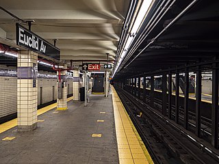
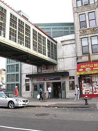
The Euclid Avenue station is an express station on the IND Fulton Street Line of the New York City Subway, located at the intersection of Euclid and Pitkin Avenues in East New York, Brooklyn. It is served by the A train at all times and is the southern terminal for the C train at all times except nights. During nights, this is the northern terminal for the Lefferts Boulevard shuttle train from Ozone Park, Queens.

<span class="mw-page-title-main">Hoyt–Schermerhorn Streets station</span> New York City Subway station in Brooklyn

The Hoyt–Schermerhorn Streets station is an express station of the New York City Subway, serving the IND Crosstown Line and the IND Fulton Street Line. Located at the intersection of Hoyt Street and Schermerhorn Street in Downtown Brooklyn, it is served by the A and G trains at all times, as well as the C train except at night.

<span class="mw-page-title-main">Liberty Avenue station</span> New York City Subway station in Brooklyn

The Liberty Avenue station is a local station on the IND Fulton Street Line of the New York City Subway, located at the intersection of Liberty and Pennsylvania Avenues in East New York, Brooklyn. It is served by the C train at all times except nights, when the A train takes over service.

<span class="mw-page-title-main">Van Siclen Avenue station (IND Fulton Street Line)</span> New York City Subway station in Brooklyn

The Van Siclen Avenue station is a local station on the IND Fulton Street Line of the New York City Subway. Located at the intersection of Van Siclen and Pitkin Avenues in the East New York neighborhood of Brooklyn, it is served by the C train at all times except nights, when the A train takes over service.

<span class="mw-page-title-main">Rockaway Avenue station (IND Fulton Street Line)</span> New York City Subway station in Brooklyn

The Rockaway Avenue station is a local station on the IND Fulton Street Line of the New York City Subway. Located at the intersection of Rockaway Avenue and Fulton Street in Brooklyn, it is served by the C train at all times except nights, when the A train takes over service.

<span class="mw-page-title-main">80th Street station (IND Fulton Street Line)</span> New York City Subway station in Queens

The 80th Street station is a station on the IND Fulton Street Line of the New York City Subway. Located on Liberty Avenue at 80th Street in Ozone Park, Queens, it is served by the A train at all times.

<span class="mw-page-title-main">Grant Avenue station (IND Fulton Street Line)</span> New York City Subway station in Brooklyn

The Grant Avenue station is a station on the IND Fulton Street Line of the New York City Subway. Located at Grant Avenue just north of Pitkin Avenue in City Line, Brooklyn, near the border between the boroughs of Brooklyn and Queens, it is served by the A train at all times. The station is the line's easternmost stop in Brooklyn; the Fulton Street Line continues east into Queens via the Fulton Street Elevated.

<span class="mw-page-title-main">88th Street station</span> New York City Subway station in Queens

The 88th Street station is a station on the IND Fulton Street Line of the New York City Subway. Located on Liberty Avenue at 88th Street in Ozone Park, Queens, it is served by the A train at all times.

<span class="mw-page-title-main">104th Street station (IND Fulton Street Line)</span> New York City Subway station in Queens

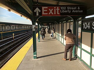
The 104th Street station is a station on the IND Fulton Street Line of the New York City Subway, located on Liberty Avenue at 104th Street in Ozone Park, Queens. The station is served by the Lefferts Boulevard branch of the A train at all times.

<span class="mw-page-title-main">Broadway Junction station</span> New York City Subway station in Brooklyn

The Broadway Junction station is a New York City Subway station complex shared by the elevated BMT Canarsie Line and BMT Jamaica Line, and the underground IND Fulton Street Line. It was also served by trains of the Fulton Street Elevated until that line closed in 1956. It is located roughly at the intersection of Broadway, Fulton Street and Van Sinderen Avenue at the border of Bedford–Stuyvesant and East New York, Brooklyn. The complex is served by the A, J, and L trains at all times; the C train at all times except late nights; and the Z train during rush hours in the peak direction only.

<span class="mw-page-title-main">Fulton Street Line (elevated)</span> Former New York City rapid transit line

The Fulton Street Line, also called the Fulton Street Elevated or Kings County Line, was an elevated rail line mostly in Brooklyn, New York City, United States. It ran above Fulton Street from Fulton Ferry, Brooklyn, in Downtown Brooklyn east to East New York, and then south on Van Sinderen Avenue (southbound) and Snediker Avenue (northbound), east on Pitkin Avenue, north on Euclid Avenue, and east on Liberty Avenue to Ozone Park, Queens.

The Rockaway Avenue station was a station on the demolished BMT Fulton Street Line in Brooklyn, New York City, served by the 13 train throughout its existence. It had two tracks and two side platforms, and a center island platform. It also had a connection to the Wilson Avenue Line trolleys. Rockaway Avenue was the easternmost station on the line until it was expanded to Atlantic Avenue on July 4, 1889. The next stop to the west was Saratoga Avenue until May 30, 1940, after which all stations on the line west of Rockaway Avenue were closed and a free transfer became available to the IND Fulton Street Line at the 1936-built subway station of the same name. The next stop to the east was Manhattan Junction. The station closed on April 26, 1956.

The Hinsdale Street station was a station on the demolished BMT Fulton Street Line in Brooklyn, New York City, at Pitkin Avenue and Hinsdale Street. It had 3 tracks and 2 side platforms. It opened on November 17, 1918, as a replacement for Eastern Parkway station one block to the west on Snediker Avenue, as part of the Dual Contracts, and had a connecting spur to the BMT Lexington Avenue Line via Manhattan Beach Crossing. It was served by BMT 13 trains until 1940, when they were replaced with BMT 12 trains. It also had a connection to the Bergen Street Line trolleys. It closed on April 26, 1956, along with the rest of the remaining segment of the Fulton Elevated Line west of Hudson Street. The station was not replaced with an underground IND Fulton Street Line station, which runs north along Pennsylvania Avenue towards Broadway Junction; the nearest existing station is Sutter Avenue on the BMT Canarsie Line.

References

  1. "Glossary". Second Avenue Subway Supplemental Draft Environmental Impact Statement (SDEIS) (PDF). Vol. 1. Metropolitan Transportation Authority. March 4, 2003. pp. 1–2. Archived from the original (PDF) on February 26, 2021. Retrieved January 1, 2021.
  2. 1 2 "Annual Subway Ridership (2018–2023)". Metropolitan Transportation Authority. 2023. Retrieved April 20, 2024.
  3. 1 2 Duffus, R.L. (September 22, 1929). "Our Great Subway Network Spreads Wider; New Plans of Board of Transportation Involve the Building of More Than One Hundred Miles of Additional Rapid Transit Routes for New York" (PDF). The New York Times . Archived (PDF) from the original on February 12, 2018. Retrieved August 19, 2015.
  4. Proposed Additional Rapid Transit Lines And Proposed Vehicular Tunnel. Board of Transportation of the City of New York Engineering Department. August 23, 1929. Archived from the original on January 22, 2018. Retrieved January 21, 2018.
  5. 1 2 3 4 "Trains Roll on $47,000,000 Fulton St. Subway Extension". Brooklyn Daily Eagle . November 29, 1948. p. 2. Archived from the original on October 28, 2016. Retrieved October 9, 2015 via Newspapers.com.
  6. 1 2 3 4 5 Raskin, Joseph B. (2013). The Routes Not Taken: A Trip Through New York City's Unbuilt Subway System. New York, New York: Fordham University Press. doi:10.5422/fordham/9780823253692.001.0001. ISBN   978-0-82325-369-2.
  7. 1 2 3 Linder, Bernard (February 2006). "Fulton Street Subway". New York Division Bulletin. 49 (2). Electric Railroader's Association: 2. Archived from the original on September 20, 2016. Retrieved August 27, 2016.
  8. Blauvelt, Paul (June 9, 1946). "Shortages Snarl $50,000,000 Tube Links". Brooklyn Daily Eagle . p. 21. Archived from the original on October 26, 2016. Retrieved October 9, 2015 via Newspapers.com.
  9. "Priorities May Halt Work on Fulton Tube: Vital Defense Materials Are Needed To Complete Spur to Queens County Line". Brooklyn Daily Eagle . November 18, 1941. p. 3. Archived from the original on January 27, 2017. Retrieved August 26, 2016 via Newspapers.com.
  10. Jaffe, Alfred (December 6, 1946). "Borough Subway Relief Still 2 or 3 Years Off". Brooklyn Daily Eagle . pp. 1, 5. Archived from the original on October 28, 2016. Retrieved October 9, 2015 via Newspapers.com.
  11. "Last Word in Subways and Cars for Boro". Brooklyn Daily Eagle . November 23, 1948. p. 8. Archived from the original on October 28, 2016. Retrieved October 9, 2015 via Newspapers.com.
  12. Sparberg, Andrew J. (October 2014). From a Nickel to a Token: The Journey from Board of Transportation to MTA. Fordham University Press. ISBN   978-0-8232-6190-1.
  13. "Fulton Subway Stations Open After All-Night 'Dry Runs'". Brooklyn Daily Eagle . November 28, 1948. Archived from the original on October 28, 2016. Retrieved October 9, 2015 via Newspapers.com.
  14. Report for the three and one-half years ending June 30, 1949. New York City Board of Transportation. 1949. hdl:2027/mdp.39015023094926.
  15. "Last Word in Subways and Cars for Boro". Brooklyn Daily Eagle . November 23, 1948. p. 8. Archived from the original on October 28, 2016. Retrieved October 9, 2015 via Newspapers.com.
  16. "First Leg of Rockaways Transit Opened at Cost of $10,154,702" (PDF). The New York Times . April 30, 1956. Archived (PDF) from the original on February 12, 2018. Retrieved June 29, 2015.
  17. Dougherty, Peter (2020). Tracks of the New York City Subway 2020 (16th ed.). Dougherty. OCLC   1056711733.
  18. "ASubway Timetable, Effective June 26, 2022". Metropolitan Transportation Authority . Retrieved August 26, 2023.
  19. "CSubway Timetable, Effective June 26, 2022". Metropolitan Transportation Authority . Retrieved August 26, 2023.
  20. "Subway Map" (PDF). Metropolitan Transportation Authority. September 2021. Retrieved September 17, 2021.
  21. "MTA Neighborhood Maps: Shepherd Av (C)". mta.info. Metropolitan Transportation Authority. September 2018. Archived from the original on September 29, 2019. Retrieved March 29, 2019.