List of New York City Subway stations in Queens

Last updated

The current New York City Transit Authority rail system map; Queens is located to the center and right portion of the map. NYC subway-4D.svg
The current New York City Transit Authority rail system map; Queens is located to the center and right portion of the map.

The New York City Subway is a rapid transit system that serves four of the five boroughs of New York City in the U.S. state of New York: the Bronx, Brooklyn, Manhattan, and Queens. Operated by the New York City Transit Authority under the Metropolitan Transportation Authority of New York, the New York City Subway is the busiest rapid transit system in the United States and the seventh busiest in the world, with 5.225 million daily riders. The system's 472 stations qualifies it to have the largest number of rapid transit stations in the world.

Contents

Three rapid transit companies merged in 1940 to create the present New York City Subway system: the Interborough Rapid Transit Company (IRT), the Brooklyn–Manhattan Transit Corporation (BMT), and the Independent Subway System (IND). All three former systems are present in Queens.

History and description

Until 1915 most rapid transit in Queens consisted of streetcars, primarily those owned by affiliates of the Brooklyn Rapid Transit Company, but some included trolleys owned by the Long Island Consolidated Electrical Companies, a holding company co-owned by the Long Island Rail Road and Interborough Rapid Transit Company. Some steam dummy lines also entered Queens from Brooklyn, most notably the Atlantic Avenue Rapid Transit lines along the Atlantic Branch and part of the Main Line of the Long Island Rail Road. As far back as 1885, proposals existed for a tunnel between Midtown Manhattan and Long Island City designed to connect the Long Island Rail Road and the New York Central and Hudson River Railroad with a trolley line. Construction hazards, economic despair, and the transfer of ownership of this project delayed completion of the tunnel. This tunnel would eventually be known as the Steinway Tunnel.

The oldest subway line in Queens is the BMT Myrtle Avenue Line which was extended from Brooklyn into Ridgewood and Middle Village, replacing a steam dummy line. This was followed by the IRT Flushing Line, which had only one station in Long Island City, until it was extended with Dual Contracts to Astoria in 1916, Corona on April 21, 1917, [1] and Downtown Flushing on January 2, 1928. [2] The BMT Fulton Street Line extended from the City Line section of Brooklyn into Ozone Park and Richmond Hill on September 25, 1915. [3] The same dual contracts project that brought about the extension of the IRT Flushing Line also lead to the opening of the BMT Astoria Line on February 1, 1917, [4] [5] as well as a connecting spur from the IRT Second Avenue Line over the Queensboro Bridge on July 23, 1917. [6] The Astoria Line was the northernmost line owned by the BMT. The BMT Broadway-Brooklyn Line entered Queens from the Cypress Hills section of Brooklyn and ran through Woodhaven and Richmond Hill on May 28, 1917, [7] and finally towards Downtown Jamaica on July 3, 1918. [8]

The city-owned Independent Subway System installed two lines in Queens on August 19, 1933; the IND Crosstown Line ran south from Court Square in Long Island City to Greenpoint in Brooklyn, [9] [10] [11] and was expanded to Downtown Brooklyn on July 1, 1937. [12] The IND Queens Boulevard Line entered from Manhattan and ran to Jackson Heights, then to Kew Gardens on December 31, 1936, [13] [14] [15] then to 169th Street in Jamaica on April 24, 1937. [14] [16] [17] One last station at 179th Street was built on December 10, 1950. From 1939 to 1940, IND installed a spur off the Queens Boulevard Line called the IND World's Fair Line. [9] [14] [18] The line was demolished after the closing of the 1939 World's Fair and the remnants can be found in the Jamaica Yard. A devastating fire on the trestle of the Rockaway Beach Branch of the Long Island Rail Road in Jamaica Bay in 1950 lead to the gradual closure of the branch, as well as part of the Far Rockaway Branch and the replacement of both by the IND Rockaway Line by 1956, replacing many but not all former LIRR stations. One other station (Far Rockaway–Mott Avenue) would be opened on February 21, 1958, and the LIRR replaced it with a new station three blocks east a month later. [19] [20] [21] [22] When the IND connected the Fulton Street Subway to the BMT Fulton Street Elevated on April 29, 1956, the former segments of the line in Ozone Park and Richmond Hill was officially "recaptured" by the IND. [23] [24]

The newest subway lines to be built were the Archer Avenue Lines, which opened on December 11, 1988, [25] [26] and replaced the demolished sections of the BMT Jamaica Line in Downtown Jamaica itself with an additional connecting spur to the IND Queens Boulevard Line, and the 63rd Street Lines on October 29, 1989 from the Upper East Side and Roosevelt Island.

Lines and services

There are 81 New York City Subway stations in Queens, per the official count of the Metropolitan Transportation Authority; of these, 10 are express-local stations. If the 2 station complexes are counted as one station each, the number of stations is 78. In the table below, lines with colors next to them indicate trunk lines, which determine the colors that are used for services' route bullets and diamonds. The opening date refers to the opening of the first section of track for the line. In the "division" column, the current division is followed by the original division in parentheses.

DivisionLineServicesStations in QueensOpenedContinues to
B (IND) 63rd Street Line October 29, 1989 Manhattan
B (BMT) Archer Avenue Lines December 11, 1988
B (IND) Archer Avenue Lines December 11, 1988
B (BMT) Astoria Line February 1, 1917 Manhattan
B (IND)  Crosstown Line August 19, 1933 Brooklyn
A (IRT)  Flushing Line 18 (4 express-local stations, 1 shared with Astoria Line, 2 part of station complexes)June 22, 1915 Manhattan
B (IND) Fulton Street Line April 29, 1956 Brooklyn
B (BMT) Jamaica Line May 28, 1917 Brooklyn
B (BMT) Myrtle Avenue Line February 22, 1915 Brooklyn
B (IND) Queens Boulevard Line 21 (4 express-local stations, 2 part of station complexes)August 19, 1933 Manhattan
B (IND) Rockaway Line 14June 28, 1956

Stations

Permanently closed subway stations, including those that have been demolished, are not included in the list below. Numerically named stations that are attached with a geographic location before them (Forest Hills–71st Avenue and Jamaica–179th Street) are listed under the geographic location name.

Station service legend
NYCS-SSI-alltimes.svg Stops all times
NYCS-SSI-allexceptnights.svg Stops all times except late nights
NYCS-SSI-nightsonly.svg Stops late nights only
NYCS-SSI-weekdaysonly.svg Stops weekdays during the day
NYCS-SSI-allexceptrush.svg Stops all times except rush hours in the peak direction
NYCS-SSI-allexceptrush.svg Stops all times except nights and rush hours in the peak direction
NYCS-SSI-rushonly.svg Stops rush hours only
NYCS-SSI-rushpeak.svg Stops rush hours in the peak direction only
Time period details
Wheelchair symbol.svg Station is compliant with the Americans with Disabilities Act
Wheelchair symbol.svg  Station is compliant with the Americans with Disabilities Act
in the indicated direction only
Wheelchair symbol.svg  
Aiga elevator.svg Elevator access to mezzanine only
*Station is part of a station complex
**Transfer stations either between local and express services or that involve the terminus of a service on the same line; may also be part of a station complex as defined above
***Multi-level or adjacent-platform transfer stations on different lines considered to be one station as classified by the MTA
Terminal of a service
*†, **† or ***†Transfer stations and terminals
Last station in Queens before service continues to Brooklyn or Manhattan
*‡, **‡, or ***‡Last station in Queens and a transfer station
*†‡, **†‡, or ***†‡Last station in Queens, a transfer station and a terminal
Station Wheelchair symbol.svg DivisionLineServicesOpened [27] [28] [29]
021st Street2 B (IND) Crosstown Line    G   NYCS-SSI-alltimes.svg August 19, 1933 [29]
021st Street–Queensbridge0 Wheelchair symbol.svg B (IND) 63rd Street Line    F   NYCS-SSI-alltimes.svg <F> NYCS-SSI-rushpeak.svg October 29, 1989 [30]
030th Avenue 2 B (BMT) Astoria Line    N   NYCS-SSI-alltimes.svg
   W   NYCS-SSI-weekdaysonly.svg
February 1, 1917 [28]
033rd Street–Rawson Street 2 A (IRT) Flushing Line    7   NYCS-SSI-alltimes.svg April 21, 1917 [27]
036th Avenue 2 B (BMT) Astoria Line    N   NYCS-SSI-alltimes.svg
   W   NYCS-SSI-weekdaysonly.svg
February 1, 1917 [28]
036th Street 2 B (IND) Queens Boulevard Line    E   NYCS-SSI-nightsonly.svg
   F   NYCS-SSI-nightsonly.svg
   M   NYCS-SSI-weekdaysonly.svg
   R   NYCS-SSI-allexceptnights.svg
August 19, 1933 [29]
039th Avenue 2 B (BMT) Astoria Line    N   NYCS-SSI-alltimes.svg
   W   NYCS-SSI-weekdaysonly.svg
February 1, 1917 [28]
040th Street–Lowery Street 2 A (IRT) Flushing Line    7   NYCS-SSI-alltimes.svg April 21, 1917 [27]
046th Street 2 B (IND) Queens Boulevard Line    E   NYCS-SSI-nightsonly.svg
   F   NYCS-SSI-nightsonly.svg
   M   NYCS-SSI-weekdaysonly.svg
   R   NYCS-SSI-allexceptnights.svg
August 19, 1933 [29]
046th Street–Bliss Street 2 A (IRT) Flushing Line    7   NYCS-SSI-alltimes.svg April 21, 1917 [27]
052nd Street 2 A (IRT) Flushing Line    7   NYCS-SSI-alltimes.svg April 21, 1917 [27]
61st Street–Woodside**0 Wheelchair symbol.svg A (IRT) Flushing Line    7   NYCS-SSI-alltimes.svg <7> NYCS-SSI-rushpeak.svg April 21, 1917 [27]
063rd Drive–Rego Park 2 B (IND) Queens Boulevard Line    E   NYCS-SSI-nightsonly.svg
   F   NYCS-SSI-nightsonly.svg
   M   NYCS-SSI-weekdaysonly.svg
   R   NYCS-SSI-allexceptnights.svg
December 31, 1936 [29]
065th Street 2 B (IND) Queens Boulevard Line    E   NYCS-SSI-nightsonly.svg
   F   NYCS-SSI-nightsonly.svg
   M   NYCS-SSI-weekdaysonly.svg
   R   NYCS-SSI-allexceptnights.svg
August 19, 1933 [29]
067th Avenue 2 B (IND) Queens Boulevard Line    E   NYCS-SSI-nightsonly.svg
   F   NYCS-SSI-nightsonly.svg
   M   NYCS-SSI-weekdaysonly.svg
   R   NYCS-SSI-allexceptnights.svg
December 31, 1936 [29]
069th Street 2 A (IRT) Flushing Line    7   NYCS-SSI-alltimes.svg April 21, 1917 [27]
074th Street–Broadway* [^ 2] 0 Wheelchair symbol.svg A (IRT) Flushing Line    7   NYCS-SSI-alltimes.svg April 21, 1917 [27]
075th Avenue 2 B (IND) Queens Boulevard Line    E   NYCS-SSI-nightsweekends.svg
   F   NYCS-SSI-alltimes.svg <F> NYCS-SSI-rushpeak.svg
December 31, 1936 [29]
075th Street–Elderts Lane2 B (BMT) Jamaica Line    J   NYCS-SSI-allexceptrush.svg
   Z   NYCS-SSI-rushpeak.svg
May 28, 1917 [28]
080th Street2 B (IND) Fulton Street Line    A   NYCS-SSI-alltimes.svg April 29, 1956 [29]
082nd Street–Jackson Heights 2 A (IRT) Flushing Line    7   NYCS-SSI-alltimes.svg April 21, 1917 [27]
085th Street–Forest Parkway 2 B (BMT) Jamaica Line    J   NYCS-SSI-alltimes.svg May 28, 1917 [28]
088th Street 2 B (IND) Fulton Street Line    A   NYCS-SSI-alltimes.svg April 29, 1956 [29]
090th Street–Elmhurst Avenue 2 A (IRT) Flushing Line    7   NYCS-SSI-alltimes.svg April 21, 1917 [27]
103rd Street–Corona Plaza 2 A (IRT) Flushing Line    7   NYCS-SSI-alltimes.svg April 21, 1917 [27]
104th Street 2 B (IND) Fulton Street Line    A   NYCS-SSI-alltimes.svg April 29, 1956 [29]
104th Street 2 B (BMT) Jamaica Line    J   NYCS-SSI-allexceptrush.svg
   Z   NYCS-SSI-rushpeak.svg
May 28, 1917 [28]
111th Street 2 A (IRT) Flushing Line    7   NYCS-SSI-alltimes.svg October 13, 1925 [27]
111th Street 2 B (IND) Fulton Street Line    A   NYCS-SSI-alltimes.svg April 29, 1956 [29]
111th Street 2 B (BMT) Jamaica Line    J   NYCS-SSI-alltimes.svg May 28, 1917 [28]
121st Street 2 B (BMT) Jamaica Line    J   NYCS-SSI-allexceptrush.svg
   Z   NYCS-SSI-rushpeak.svg
July 3, 1918 [28]
169th Street 2 B (IND) Queens Boulevard Line    F   NYCS-SSI-alltimes.svg <F> NYCS-SSI-rushpeak.svg April 24, 1937 [29]
Aqueduct Racetrack [^ 3] 0 Wheelchair symbol.svg   B (IND) Rockaway Line    A   NYCS-SSI-alltimes.svg June 28, 1956 [29]
Aqueduct–North Conduit Avenue 2 B (IND) Rockaway Line    A   NYCS-SSI-alltimes.svg June 28, 1956 [29]
Astoria Boulevard 0 Wheelchair symbol.svg B (BMT) Astoria Line    N   NYCS-SSI-alltimes.svg
   W   NYCS-SSI-weekdaysonly.svg
February 1, 1917 [28]
Astoria–Ditmars Boulevard2 B (BMT) Astoria Line    N   NYCS-SSI-alltimes.svg
   W   NYCS-SSI-weekdaysonly.svg
February 1, 1917 [28]
Beach 025Beach 25th Street 2 B (IND) Rockaway Line    A   NYCS-SSI-alltimes.svg June 28, 1956 [29]
Beach 036Beach 36th Street 2 B (IND) Rockaway Line    A   NYCS-SSI-alltimes.svg June 28, 1956 [29]
Beach 044Beach 44th Street 2 B (IND) Rockaway Line    A   NYCS-SSI-alltimes.svg June 28, 1956 [29]
Beach 060Beach 60th Street 2 B (IND) Rockaway Line    A   NYCS-SSI-alltimes.svg June 28, 1956 [29]
Beach 067Beach 67th Street 0 Wheelchair symbol.svg B (IND) Rockaway Line    A   NYCS-SSI-alltimes.svg June 28, 1956 [29]
Beach 090Beach 90th Street 2 B (IND) Rockaway Line    A   NYCS-SSI-rushpeak.svg
   S   NYCS-SSI-alltimes.svg
June 28, 1956 [29]
Beach 098Beach 98th Street 2 B (IND) Rockaway Line    A   NYCS-SSI-rushpeak.svg
   S   NYCS-SSI-alltimes.svg
June 28, 1956 [29]
Beach 105Beach 105th Street 2 B (IND) Rockaway Line    A   NYCS-SSI-rushpeak.svg
   S   NYCS-SSI-alltimes.svg
June 28, 1956 [29]
Briarwood 1 Aiga elevator.svg B (IND) Queens Boulevard Line    E   NYCS-SSI-nightsweekends.svg
   F   NYCS-SSI-alltimes.svg <F> NYCS-SSI-rushpeak.svg
April 24, 1937 [29]
Broad Channel**†2 B (IND) Rockaway Line    A   NYCS-SSI-alltimes.svg
   S   NYCS-SSI-alltimes.svg
June 28, 1956 [29]
Broadway 2 B (BMT) Astoria Line    N   NYCS-SSI-alltimes.svg
   W   NYCS-SSI-weekdaysonly.svg
February 1, 1917 [28]
0Court Square*‡ [^ 4] 0 Wheelchair symbol.svg A (IRT) Flushing Line    7   NYCS-SSI-alltimes.svg <7> NYCS-SSI-rushpeak.svg November 5, 1916 [27]
Court Square*† [^ 4] 0 Wheelchair symbol.svg B (IND) Crosstown Line    G   NYCS-SSI-alltimes.svg August 19, 1933 [29]
0Court Square–23rd Street*‡ [^ 4] 1 Aiga elevator.svg B (IND) Queens Boulevard Line    E   NYCS-SSI-alltimes.svg
   M   NYCS-SSI-weekdaysonly.svg
August 28, 1939 [31]
Elmhurst Avenue 2 B (IND) Queens Boulevard Line    E   NYCS-SSI-nightsonly.svg
   F   NYCS-SSI-nightsonly.svg
   M   NYCS-SSI-weekdaysonly.svg
   R   NYCS-SSI-allexceptnights.svg
December 31, 1936 [29]
Far Rockaway–Mott Avenue0 Wheelchair symbol.svg B (IND) Rockaway Line    A   NYCS-SSI-alltimes.svg January 16, 1958 [29]
Flushing–Main Street0 Wheelchair symbol.svg A (IRT) Flushing Line    7   NYCS-SSI-alltimes.svg <7> NYCS-SSI-rushpeak.svg January 21, 1928 [27]
Forest Avenue 2 B (BMT) Myrtle Avenue Line    M   NYCS-SSI-alltimes.svg February 22, 1915 [28]
Forest Hills–71st Avenue**†0 Wheelchair symbol.svg B (IND) Queens Boulevard Line    E   NYCS-SSI-alltimes.svg
   F   NYCS-SSI-alltimes.svg <F> NYCS-SSI-rushpeak.svg
   M   NYCS-SSI-weekdaysonly.svg
   R   NYCS-SSI-allexceptnights.svg
December 31, 1936 [29]
Fresh Pond Road 2 B (BMT) Myrtle Avenue Line    M   NYCS-SSI-alltimes.svg February 22, 1915 [28]
Grand Avenue–Newtown 2 B (IND) Queens Boulevard Line    E   NYCS-SSI-nightsonly.svg
   F   NYCS-SSI-nightsonly.svg
   M   NYCS-SSI-weekdaysonly.svg
   R   NYCS-SSI-allexceptnights.svg
December 31, 1936 [29]
Howard Beach–JFK Airport 0 Wheelchair symbol.svg B (IND) Rockaway Line    A   NYCS-SSI-alltimes.svg June 28, 1956 [29]
Hunters Point Avenue 2 A (IRT) Flushing Line    7   NYCS-SSI-alltimes.svg <7> NYCS-SSI-rushpeak.svg February 15, 1916 [27]
Jackson Heights–Roosevelt Avenue** [^ 2] 0 Wheelchair symbol.svg B (IND) Queens Boulevard Line    E   NYCS-SSI-alltimes.svg
   F   NYCS-SSI-alltimes.svg <F> NYCS-SSI-rushpeak.svg
   M   NYCS-SSI-weekdaysonly.svg
   R   NYCS-SSI-allexceptnights.svg
August 19, 1933 [29]
Jamaica Center–Parsons/Archer***†0 Wheelchair symbol.svg Archer Avenue lines    E   NYCS-SSI-alltimes.svg
   J   NYCS-SSI-alltimes.svg
   Z   NYCS-SSI-rushpeak.svg
December 11, 1988 [30] [32]
Jamaica–179th Street0 Wheelchair symbol.svg B (IND) Queens Boulevard Line    E   NYCS-SSI-rushonly.svg
   F   NYCS-SSI-alltimes.svg <F> NYCS-SSI-rushpeak.svg
December 10, 1950 [29]
Jamaica–Van Wyck 0 Wheelchair symbol.svg B (IND) Archer Avenue Line    E   NYCS-SSI-alltimes.svg December 11, 1988 [30]
Junction Boulevard**0 Wheelchair symbol.svg A (IRT) Flushing Line    7   NYCS-SSI-alltimes.svg <7> NYCS-SSI-rushpeak.svg April 21, 1917 [27]
Kew Gardens–Union Turnpike**0 Wheelchair symbol.svg B (IND) Queens Boulevard Line    E   NYCS-SSI-alltimes.svg
   F   NYCS-SSI-alltimes.svg <F> NYCS-SSI-rushpeak.svg
December 31, 1936 [29]
Mets–Willets Point**†0 Wheelchair symbol.svg   [^ 5] A (IRT) Flushing Line    7   NYCS-SSI-alltimes.svg <7> NYCS-SSI-rushpeak.svg May 14, 1927 [27]
Middle Village–Metropolitan Avenue0 Wheelchair symbol.svg B (BMT) Myrtle Avenue Line    M   NYCS-SSI-alltimes.svg February 22, 1915 [28]
Northern Boulevard 2 B (IND) Queens Boulevard Line    E   NYCS-SSI-nightsonly.svg
   F   NYCS-SSI-nightsonly.svg
   M   NYCS-SSI-weekdaysonly.svg
   R   NYCS-SSI-allexceptnights.svg
August 19, 1933 [29]
Ozone Park–Lefferts Boulevard0 Wheelchair symbol.svg B (IND) Fulton Street Line    A   NYCS-SSI-alltimes.svg April 29, 1956 [29]
Parsons Boulevard**2 B (IND) Queens Boulevard Line    E   NYCS-SSI-rushonly.svg
   F   NYCS-SSI-alltimes.svg <F> NYCS-SSI-rushpeak.svg
April 24, 1937 [29]
Queens Plaza**0 Wheelchair symbol.svg B (IND) Queens Boulevard Line    E   NYCS-SSI-alltimes.svg
   M   NYCS-SSI-weekdaysonly.svg
   R   NYCS-SSI-allexceptnights.svg
August 19, 1933 [29]
Queensboro Plaza***‡2 A (IRT),
B (BMT)
Astoria Line (BMT), Flushing Line (IRT)    7   NYCS-SSI-alltimes.svg <7> NYCS-SSI-rushpeak.svg
   N   NYCS-SSI-alltimes.svg
   W   NYCS-SSI-weekdaysonly.svg
November 5, 1916 [27]
Rockaway Boulevard* [^ 6] 2 B (IND) Fulton Street Line    A   NYCS-SSI-alltimes.svg April 29, 1956 [29]
Rockaway Park–Beach 116th Street0 Wheelchair symbol.svg B (IND) Rockaway Line    A   NYCS-SSI-rushpeak.svg
   S   NYCS-SSI-alltimes.svg
June 28, 1956 [29]
Seneca Avenue2 B (BMT) Myrtle Avenue Line    M   NYCS-SSI-alltimes.svg February 22, 1915 [28]
Steinway Street 2 B (IND) Queens Boulevard Line    E   NYCS-SSI-nightsonly.svg
   F   NYCS-SSI-nightsonly.svg
   M   NYCS-SSI-weekdaysonly.svg
   R   NYCS-SSI-allexceptnights.svg
August 19, 1933 [29]
Sutphin Boulevard 2 B (IND) Queens Boulevard Line    F   NYCS-SSI-alltimes.svg <F> NYCS-SSI-rushpeak.svg April 24, 1937 [29]
Sutphin Boulevard–Archer Avenue–JFK Airport***0 Wheelchair symbol.svg Archer Avenue lines    E   NYCS-SSI-alltimes.svg
   J   NYCS-SSI-alltimes.svg
   Z   NYCS-SSI-rushpeak.svg
December 11, 1988 [30] [32]
Vernon Boulevard–Jackson Avenue2 A (IRT) Flushing Line    7   NYCS-SSI-alltimes.svg <7> NYCS-SSI-rushpeak.svg June 22, 1915 [27]
Woodhaven Boulevard**2 B (BMT) Jamaica Line    J   NYCS-SSI-alltimes.svg
   Z   NYCS-SSI-rushpeak.svg
May 28, 1917 [28]
Woodhaven Boulevard 2 B (IND) Queens Boulevard Line    E   NYCS-SSI-nightsonly.svg
   F   NYCS-SSI-nightsonly.svg
   M   NYCS-SSI-weekdaysonly.svg
   R   NYCS-SSI-allexceptnights.svg
December 31, 1936 [29]

See also

Notes

  1. 1 2 As the J/Z combined in a skip-stop service, an "express-local" station in this sense means both services stop at the station during the hours of skip-stop operation.
  2. 1 2 The 2 platform sets of the Jackson Heights–Roosevelt Avenue/74th Street station complex count as one station when compared to international standards.
  3. The platform is on the northbound side only.
  4. 1 2 3 The 3 platform sets of the Court Square–23rd Street station complex count as one station when compared to international standards.
  5. The Mets–Willets Point station is disability-accessible on the northbound side platform only. Northbound local trains will open their doors on this platform during New York Mets game days and special events only.
  6. The transfer at Rockaway Boulevard is between A trains going to/from Ozone Park–Lefferts Boulevard and A trains going to/from Far Rockaway–Mott Avenue or Rockaway Park–Beach 116th Street.

Related Research Articles

<span class="mw-page-title-main">E (New York City Subway service)</span> New York City Subway service

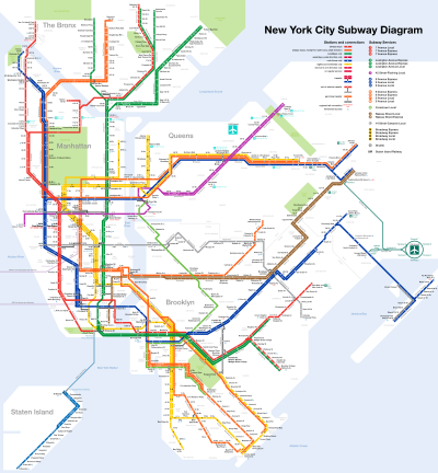
The E Queens Boulevard Express/
Eighth Avenue Local
is a rapid transit service in the B Division of the New York City Subway. Its route emblem, or "bullet", is blue since it uses the IND Eighth Avenue Line in Manhattan.

<span class="mw-page-title-main">Brooklyn–Manhattan Transit Corporation</span> Defunct transit operator in New York City

The Brooklyn–Manhattan Transit Corporation (BMT) was an urban transit holding company, based in Brooklyn, New York City, United States, and incorporated in 1923. The system was sold to the city in 1940. Today, together with the IND subway system, it forms the B Division of the modern New York City Subway.

<span class="mw-page-title-main">Independent Subway System</span> Defunct subway operator in New York City

The Independent Subway System was a rapid transit rail system in New York City that is now part of the New York City Subway. It was first constructed as the Eighth Avenue Line in Manhattan in 1932. It was originally also known as the Independent City-Owned Subway System (ICOSS) or the Independent City-Owned Rapid Transit Railroad (ICORTR).

<span class="mw-page-title-main">Proposed expansion of the New York City Subway</span>

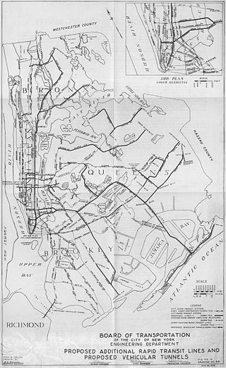
Since the opening of the original New York City Subway line in 1904, and throughout the subway's history, various official and planning agencies have proposed numerous extensions to the subway system. The first major expansion of the subway system was the Dual Contracts, a set of agreements between the City of New York and the IRT and the BRT. The system was expanded into the outer reaches of the Bronx, Brooklyn, and Queens, and it provided for the construction of important lines in Manhattan. This one expansion of the system provided for a majority of today's system.

The BMT Jamaica Line, also known as the Broadway - Brooklyn Line, is an elevated rapid transit line of the B Division of the New York City Subway, in Brooklyn and Queens, New York City, United States. It runs from the Williamsburg Bridge southeast over Broadway to East New York, Brooklyn, and then east over Fulton Street and Jamaica Avenue to Jamaica, Queens. In western Jamaica, the line goes into a tunnel, becoming the lower level of the Archer Avenue lines in central Jamaica. The J and Z trains serve the entire length of the Jamaica Line, and the M serves the line west of Myrtle Avenue.

Starting in 1899, the Brooklyn Rapid Transit Company and Brooklyn–Manhattan Transit Corporation operated rapid transit lines in New York City — at first only elevated railways and later also subways.

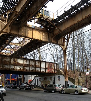
The IND Fulton Street Line is a rapid transit line of the IND Division of the New York City Subway, running from the Cranberry Street Tunnel under the East River through central Brooklyn to a terminus in Ozone Park, Queens. The IND Rockaway Line branches from it just east of Rockaway Boulevard. The A train runs express during daytime hours and local at night on the underground portion of the line; it runs local on the elevated portion of the line at all times. The C train runs local on the underground portion of the line at all times except late nights.

<span class="mw-page-title-main">111th Street station (IND Fulton Street Line)</span> New York City Subway station in Queens

The 111th Street station is a station on the IND Fulton Street Line of the New York City Subway, located on Liberty Avenue at 111th Street in Richmond Hill, Queens. The station is served by the A train at all times.

<span class="mw-page-title-main">104th Street station (IND Fulton Street Line)</span> New York City Subway station in Queens

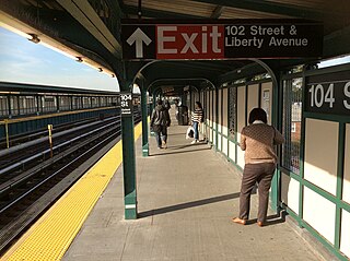
The 104th Street station is a station on the IND Fulton Street Line of the New York City Subway, located on Liberty Avenue at 104th Street in Ozone Park, Queens. The station is served by the Lefferts Boulevard branch of the A train at all times.

Woodhaven Boulevard and Cross Bay Boulevard are two parts of a major boulevard in the New York City borough of Queens. Woodhaven Boulevard runs roughly north–south in the central portion of Queens. South of Liberty Avenue, it is known as Cross Bay Boulevard, which is the main north–south road in Howard Beach. Cross Bay Boulevard is locally known as simply "Cross Bay", and Woodhaven Boulevard, "Woodhaven". The completion of the boulevard in 1923, together with the construction of the associated bridges over Jamaica Bay, created the first direct roadway connection to the burgeoning Atlantic Ocean beachfront communities of the Rockaway Peninsula from Brooklyn and most of Queens.

The New York City Subway's B Division consists of the lines that operate with lettered services, as well as the Franklin Avenue and Rockaway Park Shuttles. These lines and services were operated by the Brooklyn–Manhattan Transit Corporation (BMT) and city-owned Independent Subway System (IND) before the 1940 city takeover of the BMT. B Division rolling stock is wider, longer, and heavier than those of the A Division, measuring 10 or 9.75 ft by 60 or 75 ft.

<span class="mw-page-title-main">Brooklyn Manor station</span> Former railroad station in New York City

The Brooklyn Manor station was a station on the Long Island Rail Road's Rockaway Beach Branch located on the south side of Jamaica Avenue at 100th Street, straddling the border between Richmond Hill and Woodhaven in Queens, New York City. The station name referred to the nearby Brooklyn Manor section of Woodhaven, originally a 603-lot development bounded by Woodhaven Boulevard to the west, 96th/98th Streets to the east, Forest Park to the north, and Jamaica Avenue to the south. The station opened in January 1911, and was constructed as a replacement for the Brooklyn Hills station, which was located 3,000 feet (910 m) to the north. This station closed along with the rest of the Rockaway Beach Branch in 1962, and was subsequently demolished.

The Queens Boulevard station was a local station on the demolished section of the BMT Jamaica Line in Queens, New York City. It had two tracks and two side platforms, with space for a third track in the center. This station was built as part of the Dual Contracts. It opened on July 3, 1918, and was closed in 1985 in anticipation of the Archer Avenue Subway, and due to political pressure in the area. The next stop to the north was Sutphin Boulevard, until it was closed in 1977 and Queens Boulevard became a terminal station. The next stop to the south was Metropolitan Avenue.

<span class="mw-page-title-main">168th Street station (BMT Jamaica Line)</span> New York City Subway station in Queens (closed 1977)

The 168th Street station was the terminal station on the demolished section of the BMT Jamaica Line in Queens, New York City. It was located between 165th and 168th Streets on Jamaica Avenue.

References

  1. "Transit Service on Corona Extension of Dual Subway System Opened to the Public". The New York Times. April 22, 1917. p. RE1. Retrieved October 2, 2011.
  2. Sheridan, Dick (April 12, 1999). "MOVING UP ON MAIN ST. ESCALATORS READY AT SUBWAY STATION". New York Daily News . Retrieved September 18, 2015.
  3. New York Times , New Elevated Line Opened for Queens, September 26, 1915, page 7
  4. "First Train Runs On Elevated Line to Astoria Section". Brooklyn Daily Eagle . February 1, 1917. Retrieved June 29, 2015 via Newspapers.com.
  5. Annual report. 1916-1917. New York: Interborough Rapid Transit Company. 1917.
  6. "Subway Link Over Queensboro Bridge". The New York Times. July 22, 1917. p. 31. Retrieved December 18, 2011.
  7. 1 2 Raskin, Joseph B. (2013). The Routes Not Taken: A Trip Through New York City's Unbuilt Subway System. New York, New York: Fordham University Press. doi:10.5422/fordham/9780823253692.001.0001. ISBN   978-0-82325-369-2.
  8. "Independent Subway Services Beginning in 1932". thejoekorner.com. August 21, 2013. Retrieved August 2, 2015.
  9. "TWO SUBWAY UNITS OPEN AT MIDNIGHT; Links in City-Owned System in Queens and Brooklyn to Have 15 Stations" (PDF). The New York Times . August 18, 1933. Retrieved November 7, 2015.
  10. "New Crosstown Subway Line Is Opened". Brooklyn Daily Eagle . July 1, 1937. Retrieved December 24, 2015.
  11. "Reproduction Poster of Extension to Union Turnpike–Kew Gardens". Flickr – Photo Sharing!. October 2015. Retrieved April 26, 2016.
  12. 1 2 3 Roger P. Roess; Gene Sansone (August 23, 2012). The Wheels That Drove New York: A History of the New York City Transit System. Springer Science & Business Media. pp. 416–417. ISBN   978-3-642-30484-2.
  13. "PWA Party Views New Subway Link: Queens Section to Be Opened Tomorrow Is Inspected by Tuttle and Others" (PDF). The New York Times . December 30, 1936. Retrieved June 27, 2015.
  14. "Subway Link Opens Soon: City Line to Jamaica Will Start About April 24" (PDF). The New York Times . March 17, 1937. Retrieved June 27, 2015.
  15. "Trial Run to Jamaica on Subway Tomorrow: Section From Kew Gardens to 169th Street Will Open to Public in Two Weeks" (PDF). The New York Times . April 9, 1937. Retrieved June 30, 2015.
  16. "TO BUILD FAIR SUBWAY P. T. Cox Co. Wins Award for Extending Independent System The first contract for the World's Fair spur from the Queens Boulevard line of the Independent Subway System was awarded yesterday by the Board of Transportation to the lowest bidder, the P. T. Cox Contracting Company, at the bid price of $308,770" (PDF). The New York Times . October 27, 1937. Retrieved July 6, 2015.
  17. Lucev, Emil (June 18, 2010). "Historical Views of the Rockaways: The old Far Rockaway Station Plaza, Mott and Central Avenues, 1922". rockawave.com . The Wave . Retrieved June 29, 2015.
  18. "Shop Center Due in Far Rockaway: Market and Big Parking Lot to Replace L.I. Station Being Moved 2 Blocks" (PDF). The New York Times . July 6, 1956. Retrieved June 29, 2015.
  19. "L.I.R.R. to Shift Station" (PDF). The New York Times . April 5, 1957. Retrieved June 29, 2015.
  20. IND Rockaway Branch/Jamaica Bay Crossing, accessed June 14, 2006
  21. Sparberg, Andrew J. (October 1, 2014). From a Nickel to a Token: The Journey from Board of Transportation to MTA. Fordham University Press. ISBN   978-0-8232-6190-1.
  22. Freeman, Ira Henry (June 28, 1956). "Rockaway Trains to Operate Today" (PDF). The New York Times . Retrieved June 29, 2015.
  23. Johnson, Kirk (December 9, 1988). "Big Changes For Subways Are to Begin". The New York Times. ISSN   0362-4331 . Retrieved June 6, 2016.
  24. "New Subway Line Finally Rolling Through Queens", Newsday, December 11, 1988, page 7.
  25. 1 2 3 4 5 6 7 8 9 10 11 12 13 14 15 16 17 18 19 Fischler, p. 239-240
  26. 1 2 3 4 5 6 7 8 9 10 11 12 13 14 15 16 17 Fischler, p. 241-242
  27. 1 2 3 4 5 6 7 8 9 10 11 12 13 14 15 16 17 18 19 20 21 22 23 24 25 26 27 28 29 30 31 32 33 34 35 36 37 38 39 40 41 42 43 Fischler, p. 243-244
  28. 1 2 3 4 "New York City Subway IND Division Timeline". www.nycsubway.org. Retrieved May 31, 2009.
  29. Feinman, Mark (2000). "The History of the Independent Subway" . Retrieved July 3, 2006.
  30. 1 2 "New York City Subway BMT Division Timeline". www.nycsubway.org. Retrieved May 31, 2009.

Further reading