Nassau Avenue station

Last updated

 Nassau Avenue
  NYCS-bull-trans-G-Std.svg
MTA NYC logo.svg New York City Subway station (rapid transit)
Nassau Avenue August 2017 01.jpg
View from northbound platform
Station statistics
AddressNassau Avenue & Manhattan Avenue
Brooklyn, NY
Borough Brooklyn
Locale Greenpoint
Coordinates 40°43′26″N73°57′03″W / 40.723811°N 73.95082°W / 40.723811; -73.95082
Division B (IND) [1]
Line     IND Crosstown Line
Services    G   NYCS-SSI-alltimes.svg (all times)
TransitAiga bus trans.svg NYCT Bus: B43, B48, B62
StructureUnderground
Platforms2 side platforms
Tracks2
Other information
OpenedAugust 19, 1933;90 years ago (August 19, 1933) [2]
Opposite-
direction
transfer
Yes
Traffic
20232,320,186 [3] Increase2.svg 19.5%
Rank144 out of 423 [3]
Services
Preceding station MTA NYC logo.svg New York City Subway Following station
Greenpoint Avenue
toward Court Square
NYCS-bull-trans-G-Std.svg Metropolitan Avenue
Location
NYCS map blank.svg
Map pointer.svg
USA New York City location map.svg
Map pointer.svg
USA New York location map.svg
Map pointer.svg
Track layout

Contents

BSicon MFADEg.svg
BSicon uvSTR.svg
BSicon uvSTRfg.svg
BSicon uvUST.svg
BSicon numN030.svg
BSicon dPLTl.svg
BSicon uvSTR.svg
BSicon dPLTr.svg
BSicon dPLTl.svg
BSicon uvSTR.svg
BSicon dPLTr.svg
BSicon dPLTl.svg
BSicon uvSTR.svg
BSicon dPLTr.svg
BSicon dPLTl.svg
BSicon uvSTR.svg
BSicon dPLTr.svg
BSicon uvSTRfg.svg
BSicon MFADEf.svg
BSicon uvSTR.svg
Street map

Nassau Avenue station

Station service legend
SymbolDescription
NYCS-SSI-alltimes.svg Stops all times

The Nassau Avenue station is a station on the IND Crosstown Line of the New York City Subway. Located at the intersection of Manhattan and Nassau Avenues in Greenpoint, Brooklyn, it is served by the G train at all times.

History

This station opened on August 19, 1933 as the initial terminal station for the IND Crosstown Line. [2] With the completion of the Crosstown Line on July 1, 1937, Nassau Avenue ceased to be the line's terminal. [4] [5]

New York City councilmember Lincoln Restler founded a volunteer group, the Friends of MTA Station Group, in early 2023 to advocate for improvements to the Nassau Avenue station and four other subway stations in Brooklyn. [6] [7]

Station layout

GroundStreet levelEntrances/exits
MezzanineStation agent, fare control, MetroCard machines
Basement 2 Side platform
Northbound NYCS-bull-trans-G-Std.svg toward Court Square (Greenpoint Avenue)
Southbound NYCS-bull-trans-G-Std.svg toward Church Avenue (Metropolitan Avenue)
Side platform
Station stair with bike racks Nassau Avenue - Stairs.JPG
Station stair with bike racks

This underground station has two tracks and two side platforms. [8] [9] The G stops at the station at all times. [10] The station is between Greenpoint Avenue to the north and Metropolitan Avenue to the south. [11]

Both platforms have a green trim line with a black border and mosaic name tablets reading "NASSAU AVE." in white sans-serif lettering on a black background and green border. Small "NASSAU" tile captions in white lettering on a black background run directly below the trim line and directional signs in the same style are below some of the name tablets. The tiles were part of a color-coded tile system used throughout the IND. [12] The tile colors were designed to facilitate navigation for travelers going away from Lower Manhattan. Because the Crosstown Line does not merge into a line that enters Manhattan at either end, all stations on the line had green tiles. [13] [14] Green I-beam columns run along both platforms at regular intervals with alternating ones having the standard black name plate in white lettering. [2]

North of the station is a diamond crossover switch, allowing terminating trains to reverse direction. [8] [9] [15] These switches were used in regular service until July 1, 1937, when the remainder of the Crosstown Line opened. [4] [5] Prior to that, Nassau Avenue was the line's southern terminus. [2] [16] [17] South of the station, the line shifts from Manhattan Avenue onto Union Avenue, running diagonally under McCarren Park. [18]

Exits

The station's full-time fare control is at the south end, which is the more heavily used of the station's two entry-exit points. A short staircase from each platform goes up to mezzanine level. On the Church Avenue-bound side, one exit-only turnstile and one High Entry/Exit Turnstile leads to two staircases going up to either western corners of Manhattan and Nassau Avenues. The Queens-bound side has the station's full-time turnstile bank, token booth, and two staircases going up to either eastern corners of the same intersection. A raised crossover connects the two sides both inside and outside fare control and is split in two by a steel fence. The mezzanine has mosaic directional signs in white lettering on a green background. [8] [18] G trains, which are about half the length of the 600-foot (180 m) platform, stop near the south end of the station. [8] [15]

Both platforms have an unstaffed platform-level fare control at their north end, with no crossover. On the Church Avenue-bound side, one exit-only turnstile and one High Entry/Exit Turnstile lead to a single staircase going up to the northwest corner of Norman and Manhattan Avenues. On the Queens-bound side, a single full height turnstile leads to a staircase going up to the northeast corner of the same intersection. [8] [18]

In preparation for the 14th Street Tunnel shutdown in 2019, it was initially planned to reconfigure the split free/paid area at the south end of the station into an exclusively unpaid area. This would have removed the free transfer between platforms, but would have allowed for increased flow from passengers entering and exiting the station. [19] Though this was not done,[ citation needed ] a project to replace high-entry/exit turnstiles at the station with four low turnstiles was completed in January 2019. [20]

Related Research Articles

<span class="mw-page-title-main">Fulton Street station (IND Crosstown Line)</span> New York City Subway station in Brooklyn

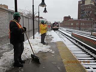
The Fulton Street station is a station on the IND Crosstown Line of the New York City Subway, located on Lafayette Avenue between South Portland Avenue and Fulton Street in Brooklyn. It is served by the G train at all times.

<span class="mw-page-title-main">Church Avenue station (IND Culver Line)</span> New York City Subway station in Brooklyn

The Church Avenue station is an express station on the IND Culver Line of the New York City Subway. Located at Church and McDonald Avenues in Kensington, Brooklyn, it is served by the F and G trains at all times, and by the <F> train during rush hours in the peak direction.

<span class="mw-page-title-main">Carroll Street station</span> New York City Subway station in Brooklyn

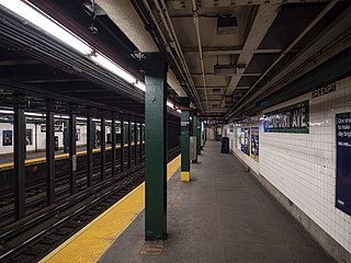
The Carroll Street station is a local station on the IND Culver Line of the New York City Subway, located in the neighborhood of Carroll Gardens, Brooklyn, at Carroll and Smith Streets. It is served by the F and G trains at all times.

<span class="mw-page-title-main">Seventh Avenue station (IND Culver Line)</span> New York City Subway station in Brooklyn

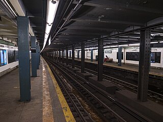
The Seventh Avenue station is an express station on the IND Culver Line of the New York City Subway, located at Seventh Avenue and Ninth Street in the Park Slope neighborhood of Brooklyn. It is served by the F and G trains at all times, and by the <F> train during rush hours in the peak direction.

<span class="mw-page-title-main">Fort Hamilton Parkway station (IND Culver Line)</span> New York City Subway station in Brooklyn

The Fort Hamilton Parkway station is a local station on the IND Culver Line of the New York City Subway. It is served by the F and G trains at all times.

<span class="mw-page-title-main">Lorimer Street station (BMT Jamaica Line)</span> New York City Subway station in Brooklyn

The Lorimer Street station is a local station on the BMT Jamaica Line of the New York City Subway. Located at the intersection of Lorimer Street and Broadway in Brooklyn, it is served by the J train at all times except weekdays in the peak direction and the M train at all times except late nights. The Z train skips this station when it operates.

<span class="mw-page-title-main">46th Street station (IND Queens Boulevard Line)</span> New York City Subway station in Queens

The 46th Street station is a local station on the IND Queens Boulevard Line of the New York City Subway. Located at the intersection of 46th Street and Broadway in Astoria, Queens, it is served by the M train on weekdays, the R train at all times except nights, and the E and F trains at night.

<span class="mw-page-title-main">Steinway Street station</span> New York City Subway station in Queens

The Steinway Street station is a local station on the IND Queens Boulevard Line of the New York City Subway. Located under Steinway Street between Broadway and 34th Avenue, it is served by the M train on weekdays, the R train at all times except nights, and the E and F trains at night.

<span class="mw-page-title-main">36th Street station (IND Queens Boulevard Line)</span> New York City Subway station in Queens

The 36th Street station is a local station on the IND Queens Boulevard Line of the New York City Subway. Located at the intersection of 36th Street and Northern Boulevard in Queens, it is served by the M train on weekdays, the R train at all times except nights, and the E and F trains at night. The <F> train skips this station when it operates.

<span class="mw-page-title-main">Court Square–23rd Street station</span> New York City Subway station in Queens

The Court Square–23rd Street station is a New York City Subway station complex on the IND Crosstown Line, the IRT Flushing Line and the IND Queens Boulevard Line. The complex is located in the vicinity of One Court Square in Hunters Point and Long Island City, Queens, and is served by the 7, E, and G trains at all times; the M train on weekdays; and the <7> express train during weekdays in the peak direction.

<span class="mw-page-title-main">21st Street station (IND Crosstown Line)</span> New York City Subway station in Queens

The 21st Street station is a station on the IND Crosstown Line of the New York City Subway. Located at the intersection of 21st Street and Jackson Avenue in the Hunters Point section of Long Island City, Queens, it is served by the G train at all times.

<span class="mw-page-title-main">Greenpoint Avenue station</span> New York City Subway station in Brooklyn

The Greenpoint Avenue station is a station on the IND Crosstown Line of the New York City Subway. Located at the intersection of Greenpoint and Manhattan Avenues in Greenpoint, Brooklyn, it is served by the G train at all times.

<span class="mw-page-title-main">Broadway station (IND Crosstown Line)</span> New York City Subway station in Brooklyn

The Broadway station is a station on the IND Crosstown Line of the New York City Subway. Located at the intersection of Broadway and Union Avenue in Williamsburg, Brooklyn, it is served at all times by the G train.

<span class="mw-page-title-main">Flushing Avenue station (IND Crosstown Line)</span> New York City Subway station in Brooklyn

The Flushing Avenue station is a station on the IND Crosstown Line of the New York City Subway. Located at the intersection of Flushing and Union/Marcy Avenues in the boundary of Bedford–Stuyvesant and Williamsburg, Brooklyn, it is served at all times by the G train.

<span class="mw-page-title-main">Myrtle–Willoughby Avenues station</span> New York City Subway station in Brooklyn

The Myrtle–Willoughby Avenues station is a station on the IND Crosstown Line of the New York City Subway. Located at the intersection of Myrtle and Marcy Avenues in Bedford–Stuyvesant, Brooklyn, it is served by the G train at all times. There are no open exits at Willoughby Avenue.

<span class="mw-page-title-main">Bedford–Nostrand Avenues station</span> New York City Subway station in Brooklyn

The Bedford–Nostrand Avenues station is a station on the IND Crosstown Line of the New York City Subway. Located at Lafayette Avenue between Bedford and Nostrand Avenues in Bedford–Stuyvesant, Brooklyn, it is served by the G train at all times.

<span class="mw-page-title-main">Classon Avenue station</span> New York City Subway station in Brooklyn

The Classon Avenue station is a station on the IND Crosstown Line of the New York City Subway. Located at the intersection of Classon and Lafayette Avenues on the border of Bedford–Stuyvesant and Clinton Hill, Brooklyn, it is served at all times by the G train.

<span class="mw-page-title-main">Clinton–Washington Avenues station (IND Crosstown Line)</span> New York City Subway station in Brooklyn

The Clinton–Washington Avenues station is a station on the IND Crosstown Line of the New York City Subway. Located at Lafayette Avenue between Clinton and Washington Avenues in Clinton Hill, Brooklyn, it is served by the G train at all times.

<span class="mw-page-title-main">Fourth Avenue/Ninth Street station</span> New York City Subway station in Brooklyn

The Fourth Avenue/Ninth Street station is a New York City Subway station complex shared by the elevated IND Culver Line and the underground BMT Fourth Avenue Line. It is located at the intersection of Ninth Street and Fourth Avenue in Park Slope, Brooklyn and served by the:

<span class="mw-page-title-main">Metropolitan Avenue/Lorimer Street station</span> New York City Subway station in Brooklyn

The Metropolitan Avenue/Lorimer Street station is an underground New York City Subway station complex shared by the BMT Canarsie Line and the IND Crosstown Line. Located in the Williamsburg neighborhood of Brooklyn, the complex is served by the G and L trains at all times.

References

  1. "Glossary". Second Avenue Subway Supplemental Draft Environmental Impact Statement (SDEIS) (PDF). Vol. 1. Metropolitan Transportation Authority. March 4, 2003. pp. 1–2. Archived from the original (PDF) on February 26, 2021. Retrieved January 1, 2021.
  2. 1 2 3 4 "Two Subway Units Open At Midnight; Links in City-Owned System in Queens and Brooklyn to Have 15 Stations" (PDF). The New York Times . August 18, 1933. Retrieved November 7, 2015.
  3. 1 2 "Annual Subway Ridership (2018–2023)". Metropolitan Transportation Authority. 2023. Retrieved April 20, 2024.
  4. 1 2 "New Crosstown Subway Line Is Opened". Brooklyn Daily Eagle. July 1, 1937. Retrieved December 24, 2015.
  5. 1 2 Kramer, Frederick A. (January 1, 1990). Building the Independent Subway. Quadrant Press. ISBN   9780915276509.
  6. Brendlen, Kirstyn (February 24, 2023). "Restler launches new 'Friends of MTA Station' initiative to care for 5 local subway stops". Brooklyn Paper. Retrieved May 6, 2023.
  7. Nessen, Stephen (March 5, 2023). "Want to be 'friends' with a subway station? A Brooklyn councilmember seeks volunteers". Gothamist. Retrieved May 6, 2023.
  8. 1 2 3 4 5 "Review of the G Line: Appendices" (PDF). Metropolitan Transportation Authority. July 10, 2013. Retrieved October 28, 2015.
  9. 1 2 Dougherty, Peter (2006) [2002]. Tracks of the New York City Subway 2006 (3rd ed.). Dougherty. OCLC   49777633 via Google Books.
  10. "GSubway Timetable, Effective July 2, 2023". Metropolitan Transportation Authority . Retrieved August 26, 2023.
  11. "Subway Map" (PDF). Metropolitan Transportation Authority. September 2021. Retrieved September 17, 2021.
  12. "Tile Colors a Guide in the New Subway; Decoration Scheme Changes at Each Express Stop to Tell Riders Where They Are". The New York Times. August 22, 1932. ISSN   0362-4331. Archived from the original on July 1, 2022. Retrieved July 1, 2022.
  13. Carlson, Jen (February 18, 2016). "Map: These Color Tiles In The Subway System Used To Mean Something". Gothamist. Archived from the original on May 10, 2023. Retrieved May 10, 2023.
  14. Gleason, Will (February 18, 2016). "The hidden meaning behind the New York subway's colored tiles". Time Out New York. Archived from the original on May 10, 2023. Retrieved May 10, 2023.
  15. 1 2 "Review of the G Line" (PDF). mta.info . Metropolitan Transportation Authority. July 10, 2013. Retrieved August 2, 2015.
  16. "Independent Subway Services Beginning in 1932". thejoekorner.com. August 21, 2013. Retrieved August 2, 2015.
  17. O'Neill, Natalie (July 19, 2012). "G wiz! MTA plans to save the G train extension!". The Brooklyn Paper . Retrieved July 21, 2012.
  18. 1 2 3 "MTA Neighborhood Maps: Greenpoint" (PDF). Metropolitan Transportation Authority. 2015. Retrieved November 7, 2015.
  19. New York City Transit Authority (July 2018). "MTA New York City Transit Canarsie Tunnel Project Supplemental Environmental Assessment and Section 4(f) Review: Final Report" (PDF). mta.info. Metropolitan Transportation Authority. p. 15. Retrieved July 27, 2018.
  20. "MTA Investment Reconfiguration of Fare Control Areas (FCA) Replace High Entry/Exit Turnstiles (HEETs) with Low Entry Turnstiles (TS)". archive.org. Metropolitan Transportation Authority. 2021. Retrieved May 27, 2024.