
Bridgend County Borough is a county borough in the south-east of Wales. The county borough has a total population of 139,200 people, and contains the town of Bridgend, after which it is named. Its members of the Senedd are Sarah Murphy MS, representing the Bridgend Constituency, and Huw Irranca-Davies MS representing the Ogmore Constituency, and its members of the UK parliament are Jamie Wallis and Chris Elmore.

The Borough of Ogwr was one of six districts of Mid Glamorgan in Wales, which existed from 1974 to 1996.
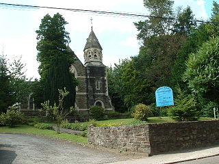
Tondu is a village in Bridgend County Borough, Wales, located about 3 miles (4.8 km) north of the town of Bridgend, in the community of Ynysawdre.

Ogmore is a constituency created in 1918 represented in the House of Commons of the UK Parliament by Chris Elmore of the Labour Party.
The Garw Valley Railway is the trading name of the Bridgend Valleys Railway Company Limited. It operates a short section of 4 ft 8+1⁄2 instandard gauge railway located in South Wales, which is being recreated as a heritage railway. Formerly part of the Llynvi and Ogmore Railway (L&OR) and built by the Great Western Railway (GWR), the line was used for freight and passenger services, with most of the track still in place between Brynmenyn and Pontycymer. The project currently has a train shed at Pontycymer, and hopes to initially offer brake van rides between Pontycymer and Pant-y-Gog, a distance of 0.5 miles (0.8 km).

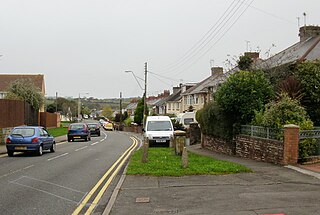
Aberkenfig is a village located in the County Borough of Bridgend, Wales to the north of Bridgend town. It is in the community of Newcastle Higher.
Sarn is a village in Bridgend County Borough, Wales, about three miles north of Bridgend and which lies just east of the confluence of the Ogmore and Llynfi rivers. It is located to the east of Aberkenfig, south of Brynmenyn, and south-east of Tondu. It is around 15 minutes' walk from the M4 and the McArthurGlen Group Bridgend Designer Outlet.

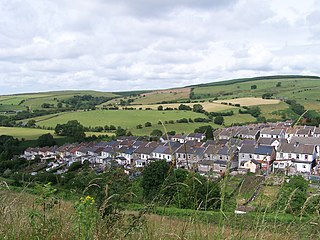
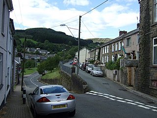
Ogmore Vale is a village in the county borough of Bridgend, Wales on the River Ogmore. The village's main source of income came from coal mining. Up until the year 1865, the Ogmore valley was a quiet, isolated, rural hill farming community of less than ten farms and a few cottages. Today, along with Nantymoel and Price Town it makes up the community of Ogmore Valley.
Bettws, is a small ex-mining and farming village in the South Wales Valleys in the county borough of Bridgend, Wales. Bettws is also an electoral ward for the county council.
Gilfach Goch is a community, electoral ward and small former coal mining village mostly in the Borough of Rhondda Cynon Taf, south Wales, near the larger community of Tonyrefail. Some areas in the North Western part of the village lie within Bridgend County Borough. It is situated in the Cwm Ogwr Fach between the Cwm Ogwr Fawr to the west and the Cwm Rhondda to the east.
Nant-y-moel or Nantymoel is a village and includes the formerly separate village of Pricetown in the county borough of Bridgend, Wales on the River Ogmore, and is one of the constituent villages of the Ogmore Valley. It is bordered by the village of Wyndham to the south and by the Bwlch y Clawdd mountain to the north.

Caerau is a former mining village in the community of Maesteg, Bridgend County Borough, Wales, located approximately 2 miles north of the centre of Maesteg town in the Llynfi Valley. Caerau, surrounded by mountainous terrain and forestry, is one of the border points between Bridgend County Borough and Neath Port Talbot County Borough, bordered to the north by Croeserw and Cymmer, Neath Port Talbot. Caerau, borders Dyffryn and Spelter to the south in Nantyffyllon, Maesteg.
Llangeinor is a small village located in the Garw Valley around 5 miles (8 km) north of Bridgend in Bridgend County Borough, Wales. The ward population taken at the 2011 census was 1,243. The entire village is now protected as part of a conservation area.
Brynmenyn is a small village located at the confluence of the Garw and Ogmore rivers in south Wales, around 4 miles north of Bridgend, and it also in the Bridgend County Borough council area. The village has its own primary school.

Garw Valley is a community and coterminous electoral ward in the north of Bridgend County Borough, South Wales. As the name suggests, it follows and encompasses the valley of the River Garw. The community includes the village of Blaengarw at the head of the valley, followed by Pontycymer and Llangeinor on the river, with Bettws between the Garw and the Llynfi in the south. Garw Valley is bordered to the west by Maesteg, Llangynwyd Middle and Llangynwyd Lower; to the east by Ogmore Valley and to the south by Ynysawdre and St Bride's Minor.

Ynysawdre is a small community in Bridgend County Borough, south Wales. It is located to the east of Aberkenfig in Wales, and comprises the two villages of Tondu and Brynmenyn. The name Ynysawdre is also usually used for a small section of Tondu. At the 2001 census, the population of the community was 3,698, reducing to 3,367 at the 2011 Census.

Newcastle is an area and electoral ward of the town of Bridgend, Wales. The area includes the medieval Newcastle Castle. The ward elects councillors to Bridgend Town Council and Bridgend County Borough Council.
Ogmore and Garw Urban District Council was an Urban District in Glamorgan, Wales. It was created in 1894 as a result of the Local Government Act 1894 and the 1894 Ogmore and Garw UDC election saw the election of the first members of the authority. The Council existed until 1973 and replaced the Ogmore and Garw Local Board of Health which had functioned for some years. Its boundaries were set in 1894. Initially, the Council had twelve members but this was increased some years later, as a result of the increase in population. There were two wards, namely Garw Valley and Ogmore Valley.
Litchard is a village and residential district north of Bridgend, Wales. It is also an electoral ward in the Coity Higher community, as well as a former ward to Bridgend County Borough Council.
