
Cleveland State University (CSU) is a public research university in Cleveland, Ohio. It was established in 1964 and opened for classes in 1965 after acquiring the entirety of Fenn College, a private school that had been in operation since 1923. CSU absorbed the Cleveland-Marshall School of Law in 1969. Today it is part of the University System of Ohio, has more than 120,000 alumni, and offers over 200 academic programs amongst eight colleges. It is classified among "R2: Doctoral Universities – High research activity".

U.S. Route 322 is a 494-mile-long (795.0 km), east–west United States Highway, traversing Ohio, Pennsylvania, and New Jersey. The road is a spur of US 22 and one of the original highways from 1926. A portion of it at one time was concurrent with the Lakes-to-Sea Highway.
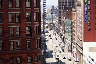
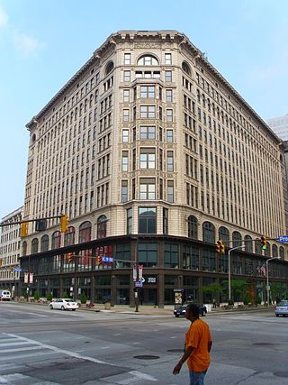
Euclid Avenue is a major street in Cleveland, Ohio, United States. It runs northeasterly from Public Square in Downtown Cleveland, passing Playhouse Square and Cleveland State University, to University Circle, the Cleveland Clinic, Severance Hall, Case Western Reserve University's Maltz Performing Arts Center, Case Western Reserve University and University Hospitals Case Medical Center. The street runs through the suburbs of East Cleveland, Euclid, and Wickliffe, to Willoughby as a part of U.S. Route 20 and U.S. Route 6. The HealthLine bus rapid transit line runs in designated bus lanes in the median of Euclid Avenue from Public Square to Louis Stokes Station at Windermere in East Cleveland.

Playhouse Square is a theater district in downtown Cleveland, Ohio, United States. It is the largest performing arts center in the US outside of New York City. Constructed in a span of 19 months in the early 1920s, the theaters became a major entertainment hub for the city for much of the 20th century. However, by the late 1960s, the district had fallen into decline and its theaters had closed down. In the 1970s, the district was revived through a grassroots effort that helped usher in a new era of downtown revitalization. For this reason, the revival of Playhouse Square is often locally referred to as being "one of the top ten successes in Cleveland history."

The Cleveland Institute of Art, previously Cleveland School of Art, is a private college focused on art and design and located in Cleveland, Ohio.

Downtown Cleveland is the central business district of Cleveland, Ohio, United States. The economic and cultural center of the city and the Cleveland metropolitan area, it is Cleveland's oldest district, with its Public Square laid out by city founder General Moses Cleaveland in 1796.

Cuyahoga Community College (Tri-C) is a public community college in Cuyahoga County, Ohio. Founded in 1963, it is the oldest and largest public community college within the state. Not until 1961 had Ohio permitted the establishment of community colleges and Ohio was then one of only four U.S. states without them.
Columbus, the state capital and Ohio's largest city, has numerous neighborhoods within its city limits. Neighborhood names and boundaries are not officially defined. They may vary or change from time to time due to demographic and economic variables.

The Standard Building,, is a high-rise apartment building located at the southwest corner of Ontario Street and St. Clair Avenue in downtown Cleveland, Ohio. Rising to a height of 282 feet, the Standard Building was the second tallest building in Cleveland when it was completed in 1925. Its north and east facades are clad in cream-colored terra cotta with a recurring starburst motif. The south face, which can be seen from Public Square, is unadorned and windowless. It was designed by Knox and Elliot architects, and was built for $7 million. It was built by the Brotherhood of Locomotive Engineers and Trainmen who owned the building until 2014, when it was sold to Weston, Inc.
The Cuyahoga County Juvenile Detention Center (CCJDC) is a youth detention center located in Cleveland, Ohio. It is accredited by the American Correctional Association Commission on Accreditation for Corrections. Its average daily population in 2007 was 163 residents, a condition which was described as overcrowded.

Hough is a neighborhood situated on the East Side of Cleveland, Ohio. Roughly two square miles, the neighborhood is bounded to Superior and Euclid Avenue between East 55th and East 105th streets. Placed between Downtown Cleveland and University Circle, Hough borders Fairfax and Cedar–Central to the South and Glenville and St. Clair–Superior to the North. The neighborhood became a target for revitalization during the mid-20th century, after the 1966 Hough Riots.
Central, also known as Cedar–Central, is a neighborhood on the East Side of Cleveland, Ohio. Situated on the outskirts of downtown, Central is bounded roughly by East 71st Street on its east and Interstate 90 on its west, with Euclid Avenue on its north and Interstate 77 and the Penn Central Railroad to the south. The neighborhood is eponymously named for its onetime main thoroughfare, Central Avenue. It is home to several schools, including East Technical High School.
Asiatown, also spelled AsiaTown and formerly known as Chinatown, is a Chinatown located in Cleveland, Ohio, in the United States. Chinese people, brought to the country as railroad workers, established the area in the 1860s. The area became known as Chinatown in the 1920s, and was then centered at Rockwell Avenue and E. 22nd Street. Large numbers of non-Chinese people from Asia settled in the area in the 1960s and 1970s, leading to the enclave's expansion eastward. The expanded enclave was named Asiatown in 2006, with that portion on Rockwell Avenue often being referred to as "Old Chinatown" or "Historic Chinatown".
East 4th Street is a major pedestrian zone in Downtown Cleveland, Ohio, known for its food, entertainment, and nightlife. The street runs south from Euclid Avenue to Prospect Avenue. Once a very run down street, the area has been renovated and revitalized by the establishment of numerous restaurants, bars, nightclubs, and apartments, turning it into one of the main nightlife hotspots in the city.

The Nine-Twelve District is a major area of downtown Cleveland, in the U.S. state of Ohio, that is the re-branding of the former Financial District of Cleveland. This re-branding has largely been championed by the Downtown Cleveland Alliance. The name refers to the two major commercial avenues between which the district lies, East 9th Street and East 12th Street, with Lakeside Avenue and Euclid Avenue serving as the northern and southern boundaries, respectively. This revamping and reboot of the Cleveland Central Business District has occurred because property and business owners demanded more investment in the central area. The district is home to the newly expanded Cuyahoga County Headquarters.
The Rose Building is a 1902-built historic high-rise office building in Downtown Cleveland's Gateway District in the U.S. state of Ohio that stands 165 feet tall, 10 stories on the corner of Prospect Avenue and East Ninth Street at the very cusp of the city's Nine-Twelve District. It is named after Cleveland businessman and charity founder Benjamin Rose. It is a designated city of Cleveland landmark. The building was the home of the Cleveland-based health insurance group Medical Mutual of Ohio up until 2023.

Superior Avenue is the main wide thoroughfare and part of U.S. Route 6 in Ohio in Downtown Cleveland, the largest and most populated city of Northeast Ohio. Superior runs through the central hub of Cleveland, Public Square. However, the only traffic that can go through the square is bus, bike, and pedestrian transportation. In 2016, the city of Cleveland completed renovation of the Public Square green space and it was decided that no civilian vehicular traffic should be allowed to traverse the park area. Public Square is the "hub" because all of the main streets in downtown jut out from this central greenery. To the east and west, Superior, to the north and south Ontario Street as all the north–south roads are Streets in Cleveland (which goes back to the 1906 Street Plan Decision, and diagonally to the southwest, Euclid Avenue.
Goodrich–Kirtland Park is a neighborhood on the East Side of Cleveland, Ohio. Roughly bounded between Euclid Avenue to the south, E. 55th Street to the east, I-90 to the west, and Lake Erie and Burke Lakefront Airport to the north.

Lombard Street is a main thoroughfare in Portland, Oregon, United States. It serves as a boundary and main commercial street for several north Portland neighborhoods.

The transportation system of Cleveland is a network that includes several modes of transportation including sidewalks, roads, public transit, bicycle paths and regional and international airports.


