West Park, Cleveland

Last updated
Map of the West Park historical area, comprising the neighborhoods of Jefferson, Kamm's Corners, Bellaire-Puritas, and Hopkins. Cleveland City Neighborhoods - Historical Area - West Park.png
Map of the West Park historical area, comprising the neighborhoods of Jefferson, Kamm's Corners, Bellaire–Puritas, and Hopkins.

West Park is a historical area on the West Side of Cleveland, Ohio. Once an independent municipality, it was annexed by Cleveland after a referendum in 1923. [1] The area covers 12.5 square miles and is bounded by West 117th Street to the east, the Rocky River Valley to the west, Brookpark Road to the South, and the streetcar suburb of Lakewood to the north. The Cleveland City Planning Commission traditionally divides West Park into four neighborhoods: Jefferson, Kamm's Corners, Bellaire–Puritas, and Hopkins. [2]

Contents

History

Cleveland Public Library - West Park Branch WEST PARK LIBRARY.jpg
Cleveland Public Library – West Park Branch

Up until the 1600s, the area of West Park had no name. West Park was part of the vast, forest-covered wilderness that once blanketed most of the eastern half of the present United States and it followed the pattern of settlement from Native American civilizations to migration from eastern colonists. [3] In 1796, the Connecticut Land Company sent an expedition, led by General Moses Cleaveland, to explore and survey their new holdings in the Connecticut Western Reserve. Cleaveland landed at the mouth of the Cuyahoga River in July and founded Cleveland, Ohio. [4]

Rockport Township

In 1810 Cuyahoga County was formally organized with Cleveland as the county seat. At this time the site of future West Park, seven miles west of Cleveland, was in a region officially known only as Township 7, Range 14 of the Western Reserve. [5] In 1812, Nathan Alger, with his wife and sons, Henry, Herman, Nathan Jr., and Thaddeus P., and his son-in-law, John Kidney, all from Litchfield County, Connecticut, settled upon sections twelve and thirteen in the township and founded Alger settlement. [6] Two days later, Benjamin Robinson, afterward son-in-law of Nathan Alger, came from Vermont and also settled in that area. [7] Nathan Alger Sr. died January 21, 1813, the first white person who died in the township. [8]

In 1819, the eighteen families living in the area decided to adopt a more proper name than just being referred to as Township 7, Range 14. They chose "Rockport Township," inspired by the high rocky embankments along the lake and both sides of Rocky River. [9] Using present-day landmarks, it was bounded by Lake Erie on the north, West 117th on the east, Brookpark Road on the south and West 230th, in the present City of Fairview Park on the west. As the population of the 15,207-acre township grew, hamlets and villages were formed, eventually leading to the establishment of surrounding Lakewood, Rocky River and Fairview Village (Fairview Park). [10]

In 1892, Rockport Hamlet (future West Park) was formed within Rockport Township, bounded by the Rocky River on the west, West 117th street on the east and Brookpark Road on the south. On January 31, 1900, Rockport Hamlet petitioned the county to form its own co-existent township with Rockport Township. [11] On March 7, 1900, the request was granted and a new Township of West Park was created. In 1902 the Rockport Hamlet was incorporated as Rockport Village within West Park Township. Finally, on February 1, 1913, Rockport Village changed its name and became the Village of West Park. In February 1921 it officially became West Park City with a population of 5,000 residents. [12]

Naming of West Park

The name West Park was named after one of its early settlers, John M. West. West was born in 1811 in County Leitrim, Ireland. He immigrated to America with his parents in 1826. In the 1840s he married Frances O'Brien who was born in County Roscommon, Ireland. [13]

In about 1842, John West bought a 600-acre farm in Rockport Township, situated along the south side of Lorain Avenue and extending roughly from present West 137th to West 143rd Streets. [14] As of 2014, the red brick home he built still stands at 3684 West 138th Street. John and Frances West had a family of eight children in the house, raising six of them to adulthood. [15] The West Farm included a 25-acre "front yard" and an artificial lake complete with rowboats. This park-like wooded preserve, located at present West 138th Street and Lorain Avenue, came to be called "West Park." Thus, John M. West is not the founder of West Park nor its first settler, but he did create the estate from which the city of West Park took its name.

City of West Park

West Park existed as a separate municipality for approximately nine years and eight months but during that brief period it was a fully functioning city. It had a two-story brick city hall on Lorain Avenue near West 157th Street which housed the mayor's office, all city departments, and police headquarters. The West Park police department consisted of a chief, two sergeants and 12 officers. The fire department boasted two fire stations, a chief, a captain, three lieutenants, 20 men, and a motorized fire engine. [12] West Park also claimed a well-developed public school system with nine schools, one of them a high school with 300 students (the old John Marshall High School at the corner of W. 152nd and Lorain Avenue) and 2,650 pupils and 94 teachers overall. [16] The city's total property evaluation in 1922 was $27,000,000. [12]

Annexation to Cleveland

In the early 1920s, a campaign began to annex West Park to the city of Cleveland, its immediate neighbor to the east. Miss Carrie Norton, stated, "Annexation is inevitable, and the logical moment has arrived." [12] Cleveland was then the fifth largest city in the country, having annexed many of the smaller communities around it. Over the years, the citizens of Newburgh, South Brooklyn and Collinwood, among others, voted to merge with the City of Cleveland. By 1922, Cleveland wanted to add West Park to the list. The majority of people in West Park liked the idea. Mayor George C. Reitz stated he'd no longer be mayor of West Park, but "I'm going to be a resident of Cleveland." [12] Some of the issues that persuaded West Parkers to want to become a part of the city of Cleveland was Cleveland's promise to lower taxes and public transportation fares, update utilities and infrastructure, as well as offer a better safety force and lower-cost schools. The tax rate in West Park was $2.78 while Cleveland's rate was $2.49. Cleveland pledged to provide West Park with street car service for a $.05 compared to the current fare of $.07 ½ and cut water bills in half. Cleveland also claimed to provide a superior school system for a lower cost per pupil. They also promised better police protection, more paved streets, better lighting, and increased public service. In spite of all the claims, street car service was the main issue in the annexation battle. [12]

The matter came to a vote on November 7, 1922. Annexation won by a vote of 2,011 to 1,077. West Park became Cleveland's new ward 33. The public property and services were taken over by Cleveland, and West Park became a part of Cleveland on January 1, 1923. West Park was the last independent city to be annexed by Cleveland. [1]

West Park in the 21st Century

West Park in the 21st century is more defined as west of W. 130th Street to the Metroparks and the Rocky River Valley. It seems more suburban than urban, with trim brick bungalows and Tudors, and thriving retail areas. There is a collection of mostly Irish-oriented bars and restaurants near Kamm's Corners.

In 2019, the Cleveland Public Library appointed an architectural team to renovate and build an addition on the system’s West Park Branch Library, as part of a 10-year, $100 million plan to update 27 branches throughout the city. The project, funded by a tax increase in 2017, which won by a near 70% margin, should be completed by 2029 when the system will invest an additional $65 million into renovations of the Main Library in downtown Cleveland. [17]

The neighborhood has been the site for the “Hooley,” an outdoor, family-oriented party that features Irish dance, music, food and drink. Celebrating its 10th Anniversary in 2019, the Hooley (Irish for a “lively gathering”) is traditionally opened either by the Cleveland Police Pipe and Drums or the Cleveland Firefighters Memorial Pipe and Drums. Local politicians, jazz and rock bands, and children's programs complete the day. [18]

West Park also celebrates the annual Greek Festival, a three-day event with live Greek music, dancing and Greek food, served in tents set up in the neighborhood. Sponsored by the George Varouh Cretan Club of Cleveland, the clubhouse is also available to event-goers. [19]

Related Research Articles

<span class="mw-page-title-main">Cuyahoga County, Ohio</span> County in Ohio, United States

Cuyahoga County is a large urban county located in the northeastern part of the U.S. state of Ohio. The county seat and largest city is Cleveland. As of the 2020 census, its population was 1,264,817, making it the second-most populous county in the state.

<span class="mw-page-title-main">Fairview Park, Ohio</span> City in Ohio, United States

Fairview Park is a city in Cuyahoga County, Ohio, United States. The population was 17,291 at the 2020 census. A suburb of Cleveland, it is a part of the Cleveland metropolitan area.

<span class="mw-page-title-main">Lakewood, Ohio</span> City in Ohio, United States

Lakewood is a city in Cuyahoga County, Ohio, United States, on the southern shore of Lake Erie. Established in 1889, it is one of Cleveland's historical streetcar suburbs and part of the Cleveland metropolitan area. The population was 50,942 at the 2020 census, making it the third largest city in Cuyahoga County, behind Cleveland and Parma.

<span class="mw-page-title-main">Greater Cleveland</span> Metropolitan area in Ohio, United States

The Cleveland metropolitan area, or Greater Cleveland as it is more commonly known, is the metropolitan area surrounding the city of Cleveland in Northeast Ohio, United States. According to the 2020 census results, the six-county Cleveland, OH Metropolitan Statistical Area (MSA) consists of Cuyahoga County, Ashtabula County, Geauga County, Lake County, Lorain County, and Medina County, and has a population of 2,185,825, making it the 33rd-most populous metropolitan area in the United States and the third largest metropolitan area in Ohio. The metro area is also part of the larger Cleveland–Akron–Canton Combined Statistical Area with a population of over 3.7 million people, the most populous statistical area in Ohio and the 17th most populous in the United States.

<span class="mw-page-title-main">Rocky River (Ohio)</span> River in United States of America

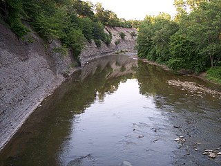
The Rocky River is a relatively short river in Cuyahoga County, Ohio that forms the natural western boundaries of Cleveland and the suburb of Lakewood with the suburbs of Fairview Park and Rocky River. The latter community is named after the river. To the south of Fairview Park and west of Cleveland Hopkins International Airport, the river forms the natural boundary between the suburb of Brook Park and the communities of North Olmsted and Olmsted Township. Ranked by Field & Stream as one of the top steelhead trout rivers in the world, the Rocky River is the center of the Rocky River Reservation of the Cleveland Metroparks.

<span class="mw-page-title-main">The Flats</span> Historic district in Cleveland, Ohio

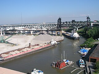
The Flats is a mixed-use industrial, recreational, entertainment, and residential area of the Cuyahoga Valley neighborhood of Cleveland, Ohio, U.S. The name reflects its low-lying topography on the banks of the Cuyahoga River.

<span class="mw-page-title-main">Old Brooklyn</span> Neighborhood of Cleveland, Ohio, United States

Old Brooklyn is a neighborhood on the West Side of Cleveland, Ohio, United States, located approximately five miles south of downtown Cleveland. It extends east-to-west from the Cuyahoga River to the city of Brooklyn and north-to-south from the Brookside Park Valley to the city of Parma. It is home to the Cleveland Metroparks, including the Cleveland Zoo; the Jesse Owens tree at James Ford Rhodes High School; and the Benjamin Franklin Community Garden, the largest urban community garden in Cuyahoga County. Old Brooklyn has recently adopted the slogan "Old Brooklyn, a great place to grow" to commemorate its history and potential growth.

<span class="mw-page-title-main">Ohio City, Cleveland</span> Neighborhood of Cleveland, Ohio, United States

Ohio City is one of the oldest neighborhoods in Cleveland, Ohio. It is located immediately west of the Cuyahoga River.

Sun Newspapers was formed as a chain of weekly newspapers serving Northeast Ohio. Prior to a major reorganization in 2013, the chain consisted of 11 weekly newspapers serving 49 different communities in Greater Cleveland. The papers are focused on suburbs and exurbs in Cuyahoga, Geauga, Lorain and Medina counties. Its offices are in Valley View.

<span class="mw-page-title-main">Kamm's Corners</span> Neighborhood of Cleveland, Ohio, United States

Kamm's Corners is a neighborhood on the West Side of Cleveland, Ohio. It is bounded by the streetcar suburb of Lakewood to the north, the Rocky River Reservation of the Cleveland Metroparks and the suburbs of Rocky River and Fairview Park to the west, the New York Central Railroad tracks to the east, and Puritas Road to the south. Kamm's Corners Plaza and Warren Village are the major retail centers of the neighborhood. According to the 2019 U.S. census estimate, the neighborhood has the highest concentration of Irish Americans in Cleveland and Cuyahoga County.

<span class="mw-page-title-main">Columbia Township, Lorain County, Ohio</span> Township in Ohio, United States

Columbia Township, also known as Columbia Station or just Columbia, is the easternmost of the eighteen townships of Lorain County, Ohio, United States. Columbia Township is the official government name, while Columbia Station is the post office name, and tends to be the town name used by residents. The post office name was chosen to differentiate the township from other Columbia Townships statewide, located in Hamilton and Meigs counties.

<span class="mw-page-title-main">Olmsted Township, Cuyahoga County, Ohio</span> Township in Ohio, United States

Olmsted Township is a township located in Cuyahoga County, Ohio, United States. Situated in the southwest end of the county, Olmsted Township is a west side suburb of Cleveland, and a part of the even larger Greater Cleveland area. As of the 2020 Census, Olmsted Township had a population of 14,506. It is one of only two civil townships remaining in Cuyahoga County, and the only Olmsted Township statewide.

<span class="mw-page-title-main">Defunct townships of Cuyahoga County, Ohio</span>

Cuyahoga County, Ohio, United States is divided into 21 townships.

<span class="mw-page-title-main">Detroit–Shoreway</span> Neighborhood of Cleveland, Ohio, United States

Detroit–Shoreway is a neighborhood on the West Side of Cleveland, in the U.S. state of Ohio. Detroit–Shoreway consists of the streets between Lake Erie and Interstate 90, from West 85th to West 45th streets.

<span class="mw-page-title-main">MetroHealth</span> Hospital in Ohio, USA

The MetroHealth System is a nationally ranked non-profit, public health care system located in Cleveland, Ohio. Founded in 1837 as City Hospital, The MetroHealth System serves the residents of the city of Cleveland and Cuyahoga County. It is one of the three major health care systems in Cleveland, Ohio, along with Cleveland Clinic and University Hospitals of Cleveland.

<span class="mw-page-title-main">Jefferson, Cleveland</span> Neighborhood of Cleveland, Ohio, United States

Jefferson is a neighborhood on the West Side of Cleveland, Ohio. It is bounded by the neighborhoods of West Boulevard and Cudell and the village of Linndale to the east, Bellaire–Puritas to the south, Kamm's Corners to the west, and the streetcar suburb of Lakewood to the north. It is one of four sub-neighborhoods that comprise the larger historical neighborhood of West Park, the others being Kamm's Corners, Bellaire–Puritas, and Hopkins.

<span class="mw-page-title-main">U.S. Route 6 in Ohio</span>

U.S. Route 6 (US 6) is a part of the United States Numbered Highway System that runs from Bishop, California, to Provincetown, Massachusetts. In Ohio, the road runs west–east from the Indiana state line near Edgerton to the Pennsylvania state line near Andover. The 248.002 miles (399.121 km) that lie in Ohio are maintained by the Ohio Department of Transportation (ODOT). US 6 serves the major cities of Sandusky, Lorain, and Cleveland. The highway is also called the Grand Army of the Republic Highway to honor the Union forces of the U.S. Civil War. The alternate name was designated in 1953.

<span class="mw-page-title-main">Demographics of Cleveland</span>

The demographics of Cleveland have fluctuated throughout the city's history. From its founding in 1796, the city's population grew to 261,353 by 1890, and to 796,841 by 1920, making it the fifth largest city in the United States at the time. By 1930, the population rose to 900,429 and, after World War II, it reached 914,808. Due to various historical factors including deindustrialization, suburbanization, and urban sprawl, Cleveland's population began decreasing in the 1960s. By 1970, the city's population was 750,903. By 1980, it was 573,822 and it had lost its position as one of the top 10 largest cities in the U.S. By 2020, the population had further fallen to 372,624. Beginning in 2018, the city's population began to flatten, after decades of decline. Additionally, between 2010 and 2020, several neighborhoods within Cleveland saw a significant population increase, most notably Downtown, but also University Circle and several West Side neighborhoods.

<span class="mw-page-title-main">Bellaire–Puritas, Cleveland</span> Neighborhood of Cleveland, Ohio, United States

Bellaire–Puritas is a neighborhood on the West Side of Cleveland, Ohio, in the United States. Originally part of the Village of West Park, it was annexed by the city in 1923. Formerly known as Puritas–Longmead, the neighborhood takes its name from the two streets which form its northern boundary: Puritas Avenue and Bellaire Road.

<span class="mw-page-title-main">Hopkins, Cleveland</span> Neighborhood of Cleveland, Ohio, United States

Hopkins is a neighborhood on the West Side of Cleveland, Ohio. Known as Riverside until 2014, it borders the neighborhoods of Kamm's Corners and Bellaire–Puritas to the north and northeast, the suburb of Fairview Park to the northwest, and Brook Park to the south, east, and west. Most of the area of Hopkins is covered by Cleveland Hopkins International Airport. Consequently, the neighborhood has "one of Cleveland's lowest population levels as well as the lowest level of population density."

References

  1. 1 2 "West Park". The Encyclopedia of Cleveland History. Case Western Reserve University. Retrieved December 14, 2012.
  2. Until 2014, Bellaire–Puritas and Hopkins were known as Puritas–Longmead and Riverside respectively. "Statistical Planning Area Map (Neighborhoods)". Neighborhood Link. Retrieved April 19, 2015. "City Planning Commission". Zoning Layer. Retrieved April 22, 2015.
  3. A History of Ohio, Eugene H. Roseboom and Francis P. Weisenburger, (Columbus: The Ohio State Archaeological and Historical Society, 1953).
  4. "Moses Cleaveland". Ohio History Central. Retrieved October 12, 2014.
  5. Anthony J. Iezzi, History of Rockport Township and The City of Fairview Park From Its Origins to 1923, (Fairview Park: Saint Angela Merici Parish, 1999), 3.
  6. History of Cuyahoga County, Ohio; Part Third: The Townships, compiled by Crisfield Johnson, (D. W. Ensign & Co., 1879), 502, accessed on October 12, 2014. https://archive.org/stream/cu31924010461790/cu31924010461790_djvu.txt
  7. "Alger, Nathan," Early Settlers and Their Legacies, History of the West Park Neighborhood, Cleveland, Cuyahoga County, Ohio, last modified June 17, 2004. http://www.westparkhistory.com/history/settlers.htm
  8. "Alger, Henry." The Encyclopedia of Cleveland History, last modified July 10, 1997, http://ech.case.edu/cgi/article.pl?id=AH5
  9. Anthony J. Iezzi, History of Rockport Township and The City of Fairview Park From Its Origins to 1923, (Fairview Park: Saint Angela Merici Parish, 1999), 3–4.
  10. "Rockport", The Encyclopedia of Cleveland History, last modified July 22, 1997, http://ech.case.edu/cgi/article.pl?id=R4
  11. Anthony J. Iezzi, History of Rockport Township and The City of Fairview Park From Its Origins to 1923, (Fairview Park: Saint Angela Merici Parish, 1999), 4.
  12. 1 2 3 4 5 6 "Howdy, Miss West Park!" Says Uncle Mose. Cleveland Welcomes Healthy Baby Into Family.' Cleveland Press. November 11, 1922. The dates for these events will sometimes differ among various authors or sources, depending on whether the date elected is for the original citizen petition, or the official approval and designation by the County Commissioners, or the first formal meeting of their Council.
  13. "West, John M.", Early Settlers and Their Legacies, History of the West Park Neighborhood, Cleveland, Cuyahoga County, Ohio, last modified June 17, 2004. http://www.westparkhistory.com/history/settlers.htm
  14. Gary Swilik, "Meet the REAL Founder of West Park!http://www.westparkhistory.com/history/realwest.htm last modified August 7, 2013.
  15. Some sources incorrectly claim West Park was named for "Benjamin West". An early researcher got it wrong years ago and the error has been repeated ever since. For example, see Iezzi, History of Rockport Township and The City of Fairview Park From Its Origins to 192, 6.
  16. Detroit Board of Education, The Detroit Educational Bulletin (Detroit, MI., 1922), 27.
  17. Litt, Steven (29 August 2019). "Cleveland Public Library picks design teams for first 5 projects in $100 million plan to improve 27 branches". The Plain Dealer. Cleveland: Advance Ohio Inc.
  18. Kovach, Carol (8 May 2018). "The Hooley Returns". cleveland.com. Cleveland, Ohio: AdvanceOhio. Retrieved 23 April 2019.
  19. Kovach, Carol (28 August 2018). "Kamms Corners offers Greek Festival". cleveland.com. Cleveland, Ohio: AdvanceOhio. Retrieved 23 April 2019.