Quidenham is a small rural village and civil parish in the English county of Norfolk. It covers an area of 22.51 km2 (8.69 sq mi) and had a population of 576 in 183 households at the 2001 census, falling to a population of 560 living in 189 households at the 2011 Census. For the purposes of local government, it falls within the district of Breckland.

Ashby with Scremby is a civil parish in the East Lindsey district of Lincolnshire, England, with a population of 147, increasing to 179 at the 2011 census. The parish includes the village of Scremby, along with the hamlets of Ashby by Partney and Grebby.
Bubwith is a village and civil parish in the East Riding of Yorkshire, England. The village is situated about 6 miles (10 km) north-east of Selby, and 7 miles (11 km) north of Goole. It is situated on the east bank of the River Derwent, west of which is the Selby district of North Yorkshire. It lies on the A163 road.

Broomhall Green is a village in the civil parish of Broomhall in the unitary authority of Cheshire East and the ceremonial county of Cheshire, England. The parish includes part of the settlement of Sandford. According to the 2001 Census the parish had a population of 206, decreasing marginally to 204 at the 2011 Census. The village is about 3½ miles south-west of Nantwich, on the A530 road.

Wood Dalling is a village and civil parish in the English county of Norfolk. It is situated some 20 kilometres (12 mi) east of Fakenham, 20 km (12 mi) south-west of Cromer, and 30 km (19 mi) north-west of Norwich.

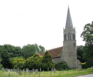
Witton is a village and civil parish in the English county of Norfolk. It is located 8 km (5.0 mi) east of the town of North Walsham and 30 km (19 mi) north of the city of Norwich. It should not be confused with the quite different Norfolk village of similar name in the parish of Postwick with Witton, some 8 km (5.0 mi) east of Norwich.

South Witham is a village and civil parish in the South Kesteven district of Lincolnshire, England. The population of the civil parish at the 2011 census was 1,533. It is situated 10 miles (16 km) south of Grantham and 10 miles east of Melton Mowbray. The village is close to the Leicestershire and Rutland borders.

Snetterton is a village and civil parish in the English county of Norfolk. The village is located some 20 km (12 mi) north-east of the town of Thetford and 30 km (19 mi) south-west of the city of Norwich.

Norbury is a civil parish in the unitary authority of Cheshire East and the ceremonial county of Cheshire. According to the 2001 census, the parish had a population of 190, increasing slightly to 194 at the 2011 Census.

Hatherton is a hamlet and civil parish in the unitary authority of Cheshire East and the ceremonial county of Cheshire, England. The hamlet is located 2¾ miles to the north east of Audlem and 3¾ miles to the south east of Nantwich. The parish also includes the small settlements of Birchall Moss, Broomlands and part of Artlebrook. Nearby villages include Hankelow, Stapeley, Walgherton and Wybunbury. According to the 2001 Census, Hatherton civil parish had a population of 344, increasing to 360 at the 2011 Census.

Gunby is a hamlet in the South Kesteven district of Lincolnshire, England. It is situated close to the borders with Leicestershire and Rutland, and 9 miles (14 km) south from Grantham, and 2 miles (3 km) west from the A1 road. It is in the civil parish of Gunby and Stainby.Its most notable citizen is John Wearing
Stainby is a hamlet in the South Kesteven district of Lincolnshire, England. It is situated 2 miles (3.2 km) west from the A1 road, 1.5 miles (2.4 km) east from the Viking Way and the Leicestershire border, and 8 miles (13 km) south from Grantham.

Great Humby is a hamlet in the South Kesteven district of Lincolnshire, England. It lies in the civil parish of Ropsley and Humby, 6 miles (9.7 km) east from Grantham, 1.5 miles (2.4 km) south-east from Ropsley and 3 miles (4.8 km) south from the A52. Little Humby, a larger hamlet, is 720 yards (658.4 m) to the north. It is in the civil parish of Ropsley and Humby.

Shipdham is a village and civil parish in the Breckland district, in Norfolk, England, approximately 5 miles (8.0 km) south-south-west of Dereham. In the 2001 census the parish had a population of 2,145 in 899 households, falling at the 2011 Census to a population of 2,057 in 891 households. It covers an area of 18.69 km2 (7.22 sq mi). It is also known to be the longest village in Norfolk.
Hankelow is a village and civil parish in the unitary authority of Cheshire East and the ceremonial county of Cheshire, England. It used to be a township within the township of Audlem, one mile away on the Nantwich Road. According to the 2001 Census, the parish had a population of 272, reducing to 261 at the 2011 Census. Hankelow was formerly part of the Crewe and Nantwich parliamentary constituency. Following a parliamentary boundary review in 2008, the village transferred to the Eddisbury parliamentary constituency upon the dissolution of parliament.
Welton le Marsh is a village and civil parish in the East Lindsey district of Lincolnshire, England. It is situated approximately 6 miles (10 km) north-east from the town of Spilsby and approximately 5 miles (8.0 km) south from the town of Alford. The hamlet of Boothby lies within the parish about 1 mile (1.6 km) east of Welton le Marsh village.
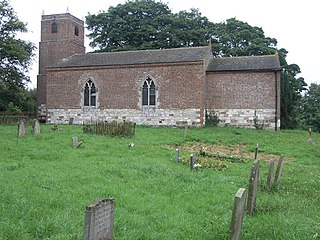
Candlesby is a village in the East Lindsey district of Lincolnshire, England. It is part of the civil parish of Candlesby with Gunby, and situated 5 miles (8 km) east from Spilsby. Gunby is a hamlet about 1 mile (1.6 km) east from Candlesby.

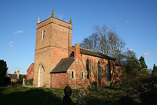
Great Steeping is a village and civil parish in the East Lindsey district of Lincolnshire, England. It is situated approximately 3 miles (5 km) from Spilsby, The parish includes the hamlet of Monksthorpe.
Gayton le Marsh is a village and civil parish in the East Lindsey district of Lincolnshire, England It is situated 6 miles (9.7 km) south-east from the town of Louth and about 6 miles (9.7 km) north from Alford. The population of the civil parish was 155 at the 2011 census.

Gunby and Stainby is a civil parish in the South Kesteven district of Lincolnshire, England. According to the 2001 Census it had a population of 141, falling to 136 at the 2011 census. It includes the hamlets of Gunby and Stainby.