
North East Lincolnshire is a unitary authority area with borough status in Lincolnshire, England. It borders the borough of North Lincolnshire and districts of West Lindsey and East Lindsey. The population of the district in the 2011 Census was 159,616. The administrative centre and largest settlement is Grimsby and the borough includes the towns of Cleethorpes and Immingham as well as the villages of New Waltham, Waltham, Humberston, Healing and Great Coates. The borough is also home to the Port of Grimsby and Port of Immingham as well as Cleethorpes beach.

Cleethorpes is a seaside town on the estuary of the Humber in North East Lincolnshire, England with a population of 38,372 in 2020. It has been permanently occupied since the 6th century, with fishing as its original industry, then developing into a resort in the 19th century. Before becoming a unified town, Cleethorpes was made up of the three small villages of Itterby, Oole and Thrunscoe.

North Thoresby is a village and civil parish in the East Lindsey district of Lincolnshire, England. It is situated between Louth and Grimsby, approximately 7.5 miles (12 km) from each. and has a village population of 1,068 (2011) Some 50.5% of the population is older than 60 years.

Grimsby or Great Grimsby is a port town and the administrative centre of North East Lincolnshire, Lincolnshire, England. Grimsby adjoins the town of Cleethorpes directly to the south-east forming a conurbation. Grimsby is 45 mi (72 km) north-east of Lincoln, 33 mi (53 km) south-south-east of Hull, 28 mi (45 km) south-east of Scunthorpe, 50 mi (80 km) east of Doncaster and 80 mi (130 km) south-east of Leeds. In 2021 it had a population of 86,138.
Market Rasen is a market town and civil parish within the West Lindsey district of Lincolnshire, England. The River Rase runs through it east to west, approximately 13 miles (21 km) north-east from Lincoln, 18 miles (29 km) east from Gainsborough, 14 miles (23 km) west of Louth, and 16 miles (26 km) south-west from Grimsby. It lies on the main road between Lincoln and Grimsby, the A46, and is famous for its racecourse. In 2001, the town had a population of 3,200. In the 2011 census, the population of the civil parish was 3,904.

Caistor is a town and civil parish in the West Lindsey district of Lincolnshire, England. As its name implies, it was originally a Roman castrum or fortress. It lies at the north-west edge of the Lincolnshire Wolds, on the Viking Way, and just off the A46 between Lincoln and Grimsby, at the A46, A1084, A1173 and B1225 junction. It has a population of 2,601. Its name comes from the Anglo-Saxon ceaster and was given in the Domesday Book as Castre.

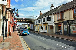
Immingham is a town and civil parish in North East Lincolnshire, in Lincolnshire, England. It is situated on the south-west bank of the Humber Estuary, and is 6 miles (10 km) north-west from Grimsby.

Alvingham is a village and civil parish in the East Lindsey district of Lincolnshire, England. It is situated 3 miles (5 km) north-east from the market town of Louth.

Waltham is a large village and civil parish in North East Lincolnshire, England. It is 4 miles (6 km) south of Grimsby close to the suburb of Scartho and to the smaller villages of Brigsley, Barnoldby-le-Beck, and Holton le Clay. Less than 2 miles (3 km) to the east-north-east is the village of New Waltham. In the 2001 census, Waltham had a population of 6,420, reducing slightly to 6,413 at the 2011 census.

Bradley is a village and civil parish in North East Lincolnshire, England. It is situated approximately 3 miles (5 km) south-west from Grimsby and 2 miles (3 km) north from Barnoldby le Beck. Its population recorded in the census for both 2001 and 2011 was 198.

Grimsby Rural District was a rural district in Lincolnshire, England, part of the administrative county of Lindsey, from 1894 to 1974.

Bilsby is a village and civil parish in the East Lindsey district of Lincolnshire, England. It lies on the main A1111 road between Alford and Sutton-on-Sea, 1 mile (1.6 km) east of Alford. Thurlby and Asserby are hamlets within Bilsby parish. The censuses showed a parish population of 538 in 2001 and 487 in 2011, with an estimate of 489 in 2019.

Tetney is a village in the East Lindsey district of Lincolnshire, England, just west of the Prime Meridian.

Holton-le-Clay is a village and civil parish in the East Lindsey district of Lincolnshire, England, around 5 miles (8.0 km) south of Grimsby.
Fulstow is a marsh village and civil parish in the East Lindsey district of Lincolnshire, England. It is situated 6 miles (10 km) north of Louth and 8 miles (13 km) south of Grimsby.

Marshchapel is a coastal village and civil parish in the East Lindsey district of Lincolnshire, England. It is approximately 11 miles (18 km) south-east from Grimsby and 13 miles (21 km) north-east from Louth. It includes the hamlets of West End and Eskham.

Grainsby is a hamlet and civil parish in the East Lindsey district of Lincolnshire, England. It is situated 5 miles (8 km) south from Grimsby, and just to the west from the A16 road. The nearest village is North Thoresby, 1 mile (1.6 km) to the south-east.

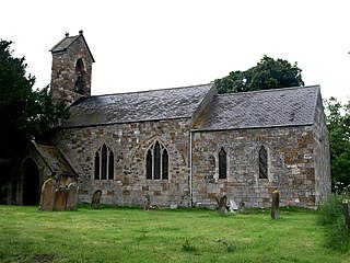
Brackenborough is a hamlet in the civil parish of Brackenborough with Little Grimsby, in the East Lindsey district of Lincolnshire, England. At the census 2011 the population was included in the civil parish of Keddington. It is situated approximately 2 miles (3 km) north from the town of Louth, and lies in the Lincolnshire Wolds, a designated Area of Outstanding Natural Beauty.

