The history of the Falkland Islands goes back at least five hundred years, with active exploration and colonisation only taking place in the 18th century. Nonetheless, the Falkland Islands have been a matter of controversy, as they have been claimed by the French, British, Spaniards and Argentines at various points.

The Falkland Islands are located in the South Atlantic Ocean between 51°S and 53°S on a projection of the Patagonian Shelf, part of the South American continental shelf. In ancient geological time this shelf was part of Gondwana, and around 400 million years ago split from what is now Africa and drifted westwards from it. Today the islands are subjected to the Roaring Forties, winds that shape both their geography and climate.

Cape Agulhas is a rocky headland in Western Cape, South Africa. It is the geographic southern tip of Africa and the beginning of the traditional dividing line between the Atlantic and Indian Oceans according to the International Hydrographic Organization. It is approximately half a degree of latitude, or 55 kilometres (34 mi), further south than the Cape of Good Hope.
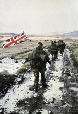
Yomp is Royal Marines slang describing a long-distance loaded march carrying full kit. It was popularised by journalistic coverage in 1982 during the Falklands War. The origin of the word is unclear, and there is no evidence to suggest that it derives originally from an acronym. Various backronymic definitions have however been proposed, including "young officers marching pace", "your own marching pace" and a connection with the term yump used in rally-driving in the sense of "to leave the ground when taking a crest at speed", apparently a Scandinavian pronunciation of jump.
HMS Alacrity was a Type 21 frigate of the Royal Navy.

Cape Henlopen is the southern cape of the Delaware Bay along the Atlantic coast of the United States. It lies in the state of Delaware, near the town of Lewes, where the Delaware Bay meets the Atlantic Ocean. Off the coast on the bay side are two lighthouses, called the Harbor of Refuge Light and the Delaware Breakwater East End Light.

Atlantic Conveyor was a British merchant navy ship, registered in Liverpool, that was requisitioned during the Falklands War.

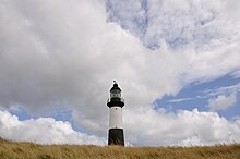
Pebble Island is one of the Falkland Islands, situated north of West Falkland. It is possibly named after the peculiarly spherical pebbles found at its western tip.

Cape Race is a point of land located at the southeastern tip of the Avalon Peninsula on the island of Newfoundland, in Newfoundland and Labrador, Canada. Its name is thought to come from the original Portuguese name for this cape, "Raso", meaning flat or low-lying. The Cape appeared on early sixteenth century maps as Cabo Raso and its name may derive from a cape of the same name at the mouth of the Tagus River in Portugal. The cape was the location of the Cape Race LORAN-C transmitter until the system was decommissioned in 2010. It is also home to the Cape Race Lighthouse, notable for having received the distress call from the RMS Titanic.

The T2 tanker, or T2, was a class of oil tanker constructed and produced in large numbers in the United States during World War II. Only the T3 tankers were larger "navy oilers" of the period. Some 533 T2s were built between 1940 and the end of 1945. They were used to transport fuel oil, diesel fuel, gasoline and sometimes black oil-crude oil. Post war many T2s remained in use; like other hastily built World War II ships pressed into peacetime service, there were safety concerns. As was found during the war, the United States Coast Guard Marine Board of Investigation in 1952 stated that in cold weather the ships were prone to metal fatigue cracking, so were "belted" with steel straps. This occurred after two T2s, Pendleton and Fort Mercer, split in two off Cape Cod within hours of each other. Pendleton's sinking is memorialized in the 2016 film The Finest Hours. Engineering inquiries into the problem suggested the cause was poor welding techniques. It was found the steel was not well suited for the new wartime welding construction. The high sulfur content made the steel brittle and prone to metal fatigue at lower temperatures.

Cape Sōya is the northernmost point of the island of Hokkaidō, Japan and by extension the whole of Japan. It is situated in Wakkanai, Sōya Subprefecture. The Monument of the Northernmost Point of Japan (日本最北端の地の碑) is at the cape, although the true northernmost point under Japanese control is a small deserted island called Bentenjima, 1 kilometre (3,300 ft) northwest. Since the cape is just 43 kilometres (27 mi) away across La Perouse Strait from Cape Crillon, Sakhalin Island, it is possible to catch a glimpse of the island of Sakhalin on a clear day.

The Cape St. George Light is a 72-foot (22 m) high brick lighthouse which had originally stood for 153 years on St. George Island, Florida, until toppling into the Gulf of Mexico October 22, 2005. The pieces of the lighthouse were retrieved, and in April 2008, the light's restoration was completed.
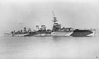
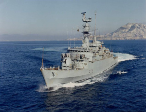
HMS Danae was the lead ship of the Danae-class cruisers, serving with the Royal Navy between the world wars and with the Polish Navy during the latter part of World War II as ORP Conrad.

Cape Horn is the southernmost headland of the Tierra del Fuego archipelago of southern Chile, and is located on the small Hornos Island. Although not the most southerly point of South America, Cape Horn marks the northern boundary of the Drake Passage and marks where the Atlantic and Pacific Oceans meet.

Fox Bay is the second largest settlement on West Falkland in the Falkland Islands. It is located on a bay of the same name, and is on the south east coast of the island. It is often divided into Fox Bay East ("FBE") and Fox Bay West ("FBW") making it two settlements: combined, these make the largest settlement on West Falkland, but if separated, Port Howard is the largest. Fox Bay takes its name, like the Warrah River, from the Falkland fox, an animal locally called the warrah and now extinct.
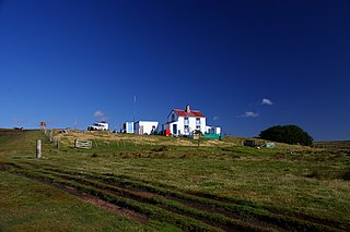
Volunteer Point is a headland on the east coast of East Falkland, in the Falkland Islands, north-northeast of Stanley, and east of Johnson's Harbour and Berkeley Sound. It lies at the end of a narrow peninsula, which protects Volunteer Lagoon. It received its name in 1815, when the sealing ship Volunteer left a boat's crew there to collect seal skins while it went in search of opportunities elsewhere. Four years later, on 13 February 1820, the French research vessel L'Uranie struck a submerged rock just off the point but stayed afloat long enough to be beached in Berkeley Sound. All on board survived, including the Captain's wife, Rose de Freycinet, who recorded the incident in her diary.

The 1982 British military campaign to recapture the Falkland Islands depended on complex logistical arrangements. The logistical difficulties of operating 7,000 nautical miles from home were formidable. The Argentine invasion of the Falkland Islands came at a time when the Royal Navy was experiencing a reduction in its amphibious capability, but it still possessed the aircraft carriers HMS Hermes and Invincible, the landing platform dock (LPD) ships HMS Fearless and Intrepid, and six landing ship logistics (LSL) ships. To provide the necessary logistic support, the Royal Navy's ships were augmented by ships taken up from trade (STUFT).
Cape Carysfort is a headland in the north east of East Falkland between Macbride Head and Volunteer Point. Lochhead Pond is behind it. In 1921 it was the site of the shipwreck of SS Guvernøren, a whale oil tanker which, under its former name SS Imo, had been involved in the massive 1917 explosion that caused severe damage to Halifax, Nova Scotia.

Blue Beach Military Cemetery at San Carlos is a British war cemetery in the Falkland Islands holding the remains of 14 of the 255 British casualties killed during the Falklands War in 1982, and one other killed in early 1984. It is situated close to where 3 Commando Brigade had its initial headquarters after landing on 21 May 1982.