
The history of the Falkland Islands goes back at least five hundred years, with active exploration and colonisation only taking place in the 18th century. Nonetheless, the Falkland Islands have been a matter of controversy, as they have been claimed by the French, British, Spaniards and Argentines at various points.
The Falkland Islands currently has three primary means of transport - road, sea and air. However, in 1946, when Sir Miles Clifford arrived as governor, there were no air services, no roads outside Stanley and an indifferent sea service. Sir Miles was instrumental in starting the Falkland Islands Government Air Service in December 1948. The inaugural flight involved a mercy flight from North Arm Settlement to Stanley to bring a girl with peritonitis to life-saving medical help in Stanley. There is now an international airport, a domestic airport, a number of airstrips, a growing road network and a much-improved ferry service between the two main islands.

East Falkland is the largest island of the Falklands in the South Atlantic, having an area of 6,605 km2 or 54% of the total area of the Falklands. The island consists of two main land masses, of which the more southerly is known as Lafonia; it is joined by a narrow isthmus that was the scene of the Battle of Goose Green during the Falklands War.

Weddell Island is one of the Falkland Islands in the South Atlantic, lying off the southwest extremity of West Falkland. It is situated 1,545 km (960 mi) west-northwest of South Georgia Island, 1,165 km (724 mi) north of Livingston Island, 606 km (377 mi) northeast of Cape Horn, 358 km (222 mi) northeast of Isla de los Estados, and 510 km (320 mi) east of the Atlantic entrance to Magellan Strait.

Carcass Island is the largest of the West Point Island Group of the Falkland Islands.
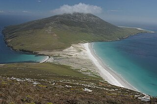
Saunders Island is the fourth largest of the Falkland Islands, lying north west of West Falkland. The island is run as a sheep farm.

Pebble Island is one of the Falkland Islands, situated north of West Falkland. It is possibly named after the peculiarly spherical pebbles found at its western tip.

Sea Lion Island is the largest of the Sea Lion Island Group of the Falkland Islands. It is 9 km2 (3 sq mi) in area. and lies 14 km (9 mi) southeast of Lafonia. It was designated a Ramsar site on 24 September 2001., and as an Important Bird Area. In 2017 the island was designated as a National Nature Reserve.

West Point Island is one of the Falkland Islands, lying in the north-west corner of the archipelago. It has an area of 1,469 hectares (5.67 sq mi) and boasts some of the most spectacular coastal scenery in the Falklands. The island is owned by Roddy & Lily Napier and run as a sheep farm and tourist attraction.

Lafonia is a peninsula forming the southern part of East Falkland, the largest of the Falkland Islands.

Darwin is a settlement in Lafonia on East Falkland, Falkland Islands, lying on Choiseul Sound, on the east side of the island's central isthmus, 2.5 miles (4.0 km) north of Goose Green. It was known occasionally as Port Darwin.

Goose Green is a settlement in Lafonia on East Falkland in the Falkland Islands. It lies on Choiseul Sound, on the east side of the island's central isthmus, 2 miles (3.2 km) south-southwest of Darwin. With a population of about 40, it is the third-largest settlement of the Falkland Islands, after Stanley and Mount Pleasant.

Port Howard is the largest settlement on West Falkland. It is in the east of the island, on an inlet of Falkland Sound. It is on the lower slopes of Mount Maria.

Salvador Settlement, also called Salvador, Salvador Settlement Corral, is a small harbour and settlement on East Falkland, in the Falkland Islands, It is on the north east coast, on the south shore of Port Salvador. It is one of a handful of Spanish place names on the islands, still in use.

The Falkland Islands is an archipelago in the South Atlantic Ocean on the Patagonian Shelf. The principal islands are about 300 miles east of South America's southern Patagonian coast and about 752 miles from the northern tip of the Antarctic Peninsula, at a latitude of about 52°S. The archipelago, with an area of 4,700 square miles, comprises East Falkland, West Falkland, and 776 smaller islands. As a British overseas territory, the Falklands have internal self-governance, and the United Kingdom takes responsibility for their defence and foreign affairs. The capital and largest settlement is Stanley on East Falkland.

Fox Bay is the second largest settlement on West Falkland in the Falkland Islands. It is located on a bay of the same name, and is on the south east coast of the island. It is often divided into Fox Bay East ("FBE") and Fox Bay West ("FBW") making it two settlements: combined, these make the largest settlement on West Falkland, but if separated, Port Howard is the largest. Fox Bay takes its name, like the Warrah River, from the Falkland fox, an animal locally called the warrah and now extinct.
Port Stephens is a settlement and a harbour on West Falkland, in the Falkland Islands. It is on the far southwest of the island, near Calm Head and Cape Meredith and South Harbour is the nearest other settlement. Until recently, it was one of the Falkland Island Company's largest sheep stations. In 1989 the Company split the farm into 5 units which were all bought by former employees. Port Stephens is one of the 5 sections of the original Port Stephens farm and is owned by Peter and Ann Robertson. While the harbour itself is sheltered, the surrounding area is frequently battered by Antarctic storms. The location is highly rugged, and considered to be amongst the most scenic in the Falklands. There is a self-catering cottage at Port Stephens with access to penguin colonies.

Hill Cove is the third largest settlement on West Falkland, in the Falkland Islands, in the north-west. It is on the north coast, on the shore of Byron Sound, and overlooks Port Egmont on Saunders Island, the first British settlement in the islands. Behind the settlement is Mount Adam, which shelters it from southerly winds.
Green Patch is a settlement on East Falkland, in the Falkland Islands, It is on the north east coast, on the south shore of Berkeley Sound, a few miles south east from Port Louis, on Port Louis Harbour. It looks out onto Long Island and Hog Island.

