Related Research Articles
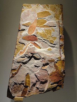
Glossopteris is the largest and best-known genus of the extinct Permian order of seed plants known as Glossopteridales. The genus Glossopteris refers only to leaves, within a framework of form genera used in paleobotany. Species of Glossopteris were the dominant trees of the middle to high-latitude lowland vegetation across the supercontinent Gondwana during the Permian Period. Glossopteris fossils were critical in recognizing former connections between the various fragments of Gondwana: South America, Africa, India, Australia, New Zealand, and Antarctica.

The Hanson Formation is a geologic formation on Mount Kirkpatrick and north Victoria Land, Antarctica. It is one of the two major dinosaur-bearing rock groups found on Antarctica to date; the other is the Snow Hill Island Formation and related formations from the Late Cretaceous of the Antarctic Peninsula. The formation has yielded some Mesozoic specimens, but most of it is as yet unexcavated. Part of the Victoria Group of the Transantarctic Mountains, it lies below the Prebble Formation and above the Falla Formation. The formation includes material from volcanic activity linked to the Karoo-Ferar eruptions of the Lower Jurassic. The climate of the zone was similar to that of modern southern Chile, humid, with a temperature interval of 17–18 degrees. The Hanson Formation is correlated with the Section Peak Formation of the Eisenhower Range and Deep Freeze Range, as well as volcanic deposits on the Convoy Range and Ricker Hills of southern Victoria Land.
The Allan Hills are a group of hills at the end of the Transantarctic Mountains System, located in Oates Land and Victoria Land regions of Antarctica.
Mount Joyce is a prominent, dome-shaped mountain, 1,830 metres (6,000 ft) high, standing on the south side of David Glacier, 8 nautical miles (15 km) northwest of Mount Howard in the Prince Albert Mountains of Victoria Land, Antarctica. It was first mapped by the British Antarctic Expedition, 1907–09, which named it for Ernest Joyce who was in charge of general stores, dogs, sledges, and zoological collections with the expedition and who had earlier been with the British National Antarctic Expedition, 1901–04. Joyce was also with the Ross Sea party of Shackleton's Imperial Trans-Antarctic Expedition, 1914–17.
The Karoo and Ferrar Large Igneous Provinces (LIPs) are two large igneous provinces in Southern Africa and Antarctica respectively, collectively known as the Karoo-Ferrar, Gondwana, or Southeast African LIP, associated with the initial break-up of the Gondwana supercontinent at c.183Ma. Its flood basalt mostly covers South Africa and Antarctica but portions extend further into southern Africa and into South America, India, Australia and New Zealand.
Aztec Mountain is a small pyramidal mountain over 2,000 metres (6,600 ft) high, just southwest of Maya Mountain and west of Beacon Valley in Victoria Land. It was so named by the New Zealand Geological Survey Antarctic Expedition (1958–59) because its shape resembles the pyramidal ceremonial platforms used by the Aztec and Maya civilizations.
The Beacon Supergroup is a geological formation exposed in Antarctica and deposited from the Devonian to the Triassic. The unit was originally described as either a formation or sandstone, and upgraded to group and supergroup as time passed. It contains a sandy member known as the Beacon Heights Orthoquartzite.
Oreochima is an archaeomaenid ray-finned fish from Lower Jurassic-aged freshwater strata of Queen Alexandra Range, Antarctica. Fossils come from the Lower Jurassic Mawson Formation (Toarcian) of Storm Peak, Antarctica, where a freshwater lake system, called "Lake Carapace", once existed. O. ellioti is also notable for being one of few archaeomaenid genera found outside of Australia, as well for be one of the oldest members of the family.
Turbidite Hill is a low nunatak that lies four nautical miles (7 km) east of Laird Plateau on the north side of Olson Neve in Antarctica. It was mapped by the Holyoake, Cobham and Queen Elizabeth Ranges party of the New Zealand Geological Survey Antarctic Expedition (NZGSAE) (1964–65). It was named after sedimentary features, called turbidites, which were reportedly found in sedimentary rocks of the Beacon Supergroup which forms the summit of this hill.
Epidote Peak is a prominent rock peak just north of the mouth of Held Glacier, lying along the west side of Shackleton Glacier in the Queen Maud Mountains of Antarctica. The Texas Tech Shackleton Glacier Expedition, 1964–65, named it for the abundance of the mineral epidote. Local concentrations of this mineral gives the peak a spotted appearance. The name was approved by US-ACAN in 1966.
Mount Ritchie is a mountain rising over 1600 m in the southeast part of Warren Range, Antarctica. The feature is 5.6 km (3 nmi) northeast of Wise Peak on the west side of Deception Glacier. Named by the Victoria University of Wellington Antarctic Expedition (VUWAE), 1970–71, after A. Ritchie, curator of fossils at the Australian Museum, Sydney, a member of the VUWAE party that discovered important sites of fossil fish in this Skelton Neve area.

The Surprise Canyon Formation is a geologic formation that consists of clastic and calcareous sedimentary rocks that fill paleovalleys and paleokarst of Late Mississippian (Serpukhovian) age in Grand Canyon. These strata outcrop as isolated, lens-shaped exposures of rocks that fill erosional valleys and locally karsted topography and caves developed in the top of the Redwall Limestone. The Surprise Canyon Formation and associated unconformities represent a significant period of geologic time between the deposition of the Redwall Limestone and the overlying Supai Group.

The La Meseta Formation is a sedimentary sequence deposited during the Eocene on Seymour Island off the coast of the Antarctic Peninsula. It is noted for its fossils, which include both marine organisms and the only terrestrial vertebrate fossils from the Cenozoic of Antarctica.

The Sixtymile Formation is a very thin accumulation of sandstone, siltstone, and breccia underlying the Tapeats Sandstone that is exposed in only four places in the Chuar Valley. These exposures occur atop Nankoweap Butte and within Awatubi and Sixtymile Canyons in the eastern Grand Canyon, Arizona. The maximum preserved thickness of the Sixtymile Formation is about 60 meters (200 ft). The actual depositional thickness of the Sixtymile Formation is unknown owing to erosion prior to deposition of the Tapeats Sandstone.

The Drakensberg Group is a geological group named after the Drakensberg mountain range where in its uppermost sections the rocks are found. The Drakensberg Group lies over most of Lesotho and localities in the Eastern Cape, KwaZulu-Natal, and Free State provinces of South Africa. It forms part of the greater Karoo Igneous Province, which occurs over an extensive area of southern Africa.

The Mawson Formation is a geological formation in Antarctica, dating to roughly between 182 and 177 million years ago and covering the Toarcian stages of the Jurassic Period in the Mesozoic Era. Vertebrate remains are known from the formation. The Mawson Formation is the South Victoria Land equivalent of the Karoo Large Igneous Province in South Africa, as well the Lonco Trapial Formation and the Cañadón Asfalto Formation of Argentina.
The Sorthat Formation is a geologic formation on the island of Bornholm, Denmark and in the Rønne Graben in the Baltic Sea. It is of Latest Pliensbachian to Late Toarcian age. Plant fossils have been recovered from the formation, along with several traces of invertebrate animals. The Sorthat Formation is overlain by fluvial to lacustrine gravels, along with sands, clay and in some places coal beds that are part of the Aalenian-Bathonian Bagå Formation. Until 2003, the Sorthat Formation was included as the lowermost part of the Bagå Formation, recovering the latest Pliensbachian to lower Aalenian boundary. The Sorthat strata reflect a mostly marginally deltaic to marine unit. Large streams fluctuated to the east, where a large river system was established at the start of the Toarcian. In the northwest, local volcanism that started in the lower Pliensbachian extended along the North Sea, mostly from southern Sweden. At this time, the Central Skåne Volcanic Province and the Egersund Basin expelled most of their material, with influences on the local tectonics. The Egersund Basin has abundant fresh porphyritic nephelinite lavas and dykes of lower Jurassic age, with a composition nearly identical to those found in the clay pits. That indicates the transport of strata from the continental margin by large fluvial channels of the Sorthat and the connected Röddinge Formation that ended in the sea deposits of the Ciechocinek Formation green series.
The Dresser Formation is a Paleoarchean geologic formation that outcrops as a generally circular ring of hills the North Pole Dome area of the East Pilbara Terrane of the Pilbara Craton of Western Australia. This formation is one of many formations that comprise the Warrawoona Group, which is the lowermost of four groups that comprise the Pilbara Supergroup. The Dresser Formation is part of the Panorama greenstone belt that surrounds and outcrops around the intrusive North Pole Monzogranite. Dresser Formation consists of metamorphosed, blue, black, and white bedded chert; pillow basalt; carbonate rocks; minor felsic volcaniclastic sandstone and conglomerate; hydrothermal barite; evaporites; and stromatolites. The lowermost of three stratigraphic units that comprise the Dresser Formation contains some of the Earth's earliest commonly accepted evidence of life such as morphologically diverse stromatolites, microbially induced sedimentary structures, putative organic microfossils, and biologically fractionated carbon and sulfur isotopic data.
The Broken Jug Formation is a geologic formation in southwestern New Mexico. It was likely deposited in the late Jurassic period.
References
- ↑ Stewart, J., 2011. Antarctica: An Encyclopedia, 2nd ed. Jefferson, North Carolina and London, McFarland & Company, Inc. 1771 pp. ISBN 978-0-7864-3590-6
- ↑ "Carapace Nunatak". Geographic Names Information System . United States Geological Survey, United States Department of the Interior . Retrieved 17 October 2023.
- 1 2 3 Ballance, P.F. and Watters, W.A., 1971. The Mawson Diamictite and the Carapace Sandstone, formations of the Ferrar Group at Allan Hills and Carapace Nunatak, Victoria Land, Antarctica.New Zealand Journal of Geology and Geophysics, 14(3), pp.512-527.
- 1 2 3 Bradshaw, M.A., 1987. Additional field interpretation of the Jurassic sequence at Carapace Nunatak and Coombs Hills, south Victoria Land Antarctica.New Zealand Journal of Geology and Geophysics, 30(1), pp.37-49.
- 1 2 3 Babcock, L.E., Leslie, S.A., Elliot, D.H., Stigall, A.L., Ford, L.A. and Briggs, D.E., 2006. The “Preservation Paradox”: microbes as a key to exceptional fossil preservation in the Kirkpatrick Basalt (Jurassic), Antarctica.The Sedimentary Record, 4(4), pp.4-8.
- 1 2 Ribecai, C., 2007. Early jurassic miospores from ferrar group of carapace nunatak, south victoria Land, Antarctica.Review of Palaeobotany and Palynology, 144(1-2), pp.3-12.
- ↑ Yabin, Shen, 1994. Jurassic conchostracans from Carapace Nunatak, southern Victoria Land, Antarctica.Antarctic Science, 6, pp.105–113.
- ↑ Hieger, T.J., Serbet, R., Harper, C.J., Taylor, T.N., Taylor, E.L. and Gulbranson, E.L., 2015. Cheirolepidiaceous diversity: an anatomically preserved pollen cone from the Lower Jurassic of southern Victoria Land, Antarctica.Review of Palaeobotany and Palynology, 220, pp.78-87.