Carnot-Moon, Pennsylvania

Last updated

Carnot-Moon, Pennsylvania
Allegheny County Pennsylvania incorporated and unincorporated areas Carnot-Moon highlighted.svg
Location in Allegheny County and state of Pennsylvania
Coordinates: 40°31′4″N80°12′42″W / 40.51778°N 80.21167°W / 40.51778; -80.21167
Country United States
State Pennsylvania
County Allegheny
Township Moon
Area
[1]
  Total5.98 sq mi (15.49 km2)
  Land5.98 sq mi (15.49 km2)
  Water0.00 sq mi (0.00 km2)
Population
 (2020) [2]
  Total13,151
  Density2,198.80/sq mi (849.00/km2)
Time zone UTC-5 (Eastern (EST))
  Summer (DST) UTC-4 (EDT)
ZIP code
15108 [3]
Area code 878
FIPS code 42-11348

Carnot-Moon is a census-designated place (CDP) in central Moon Township, Allegheny County, Pennsylvania, United States. The population was 13,151 at the 2020 census. [4]

Contents

Geography

Carnot-Moon is at 40°31′4″N80°12′42″W / 40.51778°N 80.21167°W / 40.51778; -80.21167 (40.517800, -80.211649). [5]

According to the United States Census Bureau, the CDP has a total area of 6.0 square miles (16 km2), all land. It lies entirely within Moon Township.

Demographics

Historical population
CensusPop.Note
2020 13,151
U.S. Decennial Census [6] [2]

At the 2000 census there were 10,637 people, 4,327 households, and 2,544 families living in the CDP. The population density was 1,781.9 people per square mile (688.0 people/km2). There were 4,943 housing units at an average density of 828.0 per square mile (319.7/km2). The racial makeup of the CDP was 90.32% White, 5.31% African American, 0.11% Native American, 2.69% Asian, 0.05% Pacific Islander, 0.32% from other races, and 1.20% from two or more races. Hispanic or Latino of any race were 1.05%. [7]

There were 4,327 households, 24.0% had children under the age of 18 living with them, 48.2% were married couples living together, 7.7% had a female householder with no husband present, and 41.2% were non-families. 34.6% of households were made up of individuals, and 7.6% were one person aged 65 or older. The average household size was 2.19 and the average family size was 2.85.

The age distribution was 18.1% under the age of 18, 16.8% from 18 to 24, 29.8% from 25 to 44, 23.2% from 45 to 64, and 12.1% 65 or older. The median age was 35 years. For every 100 females, there were 101.3 males. For every 100 females age 18 and over, there were 100.8 males.

The median household income was $49,436 and the median family income was $62,045. Males had a median income of $43,855 versus $30,130 for females. The per capita income for the CDP was $23,960. About 2.7% of families and 5.0% of the population were below the poverty line, including 4.9% of those under age 18 and 1.3% of those age 65 or over.

Related Research Articles

Boulevard Gardens is a census-designated place (CDP) in Broward County, Florida, United States. The population was 1,457 at the 2020 census.

<span class="mw-page-title-main">Washington Park, Florida</span> CDP in Florida, United States

Washington Park is a census-designated place (CDP) in Broward County, Florida, United States. Its population was 1,948 at the 2020 census.

<span class="mw-page-title-main">Bronson, Iowa</span> City in Iowa, United States

Bronson is a city in Woodbury County, Iowa, United States. It is part of the Sioux City metropolitan area. The population was 294 at the 2020 census.

<span class="mw-page-title-main">La Croft, Ohio</span> Census-designated place in Ohio, United States

La Croft is an unincorporated community and census-designated place (CDP) in Liverpool Township, Columbiana County, Ohio, United States. The population was 1,078 at the 2020 census. La Croft is located in the Salem micropolitan area and the greater Youngstown–Warren area.

Spring Ridge is a census-designated place (CDP) in Spring Township, Berks County, Pennsylvania, United States. The population was 1,003 at the 2010 census.

<span class="mw-page-title-main">Fernway, Pennsylvania</span> Former census-designated place in Pennsylvania, United States

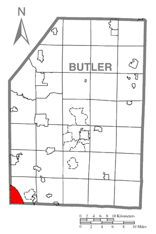
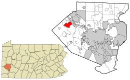
Fernway is a neighborhood in Cranberry Township, Butler County, Pennsylvania, United States. It includes 458 homes on 183 acres and was the first planned housing subdivision in the Township, dating back to the 1950s. Fernway was formerly used as the name of a census-designated place (CDP), but the designation was removed as of TIGER 2013 after Cranberry Township officials pointed out that users of Internet mapping websites frequently misinterpreted the CDP as the name of its parent municipality.

<span class="mw-page-title-main">Fox Run, Pennsylvania</span> Former census-designated place in Pennsylvania, United States

Fox Run is a neighborhood in Cranberry Township, Butler County, Pennsylvania, United States. It is among the Township's earliest housing developments, including 320 homes built on a 131-acre site in the late 1960s. It was formerly a census-designated place (CDP), but that designation was removed as of TIGER 2013 after Cranberry Township officials pointed out that users of Internet mapping websites had misinterpreted the CDP as the name of its parent municipality.

<span class="mw-page-title-main">Geneva, Pennsylvania</span> Census-designated place in Pennsylvania, United States

Geneva is a census-designated place in Crawford County, Pennsylvania, United States. The population was 109 at the 2010 census.

<span class="mw-page-title-main">Lawnton, Pennsylvania</span> Census-designated place in Pennsylvania, United States

Lawnton is an unincorporated area and census-designated place (CDP) in Swatara Township, Dauphin County, Pennsylvania, United States. The population was 3,813 at the 2010 census. It is part of the Harrisburg–Carlisle Metropolitan Statistical Area.

<span class="mw-page-title-main">Oakland, Lawrence County, Pennsylvania</span> Census-designated place in Pennsylvania, United States

Oakland is an unincorporated area and census-designated place (CDP) in Lawrence County, Pennsylvania, United States. The population was 1,569 at the 2010 census.

<span class="mw-page-title-main">Troxelville, Pennsylvania</span> CDP in Pennsylvania, United States

Troxelville is a census-designated place (CDP) in Snyder County, Pennsylvania, United States. The population was 192 at the 2000 census.

<span class="mw-page-title-main">Cecil-Bishop, Pennsylvania</span> CDP in Pennsylvania, United States

Cecil-Bishop is a census-designated place (CDP) in Washington County, Pennsylvania, United States. The population was 2,730 at the 2020 census. The census-designated place encompasses two unincorporated communities: larger Cecil in the west and smaller Bishop in the east.

<span class="mw-page-title-main">Gastonville, Pennsylvania</span> Census-designated place in Pennsylvania, United States

Gastonville is a census-designated place (CDP) in Washington County, Pennsylvania, United States. The population was 2,818 at the 2010 census.

<span class="mw-page-title-main">McGovern, Pennsylvania</span> Census-designated place in Pennsylvania, United States

McGovern is a census-designated place (CDP) in Washington County, Pennsylvania, United States. The population was 2,742 at the 2010 census.

<span class="mw-page-title-main">McMurray, Pennsylvania</span> Census-designated place in Pennsylvania, United States

McMurray is a census-designated place (CDP) in Peters Township, Washington County, Pennsylvania. The population was 4,736 at the 2020 census. It is part of the Pittsburgh metropolitan area. Its zip code is 15317, which it shares with neighboring borough Canonsburg.

<span class="mw-page-title-main">Thompsonville, Pennsylvania</span> Census-designated place in Pennsylvania, United States

Thompsonville is a census-designated place (CDP) in Washington County, Pennsylvania, United States. The population was 3,520 at the 2010 census.

<span class="mw-page-title-main">Wolfdale, Pennsylvania</span> Census-designated place in Pennsylvania, United States

Wolfdale is a census-designated place (CDP) in Washington County, Pennsylvania, United States. The population was 2,888 at the 2010 census.

Lawson Heights is a census-designated place (CDP) in Unity Township, Westmoreland County, Pennsylvania, United States. The population was 2,339 at the 2000 census.

<span class="mw-page-title-main">Hooverson Heights, West Virginia</span> Census-designated place in West Virginia, United States

Hooverson Heights is a census-designated place (CDP) in Brooke County, West Virginia, United States. It is part of the Weirton–Steubenville metropolitan area. The population was 2,590 at the 2010 census.

Cassville is a census-designated place (CDP) in Monongalia County, West Virginia, United States. The population was 1,268 at the 2020 census. It is included in the Morgantown, West Virginia Metropolitan Statistical Area. Cassville was named after Lewis Cass, a prominent American statesman who served as Secretary of War, Secretary of State, and Governor of Michigan.

References

  1. "ArcGIS REST Services Directory". United States Census Bureau. Retrieved October 12, 2022.
  2. 1 2 "Census Population API". United States Census Bureau. Retrieved October 12, 2022.
  3. "Carnot-Moon PA ZIP Code". zipdatamaps.com. 2023. Retrieved January 26, 2023.
  4. "Explore Census Data".
  5. "US Gazetteer files: 2010, 2000, and 1990". United States Census Bureau. February 12, 2011. Retrieved April 23, 2011.
  6. "Census of Population and Housing". Census.gov. Retrieved June 4, 2016.
  7. "U.S. Census website". United States Census Bureau . Retrieved January 31, 2008.