Curtisville, Pennsylvania

Last updated

Curtisville, Pennsylvania
Allegheny County Pennsylvania incorporated and unincorporated areas Curtisville highlighted.svg
Location in Allegheny County and state of Pennsylvania
Coordinates: 40°38′36″N79°50′43″W / 40.64333°N 79.84528°W / 40.64333; -79.84528
Country United States
State Pennsylvania
County Allegheny
Township West Deer
Area
[1]
  Total1.42 sq mi (3.69 km2)
  Land1.42 sq mi (3.69 km2)
  Water0.00 sq mi (0.00 km2)
Population
 (2020) [2]
  Total1,097
  Density770.37/sq mi (297.53/km2)
Time zone UTC-5 (Eastern (EST))
  Summer (DST) UTC-4 (EDT)
ZIP code
15032 [3]
Area code 724
FIPS code 42-17832

Curtisville is a census-designated place (CDP) in West Deer Township, Pennsylvania, United States. The population was 1,097 at the 2020 census. [4]

Contents

Geography

Curtisville is located at 40°38′36″N79°50′43″W / 40.64333°N 79.84528°W / 40.64333; -79.84528 (40.643248, -79.845371). [5]

According to the United States Census Bureau, the CDP has a total area of 1.4 square miles (3.6 km2), all land. Curtisville is within West Deer Township.

Demographics

Historical population
CensusPop.Note
2020 1,097
U.S. Decennial Census [6] [2]

At the 2000 census, there were 1,173 people, 498 households, and 330 families living in the CDP. The population density was 822.5 inhabitants per square mile (317.6/km2). There were 528 housing units at an average density of 370.2 per square mile (142.9/km2). The racial makeup of the CDP was 98.81% White, 0.09% African American, 0.09% Asian, 0.26% from other races, and 0.77% from two or more races. Hispanic or Latino of any race were 1.11%. [7]

There were 498 households, 29.1% had children under the age of 18 living with them, 48.6% were married couples living together, 11.8% had a female householder with no husband present, and 33.7% were non-families. 29.7% of households were made up of individuals, and 13.9% were one person aged 65 or older. The average household size was 2.36 and the average family size was 2.89.

The age distribution was 23.0% under the age of 18, 6.6% from 18 to 24, 32.7% from 25 to 44, 22.1% from 45 to 64, and 15.6% 65 or older. The median age was 39 years. For every 100 females, there were 93.2 males. For every 100 females age 18 and over, there were 88.5 males.

The median household income was $31,304 and the median family income was $36,900. Males had a median income of $38,125 versus $23,710 for females. The per capita income for the CDP was $14,143. About 15.4% of families and 18.7% of the population were below the poverty line, including 24.3% of those under age 18 and 5.6% of those age 65 or over.

History

Curtisville was really three towns: Curtisville #1, Curtisville #2, and Curtisville #3 (now Bairdford), named after the mines that were in each area. For more information on Curtisville go to http://freepages.history.rootsweb.ancestry.com/~westdeertownship/West_Deer_1836-1986-final8.htm#_Toc82621316.

Related Research Articles

<span class="mw-page-title-main">Taft Mosswood, California</span> Census-designated place in California, United States

Taft Mosswood is a census-designated place (CDP) in San Joaquin County, California, United States. The population was 1,530 at the 2010 census, up from 1,388 at the 2000 census. It comprises an unincorporated "island" within the City of Stockton.

<span class="mw-page-title-main">Long Hill, Groton, Connecticut</span> Census-designated place in Connecticut, United States

Long Hill is a census-designated place (CDP) in the town of Groton in New London County, Connecticut, United States. The population was 4,205 at the 2010 census.

<span class="mw-page-title-main">Inwood, Florida</span> Census-designated place in Florida, United States

Inwood is a census-designated place (CDP) in Polk County, Florida, United States. The population was 6,925 at the time of the 2000 United States Census. It is part of the Lakeland–Winter Haven Metropolitan Statistical Area.

<span class="mw-page-title-main">Volcano, Hawaii</span> Census-designated place in Hawaii, U.S.

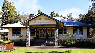
Volcano is a census-designated place (CDP) in Hawaii County, Hawaii, United States located in the District of Puna with a small portion of the CDP in the District of Kaʻū. The population was 2,575 at the 2010 census, up from 2,231 at the 2000 census.

<span class="mw-page-title-main">Chamisal, New Mexico</span> Census-designated place in Taos County, New Mexico, United States

Chamisal is a census-designated place (CDP) in Taos County, New Mexico. It is located along the scenic High Road to Taos. The population was 301 at the time of the 2000 census.

<span class="mw-page-title-main">Walker Valley, New York</span> CDP in New York, United States

Walker Valley is a hamlet located in the western part of the Town of Shawangunk in Ulster County, New York, United States, generally thought of as coterminous with the 12588 ZIP code. The population was 1,269 at the 2020 census.

<span class="mw-page-title-main">Russellton, Pennsylvania</span> Census-designated place in Pennsylvania, United States

Russellton is a census-designated place (CDP) in Allegheny County, Pennsylvania, United States. The population was 1,330 at the 2020 census.

<span class="mw-page-title-main">Lenape Heights, Pennsylvania</span> Census-designated place in Pennsylvania, United States

Lenape Heights is a census-designated place (CDP) in Armstrong County, Pennsylvania, United States. The population was 1,144 at the 2020 census.

<span class="mw-page-title-main">Nixon, Pennsylvania</span> Census-designated place in Pennsylvania, United States

Nixon is a census-designated place (CDP) in Penn Township, Butler County, Pennsylvania, United States. The population was 1,373 at the 2010 census.

<span class="mw-page-title-main">Elim, Pennsylvania</span> Census-designated place in Pennsylvania, United States

Elim is an unincorporated community and census-designated place (CDP) in Upper Yoder Township, Cambria County, Pennsylvania, United States. The population was 3,727 at the 2010 census, down from 4,175 at the 2000 census.

<span class="mw-page-title-main">St. Michael-Sidman, Pennsylvania</span> Former CDP in Pennsylvania, United States

St. Michael-Sidman was a census-designated place (CDP) in Cambria County, Pennsylvania, United States. The population was 973 at the 2000 census. For the 2010 census, the area was split into two CDPs, St. Michael and Sidman.

Black Lick is a census-designated place (CDP) in Burrell Township, Indiana County, Pennsylvania, United States. The population was 1,462 at the 2010 census.

<span class="mw-page-title-main">Fairview-Ferndale, Pennsylvania</span> CDP in Pennsylvania, United States

Fairview-Ferndale is a census-designated place (CDP), located in Coal Township, in Northumberland County, Pennsylvania, United States. The population was 2,411 at the 2000 census.

<span class="mw-page-title-main">Marshallton, Pennsylvania</span> CDP in Pennsylvania, United States

Marshallton is a census-designated place (CDP), located in Coal Township, in Northumberland County, Pennsylvania, United States. The population was 1,441 at the 2010 census.

<span class="mw-page-title-main">Lake Wynonah, Pennsylvania</span> CDP in Pennsylvania, United States

Lake Wynonah is a census-designated place (CDP) in Schuylkill County, Pennsylvania, United States. The population was 1,961 at the 2000 census, and 2,640 at the 2010 census. Lake Wynonah is a gated community with two lakes, Fawn Lake and Lake Wynonah, and as of July 2008, there are over 1200 homes and 1500 members. It is in South Manheim and Wayne Townships.

McKeansburg is a census-designated place (CDP) in Schuylkill County, Pennsylvania. The population was 169 at the 2020 census.

<span class="mw-page-title-main">Wickerham Manor-Fisher, Pennsylvania</span> Census-designated place in Pennsylvania, United States

Wickerham Manor-Fisher is a census-designated place (CDP) in Washington County, Pennsylvania, United States. The population was 1,728 at the 2010 census.

Loyalhanna is a census-designated place (CDP) in Westmoreland County, Pennsylvania, United States. The population was 3,415 at the 2000 census, at which time it was listed as McChesneytown-Loyalhanna, before just becoming the CDP of Loyalhanna for the 2010 census. As of the 2010 census the population was 3,428 residents.

<span class="mw-page-title-main">Rancho Alegre, Texas</span> Census-designated place in Texas, United States

Rancho Alegre is an unincorporated area and census-designated place (CDP) in Jim Wells County, Texas, United States. The population was 1,704 at the 2010 census.

<span class="mw-page-title-main">Piney View, West Virginia</span> Census-designated place in West Virginia, United States

Piney View is a census-designated place (CDP) in Raleigh County, West Virginia, United States. The population was 989 at the 2010 census.

References

  1. "ArcGIS REST Services Directory". United States Census Bureau. Retrieved October 12, 2022.
  2. 1 2 "Census Population API". United States Census Bureau. Retrieved October 12, 2022.
  3. "Curtisville PA ZIP Code". zipdatamaps.com. 2023. Retrieved June 27, 2023.
  4. "Explore Census Data".
  5. "US Gazetteer files: 2010, 2000, and 1990". United States Census Bureau. February 12, 2011. Retrieved April 23, 2011.
  6. "Census of Population and Housing". Census.gov. Retrieved June 4, 2016.
  7. "U.S. Census website". United States Census Bureau . Retrieved January 31, 2008.