Castle Shannon, Pennsylvania

Last updated
Castle Shannon, Pennsylvania
Willow Avenue at Castle Shannon Boulevard, Castle Shannon, 2022-02-08, 01.jpg
Willow Avenue at Castle Shannon Boulevard
Etymology: Local farm named "Castle Shanahan"
Nickname: 
"Shannon"
Allegheny County Pennsylvania incorporated and unincorporated areas Castle Shannon highlighted.svg
Location in Allegheny County and the U.S. state of Pennsylvania.
Coordinates: 40°21′57″N80°1′11″W / 40.36583°N 80.01972°W / 40.36583; -80.01972
Country United States
State Pennsylvania
County Allegheny
IncorporatedDecember 20, 1919
Government
  MayorDonald J. Baumgarten (D) [1]
Area
[2]
  Total1.60 sq mi (4.14 km2)
  Land1.60 sq mi (4.14 km2)
  Water0.00 sq mi (0.00 km2)
Elevation
1,040 ft (320 m)
Population
 (2020) [3]
  Total8,249
  Density5,162.08/sq mi (1,993.39/km2)
Time zone UTC-5 (EST)
  Summer (DST) UTC-4 (EDT)
ZIP Code
15234
Area code 412
FIPS code 42-11680
School District Keystone Oaks
Website borough.castle-shannon.pa.us

Castle Shannon is a borough in Allegheny County, Pennsylvania, United States. The population was 8,249 at the 2020 census. [4] It is part of the Pittsburgh metropolitan area.

Contents

History

The first families settled Castle Shannon in 1786 in pursuit of farmland and timber and is widely assumed to be the Haas family. The most prominent farm was owned by David Strawbridge. Following common practices of Irish settlers—primarily from Ulster—in the region to name places and farms after former or ancestral homes in Ireland, he named it Castle Shanahan. [5] [6] Castleshanaghan is a townland in County Donegal, Ireland. [7] [8] Over time, the farm would lend its name to the area, as "Shanahan" would evolve into "Shannon". In 1872, the Pittsburgh and Castle Shannon Railroad line was completed, providing a direct link from Pittsburgh to the then-village of Castle Shannon. Development was stimulated by two years of free transportation and lumber transport given to anybody building a home. [9]

In 1877, a second railroad was built from Finleyville through Castle Shannon to the West End neighborhood of Pittsburgh. In 1909, the right of way through the valley containing Castle Shannon was purchased by the Pittsburgh Railroad. This helped lead to Castle Shannon becoming a center for coal mining, with eight mines in operation in 1904. The Pittsburgh and West Virginia Railroad, still active today, came shortly afterward.

The First National Bank in Castle Shannon was the site of a much publicized bank robbery in 1917. $18,500 was taken in the robbery, of which $10,500 was immediately recovered from one man shot during the escape. The full sum was never recovered. A group of men gathered to chase down the robber to no avail. From that group, Elmer J Zeiler, a WWI Medal of Valor winner from the US and France, and a double Purple Heart recipient, was named the first Chief of Police in Castle Shannon when the police department was formed.

Castle Shannon was incorporated as a borough in 1919, formed from parts of Baldwin Township, Mt. Lebanon, and Bethel Township.

Geography

According to the United States Census Bureau, the borough has a total area of 1.6 square miles (4.1 km2), all land. Its average elevation is 1,040 feet (320 m) above sea level. [10]

Surrounding communities

Castle Shannon has five borders, including Baldwin Township to the north, the Pittsburgh neighborhood of Overbrook to the northeast, Whitehall to the east and southeast, Bethel Park to the south and southwest, and Mt. Lebanon to the west and northwest.

Demographics

Historical population
CensusPop.Note
1880 306
1920 2,353
1930 3,81061.9%
1940 3,9704.2%
1950 5,45937.5%
1960 11,836116.8%
1970 12,0361.7%
1980 10,164−15.6%
1990 9,135−10.1%
2000 8,556−6.3%
2010 8,316−2.8%
2020 8,249−0.8%
Sources: [11] [12] [13] [14] [15] [16] [17] [3]

As of the census [16] of 2000, there were 8,556 people, 3,859 households, and 2,288 families residing in the borough. The population density was 5,259.8 inhabitants per square mile (2,030.8/km2). There were 4,037 housing units at an average density of 2,481.8 per square mile (958.2/km2). The racial makeup of the borough was 96.91% White, 1.34% African American, 0.06% Native American, 0.78% Asian, 0.01% Pacific Islander, 0.39% from other races, and 0.50% from two or more races. Hispanic or Latino of any race were 0.98% of the population.

There were 3,859 households, out of which 23.2% had children under age 18 living with them, 45.3% were married couples living together, 10.7% had a female householder with no husband present, and 40.7% were non-families. 35.1% of all households were made up of individuals, and 12.5% had someone living alone who was 65 years old or older. The average household size was 2.20 persons, and the average family size was 2.88 persons. In the borough the population was spread out, with 19.7% under age 18, 7.3% from 18 to 24 years old, 32.9% from 25 to 44 years old, 21.4% from 45 to 64 years old, and 18.7% who were 65 years old or older. The median age was 39. For every 100 females, there were 90.0 males. For every 100 females age 18 and over, there were 85.5 males. The median income for a household in the borough was $38,040; and, the median income for a family was $48,586. Males had a median income of $33,013, versus $27,907 for females. The per capita income for the borough was $20,518. About 5.0% of families and 7.7% of the population were below the poverty line, including 9.4% of those under age 18 and 7.8% of those age 65 or over.

Government and politics

Presidential Elections Results [18] [19]
Year Republican Democratic Third Parties
2020 41%2,01458%2,8441%56
2016 42%1,82353%2,2924%188
2012 44%1,73855%2,1801%37

Schools

Castle Shannon's school system, Keystone Oaks School District, is a "jointure" [ clarification needed ] with the boroughs of Dormont and Green Tree, comprising Keystone Oaks Middle and High Schools, Myrtle Elementary School (Castle Shannon), Dormont Elementary School (Dormont), and Aiken Elementary School (Greentree). Located within Castle Shannon is Saint Anne School, a Catholic private elementary school.

Notable people

Related Research Articles

<span class="mw-page-title-main">Baldwin Township, Allegheny County, Pennsylvania</span> Township in Pennsylvania, United States

Baldwin Township is a township in Allegheny County, Pennsylvania, United States. The population was 1,984 at the 2020 census, a decrease from the figure of 1,992 tabulated in 2010.

<span class="mw-page-title-main">Ben Avon, Pennsylvania</span> Borough in Pennsylvania, United States

Ben Avon is a borough in Allegheny County, Pennsylvania, United States, along the Ohio River. The population was 1,918 at the 2020 census. It is part of the Pittsburgh metropolitan area.

<span class="mw-page-title-main">Brackenridge, Pennsylvania</span> Borough in Pennsylvania, United States

Brackenridge is a borough in Allegheny County, Pennsylvania, United States, located along the Allegheny River. It is part of the Greater Pittsburgh metropolitan area.

<span class="mw-page-title-main">Bradford Woods, Pennsylvania</span> Borough in Pennsylvania, United States

Bradford Woods is a borough in Allegheny County, Pennsylvania, United States. The population was 1,183 at the 2020 census. A suburb of the Pittsburgh metropolitan area, it is part of the North Allegheny School District and participates in the multi-municipality Northland Public Library. It is home to Bradford Woods Elementary School.

<span class="mw-page-title-main">Cheswick, Pennsylvania</span> Borough in Pennsylvania, United States

Cheswick is a borough in Allegheny County, Pennsylvania, United States, along the Allegheny River. The population was 1,672 as of the 2020 census. Cheswick Borough was incorporated in 1902. It is a residential suburb of the Pittsburgh metropolitan area.

<span class="mw-page-title-main">Crafton, Pennsylvania</span> Borough in Pennsylvania, United States

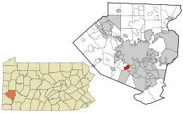
Crafton is a borough in Allegheny County, Pennsylvania, United States, west of downtown Pittsburgh. The population was 6,099 at the 2020 census. It is a residential suburb of the Pittsburgh metropolitan area.

<span class="mw-page-title-main">Dormont, Pennsylvania</span> Borough in Pennsylvania, United States

Dormont is a borough in Allegheny County, Pennsylvania, United States. The population was 8,244 at the 2020 census. It is a residential suburb of the Pittsburgh metropolitan area. Loosely translated, Dormont means "Mountain of Gold" in French.

<span class="mw-page-title-main">East Pittsburgh, Pennsylvania</span> Borough in Pennsylvania, United States

East Pittsburgh is a borough in Allegheny County, Pennsylvania, United States, approximately 11 miles (18 km) southeast of the confluence of the Monongahela and the Allegheny rivers at Pittsburgh. The population in 1900 stood at 2,883, and in 1910, at 5,615. As of the 2020 census, the borough population was 1,927, having fallen from 6,079 in 1940. George Westinghouse erected large works there which supplied equipment to the great power plants at Niagara Falls and for the elevated and rapid-transit systems of New York. Nearby, the George Westinghouse Bridge over Turtle Creek is a prominent fixture in the area, which is very near the borough of Braddock.

<span class="mw-page-title-main">Mt. Lebanon, Pennsylvania</span> Home rule municipality in Pennsylvania, United States

Mt. Lebanon is a township with home rule status in Allegheny County, Pennsylvania, United States. The population was 34,075 at the 2020 census. It is a suburb of Pittsburgh. Established in 1912 as Mount Lebanon, the township was a farming community. With the arrival of the first streetcar lines and the development of the first real estate subdivision, both in 1901, it became a streetcar suburb, offering residents the ability to commute to Downtown Pittsburgh. Further, the opening of the Liberty Tunnel in 1924 allowed easy automobile access to Pittsburgh. In 1975, the renamed Mt. Lebanon adopted one of the first home rule charters in Pennsylvania.

<span class="mw-page-title-main">Ohio Township, Allegheny County, Pennsylvania</span> Township in Pennsylvania, United States

Ohio Township is a township of the Second Class in Allegheny County, Pennsylvania, United States. Ohio Township elects a board of three Supervisors, a property tax collector, and a constable. The day-to-day business of the township is managed by a Township Manager serving at will. In addition to the Administration Office, the Police Department, Road Department, and Recreation Department are also under the direct administration of the Board of Supervisors. The Ohio Township Police Department provides full-time service, not only for Ohio Township, but through contractual agreements also for the Townships of Aleppo, Kilbuck, and Neville and the Boroughs of Ben Avon, Ben Avon Heights, Emsworth and Sewickley Hills.

<span class="mw-page-title-main">Pitcairn, Pennsylvania</span> Borough in Pennsylvania, United States

Pitcairn is a borough in Allegheny County, Pennsylvania, United States, located 12 miles (19 km) east of Pittsburgh's central business district, named for Robert Pitcairn, an official of the Pennsylvania Railroad.

<span class="mw-page-title-main">Plum, Pennsylvania</span> Borough in Pennsylvania, United States

Plum is a borough in Allegheny County, Pennsylvania, United States. The population was 27,144 at the 2020 census. A suburb of the Pittsburgh metropolitan area, it is located northeast of the city in what is commonly referred to as the East Hills suburbs.

<span class="mw-page-title-main">Springdale, Pennsylvania</span> Borough in Pennsylvania, United States

Springdale is a borough in northeastern Allegheny County, Pennsylvania, United States, 18 miles (29 km) northeast of Pittsburgh along the Allegheny River. The population was 3,400 at the 2020 census. The borough became official in 1906, after breaking away from the township.

<span class="mw-page-title-main">Tarentum, Pennsylvania</span> Borough in Pennsylvania, United States

Tarentum is a borough in Allegheny County in the U.S. state of Pennsylvania. It is 22 miles (35 km) northeast of Downtown Pittsburgh, along the Allegheny River. Tarentum was an industrial center where plate glass and bottles were manufactured; bricks, lumber, steel and iron novelties, steel billets and sheets, sack and wrapping paper were also produced.

<span class="mw-page-title-main">Verona, Pennsylvania</span> Borough in Pennsylvania, United States

Verona is a borough in Allegheny County, Pennsylvania, United States. It is 13 miles (21 km) northeast of downtown Pittsburgh, along the left bank of the Allegheny River. As of the 2020 census, the borough had a population of 2,492.

<span class="mw-page-title-main">Wall, Pennsylvania</span> Borough in Pennsylvania, United States

Wall is a borough in Allegheny County, Pennsylvania, United States. The population was 519 at the 2020 census.

<span class="mw-page-title-main">Whitehall, Allegheny County, Pennsylvania</span> Borough in Pennsylvania, United States

Whitehall is a borough in Allegheny County, Pennsylvania, United States. It is part of the Pittsburgh metropolitan area. The population was 15,064 at the 2020 census, an increase of 1,120 since the 2010 census.

<span class="mw-page-title-main">Mars, Pennsylvania</span> Borough in Pennsylvania, United States

Mars is a borough in southern Butler County, Pennsylvania, United States. The population was 1,458 at the 2020 census. It is part of the Pittsburgh metropolitan area.

<span class="mw-page-title-main">Cresson, Pennsylvania</span> Borough in Pennsylvania, United States

Cresson is a borough in Cambria County, Pennsylvania, United States. Cresson is 80 miles (130 km) east of Pittsburgh. It is above 2,000 feet (600 m) in elevation. Lumber, coal, and coke yards were industries that had supported the population, which numbered 1,470 in 1910. The borough is part of the Johnstown Metropolitan Statistical Area, although state and local sources list it as part of the Altoona area due to being much closer to that city. The population of Cresson at the 2010 census was 1,711.

<span class="mw-page-title-main">Smithton, Pennsylvania</span> Borough in Pennsylvania, United States

Smithton is a borough in Westmoreland County, Pennsylvania, United States. The population was 399 at the 2010 census. As of 2018, the population was listed at 378. Smithton has its own post office, with zip code 15479, and is serviced by Yough School District.

References

  1. Donald J. Baumgarten profile Archived 2011-07-19 at the Wayback Machine , borough.castle-shannon.pa.us; accessed May 15, 2016.
  2. "ArcGIS REST Services Directory". United States Census Bureau. Retrieved October 12, 2022.
  3. 1 2 "Census Population API". United States Census Bureau. Retrieved Oct 12, 2022.
  4. "Explore Census Data".
  5. Gilmore, Peter. "From Rostrevor to Raphoe: An Overview of Ulster Place-Names in Pennsylvania, 1700-1820".
  6. "The History of Castle Shannon – Castle Shannon".
  7. "Castle Shanaghan".
  8. "Cashelshanaghan Townland, Co. Donegal".
  9. Allegheny County Municipalities, Pittsburgh Post-Gazette ; retrieved May 15, 2016.
  10. "US Board on Geographic Names". United States Geological Survey. October 25, 2007. Retrieved May 15, 2016.
  11. "Population of Civil Divisions Less than Counties" (PDF). 1880 United States Census. U.S. Census Bureau. Retrieved 24 November 2013.
  12. "Population-Pennsylvania" (PDF). U.S. Census 1910. U.S. Census Bureau. Retrieved 22 November 2013.
  13. "Number and Distribution of Inhabitants:Pennsylvania-Tennessee" (PDF). Fifteenth Census. U.S. Census Bureau.
  14. "Number of Inhabitants: Pennsylvania" (PDF). 18th Census of the United States. U.S. Census Bureau. Retrieved November 22, 2013.
  15. "Pennsylvania: Population and Housing Unit Counts" (PDF). U.S. Census Bureau. Retrieved November 22, 2013.
  16. 1 2 "U.S. Census website". United States Census Bureau . Retrieved May 15, 2016.
  17. "Annual Estimates of the Resident Population". U.S. Census Bureau. Archived from the original on 2013-10-19. Retrieved 22 November 2013.
  18. EL. "2012 Allegheny County election". Pittsburgh Tribune-Review. Retrieved 15 October 2017.
  19. EL. "2016 Pennsylvania general election..." Pittsburgh Post-Gazette. Retrieved 15 October 2017.
  20. Wolfe, Jennifer (December 30, 2012). "Obituary: Leland 'Lee' Hartman: Pittsburgh animator who once worked at Disney Feb. 27 1930 - Dec. 24, 2012". Pittsburgh Post-Gazette . Retrieved May 15, 2016.
Preceded by Bordering communities
of Pittsburgh
Succeeded by