
McDowell County is a county located in the U.S. state of North Carolina. As of the 2020 census, the population was 44,578. Its county seat is Marion.

Gaston County is a county in the U.S. state of North Carolina. As of the 2020 census, the population was 227,943. The county seat is Gastonia. Dallas served as the original county seat from 1846 until 1911.

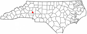
Catawba County is a county in the U.S. state of North Carolina. As of the 2020 census, the population was 160,610. Its county seat is Newton, and its largest community is Hickory.
Sherrills Ford is an unincorporated community and former census-designated place (CDP) in Catawba County, North Carolina, United States. The population was 941 at the 2000 census. For the 2010 census it was included within the Lake Norman of Catawba CDP. It is part of the Hickory-Lenoir-Morganton Metropolitan Statistical Area.

Beckley is a city in and the county seat of Raleigh County, West Virginia, United States. The population was 17,286 at the 2020 census, making it the ninth-largest city in the state. It is the principal city of the Beckley metropolitan area of Southern West Virginia, home to 115,079 residents in 2020. Beckley was founded on April 4, 1838, and was long known for its ties to the coal mining industry. It is the home of the West Virginia University Institute of Technology, as well as campuses of Concord University and the University of Charleston.
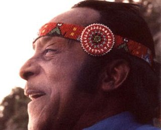
Red Thunder Cloud, born Cromwell Ashbie Hawkins West, also known as Carlos Westez, was a singer, dancer, storyteller, and field researcher. For a time he was promoted by anthropologists as "the last fluent speaker of the Catawba language" but he was later revealed to have learned what little he knew of the language from books. The grandson of a prominent African-American attorney and community leader, Red Thunder Cloud was an African American who reinvented himself as a Native American.

The Catawba, also known as Issa, Essa or Iswä but most commonly Iswa, are a federally recognized tribe of Native Americans, known as the Catawba Indian Nation. Their current lands are in South Carolina, on the Catawba River, near the city of Rock Hill. Their territory once extended into North Carolina, as well, and they still have legal claim to some parcels of land in that state. They were once considered one of the most powerful Southeastern tribes in the Carolina Piedmont, as well as one of the most powerful tribes in the South as a whole, with other, smaller tribes merging into the Catawba as their post-contact numbers dwindled due to the effects of colonization on the region.
Denver, formerly known as Dry Pond, is a census-designated place and unincorporated community in Lincoln County, North Carolina, United States. As of the 2010 census it had a population of 2,309.
Catawba College is a private college in Salisbury, North Carolina. Founded in 1851 by the North Carolina Classis of the Reformed Church in Newton, the college adopted its name from its county of origin, Catawba County, before moving to its current home of Salisbury in 1925. Catawba College still holds loose ties with the successor to the Reformed Church, the United Church of Christ. It offers over 70 undergraduate degrees.

Virginia State Route 311 and West Virginia Route 311 are adjoining state highways in the U.S. states of Virginia and West Virginia. The two state highways together run 58.7 miles (94.5 km) from U.S. Route 11 in Salem, Virginia north to Interstate 64 and U.S. Route 60 near White Sulphur Springs, West Virginia. The two Virginia portions of Route 311 are maintained by the Virginia Department of Transportation, with the exception of the city-maintained portion within Salem. The West Virginia segments are maintained by the West Virginia Division of Highways.

The Great Indian Warpath (GIW)—also known as the Great Indian War and Trading Path, or the Seneca Trail—was that part of the network of trails in eastern North America developed and used by Native Americans which ran through the Great Appalachian Valley. The system of footpaths extended from what is now upper New York to deep within Alabama. Various Native peoples traded and made war along the trails, including the Catawba, numerous Algonquian tribes, the Cherokee, and the Iroquois Confederacy. The British traders' name for the route was derived from combining its name among the northeastern Algonquian tribes, Mishimayagat or "Great Trail", with that of the Shawnee and Delaware, Athawominee or "Path where they go armed".
Catawba is an unincorporated community in the northern section of Roanoke County, Virginia, United States. Catawba occupies the Catawba Valley bound on the south by the north slope of Catawba Mountain and on the north by several mountains which form the border between Roanoke County and Craig County. The primary road through Catawba is State Route 311. Catawba has a post office with the zip code of 24070.

The Hickory-Lenoir-Morganton, NC Metropolitan Statistical Area, as defined by the United States Census Bureau, is an area consisting of four counties, Catawba, Burke, Caldwell, Alexander. It is located in the Catawba Valley region of western North Carolina. Local residents often refer to the area as The Unifour, although this name is largely unknown outside of the region.
Nathalie is an unincorporated community and census-designated place (CDP) in Halifax County, Virginia, United States, in the south-central region of the state. The population as of the 2010 census was 183.

The Devonian Foreknobs Formation is a mapped bedrock unit in Pennsylvania, Maryland, Virginia, and West Virginia.

McDonalds Mill is an unincorporated community in the northeastern section of Montgomery County, Virginia. Located approximately 10 miles east of Blacksburg, Virginia along State Route 785, McDonalds Mill lies at the floor of the Catawba Valley and is bound on the south by Paris Mountain and to the north by Gallion Ridge.

The Charlotte metropolitan area, sometimes referred to as Metrolina, is a metropolitan area of the U.S. states of North and South Carolina, containing the city of Charlotte. The metropolitan area also includes the cities of Gastonia, Concord, Huntersville, and Rock Hill as well as the large suburban area in the counties surrounding Mecklenburg County, which is at the center of the metro area. Located in the Piedmont, it is the largest metropolitan area in the Carolinas, and the fourth largest in the Southeastern United States. The Charlotte metropolitan area is one of the fastest growing metropolitan areas in the United States.
Catawba is one of two Eastern Siouan languages of the eastern US, which together with the Western Siouan languages formed the Siouan language family.
The Catawba in the American Civil War participated in the Eastern Theater. From the very beginning, the Catawba allied themselves with the Confederacy, remaining loyal until the end of the War. They enrolled with the 5th, 12th, and 17th South Carolina Infantry Regiments.


