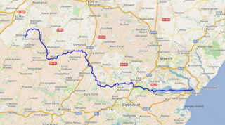
The River Stour is a major river in East Anglia, England. It is 47 miles (76 km) long and forms most of the county boundary between Suffolk to the north, and Essex to the south. It rises in eastern Cambridgeshire, passes to the east of Haverhill, through Cavendish, Sudbury, Bures, Nayland, Stratford St Mary and Dedham. It becomes tidal just before Manningtree in Essex and joins the North Sea at Harwich.

Suffolk Wildlife Trust (SWT) describes itself as the county's "nature charity – the only organisation dedicated wholly to safeguarding Suffolk's wildlife and countryside." It is a registered charity, and its headquarters is at Brooke House in Ashbocking, near Ipswich. It was founded in 1961, and is one of 46 wildlife trusts covering the Great Britain and Northern Ireland. As of March 2017, it has 13,200 members, and it manages 3,120 hectares of land in 60 nature reserves, most of which are open to the public. It had an income of £3.9 million in the year to 31 March 2017.

Dedham Vale National Landscape is a designated Area of Outstanding Natural Beauty on the Essex-Suffolk border in east England. It comprises the area around the River Stour between Manningtree and Smallbridge Farm, 1 mile (1.6 km) east of Bures, including the village of Dedham in Essex.

Colne Estuary is a 2915 hectare biological and geological Site of Special Scientific Interest near Brightlingsea in Essex. It is also a Nature Conservation Review site, a National Nature Reserve, a Ramsar wetland site of international importance, a Special Protection Area, a Special Area of Conservation, and a Geological Conservation Review site. Three areas in the site are managed by the Essex Wildlife Trust, Colne Point, Fingringhoe Wick and Howlands Marsh.
Dungeness, Romney Marsh and Rye Bay is a 10,172.9-hectare (25,138-acre) biological and geological Site of Special Scientific Interest which stretches from New Romney in Kent to Winchelsea in East Sussex. An area of 5,129.5 hectares is a Special Protection Area, an area of 3,141.1 hectares is a Special Area of Conservation, and an area of 6,377.6 hectares is a Ramsar Site, a wetland site designated of international importance under the Ramsar Convention. Part of the site is in the High Weald Area of Outstanding Natural Beauty, parts are Geological Conservation Review sites, part is a Local Nature Reserve, and part is a Royal Society for the Protection of Birds nature reserve, and part is a National Nature Reserve.

Trimley Marshes is a 77 hectare nature reserve west of Trimley St Mary, on the outskirts of Felixstowe in Suffolk. It is managed by the Suffolk Wildlife Trust. It is in the Suffolk Coast and Heaths Area of Outstanding Natural Beauty, the Orwell Estuary Site of Special Scientific Interest, the Stour and Orwell Estuaries Ramsar site internationally important wetland site and Special Protection Area under the European Union Directive on the Conservation of Wild Birds.
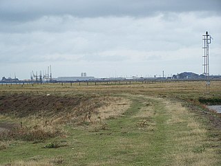
Stour Wood is a woodland in Essex, England, near the village of Wrabness. It covers a total area of 54.07 hectares. It is owned by the Woodland Trust, and managed by the Royal Society for the Protection of Birds. It is part of the Stour and Copperas Woods, Ramsey Site of Special Scientific Importance.

The Crouch and Roach Estuaries are a 1729 hectare biological Site of Special Scientific Interest (SSSI) at the mouth of the Crouch and Roach rivers in Essex. The Crouch part of the SSSI stretches from near Battlesbridge to Foulness Island, and the Roach from Rochford to the junction with the Crouch. Part of the site is in the Mid-Essex Coast Special Protection Area under the EC Directive on the Conservation of Wild Birds, and a Ramsar wetland site of international importance. It is also part of the Essex Estuaries Special Area of Conservation. An area of 65 hectares is managed by the Essex Wildlife Trust as the Lion Creek and Lower Raypits nature reserve and 8 hectares at Woodham Fen, both of which are managed by the Essex Wildlife Trust. A small area is also a geological SSSI, The Cliff, Burnham-on-Crouch.

Stour and Copperas Woods, Ramsey is a 77.1-hectare (191-acre) biological Site of Special Scientific Interest between Wrabness and Ramsey in Essex. It is two separate areas, Stour Wood, which is owned by the Woodland Trust and managed by the Royal Society for the Protection of Birds, and Copperas Wood, which is owned and managed by the Essex Wildlife Trust. It is in the Suffolk Coast and Heaths Area of Outstanding Natural Beauty.
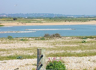
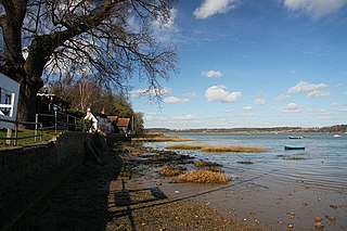
Stour Estuary is a 2,523 hectare biological and geological Site of Special Scientific Interest which stretches from Manningtree to Harwich in Essex and Suffolk. It is also an internationally important wetland Ramsar site, a Special Protection Area and a Nature Conservation Review site. It is part of the Suffolk Coast and Heaths Area of Outstanding Natural Beauty, and there are Geological Conservation Review sites in Wrabness, Stutton, and Harwich Part of the site is managed by the Royal Society for the Protection of Birds, and a small area is Wrabness Nature Reserve, a Local Nature Reserve managed by the Essex Wildlife Trust.

Leiston - Aldeburgh is a 534.8-hectare (1,322-acre) biological Site of Special Scientific Interest which stretches from Aldeburgh to Leiston in Suffolk. Part of it is The Haven, Aldeburgh Local Nature Reserve, and another area is the North Warren RSPB nature reserve. There is also a prehistoric bowl barrow on Aldringham Common, which is a Scheduled Monument. The site is in the Sandlings Special Protection Area under the European Union Directive on the Conservation of Wild Birds, and the Suffolk Coast and Heaths Area of Outstanding Natural Beauty.
Orwell Estuary is a 1,335.7 hectare biological Site of Special Scientific Interest which stretches along the River Orwell and its banks between Felixstowe and Ipswich in Suffolk. It is part of the Stour and Orwell Estuaries Ramsar site internationally important wetland site and Special Protection Area under the European Union Directive on the Conservation of Wild Birds. It is also in the Suffolk Coast and Heaths Area of Outstanding Natural Beauty.
Medway Estuary and Marshes is a 4,748.8-hectare (11,735-acre) biological Site of Special Scientific Interest which stretches along the banks of the River Medway between Gillingham and Sheerness in Kent. It is a Nature Conservation Review site, Grade I, a Ramsar internationally important wetland site, and a Special Protection Area under the European Union Directive on the Conservation of Wild Birds. Part of the land area designated as Medway Estuary and Marshes SSSI is owned by the Church Commissioners.

Preston Marshes is a 43.4-hectare (107-acre) biological Site of Special Scientific Interest east of Canterbury in Kent.

Stodmarsh SSSI is a 623.2-hectare (1,540-acre) biological Site of Special Scientific Interest near Stodmarsh, north-east of Canterbury in Kent. Parts of it are a Nature Conservation Review site, Grade I, a National Nature Reserve, a Ramsar internationally important wetland site, a Special Area of Conservation and a Special Protection Area under the European Union Directive on the Conservation of Wild Birds.
Thursley, Hankley and Frensham Commons is a 1,878.5-hectare (4,642-acre) biological Site of Special Scientific Interest west of Godalming in Surrey. Thursley and Hankley Commons are Nature Conservation Review sites, Grade I. An area of 115.1 hectares is a local nature reserve called The Flashes and an area of 180 hectares is the Elstead Group of Commons, a nature reserve managed by the Surrey Wildlife Trust. Thursley Common is a national nature reserve. An area of 265.7 hectares is the Thursley & Ockley Bogs Ramsar site. The site is a Special Protection Area and part of the Thursley, Ash, Pirbright & Chobham Special Area of Conservation. Part of the land area designated as Thursley, Hankley and Frensham Commons SSSI is owned by the Ministry of Defence.
