
The City of Chelmsford is a local government district in Essex, England. It is named after its main settlement, Chelmsford, which is also the county town of Essex. On 1 June 2012 Chelmsford was granted city status to mark the Diamond Jubilee of Elizabeth II.
The Borough of Brentwood is a local government district and borough in Essex in the East of England.

The Essex Wildlife Trust (EWT) is one of 46 wildlife trusts which cover the United Kingdom. The EWT was founded in 1959, and it describes itself as Essex's leading conservation charity, which aims to protect wildlife for the future and the people of the county. As of January 2017, it has over 34,000 members and runs 87 nature reserves, 2 nature parks and 11 visitor centres.

Brentwood and Ongar is a constituency in Essex represented in the House of Commons of the UK Parliament since 2017 by Alex Burghart, a Conservative, serving since September 2021 as Parliamentary Under-Secretary of State for Apprenticeships and Skills.

Hainault Forest Country Park is a Country Park located in Greater London, with portions in: Hainault in the London Borough of Redbridge; the London Borough of Havering; and in the Lambourne parish of the Epping Forest District in Essex.

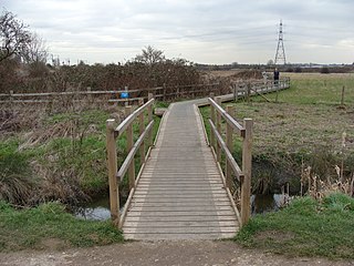
Ingrebourne Valley is a local nature reserve (LNR) in Hornchurch in the London Borough of Havering. It is owned and managed by Havering Council, and has a visitor centre managed by the Essex Wildlife Trust. Most of it is in Hornchurch Country Park west of the River Ingrebourne, but there are also areas north and south of the park which are part of the LNR. It has a wide range of habitats, including woodland, grassland, the river and marshes. It is an important site for a range of species of plants, animals and birds, including great crested newts, slow worms, the harvest mouse and the water vole.
Walthamstow Marshes, is a 36.7-hectare (91-acre) biological Site of Special Scientific Interest in Walthamstow in the London Borough of Waltham Forest. It was once an area of lammas land – common land used for growing crops and grazing cattle.

The Chingford Reservoirs are the King George V Reservoir and the William Girling Reservoir, which form part of the Lee Valley Reservoir Chain in the London Boroughs of Enfield and Waltham Forest and Epping Forest in Essex. Construction of the King George V Reservoir was started in 1908 and completed in 1912. Work on the William Girling Reservoir was started in 1938, with John Mowlem & Co being the contractor, but owing to technical problems, and the intervention of World War II, the reservoir was not finished until 1951.
Chipstead Downs is a 157.8-hectare (390-acre) biological Site of Special Scientific Interest south-east of Banstead in Surrey. Part of it is Park Downs, which is managed by the Banstead Commons Conservators.

Ingrebourne Marshes are a 74.8 hectare biological Site of Special Scientific Interest in Hornchurch in the London Borough of Havering. Ingrebourne Valley Local Nature Reserve includes a small part of the SSSI west of the River Ingrebourne. The site is managed by the Essex Wildlife Trust

The Cornmill Stream and Old River Lea is a 24.6-hectare (61-acre) biological Site of Special Scientific Interest in Waltham Abbey, Essex.

Riddlesdown Common or Riddlesdown is a 43 hectare area of green space in Kenley, towards the northern end of the North Downs in the London Borough of Croydon. It is owned and maintained by the City of London Corporation, apart from two small areas, one of which is operated by the London Wildlife Trust and the other by Croydon Council. An area of 32 hectares is a biological Site of Special Scientific Interest. The name Riddlesdown also applies to the local district of residential housing. A trig point at the site indicates that it is 525 ft (160 m) above sea level.

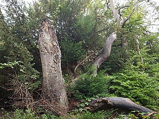
Roding Valley Meadows is an 18.9-hectare (47-acre) biological Site of Special Scientific Interest in Buckhurst Hill in Essex. It is part of a 65.2 hectare Local Nature Reserve with the same name, which is owned by Epping Forest District Council and Grange Farm Trust, and managed by the Essex Wildlife Trust.

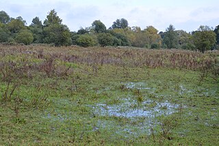
Hunsdon Mead is a 34 hectare biological Site of Special Scientific Interest (SSSI) west of Harlow and east of Roydon in Essex. The site is partly in Essex and partly in Hertfordshire, and it is jointly owned and managed by the Essex Wildlife Trust and the Herts and Middlesex Wildlife Trust. The SSSI also includes part of the neighbouring Roydon Mead. The planning authorities are East Hertfordshire District Council and Epping Forest District Council. Hunsdon Mead is registered common land.
Little Hallingbury Marsh is a 4.5-hectare (11-acre) biological Site of Special Scientific Interest adjacent to the River Stort, west of Little Hallingbury in Essex. It was notified under Section 28 of the Wildlife and Countryside Act 1981, and the local planning authority is Uttlesford District Council.

Grays Thurrock Chalk Pit is a 17.3 hectare Site of Special Scientific Interest in Grays in Essex. It is part of Chafford Gorges Nature Park, which is managed by the Essex Wildlife Trust.

Garrold's Meadow is a 5 hectare biological Site of Special Scientific Interest north of Leigh-on-Sea in Essex. The local planning authority is Castle Point Borough Council.

Thorndon Park is a 141.4-hectare (349-acre) biological Site of Special Scientific Interest in Brentwood in Essex. Part of it is run by Essex County Council as Thorndon Country Park, and the Essex Wildlife Trust manages its visitor centre.
