Centreville, Virginia

Last updated

Centreville
2019-07-22 15 58 26 View east along Interstate 66 and U.S. Route 29 (Lee Highway) from an airplane heading for Washington Dulles International Airport passing over Virginia State Route 28 in Centreville, Fairfax County, Virginia.jpg
An aerial view of SR 28 (bottom), I-66 (left) and US 29 (right) in Centreville in July 2019
Fairfax County Virginia Incorporated and Unincorporated Areas Centreville highlighted.svg
Location of Centreville in Fairfax County, Virginia
USA Virginia Northern location map.svg
Red pog.svg
Centreville
USA Virginia location map.svg
Red pog.svg
Centreville
Usa edcp location map.svg
Red pog.svg
Centreville
Coordinates: 38°50′33″N77°26′33″W / 38.84250°N 77.44250°W / 38.84250; -77.44250
CountryUnited States
State Virginia
County Fairfax
Area
   Census-designated Place (CDP)12.05 sq mi (31.2 km2)
  Land11.94 sq mi (30.9 km2)
  Water.11 sq mi (0.3 km2)
Elevation
384 ft (117 m)
Population
 (2020) [1]
   Census-designated Place (CDP)73,518
  Density6,157/sq mi (2,377/km2)
   Urban
4,586,770
   Metro
6,385,162
Time zone UTC-5 (EST)
  Summer (DST) UTC-4 (EDT)
ZIP Codes
20120-20122
Area code(s) 703, 571
FIPS code 51-14440 [2]
GNIS feature ID1491083 [3]

Centreville is a census-designated place (CDP) in Fairfax County, Virginia, United States. It is a suburb of Washington, D.C., the nation's capital. It had a population of 73,518, making it the most-populous community in Fairfax County as of the 2020 U.S. census [4] [1]

Contents

Centreville is approximately 20 miles (32 km) west of Washington, D.C.

History

Colonial period

Beginning in the 1760s, the area was known as Newgate due to the popularity of the conveniently located Newgate tavern. William Carr Lane operated the tavern and was co-proprietor of a nearby store with James Lane, Jr. [5] The Lanes sold convicted servants, which may explain why the tavern had the same name as a London prison. [6] The small stream that passed near the tavern was named the River Thames, another London association. [7] Another reason for it being named Newgate, was the fact that it was a "new gate" to the western territories.

18th century

The town of Centerville, shortly later spelled Centreville, was established in 1792 on the turnpike road at the village of Newgate by the Virginia General Assembly in response to petitions by local landowners. [8] The petitioners reasoned that a town on the turnpike road leading from the Northwest Territory and centrally located to Alexandria, Colchester, Dumfries, Middleburg, George Town (later Georgetown), Fauquier Court House (later Warrenton), and Leesburg would be convenient. The town acquired its name due to its central location. James Hardage Lane, one of the landowners, conceived the idea of the town as a way to provide financial support to his widow and their children. [9] At the town's inception, it was within the boundary of Loudoun County, Virginia, and became part of Fairfax County, Virginia, in 1798 when the boundary between the two counties shifted. [10]

Town development established a pattern of mixed residential and commercial use. Frame houses, several taverns, stores, blacksmith shops, tan yards, and a school house were constructed on the 1/2-acre town lots.

American Civil War

Main street and church guarded by Union Army in Centreville, in May 1862 at the beginning of the American Civil War Centreville 1862.jpg
Main street and church guarded by Union Army in Centreville, in May 1862 at the beginning of the American Civil War
Departure from the old Homestead, a 1862 photograph depicting pro-Union refugees "Departure from the old Homestead".jpg
Departure from the old Homestead, a 1862 photograph depicting pro-Union refugees

In the American Civil War, several battles were fought nearby including the First Battle of Manassas, the Second Battle of Manassas, and the Battle of Chantilly.

During the winter of 1861 and early 1862 the town was significantly fortified by the Confederacy and served as a supply depot for both sides at various points in the war, and is famous for being the site of the construction of the first railroad ever built exclusively for military use, the Centreville Military Railroad. Centreville was of significant strategic value due to its proximity to several important roads, while its position atop a high ridge provided a commanding view of the surrounding area. The town was frequently associated with Confederate Colonel John S. Mosby, whose partisan rangers used its hillsides and farms as a base of operations, leading to the sobriquet "Mosby's Confederacy".[ citation needed ]

20th and 21st centuries

Like much of Northern Virginia, Centreville experienced sustained population growth in the 1990s and 2000s. In 2021, the town has grown significantly. There are numerous shopping centers built around the town center.

Geography

Location of Centreville, Virginia VAMap-doton-Centreville.PNG
Location of Centreville, Virginia

Centreville is located at 38°50′33″N77°26′33″W / 38.84250°N 77.44250°W / 38.84250; -77.44250 (38.842470, −77.442621). [11]

According to the United States Census Bureau (2010), the CDP has a total area of 12.04 square miles (31.2 km2), 99% of it land.

Climate

Like Washington D.C., Centreville features a mid-latitude, four seasons version of the humid subtropical climate (Köppen: Cfa), typical of the Mid-Atlantic region, including strong hot-summer humid continental climate (Köppen: Dfa) influences under the Köppen system. Winters are chilly and damp, with frost at night and some snow, while summers are hot and wet, with subtropical temperatures although these temperatures are hardly more bearable than in the south.

MonthJanFebMarAprMayJunJulAugSepOctNovDecYear
Record high °F (°C)80
(27)
84
(29)
93
(34)
95
(35)
99
(37)
104
(40)
106
(41)
106
(41)
104
(40)
98
(37)
86
(30)
79
(26)
106
(41)
Mean maximum °F (°C)66.7
(19.3)
68.1
(20.1)
77.3
(25.2)
86.4
(30.2)
91.0
(32.8)
95.7
(35.4)
98.1
(36.7)
96.5
(35.8)
91.9
(33.3)
84.5
(29.2)
74.8
(23.8)
67.1
(19.5)
99.1
(37.3)
Mean daily maximum °F (°C)44.8
(7.1)
48.3
(9.1)
56.5
(13.6)
68.0
(20.0)
76.5
(24.7)
85.1
(29.5)
89.6
(32.0)
87.8
(31.0)
80.7
(27.1)
69.4
(20.8)
58.2
(14.6)
48.8
(9.3)
67.8
(19.9)
Daily mean °F (°C)37.5
(3.1)
40.0
(4.4)
47.6
(8.7)
58.2
(14.6)
67.2
(19.6)
76.3
(24.6)
81.0
(27.2)
79.4
(26.3)
72.4
(22.4)
60.8
(16.0)
49.9
(9.9)
41.7
(5.4)
59.3
(15.2)
Mean daily minimum °F (°C)30.1
(−1.1)
31.8
(−0.1)
38.6
(3.7)
48.4
(9.1)
58.0
(14.4)
67.5
(19.7)
72.4
(22.4)
71.0
(21.7)
64.1
(17.8)
52.2
(11.2)
41.6
(5.3)
34.5
(1.4)
50.9
(10.5)
Mean minimum °F (°C)14.3
(−9.8)
16.9
(−8.4)
23.4
(−4.8)
34.9
(1.6)
45.5
(7.5)
55.7
(13.2)
63.8
(17.7)
62.1
(16.7)
51.3
(10.7)
38.7
(3.7)
28.8
(−1.8)
21.3
(−5.9)
12.3
(−10.9)
Record low °F (°C)−14
(−26)
−15
(−26)
4
(−16)
15
(−9)
33
(1)
43
(6)
52
(11)
49
(9)
36
(2)
26
(−3)
11
(−12)
−13
(−25)
−15
(−26)
Average precipitation inches (mm)2.86
(73)
2.62
(67)
3.50
(89)
3.21
(82)
3.94
(100)
4.20
(107)
4.33
(110)
3.25
(83)
3.93
(100)
3.66
(93)
2.91
(74)
3.41
(87)
41.82
(1,062)
Average snowfall inches (cm)4.9
(12)
5.0
(13)
2.0
(5.1)
0.0
(0.0)
0.0
(0.0)
0.0
(0.0)
0.0
(0.0)
0.0
(0.0)
0.0
(0.0)
0.0
(0.0)
0.1
(0.25)
1.7
(4.3)
13.7
(35)
Average precipitation days (≥ 0.01 in)9.79.311.010.811.610.610.58.78.78.38.410.1117.7
Average snowy days (≥ 0.1 in)2.82.71.10.00.00.00.00.00.00.00.11.38.0
Average relative humidity (%)62.160.558.658.064.565.866.969.369.767.464.764.164.3
Average dew point °F (°C)21.7
(−5.7)
23.5
(−4.7)
31.3
(−0.4)
39.7
(4.3)
52.3
(11.3)
61.5
(16.4)
66.0
(18.9)
65.8
(18.8)
59.5
(15.3)
47.5
(8.6)
37.0
(2.8)
27.1
(−2.7)
44.4
(6.9)
Mean monthly sunshine hours 144.6151.8204.0228.2260.5283.2280.5263.1225.0203.6150.2133.02,527.7
Percent possible sunshine 48505557596462626059504557
Average ultraviolet index 2357899874326
Source 1: NOAA (relative humidity, dew point and sun 1961−1990) [13] [14] [15] [16]
Source 2: Weather Atlas (UV) [17]

Demographics

Historical population
CensusPop.Note
1980 7,473
1990 26,585255.7%
2000 49,78987.3%
2010 71,13542.9%
2020 73,5183.3%
source: [18] [19]

2020 Census

At the 2020 census (some information from the 2022 American Community Survey) there were 73,518 people, 25,931 housing units and 25,398 households residing in the CDP. The population density was 6,157.3 inhabitants per square mile (2,379.2/km2). The average housing unit density was 2,171.8 per square mile (839.2/km2). The racial makeup of the CDP was 43.03% White, 7.69% African American, 0.50% Native American, 30.03% Asian, 0.09% Pacific Islander, 7.89% from other races, and 10.76% from two or more races. Hispanic or Latino of any race was 16.08% of the population. [1]

Of the households, 57.5% were married couple families, 13.1% were a male family householder with no spouse, and 24.1% were a female family householder with no spouse. The average family household had 3.18 people. [1]

The median age was 40.2, 21.4% of people were under the age of 18, and 14.4% were 65 years of age or older. The largest ancestry is the 10.6% who had English ancestry, 41.0% spoke a language other than English at home, and 33.4% were born outside the United States, 80.1% of whom were naturalized citizens. [1]

The median income for a household in the CDP was $131,444, and the median income for a family was $152,605. 5.0% of the population were military veterans, and 57.2% had a bachelor's degree or higher. In the CDP 5.5% of the population was below the poverty line, including 9.2% of those under age 18 and 2.4% of those age 65 or over, with 6.7% of the population without health insurance. [1]

Transportation

US 29 in Centreville 2016-10-28 14 16 56 View north along U.S. Route 29 (Lee Highway) between Pickwick Road and Union Mill Road-Centreville Farms Road in Centreville, Fairfax County, Virginia.jpg
US 29 in Centreville

Centreville is served by three major roads. U.S. Route 29, the main artery through the town, enters Centreville from the west. Virginia Route 28 enters from the south and interchanges with U.S. Route 29 in between Centreville's two main shopping centers. SR 620 (Braddock Road) has several stretches of pavement in Centreville. Interstate 66 comes from the south-west and interchanges with both routes before heading toward Washington, D.C. in the east or western Virginia. The three roads are part of an interesting, if not frustrating traffic pattern. Drivers heading north on SR 28 are able to exit onto Interstate 66 eastbound, but they must use a one-mile (1.6 km) stretch of US 29 to access the westbound side of the Interstate. Likewise, eastbound Interstate 66's Exit 53 only provides access to SR 28 northbound; one must use Exit 52 and the same stretch of US 29 to reach SR 28 south. [20]

The area is served by several Fairfax Connector bus routes connecting to the Metrorail system: 640, 641, 642.

Notable people

Education

Primary and secondary schools

Residents of Centreville are zoned to schools in the Fairfax County Public Schools.

Centreville has two middle schools, Liberty Middle School and Ormond Stone Middle School. Some Centreville middle school students also go to Rocky Run Middle School.

Centreville High School, which is located within the postal boundaries of Clifton, serves much of Centreville. Some of Centreville is served by Chantilly High School and by Westfield High School, the latter opening in 2000. Both Chantilly High School and Westfield High School are located in Chantilly.

The only high school still within Centreville proper is Mountain View Alternative High School. It occupies the building formerly used by Centreville Elementary School.

Although a Loudoun County school, Cardinal Ridge Elementary has a Centreville address.

Public libraries

Centreville Regional Library Centreville regional library.jpg
Centreville Regional Library

Fairfax County Public Library operates the Centreville Regional Library in the CDP. [25] [26]

Nearby towns and communities

Notes

  1. Mean monthly maxima and minima (i.e. the expected highest and lowest temperature readings at any point during the year or given month) calculated based on data at said location from 1991 to 2020.
  2. Official records for Washington, D.C. were kept at 24th and M Streets NW from January 1872 to June 1945, and at Reagan National Airport since July 1945. [12]

Related Research Articles

<span class="mw-page-title-main">Prince William County, Virginia</span> County in Virginia, United States

Prince William County lies beside the Potomac River in the U.S. state of Virginia. At the 2020 census, the population was 482,204, making it Virginia's second most populous county. The county seat is the independent city of Manassas.

<span class="mw-page-title-main">Fairfax County, Virginia</span> County in Virginia, United States

Fairfax County, officially the County of Fairfax, is a county in the Commonwealth of Virginia. It is part of Northern Virginia and borders both the city of Alexandria and Arlington County and forms part of the suburban ring of Washington, D.C., the nation's capital. The county is predominantly suburban in character with some urban and rural pockets.

<span class="mw-page-title-main">Annandale, Virginia</span> Census-designated place in Virginia, US

Annandale is a census-designated place (CDP) in Fairfax County, Virginia. The population of the CDP was 43,363 as of the 2020 United States Census. It is home to the oldest and largest branch of the Northern Virginia Community College system, and to one of the D.C. area's Koreatowns.

<span class="mw-page-title-main">Burke, Virginia</span> Unincorporated section of Fairfax County, Virginia

Burke is an unincorporated section of Fairfax County, Virginia, United States, traditionally defined as the area served by the Burke post office. Burke includes two census-designated places: the Burke CDP, population 42,312 in 2020 and the Burke Centre CDP, population 17,518 in 2020.

<span class="mw-page-title-main">Chantilly, Virginia</span> CDP in Virginia, United States

Chantilly is a census-designated place (CDP) in western Fairfax County, Virginia. The population was 24,301 as of the 2020 census. Chantilly is named after an early-19th-century mansion and farm, which in turn took the name of an 18th-century plantation that was located in Westmoreland County, Virginia. The name "Chantilly" originated in France with the Château de Chantilly, about 28 miles north of Paris.

<span class="mw-page-title-main">Great Falls, Virginia</span> Census-designated place in Virginia, United States

Great Falls is a census-designated place in Fairfax County, Virginia, United States. The population at the 2020 census was 15,953.

<span class="mw-page-title-main">Groveton, Virginia</span> Census-designated place in Virginia, United States

Groveton is a census-designated place (CDP) in Fairfax County, Virginia, United States. The population was 14,598 at the 2010 census, down from 21,296 in 2000 due to a reduction in area. Located south of the city of Alexandria, it encompasses numerous neighborhoods including Groveton, Bucknell Manor, Stoneybrooke, and portions of Hollin Hills. Huntley Meadows Park, Fairfax County's largest park, is located in the southwest part of the CDP.

<span class="mw-page-title-main">Springfield, Virginia</span> Census-designated place in Virginia, United States

Springfield is a census-designated place (CDP) in Fairfax County, Virginia, United States. The Springfield CDP is recognized by the U.S. Census Bureau with a population of 31,339 as of the 2020 census. Previously, per the 2010 census, the population was 30,484. Homes and businesses in bordering CDPs including North Springfield, West Springfield, and Newington are usually given a Springfield mailing address. The population of the collective areas with Springfield addresses is estimated to exceed 100,000. The CDP is a part of Northern Virginia, the most populous region of the Washington Metropolitan Area.

<span class="mw-page-title-main">Sterling, Virginia</span> Census-designated place in Virginia

Sterling, Virginia, refers most specifically to a census-designated place (CDP) in Loudoun County, Virginia, United States. The population of the CDP as of the 2020 United States Census was 30,337 The CDP boundaries are confined to a relatively small area between Virginia State Route 28 on the west and Virginia State Route 7 on the northeast, excluding areas near SR 606 and the Dulles Town Center.

<span class="mw-page-title-main">Fairfax County Public Library</span> Public library system serving Fairfax County, Virginia, USA

The Fairfax County Public Library (FCPL) is a public library system in Fairfax County, Virginia, comprising eight regional libraries, 14 community libraries and the Access Services Library Branch, which removes barriers to library services for people with disabilities. FCPL is headquartered in Suite 324 of the Fairfax County Government Center in Fairfax County.

<span class="mw-page-title-main">South Riding, Virginia</span> Census-designated place in Virginia

South Riding is a census-designated place and planned community in Loudoun County, Virginia, United States. The South Riding homeowner association was founded in January 1995 to provide services to the community. Neighboring U.S. Route 50 and State Route 28 provide access to the Dulles/Reston/Tysons Corner technology corridor and other major employment centers in Northern Virginia and Washington, D.C.

<span class="mw-page-title-main">Virginia State Route 28</span> State highway in Virginia, United States

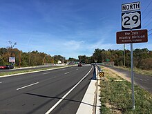
State Route 28 in the U.S. state of Virginia is a primary state highway that traverses the counties of Loudoun, Fairfax, Prince William, and Fauquier in the U.S. state of Virginia. The route serves as a major artery in the Northern Virginia region, with it being an important two-lane highway in rural Fauquier and Prince William Counties, the main thoroughfare through Manassas and Manassas Park, and a high-capacity freeway through Fairfax and Loudoun Counties.

The Oakton Classic is an annual invitational high school marching band competition held at Oakton High School in Vienna, Virginia. The 32nd Annual Oakton Classic will be held on October 21, 2017. The George Mason University Green Machine and the Oakton High School Marching Cougars will be the exhibition bands this year.

Arcola is a census-designated place in Loudoun County, Virginia, United States. The population as of the 2010 United States Census was 233.

Stone Ridge is a census-designated place in Loudoun County, Virginia, United States. Residences use Aldie mailing addresses, and it is near Washington Dulles International Airport. The population as of the 2020 census was 15,039. Stone Ridge is a Van Metre Homes planned, mixed-use community.

<span class="mw-page-title-main">Dranesville, Virginia</span> Census-designated place in Virginia, United States

Dranesville is a census-designated place (CDP) in Fairfax County, Virginia, United States. Dranesville is located on the Leesburg Pike at its intersection with Georgetown Pike. The U.S. Census Bureau defines Dranesville as a census-designated place (CDP) with a population of 11,921 as of 2010. At the 2020 Census the population was 11,785.

Sugarland Run is a planned community and census-designated place in Loudoun County, Virginia, United States. The population at the 2010 census was 11,799. In 2020, it was estimated to be 12,956. Sugarland Run is part of the Washington metropolitan area and is 26 miles (42 km) by road northwest of Washington, D.C.

<span class="mw-page-title-main">Greenbriar, Virginia</span> Census-designated place in Virginia, United States

Greenbriar is a census-designated place in Fairfax County, Virginia, United States. The population at the 2020 census was 8,421. The community between Fairfax City and Chantilly dates from the late 1960s, when it was developed by Levitt & Sons. The community is famous for having only one road within its territory that does not start with an "M" or "P", which is Acorn Hill. A popular belief is that the roads were named after the architect's two children. One drawback for residents of the community is that with nearly identical sounding named roads in such close proximity to each other and house numbers being the same, the US Postal Service along with UPS and FedEx sometimes deliver items to the wrong house.

<span class="mw-page-title-main">McNair, Virginia</span> Census-designated place in Virginia, United States

McNair is a census-designated place located in the Oak Hill section of Fairfax County, Virginia, United States. It is directly to the east of Washington Dulles International Airport. The population as of the 2020 census was 21,598. Much of the population resides in the McNair Farms planned community. The community has a school called McNair Elementary.

<span class="mw-page-title-main">George Mason, Virginia</span> Census-designated place in Virginia, United States

George Mason is a census-designated place (CDP) in Fairfax County, Virginia, United States. The population at the 2020 census was 11,162. It consists of George Mason University and some adjacent neighborhoods to the south and southwest of the city of Fairfax, and is named for American Founding Father George Mason.

References

  1. 1 2 3 4 5 6 "Centreville CDP, Virginia". United States Census Bureau. Retrieved December 25, 2022.
  2. "U.S. Census website". United States Census Bureau . Retrieved January 31, 2008.
  3. "US Board on Geographic Names". United States Geological Survey. October 25, 2007. Retrieved January 31, 2008.
  4. "Fairfax County, Virginia". United States Census Bureau. Retrieved November 6, 2021.
  5. William Carr Lane obtained an ordinary (tavern) license in 1768, Loudoun County Court Order Book of 1768.
  6. Virginia Gazette, Publisher: Rind, p.2, col.3, January 17, 1771 "Virginia Gazette". Archived from the original on June 27, 2009. Retrieved July 11, 2009.
  7. Town plat, Library of Virginia
  8. John Stuart Alexander, and Others, Legislative Petitions, Loudoun County, October 3, 1792, Reel 111, Box 142, Folder 39, Library of Virginia. (Second petition)
  9. John Stuart Alexander, and Others, Legislative Petitions, Fairfax County, November 20, 1790, Reel 49, Box 69, Folder 36, Library of Virginia
  10. Sweig, Donald (1992). Fairfax County Virginia: A History. Fairfax County Board of Supervisors, Fairfax, Virginia, p.45. ISBN   0-9601630-1-8
  11. "US Gazetteer files: 2010, 2000, and 1990". United States Census Bureau. February 12, 2011. Retrieved April 23, 2011.
  12. "Threaded Station Extremes". threadex.rcc-acis.org.
  13. "NowData – NOAA Online Weather Data". National Oceanic and Atmospheric Administration . Retrieved May 24, 2021.
  14. "Summary of Monthly Normals 1991–2020". National Oceanic and Atmospheric Administration. Retrieved May 4, 2021.
  15. "WMO Climate Normals for WASHINGTON DC/NATIONAL ARPT VA 1961–1990". National Oceanic and Atmospheric Administration. Retrieved July 18, 2020.
  16. Rogers, Matt (April 1, 2015). "April outlook: Winter be gone! First half of month looks warmer than average". The Washington Post . Retrieved May 24, 2021. For reference, here are the 30-year climatology benchmarks for Reagan National Airport for April, along with our projections for the coming month:...Average snowfall: Trace; Forecast: 0 to trace
  17. "Washington, DC - Detailed climate information and monthly weather forecast". Weather Atlas. Yu Media Group. Retrieved June 29, 2019.
  18. "CENSUS OF POPULATION AND HOUSING (1790–2000)". U.S. Census Bureau . Retrieved July 17, 2010.
  19. Population recorded when the census tabulated figures of unincorporated places for the first time. 1880 Census of Population
  20. Layla Wilder, Loudoun Times, Frey OKs Route 28 median Archived January 28, 2008, at the Wayback Machine April 12, 2007; accessed October 13, 2007
  21. "CHEM 321 - Quantitative Chemical Analysis". gmu.edu. Archived from the original on September 26, 2015. Retrieved August 18, 2015.
  22. "Ludacris tells Lindsay Czarniak that he attended Centreville High School for a year". Washington Post.
  23. "Scott Secules". Pro-Football-Reference.com. Retrieved August 18, 2015.
  24. BaseballAmerica – stats for Brandon Snyder
  25. "Library Branches." Fairfax County Public Library. Retrieved on October 21, 2009.
  26. "Centreville CDP, Virginia [ permanent dead link ]." U.S. Census Bureau. Retrieved on October 21, 2009.