
Socorro County is a county in the U.S. state of New Mexico. As of the 2010 census, the population was 17,866. The county seat is Socorro. The county was formed in 1852 as one of the original nine counties of New Mexico Territory. Socorro was originally the name given to a Native American village by Don Juan de Oñate in 1598. Having received vitally needed food and assistance from the native population, Oñate named the pueblo Socorro.
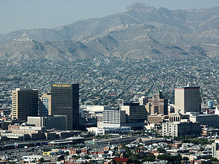
El Paso County is the westernmost county in the U.S. state of Texas. As of the 2020 census, the population was 865,657, making it the ninth-most populous county in the state of Texas. Its seat is the city of El Paso, the sixth-most populous city in Texas and the 22nd-most populous city in the United States. The county was created in 1850 and later organized in 1871.

Valencia County is a county in the U.S. state of New Mexico. As of the 2010 census, the population was 76,569. The county seat is Los Lunas.
Dulce is a census-designated place (CDP) in Rio Arriba County, New Mexico, United States. The population was 2,743 at the 2010 census, almost entirely Native American. It is the largest community and tribal headquarters of the Jicarilla Apache Reservation.
Alamo is a census-designated place (CDP) in Socorro County, New Mexico, United States. The population was 1,085 at the 2010 census. It is the largest community on the Alamo Navajo Indian Reservation.

Socorro is a city in El Paso County, Texas, United States. It is located on the north bank of the Rio Grande southeast of El Paso, and on the border of Mexico. El Paso adjoins it on the west and the smaller city of San Elizario on the southeast; small unincorporated areas of El Paso County separate it from the nearby municipalities of Horizon City to the north and Clint to the east. As of the 2020 census, the city population was 34,306. By the 2010 census, the number had grown to 32,013. As of July 1, 2019, the population estimate for the city from the U.S. Census was 34,370. It is part of the El Paso Metropolitan Statistical Area. The city is El Paso County's second-largest municipality, after El Paso. It has a council-manager type of government with five city council members. Socorro is the 93rd-largest community in Texas.

San Antonio is a census-designated place in Socorro County, New Mexico, United States, roughly in the center of the state, on the Rio Grande. The entire population of the county is approximately 18,000.
Lemitar is a census-designated place in Socorro County, New Mexico, United States. Its population was 330 as of the 2010 census. Lemitar has a post office with ZIP code 87823. Exit 156 on Interstate 25 serves the community.
Chical is a census-designated place in Valencia County, New Mexico, United States. Its population was 107 as of the 2010 census.
Madrone is a census-designated place in Valencia County, New Mexico, United States. Its population was 707 as of the 2010 census. New Mexico State Road 304 passes through the community.
Pueblitos is a census-designated place in Valencia County, New Mexico, United States. Its population was 794 as of the 2010 census. New Mexico State Road 116 passes through the community.
Alamillo is an unincorporated community and census-designated place in Socorro County, New Mexico, United States. Its population was 102 as of the 2010 census. Interstate 25 passes through the community.
Escondida is an unincorporated community and census-designated place in Socorro County, New Mexico, United States. Its population was 47 as of the 2010 census. Interstate 25 passes through the community.
Las Nutrias is an unincorporated community and census-designated place in Socorro County, New Mexico, United States. Its population was 149 as of the 2010 census. New Mexico State Road 304 passes through the community.
Jacona is an unincorporated community and census-designated place in Santa Fe County, New Mexico, United States. Its population was 412 as of the 2010 census.
San Pedro is an unincorporated community and census-designated place in Santa Fe County, New Mexico, United States. Its population was 184 as of the 2010 census. New Mexico State Road 344 passes through the community.
Chamita is a census-designated place in Rio Arriba County, New Mexico, United States. Its population was 870 as of the 2010 census. New Mexico State Road 74 passes through the community. During its earlier years, the community was known as San Pedro De Chamita and served as the first county seat for Rio Arriba county.
El Duende is an unincorporated community and census-designated place in Rio Arriba County, New Mexico, United States. Its population was 707 as of the 2010 census. The community is located at the junction of U.S. Routes 84/285 and New Mexico State Road 74. El Duende means "the dwarf" in Spanish, but how and why it adopted this moniker is unknown.
Lyden is an unincorporated community and census-designated place in Rio Arriba County, New Mexico, United States. Its population was 245 as of the 2010 census. The community is located on the west bank of the Rio Grande. It was formerly known as "El Bosque." A post office operated in Lyden between 1902 and 1957.
Pueblito is an unincorporated community and census-designated place in Rio Arriba County, New Mexico, United States. Its population was 91 as of the 2010 census. Pueblito was settled in the 1850s by former residents of La Parida, which was flooded by the Rio Grande.

