Champaner-Pavagadh Archaeological Park

Last updated

Champaner-Pavagadh Archaeological Park
UNESCO World Heritage Site
Jain Temple, Pavagadh (cropped).jpg
Location Panchmahal district, Gujarat, India
Criteria Cultural: (iii), (iv), (v), (vi)
Reference 1101
Inscription2004 (28th Session)
Area1,328.89 ha (3,283.8 acres)
Buffer zone2,911.74 ha (7,195.1 acres)
Coordinates 22°29′N73°32′E / 22.483°N 73.533°E / 22.483; 73.533
Gujarat relief map.svg
Red pog.svg
Location of Champaner-Pavagadh Archaeological Park in Gujarat
India relief location map.jpg
Red pog.svg
Champaner-Pavagadh Archaeological Park (India)
South Asia non political, with rivers.jpg
Red pog.svg
Champaner-Pavagadh Archaeological Park (South Asia)

Champaner-Pavagadh Archaeological Park, a UNESCO World Heritage Site, is located in Panchmahal district in Gujarat, India. It is located around the historical city of Champaner, a city which was founded by Vanraj Chavda, the most prominent king of the Chavda Dynasty, in the eighth century. He named it after the name of his friend and general Champa, also known later as Champaraj. The heritage site is studded with forts with bastions starting from the hills of Pavagadh, and extending into the city of Champaner. The park's landscape includes archaeological, historic and living cultural heritage monuments such as chalcolithic sites, a hill fortress of an early Hindu capital, and remains of the 16th-century capital of the state of Gujarat. There are palaces, entrance gates and arches, mosques, tombs and temples, residential complexes, agricultural structures and water installations such as stepwells and tanks, dating from the eighth to the 14th centuries. The Kalika Mata Temple, located on top of the 800 metres (2,600 ft) high Pavagadh Hill, is an important Hindu shrine in the region, attracting large numbers of pilgrims throughout the year. [1] [2] [3]

Contents

The transition between Hindu and Muslim culture and architecture in the late 15th to early 16th century is documented in the park, particularly the early Islamic and pre-Mughal city that has remained without any change. [4] It was inscribed by UNESCO as a World Heritage Site in 2004. [5]

Geography

Map of the Archiological Park SVG MAP OF CHAMPANER ARCH PARK.svg
Map of the Archiological Park
Path on Pavagadh Hill Path on Pavadagh hill.JPG
Path on Pavagadh Hill

The Champaner-Pavagadh heritage site is spread over an area of more than 1,329 hectares (3,280 acres) with a buffer zone of 2,812 hectares (6,950 acres). [1] In addition to the Primary Heritage Zone of 983.27 hectares (2,429.7 acres), there are several other sites which include: Kabutarkhana, Maqbara, Maqbara Mandvi, Maqbara near Patidar Village, Malik Sandal Ni Vav, Hathikhana, Sindh Mata, Sikander Ka Reuza, Babakhan Ki Dargah, Nau Kuan Sat Vavdi, and Chandrakala Vav. The site is 50 kilometres (31 mi) east of Baroda and 42 miles (68 km) south of Godhra, whose history is recorded from the second century AD and which has many religious monuments of Gujarati Sultans (of Turkish descent), Rajputs, and Jains. It includes the Palace of Mahmud Begada, grandson of Ahmed Shah, who founded Ahmedabad City, Jama Masjid and other mosques. [6] The setting is undulating hillocks and plateaus. There are steep rock exposures formed by ancient volcanic eruptions and lava flows.

Champaner is located at 22°30′N73°30′E / 22.500°N 73.500°E / 22.500; 73.500 , about 1 mile (1.6 km) to the south of Pavagadh Hill. Pavagadh Hill rises to a height of 800 metres (2,600 ft), has a geological setting of reddish-yellow stone, and is considered to be one of the oldest rock formations in India. [1] [2] [6] The highest point of the hill presents an undulating forested topography in the direction of Jambughoda. The Pavagadh Hill has a historical fort where the ancient Kalika Mata Temple is situated. The path to the summit passes through many old gates and cuts through staircase-like natural ledges of rock with precipitous sides. Midway up this path is a flat area strewn with boulders. Above this point there is a very steep scarp with a marble temple and two lantern towers. [7]

History

Oil painting on paper, Champaner, 1879 'Champaneer, near Baroda, India. Febr. 1879'.jpg
Oil painting on paper, Champaner, 1879
Ruined tomb at Champaner, 1893 Tomb at Champaner Gujarat India AD 1500.jpg
Ruined tomb at Champaner, 1893

Early history

Judging by early archaeological remains and according to records, the area had already been inhabited in the chalcolithic period; however, it remained neglected until approximately 400 AD. The history also reports a local legend that the divinity of the hills was derived from the right toe of the goddess Kalika, which had apparently fallen on the hill. [2]

Champaner is named after Champa Bhil, a last Bhil king of Champaner. [8] Champa Bhil built Champaner Fort [9] He also established this city during the rule of Vanraj Chavda of Anhilwad Patan (from 746 to 806 AD). In the eleventh century, Ram Gaur Tuar ruled, and Champaner was under the Anhilwad until 1297 or so when they were defeated by Alauddin Khalji, who made it their stronghold. During this period, the Chauhan Rajput had also settled in Champaner. The Pavagadh Hill was where the Solanki kings and Khichi Chauhans built fortresses and ruled from. However, they lost their authority in Champaner in 1484.

In 1418 and in about 1450, Khichis managed to fight off their neighbour, Rao of Idar, and the Muslim rulers of Ahmedabad, thanks to the protection provided by the hill. However, in 1483, when Mahmud Begada's captain, Malik Asad, was raiding through Champaner, he was attacked and killed by Raval Jaisingh. What ensued in the following years was the complete defeat of the Rajputs by Sultan Begada. The hill was surrounded and the fort held under siege for more than a year and was finally captured on 17 November 1484, when Kivamul Mulk and Malik Ayaz Sultani penetrated the walls and broke the main gate, destroyed the army and injured the leaders of the Rajput . Raval Jaisingh was wounded and for six months was given amnesty but was then killed since he refused to convert to Islam.[ citation needed ]

Pavadagh Hill Top of Pavadagh hill.JPG
Pavadagh Hill

Raval's son, however, converted to Islam and was made a noble with the title "Nizam-ul-Mulk". After the fort was seized, Mahmud renamed the city "Muhmudabad Champaner". It was during this period that Mahmud laid the foundation stone for his mosque. He built elaborate ornate structures, fortified both the forts, made the hill fort his Mauliya (meaning Lord of the Hill) and his citadel over a period of 23 years and eventually moved his capital from Ahmadabad to Champaner. [4]

During this period, Champaner was famous for mangoes, sandalwood trees (used then for house building and sword blades), and colourful silks. Merchants and craftsmen prospered. Mahmud died in 1511 and his successors continued to rule from Champaner until the death of Bahadur Shah (1536). The city of Champaner had been very well planned with streets and whitewashed stone houses. In 1526, young Sikander Shah died and Bahadur Shah became the next ruler of Champaner.[ citation needed ] In 1535, the Mughal Emperor Humayun invaded Champaner and looted the coffers. Upon Bahadur's death in 1536, the capital and the court shifted back to Ahmadabad. The city fell into rapid decline, was largely abandoned and for several centuries was neglected and almost deserted. [4]

Later history

General view of the Nagina Masjid, 1885 General view of the Nagina Masjid, Champaner.jpg
General view of the Nagina Masjid, 1885

The British visited the town of Champaner in 1803, at which time there were only 500 people residing there. The old city was in ruins and wildly overgrown. They re-founded it and it became a great exporter of silk, with facilities for washing and preparing raw silk. However, a cholera epidemic reduced the population to 400 families by 1812. When the British finally usurped the area on 13 July 1829, it was almost deserted; efforts at that time to populate the place by inducting cultivators with an incentive of Rs 1260 to develop the lands at that time also failed. In 1879, a few Bhil and Naikda tribes resided there, but over the next few years, it became well known in India for its rulers and the monuments left behind by them [10]

In the last decade the site has received attention by archaeologists and Heritage Trusts working in the area to develop it into a tourist attraction and a World Heritage Site. The Baroda Heritage Trust took the initiative in this direction and carried out a landscape study of the former urban centre. A Master Plan for an archaeological park was developed for Champaner City and Pavagarh as a cultural sanctuary, and the Archaeological Survey of India, supported by the Baroda Heritage Trust, submitted a proposal to UNESCO to declare the site a World Heritage Site. In July 2004, UNESCO approved the proposal and inscribed the site on the World Heritage List with the justification of its "joint significance as a living Hindu pilgrimage center, its cluster of Jain temples, its remarkable preserved medieval urban fabric, its exquisite sandstone-carved mosques and tombs and its intangible heritage values". [11] Tourism in the area was affected by the Godhra Hindu-Muslim riots, resulting in conflicting interests in developing infrastructure such as roads, ropeway and accommodation facilities for the pilgrims and tourists visiting the various monuments in this site. [12]

City planning

Remaining at the site are the Royal precincts within fortified walls, the entrance gate or the city gate, the mosque outside the fortifications, the royal walkway leading into the palace, and the second enclosure consisting of unexplored Jahanpanah. [13] The urban planning of the city reveals well laid and paved streets which lead to the city centre. The residential area consists of houses of both rich and poor; rich people's houses are built with scenic gardens and water channels. Public parks and pavilions surround the housing complex. However, temples, mosques, and tombs are mostly concentrated in the Pavagarh Hills. The walk up the hill from the plains is called the Patha (pilgrim's route); considered to be the "soul of Champaner", it has thousands of steps and is embellished with ornamental and essential structures.[ citation needed ]

Rainwater harvesting

One of the innovative features of the two historic monuments centres was the development of methods for harvesting rainwater, in the form of tanks or ponds in the Pavagadh hills (called the "hill of hundred pools") and innumerable wells in the city of Champaran, which was nicknamed "city of thousand wells". The Vishamitri River is the only stream that rises from the Pavgadh hills, and was tapped for feeding wells in Champaner and tanks in Pavagadh. The tanks served the pilgrims and other utilitarian, recreational, spiritual and aesthetic needs. Some of the tanks were built by constructing embankments and diverting the stored water into stone cisterns. Some of the famous water structures are: the Ganga, Yamuna and Saraswathi Kunds (in the Mauliya plateau); the Wada Talao, the largest water tank fed by rivulets located on the eastern part of the city; the innovative Gaben Shah tank; the exquisitely ornamented helical stepwells such as in the public gardens and at the entrance to the city, and the Royal summer pavilions. The water channel in the house of a noble, called the "Amir’s Manzil", is cited as a reflection of the "superb workmanship of water structures built by those responsible for the palatine and religious architecture of Champaner". [13]

Monuments

Eastern fortress gate Champaner eastern gate.jpg
Eastern fortress gate
Jain temple 05.jpg

There are eleven different types of buildings at Champaner-Pavagadh, including mosques, temples, granaries, tombs, wells, walls, and terraces. [14] The monuments are situated at the foot of and around the Pavagadh hill. The Heritage Trust of Baroda lists 114 monuments in the area, of which only 39 monuments are maintained by the Archaeological Survey of India, due to limited funding. [13] The Forest Department owns 94% of the land here, while the temple trusts and other sectarian establishments provide facilities for boarding and lodging to the pilgrims and tourists. On the southern side near the foot of the hill some dilapidated houses and the foundations of Jain temples can also be seen. [13]

The monuments include: [15]

Champaner
Pavagad hill

Fortresses and walls

Citadel walls. Champaner citadel walls.jpg
Citadel walls.

The fortress built by the Solanki kings of Gujarat was further fortified by Khichi Chauhans. In 1484, Sultan Mahmud Begadah captured the fort and renamed it Muhammadabad Champaner. The fortifications start on the Mauliya plateau, which is situated on the hill and ends on the plains. They are very large and are built with sandstone walls connected with bastions at intervals and have elegant balconies. [6] There are several gates in the fortifications and the enclosed area within also have barracks and jails. [3] The west gate has fortifications running from the ridge to the north built of brick and cement, followed by a freely laid stone wall for about a mile, then followed by a second line of old wall (of 30 feet (9.1 m) height) which extends 220 yards (200 m) and rises to join the first line (known as atak) of fortifications on the hill. The huge wall of free stone is known as Bigada's wall, and encloses the Jahapanah (the world shelter) and the Bhadar or the citadel of Mahmudabad Champaner; the area enclosed by this fortification is 1 mile (1.6 km) long and 280 yards (260 m) wide. [3] A rectangular building at the approach to the citadel is a guard room of size 150 feet (46 m)x1120 feet (37 m) with double gates, which has windows made of stone that are embellished with intricate carvings. Shikari Kot or Hunters Fort is located to the east of the Citadel. The Bada Talao or the Great Lake is next to the ruins of the palace.[ citation needed ]

Temples

The earliest temple on Pavagadh hill in the Mauliya plateau is dated to the 10th–11th century and is dedicated to Lakulish. However, the temple is in ruins, with only the gudha mandapa (sanctum sanctorum) and Ardha mandapa part of the antarala now present. Lakulish, Dakshinmurthi, Brahma, Vishnu, Gajendramoksha, various forms of Shiva, Indra, seated Ambika and Surasundaris are the images seen in this temple. [16] The temple was built in the Hindu temple architecture style of architecture with garbhagriha, mandapa and an entrance porch. [6] It had ornate decorations, mostly consisting of stone carvings. [6] While this oldest temple is in a dilapidated condition and not in use, all the other temples are used as places of worship. They have ornate decorations, mostly stone carvings. [6]

Jain temples, Pavagadh Jain Temple, Pavagadh (cropped).jpg
Jain temples, Pavagadh

The temples of the Jain religion at Pavagadh are also noteworthy. They are of three different groups: The first consists of the Bhavanaderi temples near Naqqarkhana gate called the Navalakka temples, the second group is in honour of the Tirthankaras Suparshvanatha and Chandraprabha and the third group, situated on the southeast of Pavagarh Hill (Mataji's cliff), is near the Pārśva temple next to the Dudhia tank. These temples are deduced to have been constructed in the 14th–15th centuries on the basis of "[their] stylistic and architectural features". Elaborately carved seated and standing images of the Jain pantheon are seen on the outer walls of the temples. The Garbabrihas are enshrined with beautiful stone images of Tirthankaras in these temples. All the temples have been renovated over time. [16]

The most visited temple on the hill is the Kalika Mata Temple. [2] It has three images of goddesses: the central image is of Kalika Mata, flanked by Kali on the right and Bahuchara Mata on the left. The spire of this temple carries a shrine of Sadanandsha pir, a Muslim saint held in great reverence in the region. It is the third of the major Shakti Peethas of Gujarat and is known for tantric worship. [17] It is connected by a mono-cable ropeway 740 metres (2,430 ft) in length which can carry 1200 people per hour and is stated to be the country's highest ropeway. [18] On Chaitra ashtami, during navratri (nine-day festival), a fair is held at the Kalika Mata temple which is attended by thousands of devotees.[ citation needed ] The ruins of Patai Raval's palace can be seen on the way to the temple.

Mosques

Jami Masjid CHAMPNER GUJARAT.JPG
Jami Masjid
Lili Gumbaz Masjid Champaner, Lila Gumbaj Ki Masjid (9840188055).jpg
Lili Gumbaz Masjid
Kevada Masjid Kevda Masjid 07.jpg
Kevada Masjid
Sahar ki Masjid Sahar ki Masjid, champaner, Gujarat.JPG
Sahar ki Masjid

Among the five mosques in very good condition, the Jami Masjid (also spelled "Jama Masjid") near the east gate, built by Sultan Begada, is one of the most notable among the 114 monuments listed by the Baroda Heritage Trust. It has a blend of Hindu and Muslim architecture preserving the Islamic ethos and with its elegant interiors is considered one of the finest mosques in Western India. [13] The masjid is built over a high plinth, has a central dome, two minarets each 30 metres (98 ft) high, 172 pillars, seven mihrabs and ornately carved entry gates fitted with stone jalis. [4] The Mughal architecture is said to have drawn from the architecture of the Sultanates, which is a blend of Hindu religious connotations and workmanship with Muslim ethos; the large domes are indicative of such a mix. [2] [3] In the Jami Masjid, the ornamentation of the surface areas of the mosque and tomb consists of symbols of motifs of the Sun, diamonds, pots and vines, and lotus insignia which were used in the earlier temples. This mosque has three mural plaques, in oblong shape, one at the top of the pulpit and the other two on the sides with engravings of hymns from the Koran. Of the two minarets, one was damaged by an intentional gun firing in 1812 by Patankar, a Scindia Governor. [13]

Other notable mosques in the heritage area are: the Kevada Masjid, the Ek Minarka Masjid (single dome mosque); the Panch Mahuda ka masjid (five-domed mosque) in a forested area; the Shehrka Masjid (city mosque), an elegant structure located inside the citadel; and the Nagina Masjid (jewel mosque), about 0.75 miles (1.21 km) to the south of the citadel, built with pure white stone; a stepwell decorated with arches is close to this mosque. Tombs have been built adjacent to mosques, invariably to a square plan with columns and domes erected over them, and also embellished with decorations. [2] The tomb of Sikander Shah seen near Halol is a simple single storied building in Muslim architectural style. The shrine of Khon pir, a saint, a colourful tomb, was a place of worship of the weaver community (Muslims known as Tais) of Champaner.[ citation needed ]

Palaces

Kabutarkhana Pavilion Kabutarkhana Pavilion Champaner 02.JPG
Kabutarkhana Pavilion

The custom house was probably used as a guard room. It is well planned in a square shape with five rows of arches and five equal colonnaded aisles. From this location to the east gate, the view of present-day Champaner consists of shabby houses on a lone street.[ citation needed ] Kabutarkhana Pavilion is situated on the north bank of Bada Talao near Khajuri Masjid. [19] Another building with columns is also located on the Pavagadh Hill, above the roof of the Mahakali temple.[ citation needed ]

Related Research Articles

Mahmud Begada or Mahmud Shah I was the most prominent Sultan of the Gujarat Sultanate. Raised to the throne at young age, he successfully captured Pavagadh and Junagadh forts in battles which gave him his name Begada. He established Champaner as the capital.

Champaner is a historical town in the state of Gujarat, in western India. It is located in Panchmahal district, 47 kilometres from the city of Vadodara. The city was briefly the capital of the Sultanate of Gujarat.At an early period Chámpáner was the seat of a Bhil dynasty. Champaner was founded by King Champa Bhil.

<span class="mw-page-title-main">Dabhoi</span> Town in Gujarat, India

Dabhoi is a town and a municipality in the Vadodara district in the state of Gujarat, India.

<span class="mw-page-title-main">Indo-Islamic architecture</span> Islamic architecture in Indian subcontinent

Indo-Islamic architecture is the architecture of the Indian subcontinent produced by and for Islamic patrons and purposes. Despite an initial Arab presence in Sindh, the development of Indo-Islamic architecture began in earnest with the establishment of Delhi as the capital of the Ghurid dynasty in 1193. Succeeding the Ghurids was the Delhi Sultanate, a series of Central Asian dynasties that consolidated much of North, East, and Central India, and later by the Mughal Empire during the early 16th century. Both of these dynasties introduced Islamic architecture and art styles from West Asia into the Indian subcontinent.

<span class="mw-page-title-main">Pavagadh</span> Place in Gujarat, India

Pavagadh is a municipal operated region in Panchmahal district about 46 kilometres (29 mi) away from Vadodara in Gujarat state in western India. It is known for a famous Mahakali temple which is one of the 51 Shaktipeeths and draws thousands of pilgrims every day. The area of this locality Champaner-Pavagadh Archaeological Park was inscribed by UNESCO as a World Heritage Site in 2004.

<span class="mw-page-title-main">Gujarat Sultanate</span> Late medieval kingdom in India (1394–1573)

The Gujarat Sultanate or Sultanate of Guzerat was a late medieval Indian kingdom in Western India, primarily in the present-day state of Gujarat. The kingdom was established in 1394 when Muzaffar Shah I, the Governor of Gujarat, declared independence from the Tughlaq dynasty of Delhi.

<span class="mw-page-title-main">Jama Mosque, Ahmedabad</span> Mosque in Ahmedabad, Gujarat, India

Jama Masjid, also known as Jumah Mosque or Jami' Masjid, is a mosque in Ahmedabad, Gujarat, India. It was built in 1424 during the reign of Ahmad Shah I. The inscription on the central mihrab commemorates the inauguration of the mosque on the 1st Safar A.H. 827 or January 4, 1424 A.D. by Sultan Ahmad Shah I. The mosque lies in the old walled city, and it is situated outside Bhadra Fort area. The old walled city is divided into separate quarters or pols, and the Jami' Masjid is found on the Gandhi Road. Along the south side of the road, the mosque is a short distance beyond the Teen Darwaza or Tripolia Gate.

<span class="mw-page-title-main">Kalika Mata Temple, Pavagadh</span> Hindu temple in India

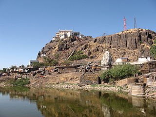
Mahakali Mata Temple is a Hindu goddess temple complex and pilgrim centre at the summit of Pavagadh Hill in Panchmahal District, India, with in the Champaner-Pavagadh Archaeological Park. It dates from the 10th or 11th centuries. The temple has three images of goddesses: the central image is of Mahakali Mata, flanked by Kali on the right and Bahucharamata on the left. On Chitra sud 8, a fair is held at the temple which is attended by thousands of devotees. The temple is the site of one of the 51 Great holy Shakti Peethas. One can easily reach the temple by ropeway.

<span class="mw-page-title-main">Pavagadh Hill</span>

Pavagadh Hill is situated within a plain in Panchmahal district, Gujarat, western India. A volcanic eruption occurred in the region approximately 500 million years ago and the etymology of Pavagadh is associated with this eruption: Pav-gadh means "one fourth hill" or "fire-hill". At its base is the historical city of Champaner, while the hill station of Pavagadh was built upon the volcanic cone itself. With Champaner, Pavagadh hill forms the Champaner-Pavagadh Archaeological Park, a UNESCO World Heritage Site which is spread over an area of more than 1,329 hectares. Known for its forts, there are also dozens of heritage structures on the hill. The site is 50 kilometres (31 mi) east of Vadodara and 68 kilometres (42 mi) south of Godhra.

<span class="mw-page-title-main">Jama Mosque, Champaner</span> Mosque in Champaner, Gujarat, India

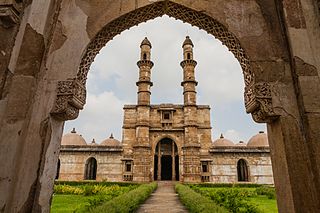
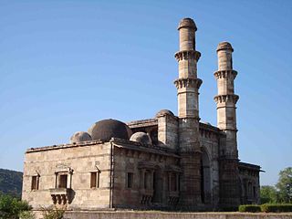
Jami Masjid in Champaner, Gujarat state, western India, is part of the Champaner-Pavagadh Archaeological Park, a UNESCO World Heritage Site, and is among the 114 monuments there which are listed by the Baroda Heritage Trust. It is located about 150 feet (46 m) east of the city walls (Jahdnpandh), near the east gate.

<span class="mw-page-title-main">Kevada Mosque</span> Mosque in Champaner, Gujarat, India

Kevada Mosque is a mosque in Champaner, Gujarat state, western India. It is part of the Champaner-Pavagadh Archaeological Park, a UNESCO World Heritage Site. The mosque has minarets, globe-like domes, and narrow stairs. According to Ruggles (2008), nature was integrated into the Kevada mosque's architecture in a way that was unusual elsewhere in the Islamic world.

<span class="mw-page-title-main">Bawaman Mosque</span> Mosque in Champaner, Gujarat, India

Bawaman Mosque is a mosque in Champaner, western India. It is situated on the western side of one of the ancient city's fort gates, within the Champaner-Pavagadh Archaeological Park of Gujarat.

<span class="mw-page-title-main">Nagina Mosque</span> Mosque in Gujarat, India

Nagina Mosque is a mosque in Champaner, Gujarat, India. It was built during the time of Mahmud Begada, in the 15th century, as were several other masjids, such as the Kevada, Bawaman, Ek Minar, Jama, Khajuri, and Shahar Ki. It has minarets, globe-like domes, and narrow stairs. It is part of the Champaner-Pavagadh Archaeological Park, a UNESCO World Heritage Site.

<span class="mw-page-title-main">Monuments of Champaner-Pavagadh Archaeological Park</span> UNESCO-recognized monuments

There are eleven different types of buildings at the UNESCO-protected Champaner-Pavagadh Archaeological Park in Gujarat, India, including mosques, temples, granaries, tombs, wells, walls, and terraces. The monuments are situated at the foot of and around the Pavagadh Hill. The Baroda Heritage Trust lists 114 monuments in the area, of which only 39 are maintained by the Archaeological Survey of India, due to limited funding. The Forest Department owns 94% of the land here, while the temple trusts and other sectarian establishments provide facilities for boarding and lodging to pilgrims and tourists. On the southern side near the foot of the hill some dilapidated houses and the foundations of Jain temples can also be seen.

<span class="mw-page-title-main">Lila Gumbaj Ki Mosque</span> Mosque in Champaner, Gujarat, India

Lila Gumbaj Ki Mosque in Champaner, Gujarat state, western India is one of the 114 monuments listed by the Baroda Heritage Trust that are part of the Champaner-Pavagadh Archaeological Park, a UNESCO World Heritage Site. It is located near the east gate of the former city.

The Architecture of Gujarat consists of architecture in the Indian state of Gujarat.

<span class="mw-page-title-main">Jumma Masjid, Uparkot</span> State protected monument of Gujarat

Jumma Masjid or Jama Masjid is a mosque in Uparkot Fort in Junagadh, Gujarat, India. The mosque was built in 15th century by converting a temple or a palace identified as Ranakdevi Mahal by local people and ASI. There is a controversy surrounding the identification of the structure.

<span class="mw-page-title-main">Pavagadh ropeway</span>

Pavagadh ropeway is a ropeway on Pavagadh hill in Pavagadh, Panchmahal district, Gujarat, India. It was opened in 1986.

<span class="mw-page-title-main">Jain temples, Pavagadh</span> Temple complex in Pavagadh Hill, Gujarat

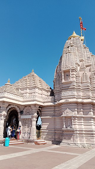
Jain temples, Pavagadh is a group of seven Jain temples located in Pavagadh Hill in the state of Gujarat. These temples are part of the UNESCO World Heritage Site of Champaner-Pavagadh Archaeological Park.

References

  1. 1 2 3 "Champaner-Pavagadh Archaeological Park". United Nations Educational, Scientific and Cultural Organization. Retrieved 24 September 2012.
  2. 1 2 3 4 5 6 "Advisory Body Evaluation, Champaner-Pavagadh (India) No 1101" (PDF). United Nations Educational, Scientific and Cultural Organization. pp. 26–29. Retrieved 24 September 2012.
  3. 1 2 3 4 "United Nations Educational, Scientific and Cultural Organization (UNESCO) Fact Sheet". United Nations Educational, Scientific and Cultural Organization. Retrieved 24 September 2012.
  4. 1 2 3 4 "Champaner-Pavagadh". Worldheritagesite.org. Archived from the original on 6 October 2012. Retrieved 23 September 2012.
  5. World heritage series - Champaner Pavagadh. New Delhi: Visual Communication. 2009. p. 5.
  6. 1 2 3 4 5 6 "Champaner-Pavagarh Archaeological Park (2004), Gujarat". National InformaticCentre (NIC) for Archaeological Survey of India (ISI). Archived from the original on 1 May 2012. Retrieved 24 September 2012.
  7. "Champaner, near Baroda, India. Febr. 1879". Online Gallery, British Library, UK. Retrieved 29 September 2012.
  8. Mishra, Phanikanta (1995). Researches in Indian Archaeology, Art, Architecture, Culture and Religion: Vijayakanta Mishra Commemorative Volume. Sundeep Prakashan. ISBN   978-81-85067-80-3.
  9. Nizami, Akhtar Hussain (1990). Survey of Kheechi Chauhan History: With Biographical Notes. Kheechi Chauhan Shodh Sansthan.
  10. Kamdar, Mira (2008). Planet India: The Turbulent Rise of the Largest Democracy and the Future of Our World. Simon and Schuster. p. 217. ISBN   978-0-7432-9686-1.
  11. Silverman & Ruggles 2008, pp. 56–57.
  12. Silverman & Ruggles 2008, pp. 59–60.
  13. 1 2 3 4 5 6 Ruggles, D. Fairchild; Silverman, Helaine (2009). Intangible Heritage Embodied. Springer. pp. 91–93, 96–97. ISBN   978-1-4419-0071-5.
  14. Documentation Update. Equitable Tourism Options. p. 141.
  15. "Historic Monuments in Gujarat". Union of Public Service Commission. Retrieved 30 September 2012.
  16. 1 2 B. Busa Goud. "Scientific Conservation of World Heritage Monuments of Champaner-Pavgadh" (PDF). UNESCO. Org. Retrieved 29 September 2012.[ permanent dead link ]
  17. Vyas, Rajnee (2006). Welcome to Gujarat. Akshara Prakashan. p. 128.
  18. Limca Book of Records. Bisleri Beverages Ltd. 1990. Retrieved 28 September 2012.
  19. India. Superintendent of Census Operations, Gujarat (1964). Panchmahals. Director, Government Print. and Stationery, Gujarat State. p. 188.

Bibliography