Historic City of Ahmadabad

Last updated

Historic City of Ahmadabad
અમદાવાદ કોટવિસ્તાર
Urban settlement
Ahmedabad 1855.jpg
Map of old Ahmedabad in 1855
Ahmedabad locator map.svg
Red pog.svg
Historic City of Ahmadabad
Location in Gujarat, India
India Gujarat location map.svg
Red pog.svg
Historic City of Ahmadabad
Historic City of Ahmadabad (Gujarat)
India location map.svg
Red pog.svg
Historic City of Ahmadabad
Historic City of Ahmadabad (India)
Coordinates: 23°1′32″N72°35′15″E / 23.02556°N 72.58750°E / 23.02556; 72.58750
CountryIndia
StateGujarat
District Ahmedabad district
CityAhmedabad
Established1411
Founded by Ahmad Shah I
Criteria Cultural: (ii), (v)
Reference 1551
Inscription2017 (41st Session)
Area535.7 ha (2.068 sq mi)
Buffer zone395 ha (1.53 sq mi)
City walls of Ahmedabad 1866 City Walls of Ahmedabad 1866.jpg
City walls of Ahmedabad 1866

The Historic City of Ahmadabad or Old Ahmedabad , the walled city of Ahmedabad in India, was founded by Ahmad Shah I of the Gujarat Sultanate in 1411. It remained the capital of the state of Gujarat for six centuries and later became the important political and commercial centre of Gujarat. Today, despite having become crowded and dilapidated, it still serves as the symbolic heart of metropolitan Ahmedabad. It was inscribed as the World Heritage City by UNESCO in July 2017. [1]

Contents

History

The earliest settlements were situated south of the current old city and on the bank of Sabarmati river. It was known as Ashaval or Ashapalli. In the 11th century, Karna of the Chaulukya dynasty made the town his capital and named it Karnavati (Karna's town), Shrinagar (prosperous city), and Rajnagar (king's town). [2]

Ahmed Shah I laid the foundation of Bhadra Fort starting from Manek Burj, the first bastion of the city in 1411 which was completed in 1413. He also established the first square of the city, Manek Chowk, both associated with the legend of Hindu saint Maneknath. His Gujarat Sultanate (1411–1573) ruled from the city until 1484. His grandson Mahmud Begada transferred capital from Ahmedabad to Muhammadabad from 1484 to 1535 but carried out second fortification of the city. Later Ahmedabad again became capital of sultanate until it fell to Mughals in 1573. During Mughal rule (1572–1707), Bhadra Fort served as the seat of Governor of Gujarat. The city flourished with addition of several settlements in and around the city. Of the population of the city no estimate has been traced. There is some estimate of the size of city in works of the time: Ferishta, the Ain-i-Akbari, and the Mirat-i-Ahmadi. According to the Ain-i-Akbari (1580), there were 360 puras, of which only eighty-four were then flourishing; according to Ferishta there were, in 1600, 360 mahalla, each surrounded by a wall ; the Mirat-i-Ahmadi in one passage says, such was once its populous state that it contained 380 puras, each pura a considerable quarter almost a city; in another passage he mentions twelve city wards and others outside, and in his detailed account of the city he mentions by name 110 suburbs of which 19 were settled under Mughal rule. German traveller Mandelslo (1638) mentioned the suburbs and dependent villages are nearly seven leagues round. [3] During Mughal and Maratha struggle (1707–1753) to control the city, the city was harmed and several suburbs were depopulated. The city walls damaged in battles and the trade was affected. The city revenue was divided between Mughal and Maratha rulers. Later during Maratha rule (1758–1817), the city revenue was divided between Peshwa and Gaekwad. These affected the economy of the city due to more extraction of taxes. In 1817, Ahmedabad fell under British Company rule which stabilized the city politically and improved the trade. The population rose from 80,000 in 1817 to about 88,000 in 1824. During the eight following years a special cess was levied on ghee and other products and at a cost of £25,000 (Rs. 2,50,000) the city walls were repaired. About the same time a cantonment was established on a site to the north of the city. The population rose (1816) to about 95,000. The remaining public funds after the walls were finished were used for municipal purposes. [4] The old city continued to be the centre of political activities during the Indian independence movement under Mahatma Gandhi.

Forts and Gates

Forts

Square in form, enclosing an area of about forty-three acres, the Bhadra fort had eight gates, three large, two in the east and one in the south-west corner; three middle-sized, two in the north and one in the south; and two small, in the west. The construction of Jama Masjid, Ahmedabad completed in 1423. As the city expanded, the city wall was expanded. So the second fortification was carried out by Mahmud Begada in 1486, the grandson of Ahmed Shah, with an outer wall 10 km (6.2 mi) in circumference and consisting of 12 gates, 189 bastions and over 6,000 battlements as described in Mirat-i-Ahmadi. [5] The city walls of second fortification, running on the west for about a mile and three quarters along the bank of the Sabarmati, and stretching east in semi-circular form, include an area of two square miles in past. [6]

Gates

Most people believe that Ahmedabad had 12 gates but some historian suggested to have 16. Later some Indologist found that Ahmedabad had 21 gates. Bhadra fort had eight gates, three large, two in the east and one in the south-west corner; three middle-sized, two in the north and one in the south; and two small, in the west. [7] In the city walls of second fort, there were eighteen gates, fifteen large and three small. Of the fifteen, one was closed, and two were added later. These gates were, beginning from the north-west corner, three in the north-wall, the Shahpur in the north-west, the Delhi in the north, and the Dariyapur in the north-east; four in the east wall, the Premabhai, a gate built by British, in the north-east, the Kalupur in the east, the Panchkuva, a gate built by British, in the east, and the Sarangpur in the south-east; four in the south wall, the Raipur and Astodiya in the south-east, and the Mahuda, the closed gate, and the Jamalpur in the south; seven in the west wall, the Khan Jahan, Raikhad and Manek in the south-west; the three citadel gates, Ganesh, Ram, and Baradari in the centre; and the Khanpur gate in the north-west. [8] [9] Two new gates, Prem Darwaja and Panchkuva Gate added by British after opening of railways in 1864. [10]

Neighbourhood

Pol area of Old Ahmedabad Pole 44.jpg
Pol area of Old Ahmedabad

Pols were the typical housing cluster of the old city with there being as many as 356 in 1872. This form of housing was established during a time of divided rule from 1738-1753 due to religious tension between Hindu and Muslims. When the city walls deteriorated and no longer provided protection from robbers, the pol gate became more important for protection. [11]

Architecture

The old city features rich wooden architecture, havelis, khadkis, and pols. The wooden architecture is exemplary of the unique heritage and culture in Ahmedabad. It signifies contributions to arts and crafts, traditions, and structure design, and is reflective of the city's occupants. The city's architecture was designed to promote a sense of community, family, and multiculturalism. This is evident in the city being home to institutions belonging to several religions including Hinduism, Islam, Christianity, and Judaism. [12]

Related Research Articles

<span class="mw-page-title-main">Ahmedabad</span> Metropolis in Gujarat, India

Ahmedabad is the most populous city in the Indian state of Gujarat. It is the administrative headquarters of the Ahmedabad district and the seat of the Gujarat High Court. Ahmedabad's population of 5,570,585 makes it the fifth-most populous city in India, and the encompassing urban agglomeration population estimated at 6,357,693 is the seventh-most populous in India. Ahmedabad is located near the banks of the Sabarmati River, 25 km (16 mi) from the capital of Gujarat, Gandhinagar, also known as its twin city.

This page provides a historical timeline of Ahmedabad, the sixth largest city in India.

Mahmud Begada or Mahmud Shah I was the most prominent Sultan of the Gujarat Sultanate. Raised to the throne at young age, he successfully captured Pavagadh and Junagadh forts in battles which gave him his name Begada. He established Champaner as the capital.

<span class="mw-page-title-main">Champaner-Pavagadh Archaeological Park</span> A UNESCO World Heritage Site located in Panchmahal district, Gujarat, India.

Champaner-Pavagadh Archaeological Park, a UNESCO World Heritage Site, is located in Panchmahal district in Gujarat, India. It is located around the historical city of Champaner, a city which was founded by Vanraj Chavda, the most prominent king of the Chavda Dynasty, in the eighth century. He named it after the name of his friend and general Champa, also known later as Champaraj. The heritage site is studded with forts with bastions starting from the hills of Pavagadh, and extending into the city of Champaner. The park's landscape includes archaeological, historic and living cultural heritage monuments such as chalcolithic sites, a hill fortress of an early Hindu capital, and remains of the 16th-century capital of the state of Gujarat. There are palaces, entrance gates and arches, mosques, tombs and temples, residential complexes, agricultural structures and water installations such as stepwells and tanks, dating from the eighth to the 14th centuries. The Kalika Mata Temple, located on top of the 800 metres (2,600 ft) high Pavagadh Hill, is an important Hindu shrine in the region, attracting large numbers of pilgrims throughout the year.

The history of Gujarat began with Stone Age settlements followed by Chalcolithic and Bronze Age settlements like Indus Valley civilisation. Gujarat's coastal cities, chiefly Bharuch, served as ports and trading centers in the Nanda, Maurya, Satavahana and Gupta empires as well as during the Western Kshatrapas period. After the fall of the Gupta empire in the 6th century, Gujarat flourished as an independent Hindu-Buddhist state. The Maitraka dynasty, descended from a Gupta general, ruled from the 6th to the 8th centuries from their capital at Vallabhi, although they were ruled briefly by Harsha during the 7th century. The Arab rulers of Sindh sacked Vallabhi in 770, bringing the Maitraka dynasty to an end. The Gurjara-Pratihara Empire ruled Gujarat after from the 8th to 10th centuries. While the region also came under the control of the Rashtrakuta Empire. In 775 the first Parsi (Zoroastrian) refugees arrived in Gujarat from Greater Iran.

<span class="mw-page-title-main">Pol (housing)</span>

A pol in India is a housing cluster which comprises many families of a particular group, linked by caste, profession, or religion. Pols are typical of urban centres in Gujarat especially of Old Ahmedabad.

Ahmedabad is the largest city in the state of Gujarat. It is located in western India on the banks of the River Sabarmati. The city served as political as well as economical capital of the region since its establishment. The earliest settlement can be recorded around the 12th century under Chaulukya dynasty rule. The present city was founded on 26 February 1411 and announced as the capital on 4 March 1411 by Ahmed Shah I of Gujarat Sultanate as a new capital. Under the rule of sultanate (1411–1511) the city prospered followed by decline (1511–1572) when the capital was transferred to Champaner. For next 135 years (1572–1707), the city renewed greatness under the early rulers of Mughal Empire. The city suffered due to political instability (1707–1817) under late Mughal rulers followed by joint rule between Maratha and Mughal. The city further suffered following joint Maratha rule. The city again progressed when politically stabilized when British East India Company established the rule in the city (1818–1857). The city further renewed growth when it gain political freedom by establishment of municipality and opening of railway under British crown rule (1857–1947). Following arrival of Mahatma Gandhi in 1915, the city became centre stage of Indian independence movement. Many activists like Sardar Patel served the municipality of the city before taking part in the movement. After independence, the city was a part of Bombay state. When Gujarat was carved out in 1960, it again became the capital of the state until establishment of Gandhinagar in 1965. Ahmedabad is also the cultural and economical centre of Gujarat and the seventh largest city of India.

<span class="mw-page-title-main">Sidi Bashir Mosque</span> Former mosque in Mumbai, Maharashtra, India

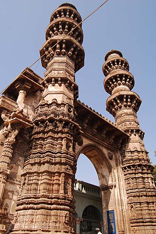
Sidi Bashir Mosque is a former mosque in the city of Ahmedabad, Gujarat, India. Only the central gateway and two minarets survive; they are known as the Jhulta Minar or Shaking Minarets.

<span class="mw-page-title-main">Gujarat Sultanate</span> Late medieval kingdom in India (1394–1573)

The Gujarat Sultanate or Sultanate of Guzerat was a late medieval Indian kingdom in Western India, primarily in the present-day state of Gujarat. The kingdom was established in 1394 when Muzaffar Shah I, the Governor of Gujarat, declared independence from the Tughlaq dynasty of Delhi.

<span class="mw-page-title-main">Ahmad Shah I</span> Sultan of Gujarat from 1411–1442

Ahmad Shah I, born Ahmad Khan, was a ruler of the Muzaffarid dynasty, who reigned over the Gujarat Sultanate from 1411 until his death in 1442. He was the grandson of Sultan Muzaffar Shah, founder of the dynasty.

<span class="mw-page-title-main">Jama Mosque, Ahmedabad</span> Mosque in Ahmedabad, Gujarat, India

Jama Masjid, also known as Jumah Mosque or Jami' Masjid, is a mosque in Ahmedabad, Gujarat, India. It and was built in 1424 during the reign of Ahmad Shah I. The inscription on the central mihrab commemorates the inauguration of the mosque on the 1st Safar A.H. 827 or January 4, 1424 A.D. by Sultan Ahmad Shah I. The mosque lies in the old walled city, and it is situated outside Bhadra Fort area. The old walled city is divided into separate quarters or pols, and the Jami' Masjid is found on the Gandhi Road. Along the south side of the road, the mosque is a short distance beyond the Teen Darwaza or Tripolia Gate.
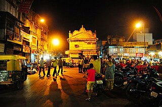
<span class="mw-page-title-main">Manek Chowk (Ahmedabad)</span> Prominent city square in Ahmedabad, India

Manek Chowk

<span class="mw-page-title-main">Bhadra Fort</span>

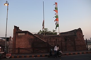
Bhadra Fort is situated in the walled city area of Ahmedabad, India. It was built by Ahmad Shah I in 1411. With its well carved royal palaces, mosques, gates and open spaces, it was renovated in 2014 by the Amdavad Municipal Corporation (AMC) and the Archaeological Survey of India (ASI) as a cultural centre for the city.

<span class="mw-page-title-main">Gaekwad Haveli</span> Haveli with fortification in Ahmedabad, India

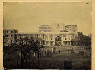
Gaekwad Haveli is a historical haveli building in Ahmedabad. It was built in 1738. It was used as a seat of Gaekwad during Maratha rule in Ahmedabad. It was later converted into barracks and arsenal under British rule. Later it was used as railway depot and police crime branch headquarters. It was restored in 2014.

<span class="mw-page-title-main">Shah-e-Alam's Roza</span>

Shah-e-Alam's Tomb and Mosque, also known as Rasulabad Dargah or Shah Alam no Rozo, is a medieval mosque and tomb complex (Roza) in Shah Alam area of Ahmedabad, India.

Malik Isan's Mosque, also known as Isanpur Mosque or Gumle Masjid, is a medieval mosque in Isanpur area of Ahmedabad, India.

<span class="mw-page-title-main">Maneknath</span>

Baba Maneknath was 15th century legendary Hindu saint who lived on the banks of Sabarmati river near present city of Ahmedabad, Gujarat, India.

<span class="mw-page-title-main">Manek Burj</span> Bastion of the city wall in Ahmedabad, India

Manek Burj, also spelled Manek Buraj is the foundation bastion of Bhadra Fort in the old city of Ahmedabad, Gujarat, India. The Burj is associated with legendary saint Maneknath.

<span class="mw-page-title-main">Teen Darwaza</span> Gateway in Ahmedabad, India

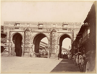
Teen Darwaza is a historical gateway on the east of Bhadra Fort, Ahmedabad, India. Completed in 1415, it is associated with historical as well as legendary events. The gates are featured in the logo of Ahmedabad Municipal Corporation.

<span class="mw-page-title-main">Gates of Ahmedabad</span>

The Darwaja or Gates of Ahmedabad were built during different times starting from 1411 as the entrances to the walled city of Ahmedabad, Gujarat, India.

References

  1. "Ahmedabad takes giant leap, becomes India's first World Heritage City". The Times of India. Retrieved 15 July 2017.
  2. Google Books 2015, p. 249.
  3. Google Books 2015, p. 252-253.
  4. Google Books 2015, pp. 260–261.
  5. G. Kuppuram (1988). India through the ages: history, art, culture, and religion. Vol. 2. Sundeep Prakashan. p. 739. ISBN   9788185067094.
  6. Google Books 2015, p. 248.
  7. Rajput, Vipul; Patel, Dilip (8 February 2010). "City's Lost Gates". Ahmedabad Mirror . AM. Archived from the original on 10 April 2013. Retrieved 12 February 2013.
  8. Pandya, Yatin (23 January 2011). "Ahmedabad gates: Residue of past or the pride of the present?". DNA. Retrieved 11 January 2015.
  9. Gazetteer of the Bombay Presidency: Ahmedabad. Government Central Press. 1879. pp. 273–277.
  10. Google Books 2015, p. 262.
  11. Google Books 2015, p. 294-295.
  12. Centre, UNESCO World Heritage. "Historic City of Ahmadabad". UNESCO World Heritage Centre. Retrieved 6 December 2022.

Bibliography