
Barrackpore is a city and a municipality of North 24 Parganas district in the Indian state of West Bengal. It is close to Kolkata and part of the area covered by Kolkata Metropolitan Development Authority (KMDA). It is the headquarters of the Barrackpore subdivision.
A cantonment is a military quarters. In Bangladesh, India, Pakistan and other parts of South Asia, a cantonment refers to a permanent military station. In United States military parlance, a cantonment is, essentially, "a permanent residential section of a fort or other military installation," such as Fort Cavazos.
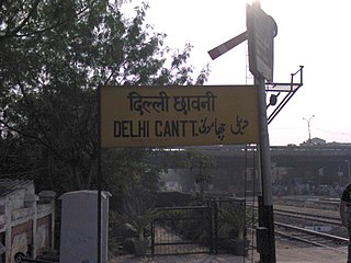
Delhi Cantonment is a Class I Cantonment Board established in 1914. The area of the Cantonment is 10,452 acres (42.30 km2) and the population of the Cantonment as per the 2011 census is 110,351.
Jalandhar Cantonment is a cantonment town in Jalandhar District in the Indian state of Punjab. The Cantonment is located between latitude 30° 18' and longitude 75° 37' on the southwest and at a distance of 2 km from Cantonment Railway Station and 5 km from City Railway Station. It is situated beside Grand Trunk Road at a distance of 89 km from Amritsar and 371 km from Delhi. It covers an area of 5.87 square miles (15.2 km²). It is on Amritsar-Delhi Broad Gauge Main Line. A Class-I airfield at Adampur is situated at a distance of 19 km. The airfield is linked with Jalandhar Cantonment by rail and road. It has a Recruiting Office responsible for enlisting the soldiers for Army, Navy and Air Force. The first Recruiting Officer who held this post until 1952 was Col. Dilbagh Singh Minhas of Jallandhar Doab.
Barrackpur Cantonment is a Town and a cantonment board of North 24 Parganas district in the Indian state of West Bengal. It also a part of the area covered by Kolkata Metropolitan Development Authority (KMDA).
Clement Town is a cantonment town in Dehradun, Dehradun district in the state of Uttarakhand, India. Clement Town is seven kilometres (4.3 mi) from the clock tower in main city of Dehradun. Saharanpur and Haridwar are 65 and 54 km respectively. It also borders Rajaji National Park and is home to several renowned institutions. Schools such as Raja Ram Mohan Roy Academy and St. Mary's are in the neighbourhood. Country singer Bobby Cash resides in Clement Town.
Danapur Cantonment or Danapur Cantt is a cantonment town in Patna District in the state of Bihar, India. Danapur is a category II cantonment, established in 1765. The board consists of 14 members including 7 elected members. Danapur Cantonment, located on the outskirts of Patna, is the second oldest cantonment in India, after Barrackpur Cantonment, West Bengal. Danapur is the regimental centre of the Bihar Regiment (BRC). It was earlier called Bankipore Cantonment. Initially, it was set up at Bankipore but later set up in the Danapur area in 1766–67.
Ferozepur Cantonment, also known as Firojpur Cantonment and Firojepur Cantonment, is a cantonment town in Firozpur district in the state of Punjab, India. It is located to the south of the city of Firozpur.
Garshyamnagar is a census town in Barrackpore I CD Block in Barrackpore subdivision in North 24 Parganas district in the state of West Bengal, India. It is a part of Kolkata Urban Agglomeration.
Ichhapur Defence Estate is a census town in Barrackpore I CD Block in Barrackpore subdivision in North 24 Parganas district in the Indian state of West Bengal. It is a part of Kolkata Urban Agglomeration.
Jetia is a census town in Barrackpore I CD Block in Barrackpore subdivision in North 24 Parganas district in the Indian state of West Bengal. It is a part of Kolkata Urban Agglomeration.
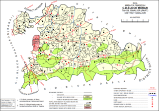
Morar Cantonment is a cantonment town in Gwalior district in the Indian state of Madhya Pradesh. It is part of an urban agglomeration together with neighbouring Gwalior. Adv. Rakesh Singh Chauhan is the longest serving Former Chairman & Vice-President of Cantonment Board Morar.
Dalhousie cantonment is a town in Chamba district in the state of Himachal Pradesh, India.
Noapara is a census town in Barrackpore I CD Block in Barrackpore subdivision of North 24 Parganas district in the Indian state of West Bengal. It is a part of Kolkata Urban Agglomeration.
A cantonment board is a civic administration body in India under control of the Ministry of Defence. The board comprises elected members besides ex-officio and nominated members as per the Cantonments Act, 2006. The term of office of a member of a board is five years. A cantonment board consists of eight elected members, three nominated military members, three ex-officio members, and one representative of the district magistrate.
Kanpur Cantonment is a military cantonment in Kanpur, Uttar Pradesh, India. The Kanpur Cantonment was established in the year 1811 and is situated on the right bank of river Ganges and is bound by Kanpur city area on the remaining three sides. Kanpur Cantonment is the largest cantonment in India, by population. The area of the Cantonment is approx. 4243.0084 acres (17 km2) out of which the Bungalow Area is 3899.1784 acres and the Civil Area is 334.83 acres. As per 2011 Census, the population of Cantonment is 108,035 which is 453rd largest city of India.
The Indian Defence Estates Service is a Civil Service in the Government of India. Its Cadre Controlling Authority (CCA) is the Ministry of Defence. Civil Services Examination conducted every year by Union Public Service Commission provides a gateway for entry into this service. The Service traces its origin to 16 December 1926 and has been constantly evolving since then. The service was initially known as the Military Lands and Cantonment Service (1926-1983), and then Defence Lands and Cantonment Service (1983-1985). In 1985, it was renamed as the Indian Defence Estates Service. The service is governed by the Indian Defence Estates Service Rules, 2013, where 75% intake is by direct recruitment and 25% by promotion.
Panpur is an outgrowth of Bhatpara in Barrackpore I CD Block in Barrackpore subdivision of North 24 Parganas district in the state of West Bengal, India. Panpur-Keutia is a gram panchayat. It is a part of Kolkata Urban Agglomeration.
Nanna is an outgrowth of Kanchrapara in Barrackpore I CD Block in Barrackpore subdivision of North 24 Parganas district in the state of West Bengal, India. It is a part of Kolkata Urban Agglomeration.
Bengdubi is a military station in the Naxalbari CD block in the Siliguri subdivision of Darjeeling district in the state of West Bengal, India.


